|
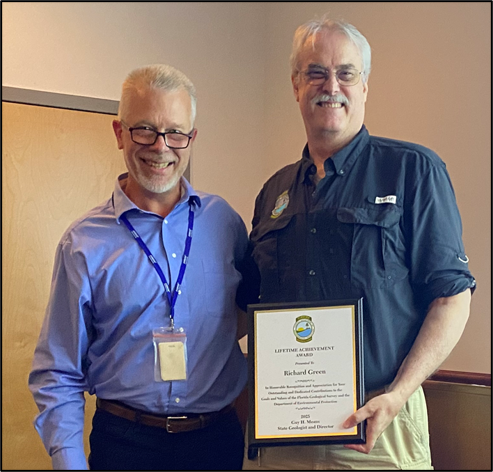
Welcome to the Summer 2026 edition of the Florida Geological Survey (FGS) News and Research. The FGS recognized several outstanding members of our team at our annual FGS Awards Ceremony held on February 13, 2026. Awards presented included both individual and team extra effort awards, employee of the year award and a sustained exemplary performance award. The Herman Gunter Lifetime Achievement Award was given this year to a very deserving staff member, Rick Green. During his 40 years at the FGS, Rick has been the lead author or a coauthor on 61 FGS publications, served for over three decades as the STATEMAP Program Coordinator and managed and trained many research assistants, including me! It was my honor to present Rick with the FGS’s most prestigious award for his accomplishments and many years of dedicated service. Read below to learn who the other very worthy award recipients were.
The FGS greatly values our collaborations with local, state and federal agencies, as well as with universities and the private sector. As Director, it is my goal to increase our opportunities for collaboration. I am pleased to report that the Florida Legislature allocated a line-item appropriation of $2.6 million, sponsored by Representative Shoaf and supported by Senator Simon, to the FGS to fund the Wakulla Basin GIS Mapping Initiative. This initiative supports ongoing research partnerships with SUNFISH, Inc., the Woodville Karst Plain Project, Florida State University and University of South Florida. Read more about this and other recent happenings in our FGS News section below.
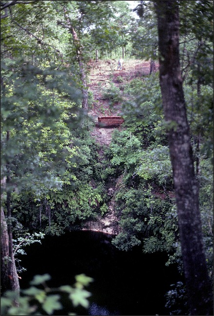
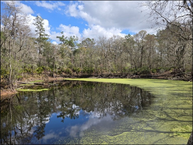
In this newsletter we focus on the Ocala Karst District, located between Tallahassee and Tampa, Florida. This geomorphic district is underlain by the Eocene Ocala Limestone, deposited between 37.7 and 33.9 million years ago, and contains a diversity of karst features including sinkholes, caves, springs and disappearing and reappearing streams. This is one of the largest geologically young karst terrains in the world. Learn how these karst features developed due to the gradual dissolution of carbonate rocks, like limestone, by naturally acidic water in GEOFACT: What is karst? Read about where the Sante Fe River disappears underground and later reemerges in Geology in …the Real Florida: O’Leno State Park and River Rise Preserve State Park. For more information on the karst features in this district, see our December 2024 FGS News and Research, which included articles on the geology of Edward Ball Wakulla Springs State Park, Leon Sinks Geological Area and the Aucilla Sinks.
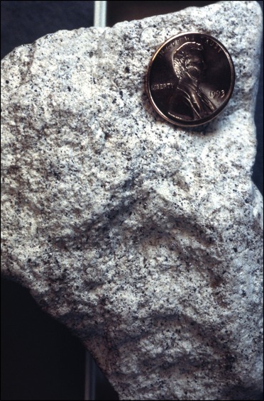
In parts of the Ocala Karst District, the Ocala Limestone is overlain by the Hawthorn Group. The Hawthorn Group is comprised of carbonate, quartz sand and clay that was deposited in shallow marine environments as sea level rose and fell in Florida during the late Oligocene (~28-23 million years ago) to the early Pliocene (~5-3.6 million years ago). In Featured Formation: Undifferentiated Hawthorn Group, learn about one of the most complex lithologic units in the southeastern U.S. Phosphate within the Hawthorn Group has been mined in Florida since the 1880s. Earth MRI: Phosphate Mine Waste Characterization discusses how the FGS is evaluating phosphate mine waste for critical mineral potential.
An important part of our mission is to maintain and distribute geologic information to benefit Florida. Our Geoscience Information and Data Management (GIDM) section has been hard at work creating new StoryMaps that allow the public to explore FGS geological resources online. Dive into four new FGS StoryMaps in Geologic Stories: Web Apps with Purpose.
I recently had the pleasure of being interviewed by WFSU’s Rob Diaz de Villegas about one of my favorite places in Florida, Alum Bluff, Florida’s first state invertebrate paleontological site and ninth state geological site. My father, Dr. Bruce Means, and my friend and colleague Roger Portell joined me in the interview. Dad, Roger and I have spent many years exploring Alum Bluff and the surrounding area. In Alum Bluff: Fossil Hotspot of the Apalachicola River, we shared our different research interests and experiences to help the audience appreciate distinct but associated aspects of Alum Bluff.
Finally, please mark your calendars for our upcoming open house! We will open our doors to the public on Friday, October 16, 2026, from 11:00 a.m. until 3:00 p.m. We look forward to seeing you all there!
As always, thank you for your continued support of our organization.
Sincerely,
Guy H. Means
Director and State Geologist
Florida Geological Survey
Florida Department of Environmental Protection
In this issue...

Legislature Funds Wakulla Spring Cave 3D Mapping and Hydrogeologic Research
For fiscal year 2025, the Florida Legislature allocated a line-item appropriation of $2.6 million, sponsored by Representative Shoaf and supported by Senator Simon, to the FGS to fund the Wakulla Basin GIS Mapping Initiative. The initiative’s objectives include:
- Use an autonomous underwater vehicle (AUV) to begin 3D mapping of the Wakulla Spring Cave system.
- Create a unified geospatial database of cave survey and water quality data.
- Research groundwater flow dynamics within the cave system in relation to previously published local and regional groundwater flow models.
- Model groundwater quality dynamics within the Wakulla Springs basin and cave system.
Over 60% of the appropriated funds are allocated to AUV 3D cave mapping using a vehicle named SUNFISH (Figure 1). SUNFISH, Inc. will use the funds to conduct 3D cave mapping using a first-generation SUNFISH AUV while simultaneously building two new second-generation SUNFISH AUVs for future 3D mapping. In addition to 3D cave mapping, the SUNFISH AUV will collect continuous groundwater flow velocity, conductivity, temperature, nitrate concentration, dissolved oxygen, pH and color data. Woodville Karst Plain Project scientific cave divers will use approximately 25% of the appropriated funds to assist with the AUV 3D mapping, collect water samples and create a geospatial database of cave survey and water quality data. Florida State University (FSU) and University of South Florida (USF) researchers, collectively, will receive nearly 15% of the funds. Data collected by the AUV will help inform modeling research conducted by both universities. The project’s ultimate goal is to help state and local regulators, conservationists and scientists better understand and protect the area’s surface water and groundwater resources. The project is contracted through FSU and will be complete by June 2027.
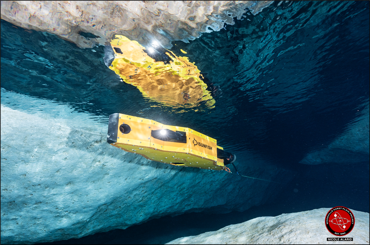 |
Figure 1. AUV 3D cave mapping performed by SUNFISH. Image credit: Nicole Alarid, courtesy of the Woodville Karst Plain Project.
Rick Green Honored with the Herman Gunter Lifetime Achievement Award
Rick Green was recognized for his distinguished career at the FGS with the Herman Gunter Lifetime Achievement Award (Figure 2). This award is named in honor of Herman Gunter, who was associated with the FGS for nearly 52 years, 39 of which he served as the FGS Director and Florida’s State Geologist. The Herman Gunter Lifetime Achievement Award is bestowed on an individual who has satisfactorily served and contributed greatly to the goals of the FGS or to the understanding of Florida’s geology over a period greater than 20 years.
In January of 1986, Rick was hired at the FGS as a Research Assistant. He attained his Professional Geologist license in 1994, the same year he took over the STATEMAP Program as manager. He was promoted to Professional Geologist (PG) I in December of 1999, PGII in July of 2008 and finally PGIII in September of 2017. During his tenure, Rick has been the lead author or a coauthor on 61 FGS publications that include Bulletins, Biennial Reports, Map Series, Open-file Map Series and Open-file Reports. He managed numerous Research Assistants over his three decades as the STATEMAP Program Coordinator, including FGS Director and State Geologist Harley Means! Rick has provided guidance to numerous FGS geologists based on his vast knowledge and experience in conducting geologic mapping across the state.
Additionally, Rick has served as lead editor and chair of the FGS Publications Committee for many years. As a result of his careful and methodical editorial reviews, Rick has made FGS publications highly respected and sought after. Rick, we thank you for your 40 years of service! You will leave a lasting and meaningful legacy at the FGS.
Figure 2. Rick Green (right) receives the Herman Gunter Lifetime Achievement Award from FGS Director and State Geologist Harley Means (left).
FGS Award Ceremony Recognizes Outstanding Team Members
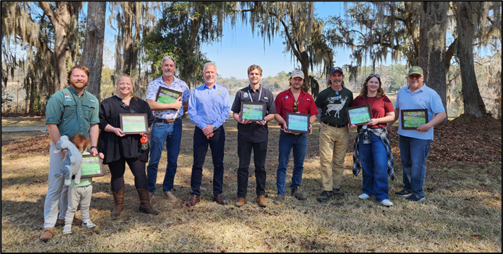
Exemplary FGS team members were recognized at the annual FGS Awards Ceremony on Friday, February 13, at Alfred B. Maclay Gardens State Park. The Cypress Pool Dye Trace Team members received the Team Extra Effort Award (Figure 3). Led by Jade Greene, Gary Fowler and Mary Beth Lupo, the team included Alan Baker, Amanda Kubes, Benjamin Davis, Casey Albritton, Clint Kromhout, Daniel Fisher, David Paul, Ericka McMahan and Scott Dyer. Alan Baker earned the Individual Extra Effort Award and Ben Davis received the FGS Employee of the Year Award. Mary Esposito was honored for her Sustained Exemplary Performance.
The organizing committee responsible for the ceremony and bestowing awards was chaired by Mary Beth Lupo and included Amanda Kubes, Sean Jones, Hannah Hajec and Jo Martinez.
Figure 3. Cypress Pool Dye Trace Team members received the FGS Team Extra Effort Award. From left to right: Ben Davis and Mary Beth Lupo (with their son), Alan Baker, Harley Means, Jade Greene, Gary Fowler, Scott Dyer, Amanda Kubes and Daniel Fisher.
Alum Bluff Featured on WFSU’s Ecology Blog
In Alum Bluff: Fossil Hotspot of the Apalachicola River, WFSU’s Rob Diaz de Villegas interviews State Geologist Harley Means about designating Alum Bluff as Florida’s first state invertebrate paleontological site and ninth state geological site (Figure 4). The interview contains video footage of the four geologic units exposed at Alum Bluff and information about the geologic history and paleongology of the site, including the formation of the 125-foot-tall bluff along east side of the Apalachicola River. Florida Museum of Natural History Invertebrate Paleontology Collection Director Roger Portell describes the richness of fossils, noting the 1,100 species of marine mollusks that have been described from the Chipola formation. Also joining Harley in the interview is his father, Coastal Plains Institute President Emeritus Bruce Means. Together they connected the underlying geology to the steephead ravines that develop on the surface, and describe how these unique geomorphic features serve as refugia for endemic species.
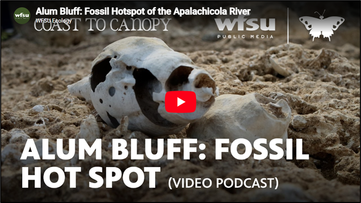 |
Figure 4. Click here to watch Alum Bluff: Fossil Hotspot of the Apalachicola River.
FGS Represented at USGS Earth MRI Workshop
FGS Geologists Gary Fowler, Mary Beth Lupo and Harley Means attended the U.S. Geological Survey’s (USGS) Earth Mapping Resources Initiative (Earth MRI) Workshop and training event held at their headquarters in Reston, Virginia, from January 26 – 30, 2026 (Figure 5). The annual workshop focused on updates to the program, future funding opportunities and federal and state partner progress. Recent highlights include Earth MRI publications and data releases, including geochemical analyses, mine waste X-ray diffraction data and airborne geophysical data. According to the Earth MRI Mapping and Science website, “Earth MRI is leveraging advanced technology to collect a suite of data that is important for understanding the Nation’s geology and critical mineral and other geologic resources. Each data set provides different information about how the Earth’s geologic puzzle pieces fit together: when combined, they provide a sophisticated, three-dimensional understanding of the Nation and its resources.” Learn how the FGS is contributing to this understanding in Earth MRI: Phosphate Mine Waste Characterization.
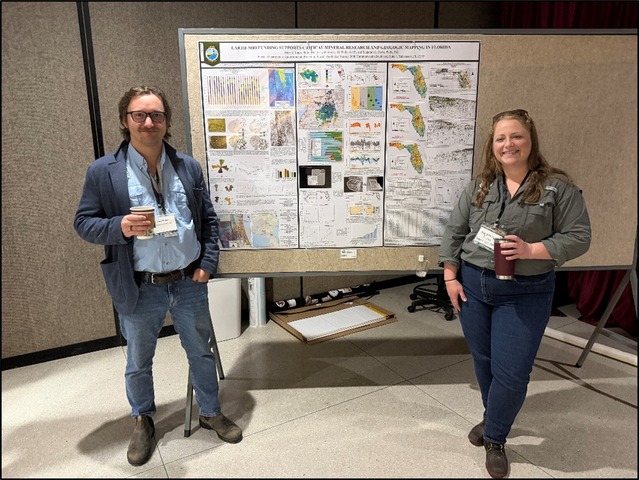 |
Figure 5. Gary Fowler and Mary Beth Lupo in front of their poster at the Earth MRI Workshop.
Expanded Education and Outreach Online Opportunities and Resources
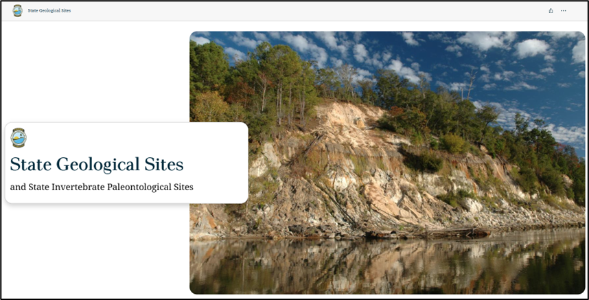
To serve more classrooms and educators throughout the state of Florida, the online offerings of the FGS Education and Outreach program have expanded! In addition to providing face-to-face and virtual tours of the Walter Schmidt Museum of Florida Geology, we now maintain a website dedicated to Florida-specific geoscience educational resources. Resources are organized by topic and created by the FGS or other government or academic institution. The available resources pertain to Florida geology or are requested by Florida teachers to address Florida's State Academic Standards for Science. Learn more about StoryMaps recently created (Figure 6) and added to our website in Geologic Stories: Web Apps with Purpose. For more information, please contact Mabry Gaboardi Calhoun.
Figure 6. Click here to explore the State Geological Sites and State Invertebrate Paleontological Sites StoryMap.
FGS Collaborates with Florida State University Faculty to Support Geoscience Education and Career Development
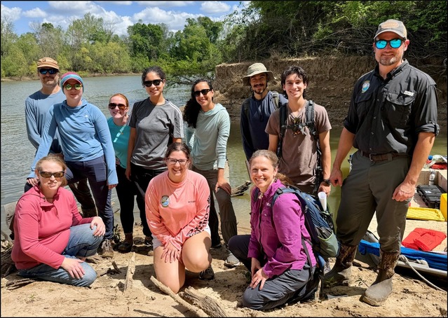
The FGS continues to collaborate with university faculty to provide students with opportunities to explore geoscience careers. FGS scientists participated in virtual discussions with students at Louisiana State University about the geology of the Citronelle Formation that occurs along the Gulf Coast. FGS staff also provided face-to-face presentations to students in the FSU Department of Earth, Ocean and Atmospheric Science (EOAS) on Geographic Information Systems (GIS) and the Geology of the Perry and Woodville Karst Plain. State Geologist Harley Means also spoke with students at USF and FSU about preparing for a career in geology. To increase field learning opportunities for college geoscience students, the FGS partnered with FSU Researcher Maya Stokes as she and her graduate students explored and mapped secondary channels along the Apalachicola River (Figure 7).
Figure 7. FGS staff with FSU Researcher Maya Stokes and her students at the mouth of Bee Tree Slough.
FGS Director and State Geologist Attends the Association of American State Geologists Spring Liaison
FGS Director and State Geologist Harley Means attended the Association of American State Geologists (AASG) Spring Liaison in Washington, D.C., from February 22 through February 26, 2026. A total of 19 State Geologists were in attendance. Attendees met with Congressional offices, federal agency leadership and non-governmental agencies to advocate for federal funding for three key USGS programs that provide cost-share funding to state surveys. The programs include the Earth Mapping Resources Initiative (Earth MRI), the National Cooperative Geologic Mapping Program (NCGMP) and the National Geological and Geophysical Data Preservation Program (NGGDPP). Click here for more information about these programs.
Recent FGS Publications
Lupo, M.E., and Greene, J.W., compilers, 2026, Florida Geological Survey Biennial Report 33, 2023-2024: Florida Geological Survey Biennial Report 33, 35 p., https://doi.org/10.35256/BR33.
Lupo, M.E., Davis, B.L., McMahan, E.L., and Means, G.H., 2026, Geologic Mapping in the Trail Ridge Placers, Florida Focus Area: Florida Geological Survey Report of Investigation 123, 129 p., 3 pl., https://doi.org/10.35256/RI123.
Davis, B.L., 2026, The Lithostratigraphy of the Lawson Formation: Florida Geological Survey Open-File Report 116, 29 p., https://doi.org/10.35256/OFR116.
Contact: Mabry Gaboardi Calhoun, PhD
Back to top

Sinkholes and springs are diagnostic karst features found in many areas of Florida, and they vary in size and occurrence. Between Tallahassee and Tampa, many sinkholes and large springs are concentrated in an area referred to as the Ocala Karst District. What is karst? How does it form? And how does that relate to the abundance of springs and sinkholes in this geomorphic district?
Origin of the Term Karst
The word “karst” is a German adaptation of “kras," which is Slovakian/Croatian and means “barren stony waterless ground” (Field, 2002; Ford and Williams, 2007; Upchurch et al., 2019). The Kras area is a limestone plateau in the Eastern Alps between Slovenia and Italy, where water often drains into solution features instead of ponding or flowing over the surface. The location is famous for its caves and sinkholes, including the Škocjan Caves recognized as a World Heritage Site by UNESCO (the United Nations Educational, Scientific and Cultural Organization). This region, called the Dinaric Karst region, is often referred to as the “Classical Karst” (Ford and Williams, 2007). Prior to its Germanized adaptation, the Romans referred to the Dinaric Karst region as Carsus and Carso (Ford and Williams, 2007).
What is karst and how does it develop?
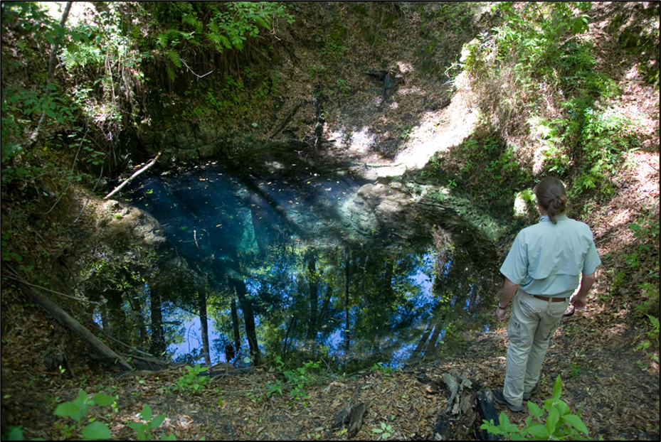
Geologists use the term karst to refer to a landscape characterized by solution features that develop on soluble rock, like limestone, dolostone, gypsum or anhydrite. Topographic landforms characteristic to karst terrains include sinkholes, springs, disappearing and reappearing streams and caves. Florida has all of these (Figure 1).
Figure 1. A picturesque water-filled sinkhole in the Ocala Karst District.
Karst terrain has unique hydrologic characteristics and topographic landforms due to secondary porosity, or pore spaces in rock developed by dissolution. When sediment is initially deposited, it naturally contains small pores, which water can either move through, if pores are interconnected, or be trapped in. This primary porosity forms when the rock forms or the sediment is deposited. Some of the primary porosity can be lost after deposition as pores infill with calcite in a process called diagenesis. For a deeper exploration of carbonate porosity and diagenesis, refer to Upchurch et al. (2019). Porosity that develops by either physical or chemical processes after rock has formed is called secondary porosity. Formation of joints and fractures in rock or sediment are examples of physical processes that create secondary porosity. Joints and fractures help form preferred pathways for infiltrating water along which chemical dissolution can occur. Chemical dissolution is the main process that creates secondary porosity. Carbonate dissolution creates secondary porosity that leads to formation of a karst terrain.
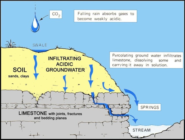
Rain (H2O) falling through the atmosphere onto the land surface and infiltrating into the soil chemically interacts with carbon dioxide (CO2). As this occurs carbonic acid (H2CO3) is naturally formed. Carbonic acid is a weak acid (like tomato or orange juice), but it is strong enough to ever so slowly dissolve Florida’s carbonate rock, which is predominantly limestone. As the limestone is dissolved, the infiltrating water enlarges the pores over time, forming voids (Figure 2). Over time as voids enlarge they can connect and form a system of caves, sinkholes, springs and disappearing and reappearing streams.
Figure 2. Diagram illustrating chemical and physical processes that lead to karst terrain formation. Modified from FGS Special Publication 29, Karst in Florida.
Aquifer Systems
Porosity enables the rock and sediment to store water in the form of an aquifer, a body of rock or sediment that holds and transmits water. An aquifer gets its water from precipitation that falls onto the land surface, infiltrates into the ground and migrates through the pores in the rock and sediment. Interconnected pores make the rock and sediment permeable, meaning that water can flow through. Carbonates with secondary porosity make excellent aquifers because they have high porosity and high permeability.
Some sediments, like clays, have very few connected pore spaces, meaning that clays have low permeability. Clays may absorb and hold water well, but they act as a barrier to the water and do not transmit water well. Layers of impermeable sediments that overlie an aquifer are referred to as confining units because they confine the movement of water.
These sequences of rock and sediment form aquifers and aquifer systems (a collection of variably interconnected aquifers separated by confining units). Aquifers in karst terrains are some of the most productive aquifers in the world due to the carbonate rocks containing significant primary porosity and well-developed secondary porosity. This enables karst aquifers to store, move and produce large quantities of water very easily. Florida’s karst is home to multiple aquifer systems, the largest of which is the Floridan aquifer system. The Floridan aquifer system underlies the entire state and is the primary drinking water resource for most of Florida.
Why does Florida have karst?
Florida is a geologically young carbonate platform, whose bedrock is comprised of thousands of feet of limestone and dolostone. Over that platform is a variably thick sequence of interbedded sands, clays and carbonates with a veneer of sediment and soil lying on top. For an in-depth overview of Florida’s geology, refer to Florida Geological Survey Open File Report 50, A Geological Overview of Florida.
Geologically young carbonate rocks that have not been transformed by heat or pressure through time retain much of their original primary porosity and bedding planes from deposition. Karst that forms in this type of geologic environment is called eogenetic karst. Florida contains one of the largest expanses of eogenetic karst in the world (Upchurch et al., 2019; Williams et al., 2022).
Bedding planes in eogenetic karst can be zones of weakness or higher porosity, allowing infiltrating rainwater or flowing groundwater to move more easily. Naturally formed carbonic acid can chemically dissolve the rock along bedding planes, fractures and joints creating secondary porosity. A second chemical and physical process that forms a natural weak acid leading to the formation of secondary porosity is by the mixing of two chemically different groundwaters. Over geologic time the formation of secondary porosity can lead to the formation of voids and cave passages in carbonate rock, such as what is observed in Florida’s carbonate rocks. The formation of well-developed secondary porosity enables the formation of karst, and this happens more readily in geologically young carbonates like those present in Florida.
Karst Landforms
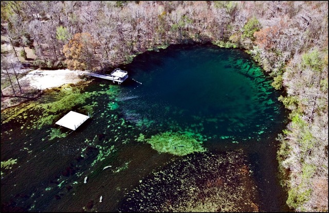
Florida has one of the largest concentrations of karst springs in the world with over 1,100 documented to date. The 1,100 documented springs include 33 first-magnitude springs, more than anywhere else in the world. First-magnitude springs emit more than 64.6 million gallons of water per day, most of which are found in Florida's state parks. This includes famous springs like Rainbow Springs (Figure 3), Silver Springs, Blue Spring (Volusia County), Ichetucknee Springs, Weeki Wachee Springs and Wakulla Spring (Figure 4). Wakulla Spring is world famous and is listed as World Geoheritage Site #186 out of 200 by the International Union of Geological Sciences. The state park where the spring resides, Edward Ball Wakulla Springs State Park, is a state geological site. Wakulla Spring is the largest single vent spring in the U.S. It also has the longest mapped underwater cave system in the U.S., exceeding 44 miles of cave diver explored passage.
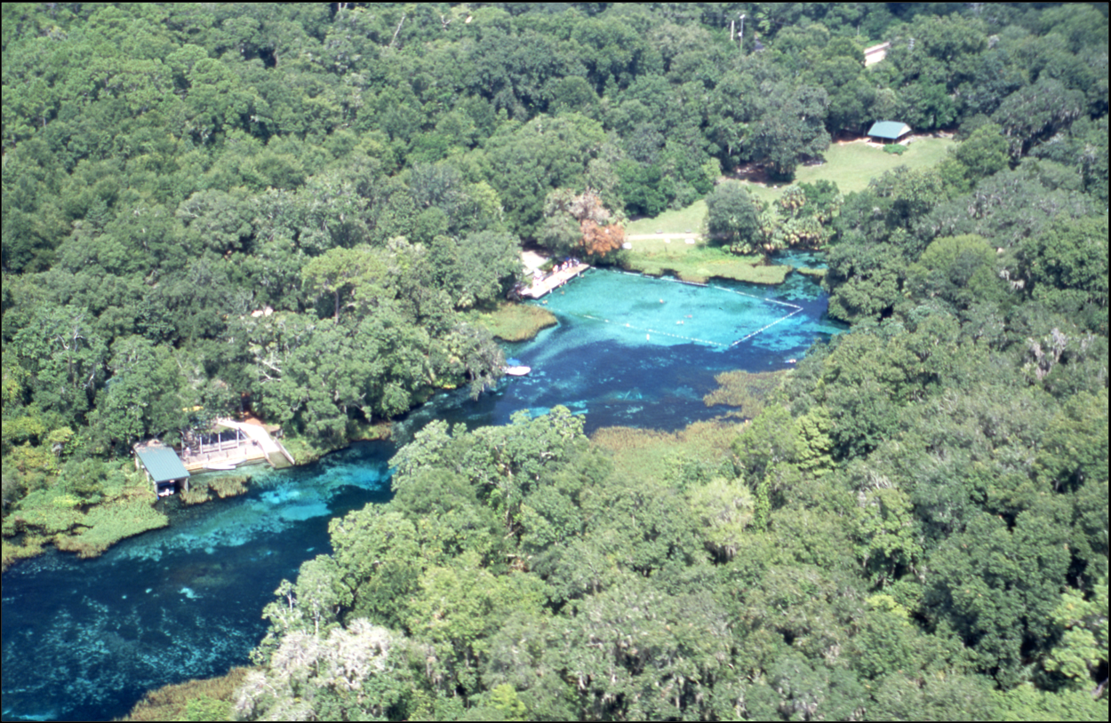 |
Figure 3. Aerial photograph of Rainbow Springs, taken in 2004. The springs, near the roped off swimming area, provide water to the Rainbow River, flowing to the lower left.
Figure 4. Aerial photograph of Wakulla Spring with the Wakulla River flowing to the lower left.
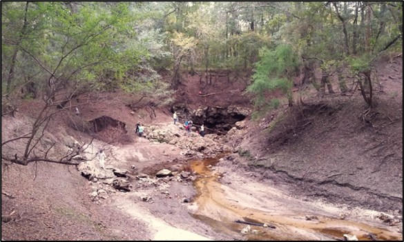
Disappearing and reappearing streams are another hallmark of karst terrains, and Florida has many. These special streams begin as normal streams, but along their flow path they encounter a sinkhole which swallows the entire flow of the stream. At some distance and at a lower elevation, the stream reappears as a river rise, also called a spring. Notable disappearing and reappearing streams in Florida include the Santa Fe River, St. Marks River, Aucilla River, and the Dead River. The Dead River is located on the Jennings Bluff Tract, a Florida state geological site. The Dead River captures flow from the Alapaha River during low water conditions and drains into the Dead River swallet (Figures 5 and 6) and the flow reappears 10 miles south emerging at two locations, Holton Creek Rise and Alapaha Rise. A swallet is the name given to a sinkhole that swallows a stream. They are also called swallow holes or ponors, which is the Slavic term (Field, 2002).
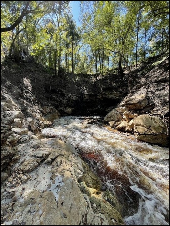 |
Figure 5. Dead River swallet. Water from the Dead River flows into this sinkhole and enters the underlying aquifer and becomes groundwater.
Figure 6. FGS geologists on the Dead River, which drains to the Dead River swallet.
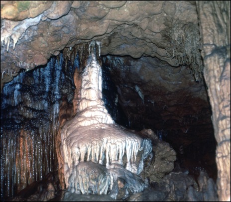
Caves are a common feature in karst terrains, and Florida has many. Today, most of Florida’s caves are groundwater-filled in the Floridan aquifer system. At times in the geologic past, when sea level was lower, groundwater levels were lower and some of these caves were air-filled (Figure 7). The geologic units that support those caves are mostly the Ocala Limestone and Suwannee Limestone, both of which are at or near land surface in Florida’s central-western peninsula, northern Florida and Florida’s eastern panhandle. Air caves do exist in these areas, but they are generally not publicly accessible and are located on private property. Florida Caverns in Florida Caverns State Park (Figure 8) is the only publicly accessible open-air cave in Florida. Located in Marianna, Florida, it is a state geological site.
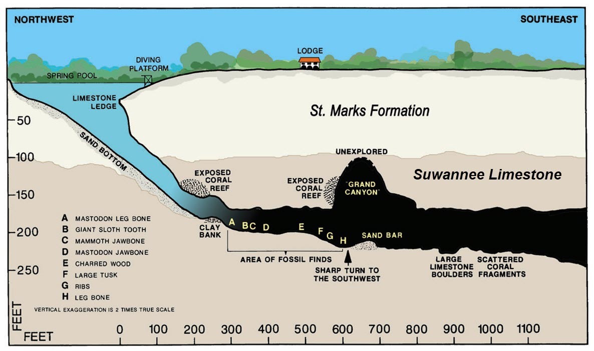 |
Figure 7. FGS geologists recovered mastodon remains from Wakulla Spring in the 1930s. The above cross section of Wakulla Spring was drawn by Andrew Janson, a scientific illustrator with the FGS in the 1950s. Fossil remains, indicated in the drawing by the letters, were found well below current water levels. Sea level was much lower during the glacial stages of the Pleistocene epoch, resulting in lower groundwater levels. Though Wakulla Spring and the associated cave system are now groundwater-filled, the vent was open-air in the geologic past, allowing surface access to the cave.
Figure 8. Flowstone in Florida Caverns in Florida Caverns State Park.
Sinkholes
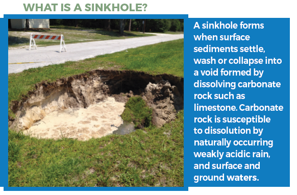
The most common diagnostic features of karst terrains are sinkholes. As discussed earlier, karst develops where significant secondary porosity exists, formed by naturally weak acid dissolving the underlying carbonate rock. This secondary porosity can create large voids and caves. Weaknesses in the rock and sediment above the voids and caves can cause the rock and sediment to settle, ravel or collapse into the void below forming a sinkhole on the land surface (Figure 9).
Figure 9. A Homeowner’s Guide to Sinkholes in Florida provides information about sinkhole formation.
There are different types of sinkholes. The type of sinkhole that forms is dependent upon the character and thickness of the underlying geologic units, the size and depth to the void(s) and hydrology and hydrogeology at that site.
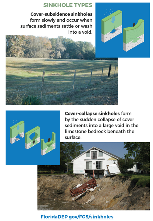
Solution-subsidence or cover-subsidence sinkholes (Figure 10) are slow forming sinkholes. They generally occur in areas where the sediment above the carbonate rock or shell-bearing sediments (fossil shells are composed of calcium carbonate like limestone) is variably thick and is unconsolidated to poorly consolidated. This sediment is called overburden. The unconsolidated to poorly consolidated overburden can move freely down, ravel, into an underlying void under the influence of gravity and water. Because this sediment moves freely, a small amount can move at a time allowing the sinkhole to develop slowly over time. Additionally, where the carbonate sediment and rock below ground are uniformly dissolved, the land surface will slowly subside forming a depression.
Figure 10. Sinkholes can form in a variety of ways, as detailed in A Homeowner’s Guide to Sinkholes in Florida. Cover-subsidence (top) and cover-collapse sinkholes (bottom) are shown here.
Cover-collapse (Figure 10) and rock-collapse sinkholes are fast forming sinkholes. They form where the overburden sediment is moderately to well consolidated or has relatively thin rock ceiling above a void. These overlying features do not move freely and may remain in place until an event causes them to collapse quickly. Over time, as water infiltrates or aquifer groundwater levels fluctuate, the sediments and/or rock above the void can be weakened and abruptly collapse, forming a sinkhole on the land surface.
Although the idea of a sinkhole forming can be alarming, sinkholes can be beautiful and unique karst features to visit. Florida offers multiple state parks dedicated to the beauty of sinkholes, several of which are state geological sites, including Devils Millhopper Geological State Park, Falling Waters State Park and Paynes Prairie Preserve State Park. Additionally, Leon Sinks Geological Area (Figure 11), in the Florida Panhandle’s Apalachicola National Forest just south of Tallahassee, is an excellent location to observe sinkhole formation and karst terrain.
Figure 11. Big Dismal Sink at the Leon Sinks Geological Area. FGS News and Research article The Geology of Leon Sinks Geological Area provides information on the stratigraphy of the area.
For further information about sinkholes, please refer to FGS sinkhole resources, including our website, FGS Leaflet 20, A Homeowner’s Guide to Sinkholes in Florida and FGS Special Publication 57, Geological and Geotechnical Investigation Procedures for Evaluation of the Causes of Subsidence Damage in Florida.
References and Suggested Resources
Field, M.S., 2002, A Lexicon of Cave and Karst Terminology with Special Reference to Environmental Karst Hydrology: United States Environmental Protection Agency EPA/600/R-02/003, 221 p., https://karstwaters.org/wp-content/uploads/2015/04/lexicon-cave-karst.pdf.
Florida Geomorphology Atlas online interactive map: https://experience.arcgis.com/experience/3fc273fccab8499083960daf7f1207a7.
Ford, D.R., and Williams, P.D., 2007, Karst Hydrogeology and Geomorphology: West Sussex, England, John Wiley & Sons Ltd., 562 p., https://doi.org/10.1002/9781118684986.
Lane, E., 1986, Karst in Florida: Florida Geological Survey Special Publication 29, 100 p., https://doi.org/10.35256/SP29.
Hannon, L., and Kromhout, C., 2023, A Homeowner's Guide to Sinkholes in Florida: Florida Geological Survey Leaflet 20, 11 p., https://doi.org/10.35256/L20.
Schmidt, W., compiler, 2005, Geological and Geotechnical Investigation Procedures for Evaluation of the Causes of Subsidence Damage in Florida: Florida Geological Survey Special Publication 57, https://doi.org/10.35256/SP57.
Upchurch, S., Scott, T.M., Alfieri, M.C., Fratesi, B., and Dobecki, T.L., 2019, The Karst Systems of Florida, Understanding Karst in a Geologically Young Terrain: Cham, Switzerland, Springer International Publishing AG, 450 p., https://doi.org/10.1007/978-3-319-69635-5.
Williams, C.P., Scott, T.M., and Upchurch, S.B., 2022, Florida Geomorphology Atlas: Florida Geological Survey Special Publication 59, 238 p., https://doi.org/10.35256/SP59.
Contact: Clint Kromhout, PG
Suggested Citation
Kromhout, C., 2026, What is Karst: FGS News and Research Summer 2026 edition. https://content.govdelivery.com/accounts/FLDEP/bulletins/417d410#link_1.
Back to top
O’Leno State Park and River Rise Preserve State Park allow visitors an opportunity to see a unique geologic feature: a river that disappears underground and reappears several miles away. Originally a forestry camp constructed in the 1930’s by the Civilian Conservation Corps (CCC) and the Works Progress Administration (WPA), O’Leno State Park was built on the remnants of the 19th century mill town of Leno (originally named Keno). O’Leno State Park (2,372 acres) is one of Florida’s nine original state parks and serves as a recreational area for the public that features hiking trails, a swimming front on the Santa Fe River and campsites. Neighboring River Rise Preserve State Park (currently 4,005 acres), acquired in 1974, includes equestrian trails and additional campsites.
O’Leno State Park resides in the Branford Karst Plain Province of the Ocala Karst District. The region is underlain by Eocene Ocala Limestone, which is highly porous and permeable. Because of this, the Ocala Limestone is an important part of Floridan aquifer system, the drinking water source for most Floridians. Core W-18467, drilled in the park and described by the FGS, contains 18 feet of Quaternary undifferentiated sands and clays overlying the Ocala Limestone, which is present to 178 feet, the total depth of the core. In the Ocala Karst District, the limestone is close to the surface making it vulnerable to dissolution by meteoric waters. Over time, slightly acidic rainwater dissolves the limestone to produce karst features, like caves, sinkholes, swallets and springs.
Figure 1. The Santa Fe River flowing through O'Leno State Park.
The Santa Fe River (Figure 1), starts at Lake Santa Fe in Bradford County and flows in a westerly direction. It crosses through the Alachua Karst Hills Province, where karst features are larger than those in the neighboring Branford Karst Plain Province (Williams et al., 2022). This is due to thicker sediments above the limestone. The Cody Escarpment, an erosional feature associated with an ancient shoreline, forms the boundary between these two provinces and delineates a difference in geology and karst features (SRWMD, 2026; Williams et al., 2022). Santa Fe Spring, a first-magnitude spring (discharge greater than 64.6 million gallons/day), provides a large input of groundwater to the river. Before reaching O’Leno State Park, however, a portion of the river is diverted by the Vinzant Landing Swallet, a sinkhole that drains water underground.
Figure 2. River Sink in O'Leno State Park.
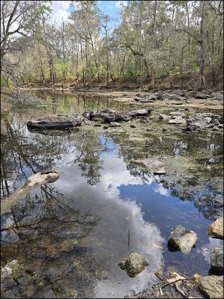
Within O’Leno State Park, the Santa Fe River continues for several miles before it disappears into a swallet named River Sink that is approximately 120 feet deep (Figure 2). The water travels through an underground conduit through the limestone before reemerging approximately three miles south at Santa Fe River Rise, a first-magnitude spring within River Rise Preserve State Park. The stretch between the River Sink and the River Rise is known as a natural bridge and is locally referred to as O’Leno Natural Bridge or the Santa Fe Trace. This region includes various karst windows, sinkholes that are connected to the aquifer, as well as the river floodplain that is periodically inundated during major flood events.
O’Leno State Park and River Rise Preserve State Park protect distinct karst features of the Santa Fe River and support natural areas for the benefit of conservation and the provision of resource-based recreation (FDEP, 2024, p. 2). The management plan for these parks identifies 20 different environments including mesic and xeric hammocks, uplands, mesic and scrubby flatwoods, sandhill, sinkhole lake, swamps and alluvial forest. Each of these have their own distinct soils, hydrology and biology.
These parks are home to several imperiled plant and animal species. The Florida Department of Environmental Protection (DEP) and the Florida Fish and Wildlife Conservation Commission (FWC) continue to maintain and restore several areas of the parks to improve the populations. The two parks also have a combined 75 recorded archaeological sites, attesting to the rich cultural history of the area. The O’Leno Natural Bridge has historically been an important route across the Santa Fe River. Still used today, this natural bridge was part of one of the first routes between St. Augustine and Tallahassee.
References Cited
Florida Department of Environmental Protection, 2024, O’Leno State Park and River Rise Preserve State Park ARC Draft UMP, Management Plan, https://floridadep.gov/parks/parks-office-park-planning/documents/o%E2%80%99leno-state-park-and-river-rise-preserve-state-park-arc.
Suwannee River Water Management District, What is the Cody Escarpment?, https://www.mysuwanneeriver.com/268/The-Cody-Escarpment, (accessed April 2026).
Williams, C.P., Scott, T.M., and Upchurch, S.B., 2022, Florida Geomorphology Atlas: Florida Geological Survey Special Publication 59, 238 p., https://doi.org/10.35256/SP59.
Contact: Michelle M. L. Ladle, PG
Suggested Citation
Ladle, M.M.L., 2026, Geology in …the Real Florida: O’Leno State Park and River Rise Preserve State Park: FGS News and Research Summer 2026 edition. https://content.govdelivery.com/accounts/FLDEP/bulletins/417d410#link_8.
Back to top
The undifferentiated Hawthorn Group is one of the most lithologically complex geologic units within the Cenozoic section in the southeastern U.S. In order to discuss these sediments, we must first briefly discuss the history and variability of the Hawthorn Group.
Dall and Harris (1892) named the “Hawthorne beds” for phosphatic sediments found near Hawthorne in Alachua County, Florida. Huddlestun (1988) renamed the unit the Hawthorne Group in Georgia and this usage was continued in Florida by Scott (1988). The reader is referred to Scott (1988) for a more detailed discussion of the history of the unit and various formations within the Hawthorn Group as they are beyond the scope of this article.
The Hawthorn Group sediments (Figure 1) consist of a complex mixture of carbonates and silica-rich sands and clays, or siliciclastics, deposited in shallow marine seas from the late Oligocene (~28-23 million years ago) to the early Pliocene (~5-3.6 million years ago) during multiple high sea-level stands. The thickness and specific lithologies were heavily influenced by paleotopography and water depth during deposition. The unit thickens significantly in areas that were topographically low at the time of deposition, such as the Okeechobee Basin in southern Florida and the Jacksonville Basin and the Southeast Georgia Embayment in northeastern Florida and southeastern Georgia. In areas that were topographically high, like the Ocala Platform in the north-central peninsula, the Hawthorn Group is thin or missing, most likely removed by subsequent erosion (Scott, 1988). In general, the Hawthorn Group can be divided into three broad areas of occurrence in Florida: the eastern panhandle, northern Florida, and southern Florida. Each of these areas has different formations present.
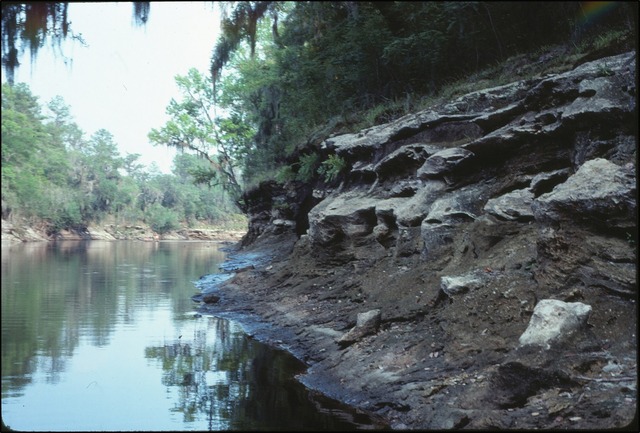 |
Figure 1. Hawthorn Group sediments exposed in the Suwannee River along the border between Hamilton and Columbia counites in northern Florida.
The Hawthorn Group in the eastern panhandle of Florida consists of the Torreya Formation with the Sopchoppy and Dogtown members (Scott, 1988). According to Scott (1988), the Torreya Formation consists of a carbonate-rich basal section with interbedded sands and clays and an upper section which is predominantly a siliciclastic and often contains a massive, clayey upper unit (Dogtown Member which is mined for Fullers Earth; Huddlestun, 1988). While phosphate is present in all units in the Hawthorn Group, it is noticeably less common in the eastern panhandle units than in the peninsular units.
The Hawthorn Group in northern peninsular Florida consists of four formations (in ascending order): the Penney Farms Formation, the Marks Head Formation, the Coosawhatchie Formation, and the Statenville Formation (Scott, 1988). The Coosawhatchie Formation grades laterally into the Statenville Formation in limited areas in Hamilton and Columbia counties. The Hawthorn Group sediments consist of a basal carbonate with interbedded siliciclastics (Penney Farms Formation; Scott, 1988), a complex system of interbedded carbonates and siliciclastics (Marks Head Formation; Huddlestun, 1988), a siliciclastic unit with variable percentages of carbonate in the matrix and individual beds (Coosawhatchie Formation; Huddlestun, 1988), and a cross-bedded unit which is predominantly siliciclastic (Statenville Formation; Huddlestun, 1988). Phosphate grains are very common in these units and may comprise up to half of the sediments (Scott, 1988).
In southern Florida, the Hawthorn Group consists of the Arcadia Formation and the Peace River Formation (in ascending order). The Arcadia Formation is primarily a carbonate with varying amounts of siliciclastics and phosphate. The Arcadia Formation has two members: the Tampa Member and the Nocatee Member. More details about these members can be found in Scott (1988). The Peace River Formation (Scott, 1988) is predominantly a siliciclastic unit with some interbedded carbonates. It has one member (the Bone Valley Member), whose phosphorite deposits are prized for their economic value. These deposits have been the focus of extensive phosphate mining in central Florida.
While the various formations in the Hawthorn Group are a mixture of carbonates and siliciclastics, they all have one thing in common: the presence of phosphate grains. These range in size from sand and silt grains to pebble and gravel, and often give the sediments a “salt and pepper” appearance (Figure 2).
Figure 2. Phosphate grains in a quartz sandy, phosphatic dolostone from the Arcadia Formation within the Hawthorn Group.
The siliciclastic sediments, which are often greenish gray to gray in color, are dominated by fine-to-medium grained quartz sand and a variety of clays, including palygorskite and montmorillonite. The carbonates are often poorly to moderately indurated dolostones and limestones, with varying amounts of quartz sand and clay, which are frequently yellowish gray to cream in color.
Where the sections of the Hawthorn Group are thick, or where there are good cores or outcrops, the sediments can often be subdivided into one or more of the formations discussed above by recognizing packages of sediments with similar characteristics. The complex and interbedded nature of the formations in the Hawthorn Group, along with similarities in lithologies can, however, make differentiation of the various formations difficult where units are thin, weathered, or samples only consist of drill cuttings. In these cases, it is often not possible to differentiate the various formations within the Hawthorn Group. In these cases, geologists use the term undifferentiated Hawthorn Group to signify that the sediments are part of the Hawthorn Group, but the assignment of the sediments to a particular formation is uncertain. This “undifferentiated” designation is not merely a placeholder for lack of data, but it instead reflects the inherent variability and rapid facies changes that often occur in Hawthorn Group sediments. The usage of the term undifferentiated is a standard accepted practice in the field of stratigraphy, and it is applied when a package of rock or sediment exhibits characteristics of a group or formation, but those characteristics are not unique enough to classify further into formations or members.
In northern peninsular Florida, difficulty differentiating most often occurs along the edges of the Cody Scarp where the Hawthorn Group thins out and transitions into the karst plains of the Ocala Karst District (Williams et al., 2012; Evans et al., 2004). In central Florida, undifferentiated Hawthorn Group sediments are generally made up of clay beds with variable amounts of carbonate, quartz sand, silt, phosphate and minor organics and shell material (Arthur et al., 2008). Undifferentiated Hawthorn Group sediments grade laterally into the Peace River Formation towards the southeast in Hernando and Pasco counties (Green et al., 2011) and grade laterally into the Arcadia Formation in southern Pinellas County (Green et al., 2012).
References Cited
Arthur, J.D., Fischler, C., Kromhout, C., Clayton, J.M., Kelley, G.M., Lee, R.A., Li, L., O'Sullivan, M., Green, R.C., and Werner, C.L., 2008, Hydrogeologic framework of the Southwest Florida Water Management District: Florida Geological Survey Bulletin 68, 102 p., 59 pl., https://doi.org/10.35256/B68.
Dall, W.H. and Harris, G.D., 1892, Correlation papers: Neocene, U.S. Geological Survey Bulletin 84, 349 p., https://doi.org/10.3133/b84.
Evans, W.L., III, Green, R.C., Bryan, J.R., and Paul D.T., 2004, Geologic map of the western portion of the USGS 1:100,000 scale Gainesville quadrangle, northern Florida: Florida Geological Survey Open-File Map Series 93, scale 1:100,000, https://doi.org/10.35256/OFMS93.
Green, R.C., Williams, C.P., Burdette, K.E., Bassett, S.W., Flor, A.D., and Paul, D.T., 2011, Geologic map of the eastern portion of the USGS Inverness 30 x 60 minute quadrangle, central Florida: Florida Geological Survey Open-File Map Series 102, scale 1:100,000, 3 plates, https://doi.org/10.35256/OFMS102.
Green, R.C., Evans, W.E., III, Williams, C.P., Kromhout, C., Bassett, S.W., and Hannon, L.M., 2012, Geologic map of the USGS Tarpon Springs 30 x 60 minute quadrangle, central Florida: Florida Geological Survey Open-File Map Series 104, scale 1:100,000, 3 plates, https://doi.org/10.35256/OFMS104.
Huddlestun, P.F., 1988, A revision of the lithostratigraphic units of the Coastal Plain of Georgia: The Miocene through Holocene: Georgia Geologic Survey Bulletin 104, 162 p., https://dlg.galileo.usg.edu/data/dlg/ggpd/pdfs/dlg_ggpd_s-ga-bn200-pg3-bb1-bno-p-b104.pdf.
Scott, T.M., 1988, The Lithostratigraphy of the Hawthorn Group (Miocene) of Florida: Florida Geological Survey Bulletin 59, 148 p., https://doi.org/10.35256/B59.
Williams, C.P., Green, R.C., Bassett, S.W., Hannon, L.M., and Flor, A.D., 2012, Geologic map of the western portion of the U.S.G.S. Inverness 30 x 60 minute quadrangle, central Florida [3 plates]: Florida Geological Survey Open-File Map Series 103, scale 1:100,000, 3 pl., https://doi.org/10.35256/OFMS103.
Contact: Rick Green, PG
Suggested Citation
Green, R.C., 2026, Featured Formation: Undifferentiated Hawthorn Group: FGS News and Research Summer 2026 edition. https://content.govdelivery.com/accounts/FLDEP/bulletins/417d410#link_6.
Back to top
In 2019, the USGS Earth Mapping Resources Initiative (Earth-MRI) was established to collect geophysical, geochemical, geologic and topographic data in areas of critical mineral potential across the nation. In 2022, the FGS began a multi-year Earth-MRI project with the goal of characterizing phosphate mine waste for critical mineral potential. Phosphate mining has been active in Florida for over a century, mining primary marine phosphate deposits and their derivatives where they occur at or near the surface (Figure 1). Florida’s history of phosphate mining and processing of ore has resulted in varying types of mine waste distributed throughout its phosphate mining districts. Phosphate minerals, such as apatite, monazite and xenotime, are known hosts of rare earth elements (REEs) and are identified as Phase 1 strategic mineral resources by the Earth-MRI working group (Hammarstrom et al., 2020).
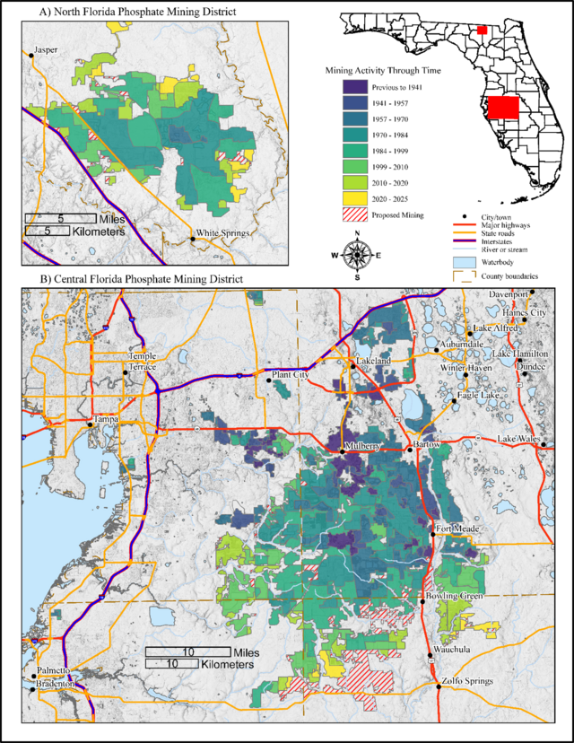 Figure 1. Phosphate mining and mine waste activity delineated through time. Area A represents the North Florida phosphate district near White Springs. Area B represents the Central Florida phosphate district east of Tampa.
Geology of Phosphate Ore in Florida
Phosphate mining in Florida dates to the 1880s and is categorized into two types of ore, hard rock phosphate and pebble phosphate (e.g., Sellards, 1913). Hard rock phosphate deposits occupy a roughly 100-mile strip east of and parallel to Florida’s Gulf Coast (Sellards, 1915). Hawthorn Group units commonly contain economic deposits of phosphate minerals (e.g., Matson, 1915; Riggs 1979; Scott, 1988; Huddlestun, 1988). Pebble phosphate deposits exist throughout many of the Oligocene – Pliocene units of the Hawthorn Group but are economically viable where the phosphatic beds of the northern Florida Coosawhatchie Formation and Statenville Formation as well as the central Florida Peace River Formation and its Bone Valley Member are exposed at land surface or are present in the shallow subsurface (e.g., Scott et al., 2001; Green et al., 2006; 2017; 2019).
Marine phosphorite deposits are typically associated with western continental margins influenced by trade-wind–driven upwelling or with equatorial east–west seaways where persistent upwelling occurs; however, deposits in the southeastern United States do not conform to these classic settings (Scott, 1988). Instead, an extensive system of coastal, shallow-marine shelf and platform settings developed in response to the structural framework of the Florida Peninsula, and these environments regulated Miocene phosphorite formation, deposition and accumulation (Riggs, 1980). Riggs (1984) suggests that analogous processes, particularly the interaction of ocean currents and localized upwelling, likely played a role in the phosphogeneis of the region. These coastal and shallow marine platform environments created optimum conditions for phosphorite formation, resulting in the concentrated phosphorite deposits mined in Florida (Riggs, 1980).
Mining Waste
Generally speaking, the mining process was similar for hard rock and pebble phosphate deposits, which includes stripping and excavating of open pit mines and subsequent washing, sorting and drying of product materials (Matson, 1915). Modern mining practices utilize large electric draglines to remove overburden and extract the ore-bearing layer (or matrix), with a single dragline capable of mining 15 acres in a month according to the Florida Institute of Phosphate Research (FIPR) and the USGS (2024). The matrix is transported to a pit where high-pressure water jets break it down into a slurry (similar consistency to a milkshake) that is then pumped to a beneficiation plant (e.g., Beavers et al., 2015). These plants, often several miles away, separate phosphate grains from sand and clay matrix material using washing, cyclones, screening and flotation techniques. Waste materials from these processes include sand tailings and clay slurry (Beavers et al., 2015). The waste slurry is pumped into large impoundment areas or ponds known as clay settling areas (CSAs) with the purpose of letting the suspended particles settle from the water. The phosphate industry leaves roughly 40% of the land it mines behind as CSAs, which makes phosphatic clay waste a large-scale byproduct of the phosphate mining process (Brown, 2005).
The manufacturing of phosphoric acid results in the formation of calcium sulfate (gypsum) as a byproduct (e.g., Taha et al., 2021). This gypsum is referred to as phosphogypsum (PG) which is acidic and mildly radioactive. Every ton of phosphoric acid produced results in five tons of PG byproduct (e.g., Taha et al., 2021). The Environmental Protection Agency (EPA) classifies PG as a technologically enhanced naturally occurring radioactive material (TENORM). Radioactivity in the PG is inherited from radioactive elements, such as uranium, thorium, radium and their decay products, which naturally occur in phosphate ore. The EPA prohibits the use of PG in construction materials (40 CFR 61 Subpart R) but PG with an activity less than 10 pCi/g (picocuries per gram) can be used for agricultural purposes. As a result, PG is stored in stacks similar to landfill structures, known as PG stacks, on unused land near production sites or mined out areas. Roughly 30 million tons of PG are generated each year (USGS, 2024).
Critical Mineral Characterization
The USGS Mineral Resource Program published a list of critical minerals classified by supply risk. REEs (Lanthanides and Yttrium) are the only materials on the list that exist in phosphate waste in significant concentrations (Figure 2). Three types of waste were analyzed in this study: 1) tailings and fill from previously mined areas, 2) settled slurry from closed CSA sites, and 3) PG from the Piney Point PG stack. These waste types are composed of distinct minerals as determined by X-Ray Diffraction (Figure 3). Tailings and fill material characterized consist of 50% or more quartz sand, almost 20% phosphate, 15% clay minerals, 10% carbonate and minor amounts of oxides and other silicate minerals. Two distinct groups emerge from the CSA sample analyses: group 1) with low amounts of quartz sand (<10%) and group 2) with high amounts of quartz sand (>50%). Group 2 CSA samples have similar mineralogy to tailings/fill samples, and both exhibit the lowest concentrations of REEs among the waste types (Figure 2). Group 1 CSA samples contain mostly clay (50% or greater) and phosphate (~40%) minerals, with the remaining 10% consisting of quartz sand and other silicates. Group 1 CSA samples also display the highest REE concentrations observed in phosphate mine waste (Figure 2). The PG is dominated by sulfate minerals (~90%) like gypsum, anhydrite, bassanite and meniaylovite, with the rest consisting of quartz sand and phosphate. PG has intermediate REE concentrations, overlapping with quartz rich waste on the low end and clay rich CSA samples on the high end.
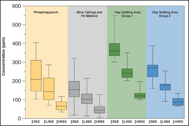 Figure 2. REE data plotted for phosphate mining waste. Multiple box and whisker plots for each type of mine waste for ∑REE, ∑LREE (light REE), and ∑HREE (heavy REE) concentrations. Whiskers show the maximum and minimum data point for each category. The top and bottom of each box is at the 1st and 3rd quartile of each category. The black line inside the box is the median point of each category.
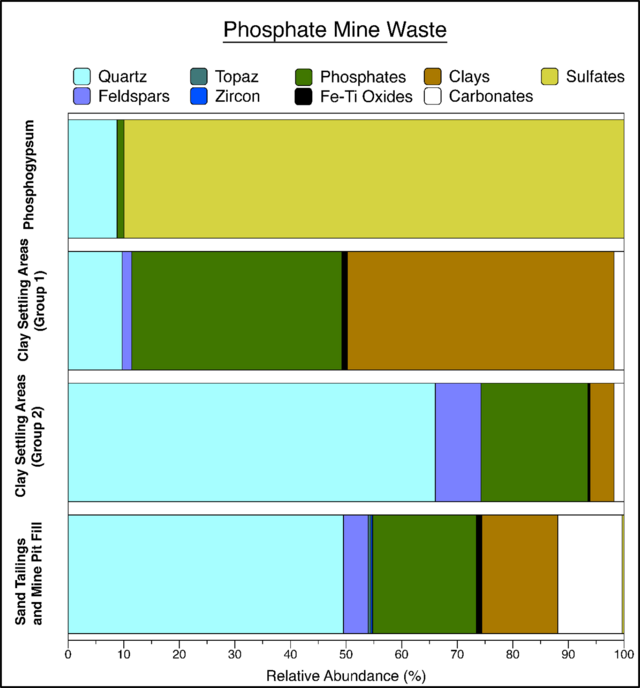 Figure 3. X-ray diffraction mineralogy results averaged for each of the waste types. Some mineral results are grouped, including feldspars (plagioclase and potassium feldspar), phosphates (apatite, wavelite, crandallite, vivianite and metavivianite), Fe-Ti oxides (hematite, rutile and anatase), clays (kaolinite, palygorsite, mica and clays of varying angstrom measurements), carbonates (calcite and dolomite-ankerite) and sulfates (gypsum, anhydrite, bassanite and meniaylovite).
The volume for every PG stack in the state of Florida was calculated using 2017 lidar data (Figure 4). Based on the average density of PG, we estimated that there are over 1.6 billion tons of PG stored in 24 stacks throughout the state of Florida as of 2017 (Fowler and Davis, 2026). Finally, the amount of REEs stored in these stacks is estimated to be 378,313 tons. Importantly, this tonnage was calculated based on the REE characterization of the Piney Point PG stack and could deviate significantly based on stack specific REE characterization.
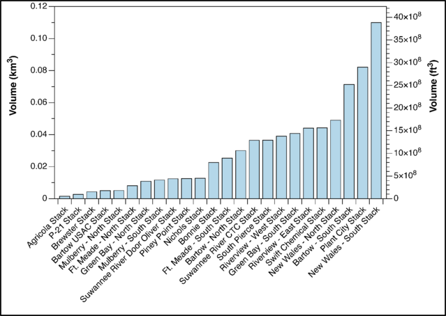 Figure 4. Phosphogypsum stack volume estimates for each stack in Florida. Volumes were estimated from 2017 lidar and do not reflect more recent additions.
References Cited
Beavers, C., Hanlon, E.A., Wilson, M., Cates, J., and Hochmuth, G.J., 2015, Sand-Clay Mix in Phosphate Mine Reclamation: Characteristics and Land Use SL423/SS636, 7/2015: Electronic Data Information Source, v. 2015, no. 8, article number 6, https://doi.org/10.32473/edis-ss636-2015.
Brown, M.T., 2005, Landscape restoration following phosphate mining: 30 years of co-evolution of science, industry and regulation: Ecological Engineering, v. 24, no. 4, p. 309–329, https://doi.org/10.1016/j.ecoleng.2005.01.014.
Fowler, G.D. III, and Davis, B.L., 2026, Florida Phosphate Mine Waste Characterization: Florida Geological Survey Report of Investigation 125, 123 p., in review.
Green, R.C., Paul, D.T., Evans, W.L., III, Scott, T.M., and Petrushak, S.B., 2006, Geologic Map of the Western Portion of the U.S.G.S. 1:100,000 scale Lake City Quadrangle, Northern Florida: Florida Geological Survey Open-File Map Series 97, scale 1:100,000, 2 pl., https://doi.org/10.35256/OFMS97.
Green, R.C., Apolinar, B., Williams, C.P., White, K.M., Bassett, S.W., and Nason, L.F., 2017, Geologic map of the U.S.G.S. Saint Petersburg 30 x 60 minute quadrangle, west central Florida [3 plates]: Florida Geological Survey Open-File Map Series 109, scale 1:100,000, 3 pl., https://doi.org/10.35256/OFMS109.
Green, R.C., Williams, C.P., Lamarche, A.G., Hebets, C.L., Albritton, C.K., and Evans, G.S., 2019, Geologic map of the USGS Bartow 30 x 60 minute quadrangle, central Florida: Florida Geological Survey Open-File Map Series 111, scale 1:100,000, 3 pl., https://doi.org/10.35256/OFMS111.
Hammarstrom, J. et al., 2020, Focus areas for data acquisition for potential domestic resources of 11 critical minerals in the conterminous United States, Hawaii, and Puerto Rico—Aluminum, cobalt, graphite, lithium, niobium, platinum-group elements, rare earth elements, tantalum, tin, titanium, and tungsten (ver. 1.1, July 2022), chap. B of U.S. Geological Survey, Focus areas for data acquisition for potential domestic sources of critical minerals: U.S. Geological Survey Open-File Report 2019–1023, 67 p., https://doi.org/10.3133/ofr20191023B.
Huddlestun, P.F., 1988, A revision of the lithostratigraphic units of the Coastal Plain of Georgia, the Miocene through Holocene: Georgia Geologic Survey Bulletin 104, 262 p., dlg_ggpd_s-ga-bn200-pg3-bb1-bno-p-b104.pdf.
Matson, G.C., 1915, The Phosphate Deposits of Florida: U.S. Geological Survey Professional Paper Bulletin 604, 101 p., https://pubs.usgs.gov/bul/0604/report.pdf.
Riggs, S.R., 1979, Phosphorite sedimentation in Florida - a model phosphogenic system: Economic Geology, v. 74, p. 285-314, https://doi.org/10.2113/gsecongeo.74.2.285.
Riggs, S.R., 1980, Intraclast and pellet phosphorite sedimentation in the Miocene of Florida: Journal of Geology, Geological Society of London, v. 137, p. 741-748, https://doi.org/10.1144/gsjgs.137.6.0741.
Riggs, S.R., 1984, Paleoceanigraphic model of Neogene phosphorite deposition, U.S. Atlantic Continental Margin: Science, v. 223, p. 123-131, https://doi.org/10.1126/science.223.4632.123.
Sellards, E.H., 1913, Origin of the hard rock phosphates of Florida, in Sellards, E.H., and Gunter, H., eds., Fifth Annual Report: Florida Geological Survey Annual Report 5, 306 p., https://doi.org/10.35256/AR05.
Sellards, E.H., 1915, The pebble phosphates of Florida, in Sellards, E.H. et al., eds., Seventh Annual Report: Florida Geological Survey Annual Report 7, 342 p., https://doi.org/10.35256/AR07.
Scott. T.M., 1988, The lithostratigraphy of the Hawthorn Group (Miocene) of Florida: Florida Geological Survey Bulletin 59, 148 p., https://doi.org/10.35256/B59.
Scott, T.M. et al., 2001, Geologic Map of the State of Florida: Florida Geological Survey Map Series 146, scale 1:750,000, https://doi.org/10.35256/MS146.
Taha, Y., Elghali, A., Hakkou, R., and Benzaazoua, M., 2021, Towards Zero Solid Waste in the Sedimentary Phosphate Industry: Challenges and Opportunities: Minerals, v. 11, no. 11, article 1250, https://doi.org/10.3390/min11111250.
U.S. Geological Survey, 2024, Annual NLCD assessment: Phosphate mining and land cover change: U.S. Department of the Interior, https://www.usgs.gov/centers/eros/news/annual-nlcd-assessment-phosphate-mining-and-land-cover-change (accessed May 2026).
Contact: Gary Fowler, PhD, PG
Suggested Citation
Fowler, G., 2026, Earth MRI: Phosphate Mine Waste Characterization: FGS News and Research Summer 2026 edition. https://content.govdelivery.com/accounts/FLDEP/bulletins/417d410#link_3.
Back to top
The FGS’s Geoscience Information and Data Management (GIDM) section oversees the management and maintenance of all the spatial data for the division. The section is dedicated to data management, and staff members oversee the collection, storage and discoverability of data. This involves locating and accrediting all geologic information from historical and current projects, and includes indexing, cataloging and authentication of data and samples in the Florida Geologic Sample Collections Facility. It is integral in all aspects of data collection, organization and visualization.
In addition to maintaining data, GIDM also creates ways to explore and interact with data, both for staff and for the public. As such, several StoryMaps have been created for the public to learn more about the geology and fossils of Florida and to provide information and interactive opportunities.
Four new StoryMaps were created in Spring 2026. These include Florida’s Geologic History; STATEMAP; State Geological Sites and State Invertebrate Paleontological Sites; and the Walter Schmidt Museum of Florida Geology.
Florida’s Geologic History StoryMap
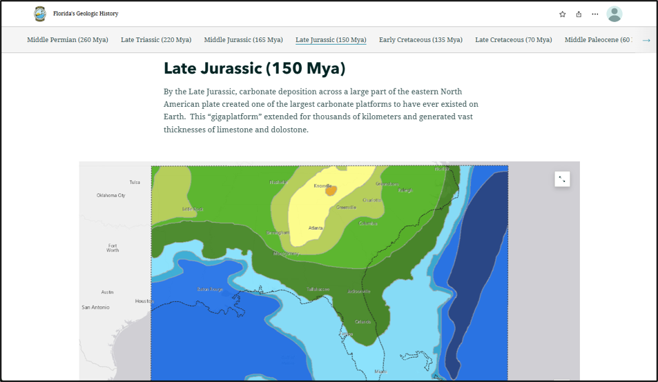
Take a virtual tour through time to explore how Florida was formed. The Florida’s Geologic History StoryMap, created by Michelle Ladle, is a visual tour of Florida’s tectonic and depositional history through geologic time (Figure 1).
The tour starts 260 million years ago and takes you through time to present day, showing the elevation of the land that would eventually create Florida. It also shows how long Florida was submerged beneath the ocean, allowing for the deposition of Florida’s carbonate platform.
Figure 1. Paleogeographic reconstruction of the Late Jurassic (150 mya) from the Florida’s Geologic History StoryMap. Each page provides a write-up explaining the time period and what is affecting the deposition of sediment in Florida. There is also a map showing the elevation at that time. Greens, yellows, and the highest elevation, orange, show the elevation on land. The blues show where ocean water is present, the deeper the shade the deeper the ocean. Click here to explore Florida’s Geologic History StoryMap.
STATEMAP StoryMap
A new version of the STATEMAP StoryMap has been created by Crystal Hebets. The Web App has been modernized and allows for more interactivity with the STATEMAP data.
The home page explains what the STATEMAP program is and gives information on the various publications available from the project (Figure 2).
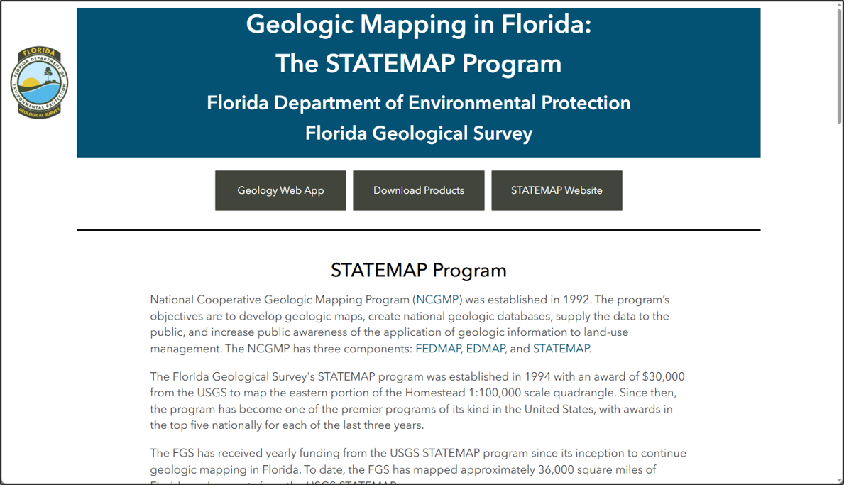 Figure 2. Home page of the STATEMAP StoryMap. Click here to explore the STATEMAP StoryMap.
The second page of this StoryMap is a Geologic Web App (Figure 3). The Web App allows users to interact with the geology mapped as part of the STATEMAP projects. You can select a formation type in the drop down to the right and it will zoom and select that formation in the map. It also will open a description of the formation in the infographic to the right. Additionally, you can explore project areas by turning on the quadrangle boundaries and can download all the STATEMAP publications.
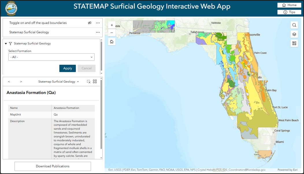 Figure 3. A page in the Geologic Web App of the STATEMAP StoryMap that allows for interactivity with the STATEMAP geology and study area layers. Click here to explore the STATEMAP StoryMap.
Intern Highlight
In Fall 2025, FSU student Greyson Kohl visited the FGS Walter Schmidt Museum of Florida Geology with the FSU Paleontology Club. After learning about internship opportunities during the visit, Greyson applied and began interning at the FGS this past Spring. Greyson’s previous experience with ArcGIS was put to good use, creating two new StoryMaps for the FGS. Explore Greyson’s work with the State Geological Sites and State Invertebrate Paleontological Sites StoryMap and the Walter Schmidt Museum of Florida Geology StoryMap below.
State Geological Sites and State Invertebrate Paleontological Sites StoryMap
Chapter 377.075 (4)(e), Florida Statutes, states that 'state geological sites' or 'state invertebrate paleontological sites,' as designated by the State Geologist, are locations of great and continuing significance to the scientific study and public understanding of the geological history of the state. There are currently nine state geological sites and one state invertebrate paleontological site.
The StoryMap gives an overview of what these sites are and then allows users to scroll through a map tour of all sites, with more information and images about each location (Figure 4).
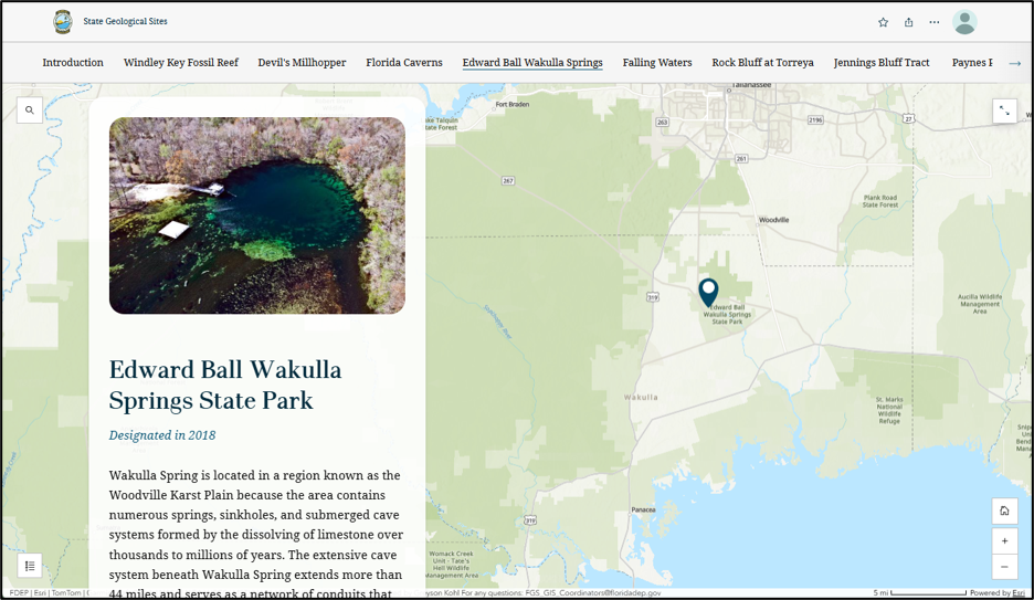 Figure 4. State Geological Sites StoryMap includes a map tour of the nine state geological sites and one state invertebrate paleontological site across Florida. Figure shows the Edward Ball Wakulla Springs State Park slide. Click here to explore the State Geological Sites and State Invertebrate Paleontological Sites StoryMap.
Walter Schmidt Museum of Florida Geology StoryMap
The Walter Schmidt Museum of Florida Geology is the FGS’s in-house museum with fossil, rock and mineral specimens from around the state of Florida on display. The museum StoryMap explains the museum layout and contents and allows users to scroll through highlights from the museum. These highlights show images and descriptions of selected notable specimens on display that are found throughout the state. Each of these highlights are exhibit pieces found in the museum, like Waller’s Terror Bird (Figure 5) and calcite mineral specimens (Figure 6). We currently highlight 14 specimens within the StoryMap.
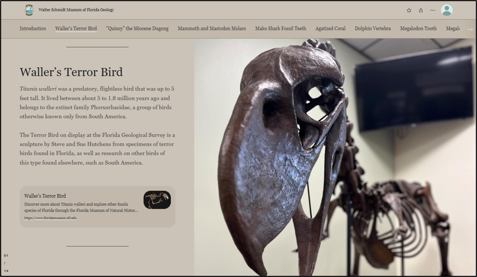 Figure 5. The Walter Schmidt Museum of Florida Geology StoryMap includes 14 highlighted specimens, including Waller’s Terror Bird, as pictured above, and includes an explanation of the specimen as well as links to more information. Click here to explore the Walter Schmidt Museum of Florida Geology StoryMap.
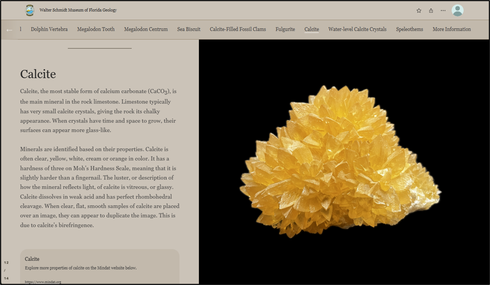 Figure 6. The Walter Schmidt Museum of Florida Geology StoryMap includes 14 highlighted specimens, including the Calcite slide above. Click here to explore the Walter Schmidt Museum of Florida Geology StoryMap.
Contact: Crystal Hebets
Suggested Citation
Hebets, C., 2026, Geologic Stories: Web Apps with Purpose: FGS News and Research Winter 2026 edition. https://content.govdelivery.com/accounts/FLDEP/bulletins/417d410#link_4.
Back to top
|