|
Welcome to the Winter 2026 edition of the Florida Geological Survey (FGS) News and Research. Fall of 2025 was a productive time at the FGS for both research and outreach activities. The FGS was awarded several cooperatively funded federal grants from the U.S. Geological Survey to continue our surficial geologic mapping efforts. We also conducted a groundwater dye trace study and participated in and led field trips in the Florida Panhandle. Collaboration with the Florida Museum of Natural History (FLMNH) resulted in the transfer and curation of a large collection of FGS micropaleontological specimens that are now housed at the FLMNH and the development of our newest museum exhibit at FGS featuring the megalodon shark. In October, we hosted our annual open house and showcased our newly printed and painted 3D fossil replicas.
I am also pleased to report that the FGS partnered with The Nature Conservancy to designate Alum Bluff as Florida’s first State Invertebrate Paleontological Site and ninth State Geological Site. State Invertebrate Paleontological Sites are designated to protect areas containing invertebrate fossils that are rare, unique, exceptionally preserved or of special importance. Alum Bluff, the tallest natural exposure in Florida, is a cutbank on the east side of the Apalachicola River. Here four geologic strata containing extremely diverse and well-preserved fossil assemblages are exposed. This site, first noted in scientific literature in the 1880s, continues to be of importance to geologists as we interpret Florida’s geologic history over the past 18 million years. See our FGS News section below for more information about our recent events. Also, take a look back at images from the early 1900s documenting initial FGS investigations.
In celebration of this designation, we focus this issue of the FGS News and Research on the geology and features of the Apalachicola Delta District. Located along the Apalachicola River in the south-central Florida Panhandle, this district is dominated by fluvial features, such as eroded riverbanks, sand bar deposits and floodplains. The surficial geology in the Apalachicola Delta District is predominately comprised of a thick layer of quartz-rich sand and clay deposited by stream systems. Limestone is more deeply buried in this area and, as a result, karst features are uncommon. Over geologic time, the sediment deposited by streams was modified by coastal processes, resulting in the beaches and barrier islands we enjoy today in places like Dr. Julian G. Bruce St. George Island State Park. We use techniques like ground-penetrating radar to analyze the subsurface geology without the need for borehole samples and reconstruct the processes that formed these islands.
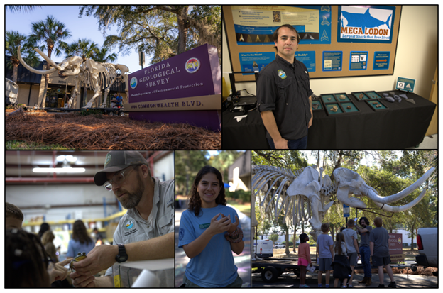
Many of Florida’s sedimentary deposits, like those exposed at Alum Bluff, contain an abundance of fossils. To highlight this, “Exploring Florida Fossils” was the theme of our open house this fall. The FLMNH donated cases and interpretative material for our newest Megalodon exhibit. In Megalodon: Extinct Apex Predator of the Ocean, read about this 60-foot-long extinct shark and see photos of the fossils of megalodon and its prey on display at the FGS.
Florida’s geology is diverse and profoundly influences the lives of our citizens and visitors. We provide critical geoscience information and data that are used to ensure public safety, economic prosperity and sustainability of our environmental resources. The work we do is important and exciting and I hope you enjoy reading about it in this issue. Thank you for your continued support of our organization.
Sincerely,
Guy H. Means
Director and State Geologist
Florida Geological Survey
Florida Department of Environmental Protection
In this issue...

Alum Bluff Designated as Florida’s First State Invertebrate Paleontological Site and Ninth State Geological Site
Alum Bluff is now Florida’s first designated State Invertebrate Paleontological Site and ninth State Geological Site. On Saturday, Oct. 18, 2025, State Geologist Harley Means presented The Nature Conservancy’s Apalachicola Bluffs and Ravines Preserve Manager Cathy Ricketts with the designation plaque. The ceremony drew notable guests, including Executive Director of the Nature Conservancy in Florida Greg Knecht, Florida Museum of Natural History (FLMNH) Invertebrate Paleontology Collections Director Roger Portell and Dr. Bruce Means, whose pioneering work on steepheads influenced the early push for site conservation. For more information, please read Alum Bluff: Florida’s First State Invertebrate Paleontological Site in this newsletter, and scroll to minute 26 in the video stream from the Florida Channel.
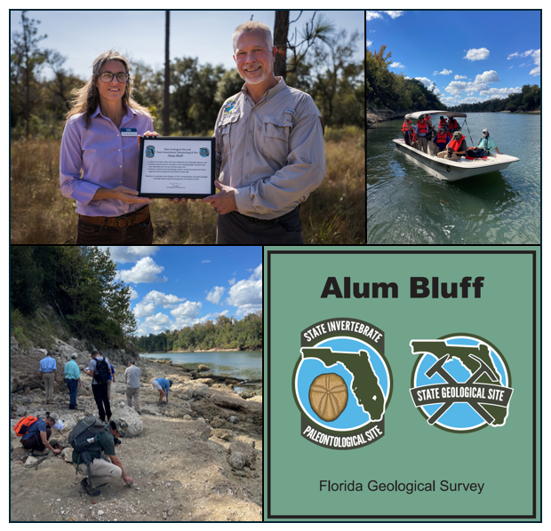 |
Figure 1. Alum Bluff designation ceremony and outing. Top left: The Nature Conservancy’s Apalachicola Bluffs and Ravines Preserve Manager Cathy Ricketts (left) accepts a designation plaque from State Geologist Harley Means (right). Top right: After the dedication ceremony, participants toured Alum Bluff by boat. Bottom left: Cathy Ricketts (left) and WFSU’s Rob Diaz de Villegas (right) kneel to examine fossils of the Chipola Formation with other outing participants. Bottom right: Visitors can see Alum Bluff by boat, or by hiking the Garden of Eden Trail through The Nature Conservancy’s Apalachicola Bluffs and Ravines Preserve. This sign, posted at the trailhead, commemorates the site’s designation.
FGS Leads Field Trips to Alum Bluff
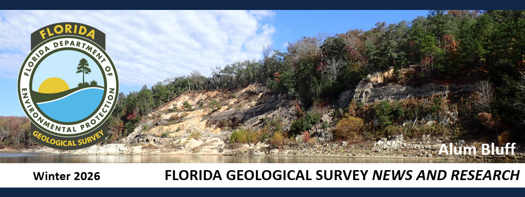
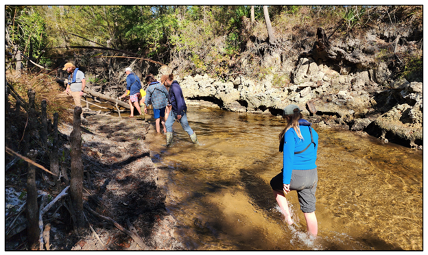
FGS geologists led field trips for the Florida Paleontological Society (FPS), WFSU reporter Rob Diaz de Villegas, and Florida State University (FSU) Researcher Maya Stokes and her students to Alum Bluff. During the FPS trip, the group found and preserved an impressive fossil palm frond, which Roger Portell (front, center) deposited into the collection at the (FLMNH).
Figure 2. Florida Paleontological Society visited Alum Bluff and preserved an impressive fossil palm frond.
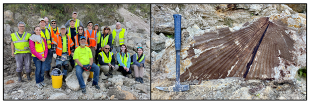
Tracing the Flow of Groundwater
The Applied Geosciences Services Section of the FGS recently conducted a groundwater dye trace to identify recharge points and delineate general groundwater flow paths in the Floridan aquifer system. The study area encompassed portions of Leon, Wakulla and Jefferson counties. On May 21 and 22, 2025, nontoxic dyes were introduced into two swallets north of the Cody Escarpment. Sample sites in the Wakulla, St. Marks, Wacissa and Aucilla groundwater basins were monitored from May 19 to July 22, 2025. Dye was detected at several sample sites throughout the study area and provided insight on groundwater travel time and the contribution areas of the springsheds monitored. The FGS will publish a report of investigation detailing the results of the study.
Figure 3. Swallet after dye introduction in Creek Sink.
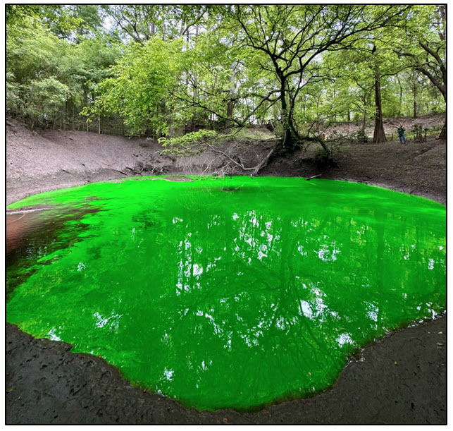
FGS Contributes to the Micropaleontology Collection at the Florida Museum of Natural History
The FLMNH recently received and curated a large collection of micropaleontological specimens provided by the FGS. This December, Jonathan Bryan and Roger Portell published a paper about the University of Florida’s Micropaleontology Collection in the Revue de Micropaléontologie, with special mention of the large donation by the FGS. This scientifically important collection is now permanently housed at the FLMNH, where it is accessible for scientific study through request.
Figure 4. The Revue de Micropaléontologie recently published the above article, “Micropaleontology at the Florida Museum of Natural History, University of Florida.” The article includes the above images of microfossil slides donated by the FGS.
FGS Receives Cooperatively Funded Federal Grants
The FGS was recently awarded the following cooperatively funded federal grants from the U.S. Geological Survey (USGS):
-
STATEMAP: New Geologic Mapping of the Miami and Everglades City 30 x 60 quadrangles was funded for a total of $1,115,458 over two years (cooperatively funded state/USGS $557,729).
-
Earth Mapping Resources Initiative (Earth MRI): The USGS awarded the FGS $3,000 in travel funds for project principal investigators to attend the Earth MRI Workshop in Reston, Virginia.
-
National Geological and Geophysical Data Preservation Program (NGGDPP): Under Priority 3 (Critical Minerals Data Preservation), funding to support “Florida Geological Survey Critical Mineral Sample Data Preservation” was awarded by the USGS to cover the cost of geochemical analyses on up to 300 rock and sediment samples. Samples will be analyzed at various USGS facilities depending on techniques and methods performed.
FGS Geologist Field Training
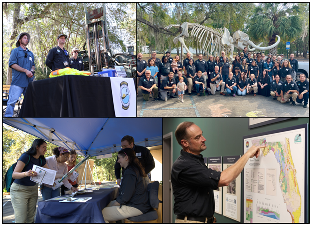
In November, 12 FGS geologists visited the northern Florida Panhandle to examine the region’s surficial geologic units, geologic type-sections, geomorphology, hydrologic and hydrogeologic features. This trip was the second in a series of Panhandle field training trips. These field training outings provide FGS geologists with first-hand opportunities to explore important geologic exposures and gain familiarity with formations and features occurring throughout the state, allowing our staff geologists to be knowledgeable about the geology of the entire state.
Figure 5. FGS geologists explore limestone outcrops along the Chipola River.
FGS Open House
“Exploring Florida Fossils” was the theme for the 2025 FGS open house, at which we showcased fossils from two of the largest vertebrates to swim or walk across Florida’s paleo landscape. We highlighted a cast of the mastodon found in the Little River section of the Aucilla River and various fossils from megalodon sharks. Technology and applications associated with 3D imagery were also highlighted at the 2025 FGS open house. FGS staff educated visitors about the use of 3D mapping to understand offshore landforms, using Legos to help children visualize the process. FSU’s Innovation Hub donated 3D printed fossils, as did FGS geologist Nick Hall, who also painted the 3D printed fossils.
We welcomed 256 visitors, including students from the Rose Academy, the STEM group from Maclay School, interns and externs from Conservation Pathways and FSU’s Department of Earth, Ocean and Atmospheric Science (EOAS) students. Partners represented at the event included educators from Joe Budd Youth Conservation Center, Lake Jackson Aquatic Preserve and the Aucilla Research Institute.
Figure 6. The 2025 FGS open house theme was “Exploring Florida Fossils.” Top left: The Aucilla Research Institute brought “Priscilla the Mastodon.” Top right: Nick Hall 3D printed and painted megalodon fossils from Florida for visitors to touch. The 3D models were displayed beside the original fossils, which were protected by cases. Bottom left: Visitors to the Lake Jackson Aquatic Preserve station examined a frog. Bottom middle: A corn snake greeted visitors to the Joe Budd Youth Conservation Center station. Bottom right: Students and educators from Rose Academy learned about fossil mastodons.
Figure 7. All hands were on deck to greet visitors. Top left: FGS Drillers Jesse Hurd, Nick Bloodworth and Brandon Reese showed off the drill rig. Top right: 2025 FGS team. Bottom left: Katy Etheridge and Ethan Roberts share FGS publications with FSU students. Bottom right: Clint Kromhout points out the location of State Geological Sites on the Geologic Map of the State of Florida.
Recently Released FGS Publications
Fowler, G.D., III, and Lupo, M.E., 2025, Potentiometric Surface of the Upper Floridan Aquifer May 2022: Florida Geological Survey Map Series 166, scale 1:900,000, https://doi.org/10.35256/MS166.
Fowler, G.D., III, and Lupo, M.E., 2025, Potentiometric Surface of the Upper Floridan Aquifer September 2022: Florida Geological Survey Map Series 167, scale 1:900,000, https://doi.org/10.35256/MS167.
A Look Back: Alum Bluff throughout American History
This year commemorates the 250th anniversary of America. Recently, our geologists were excited to recognize Alum Bluff as a state geological site and Florida’s first invertebrate paleontological site. This excitement for Alum Bluff is not a new phenomenon though. For more than a century, Alum Bluff has been a place of fascination for Floridians. Among those drawn to its significance was Julia Gardner, whose scientific publications about Alum Bluff spanned more than two decades and document some of the most diverse and well-preserved fossil molluscan faunas in the world. In addition to her scholarly work, she served the U.S. in World War I and World War II. In France during World War I, she served as a nurse, including with the ambulance service. In World War II she served in the “Dungeon Gang” of the Military Geology Unit of the USGS, identifying sediments used as ballasts to pinpoint the location from which balloon bombs were launched. Learn more about Julia Gardner and other pioneering women in the field of paleontology in the Daring to Dig: Women in American Paleontology exhibit.
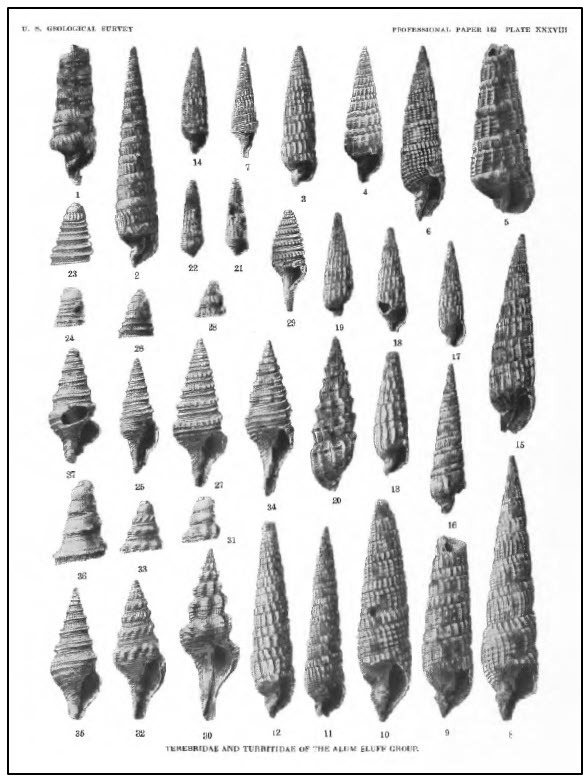 |
Figure 8. Julia Gardner documented and described more than 800 species of mollusks at Alum Bluff. This image is from her 1937 USGS Publication, “The Molluscan Fauna of the Alum Bluff Group of Florida, Part VI. Pteropoda, Opisthobranchia, and Ctenobranchia (in Part).”
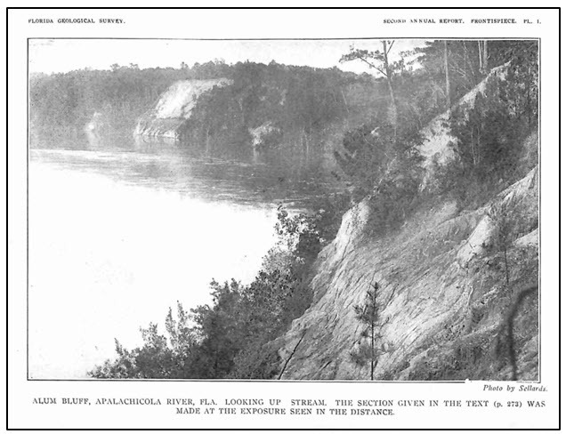
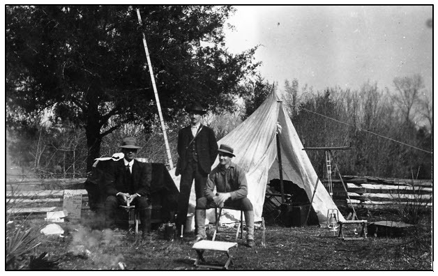
Figure 9. One of the earliest photographs taken of Alum Bluff. The photo was taken by Dr. E.H. Sellards, the first Florida State Geologist. The image appears in the FGS’s second annual report published in 1909.
Figure 10. Conducting field work in the early 20th century had to have been challenging. However, the FGS field crew were well dressed for the occasion! This photo was taken at Aspalaga Landing on the Apalachicola River in 1909. The scientists in the photo are, from left to right, Dr. E.H. Sellards (Florida’s first State Geologist), Roland Harper and Herman Gunter (Florida’s second State Geologist).
Contact: Mabry Gaboardi Calhoun, Ph.D.
Back to top

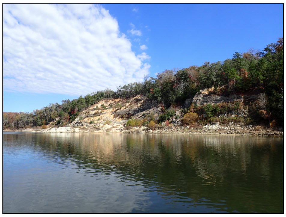
Alum Bluff is Florida’s first State Invertebrate Paleontological Site, designated on Oct. 18, 2025. With approximately 125 feet of vertical exposure observable during low stages of the Apalachicola River, it is the tallest natural exposure in Florida and the only location in Florida with four geologic units exposed (Figure 1). Named for the iron sulfide mineral pyrite present in minor amounts within the eroding sediments, Alum Bluff has been studied since the 1880s (e.g., Langdon, 1889; Dall and Harris, 1892; Dall and Stanley-Brown, 1893; Matson and Clapp, 1909). Scientific publications spanning more than a century document some of the most diverse and well-preserved fossil molluscan faunas in the world (e.g., Gardner, 1926; Gardner, 1947; Vokes, 1989) and rarely preserved glimpses into Miocene plant communities (Berry, 1916; Lott et al., 2019).
Figure 1. Alum Bluff on the Apalachicola River.
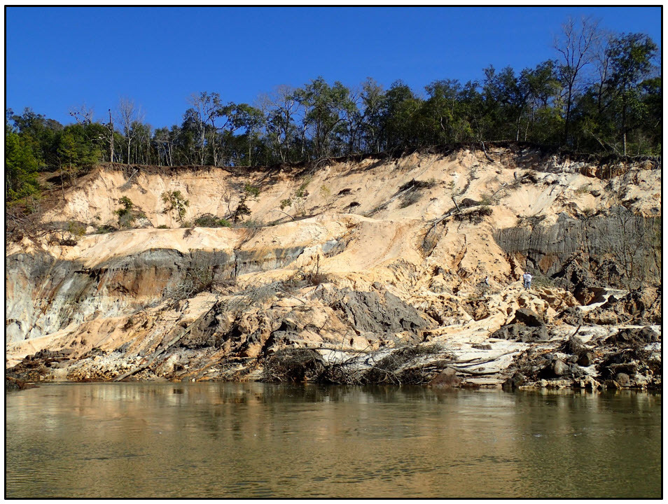
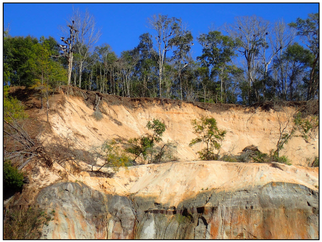
Located on the east side of the Apalachicola River, about 2 miles north of the town of Bristol in Liberty County, Florida, Alum Bluff is a steep cutbank eroded into fossiliferous limestone, sand, silt and clay (Figure 2). It is accessible directly from the Apalachicola River by boat, or over land through The Nature Conservancy’s Apalachicola Bluffs and Ravines Preserve, along the Garden of Eden trail. As hiking from the trail down the bluff is not permitted, Alum Bluff is best observed by boat. Naturally occurring erosion of sediment continually reshapes the bluff, with occasional dramatic mass wasting events. A medium-magnitude landslide, documented by Mossa and Chen (2025), occurred at the bluff between 2013 and 2015, resulting in about 100,000 tons of sediment lost from the upper portion of the bluff (Figure 3).
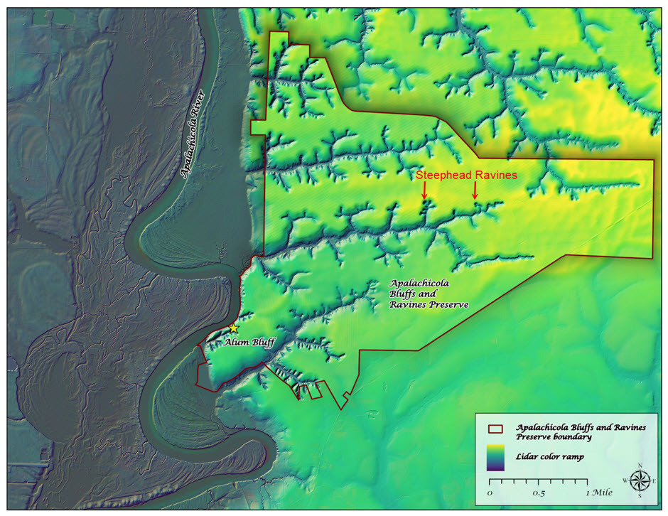 |
Figure 2. Lidar image showing the location of Alum Bluff, a steep cutbank on the east side of the Apalachicola River. Note the high topography on the east side of the river, contrasting sharply with the lower floodplain sediments of the Apalachicola River. Steephead ravines, developed in the sands of the Citronelle Formation, can be seen eroding headward as water flows toward the river.
Figure 3. Landslide at Alum Bluff.
The Apalachicola River, which erodes into Alum Bluff, is the largest river in Florida by volume. It is the only river in Florida with a tributary that has headwaters in the southern Appalachian Mountains. The Apalachicola River begins at the Florida state line, near the confluence of the Flint and Chattahoochee rivers. From the Jim Woodruff Dam, which creates Lake Seminole, the Apalachicola River flows approximately 106 miles from the state line to the Apalachicola Bay. The watershed, called the Apalachicola-Chattahoochee-Flint (ACF) River Basin, begins north of Atlanta and drains to Apalachicola Bay.
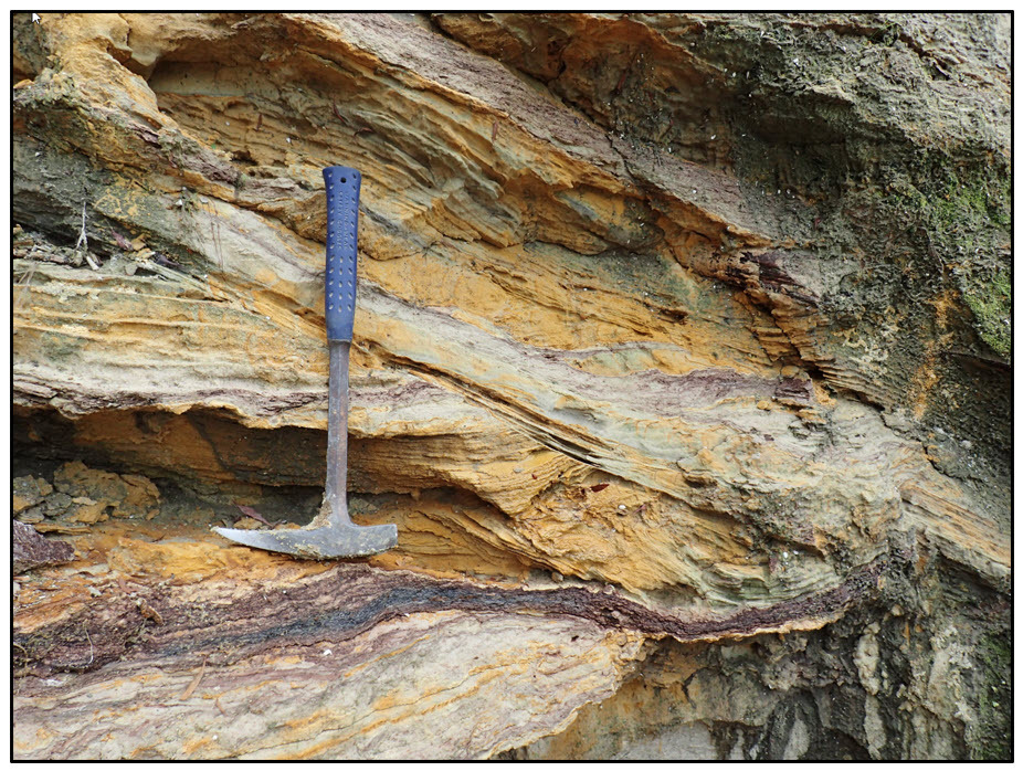
Many authors have described the strata at Alum Bluff, with previous literature summarized by Schmidt (1983; 1984; 1986). While the strata themselves have not changed, scientific understanding of how these strata fit into regional correlations has evolved. Because of our improved understanding, the stratigraphic nomenclature has been updated several times (e.g., DuBar and Beardsley, 1961; Schmidt, 1983; Bryant et al., 1992; Means, 2002; Bryan et al., 2014). The FGS currently recognizes four strata exposed at the site that include the early Miocene Chipola formation (Puri and Vernon, 1964), undifferentiated Alum Bluff Group, late Pliocene Jackson Bluff Formation (Puri and Vernon, 1964), and late Pliocene to early Pleistocene Citronelle Formation (Matson, 1916). The uppermost soil and sand are reworked Quaternary sediments (Figure 4). As a sedimentary package, these geologic units record a series of sea level changes, with environments of deposition ranging from nearshore marine to fluviodeltaic.
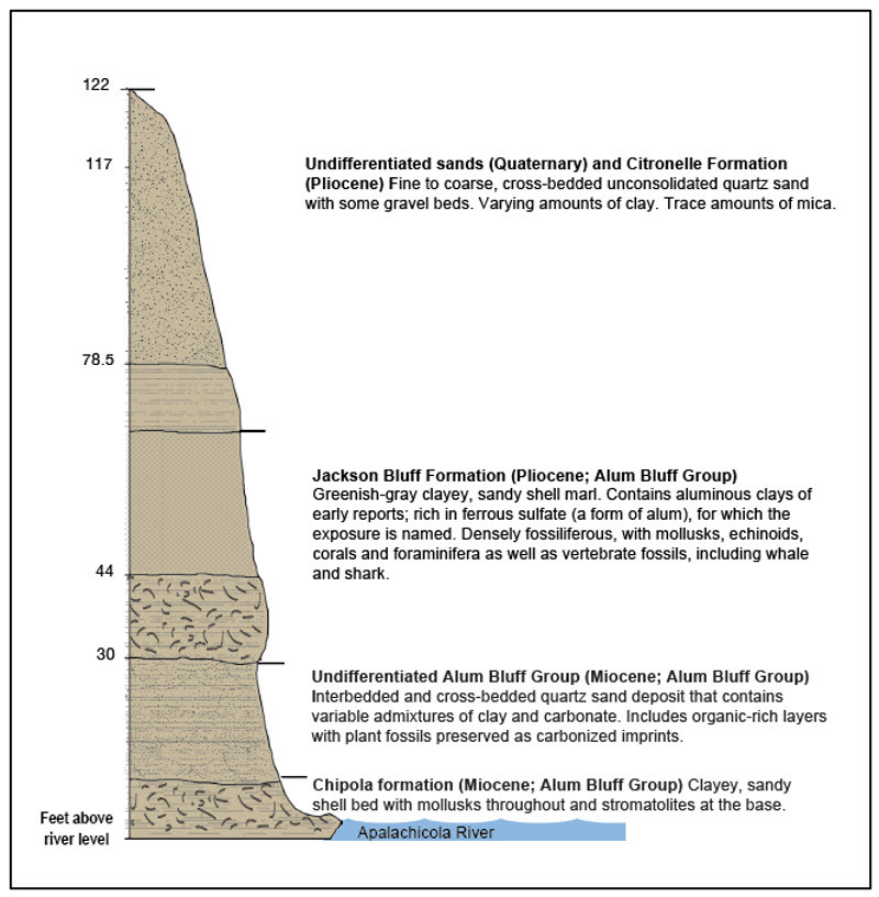 |
Figure 4. Stratigraphy of Alum Bluff. Note that the Chipola formation is an informal unit name, and therefore “formation” is not capitalized (modified from Bryan et al., 2014).
The Chipola formation (Puri and Vernon, 1964) exposed at Alum Bluff ranges from a clayey, sandy marine shell bed to a highly fossiliferous sandy limestone (Figure 5; Schmidt, 1984; Johnson, 1989). Originally recorded in the 1889 field notes of USGS geologist Frank Burns as the Chipola marl, this unit is lithologically variable and has often been recognized based on biostratigraphy due to the abundance and preservation of mollusks within the unit (Gardner, 1926; Gardner, 1947). For this reason, some authors suggest that it not be considered a formalized unit (Johnson, 1989). According to the North American Stratigraphic Code, “formation” is not capitalized in an informal unit name. Current stratigraphic nomenclature places the Chipola formation at the base of the Alum Bluff Group.
Figure 5. Sandy marine shell bed within the Chipola formation.
Stromatolites occur in the basal portion of the Chipola formation exposed at Alum Bluff (Figure 6; Bryan et al., 2016). Stromatolites are trace fossils that result when sediment is trapped by cyanobacteria and blue green algae. Although commonly found in sedimentary rocks more than a billion years old, they are rarely found in Cenozoic strata deposited during the last 65 million years. Stromatolites in the Chipola formation formed at the mouth of the Gulf Trough, a channel that existed across north Florida and south Georgia and filled in during the Miocene. The molluscan fauna of the Chipola formation has been widely studied (Gardner, 1947) and is thought to contain more than 1,100 different species (Vokes, 1989). When the Chipola formation was deposited, sea level was higher than today, and this fauna likely records the last time that northern Florida experienced a tropical climate. Based on biostratigraphic correlations and strontium isotopic dating of mollusks, the Chipola was likely deposited during the early Miocene, 18.3-18.9 million years ago (mya; Bryant et al., 1992).
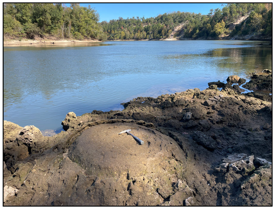 |
Figure 6. Stromatolite in the basal portion of the Chipola formation on the Apalachicola River. Alum Bluff is in the background.
The undifferentiated Alum Bluff Group lies above the Chipola formation, with an unconformity separating the two units. Widely known for its plant fossils, including Sabalites apalachicolensis (Figure 7; Berry, 1916), the undifferentiated Alum Bluff Group is an interbedded and cross-bedded quartz sand deposit (Figure 8). It contains variable admixtures of clay and carbonate and includes organic-rich layers with plant macrofossils preserved as carbonized imprints. Based on correlations using vertebrate fossils, rare in this unit, Bryant et al. (1992) interpret this deposit to be of late early or early middle Miocene age. At that time, 15 mya, the ecosystem at Alum Bluff was likely a temperate “elm-hickory-cabbage palm forest” (Lott et al., 2019, p. 75), similar to the Florida’s Big Bend region today. The undifferentiated Alum Bluff Group contains more carbonate at the base and less toward the top, recording a lowering of sea level over the time of deposition, and cooler temperatures than the underlying Chipola formation.
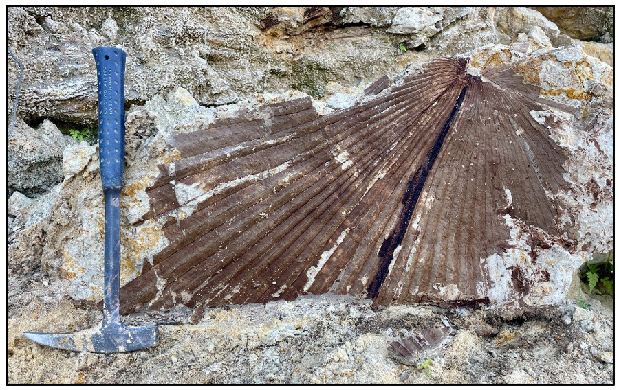 |
Figure 7. Sabalites apalachicolensis (Berry, 1916) in the undifferentiated Alum Bluff Group.
Figure 8. Cross-beds in the undifferentiated Alum Bluff Group.
The Jackson Bluff Formation was designated by Puri and Vernon (1964) by combining two previously described fossil-rich zones (Ecphora and Cancellaria faunal zones) that crop out at Jackson Bluff on the Ochlocknee River in Leon County. Lithologically, it is a greenish-gray fossiliferous sandy clay to clayey sand. DuBar and Beardsley (1961) describe the Jackson Bluff Formation as it appears at Alum Bluff, though they refer to it at that time as the “Choctawhatchee formation.” They describe the “Ecphora facies” unconformably overlying the undifferentiated Alum Bluff Group as a greenish-gray clayey, sandy shell marl (p. 162-163).
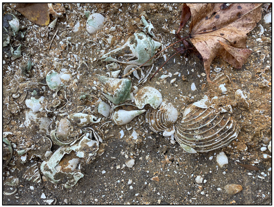
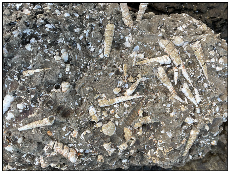
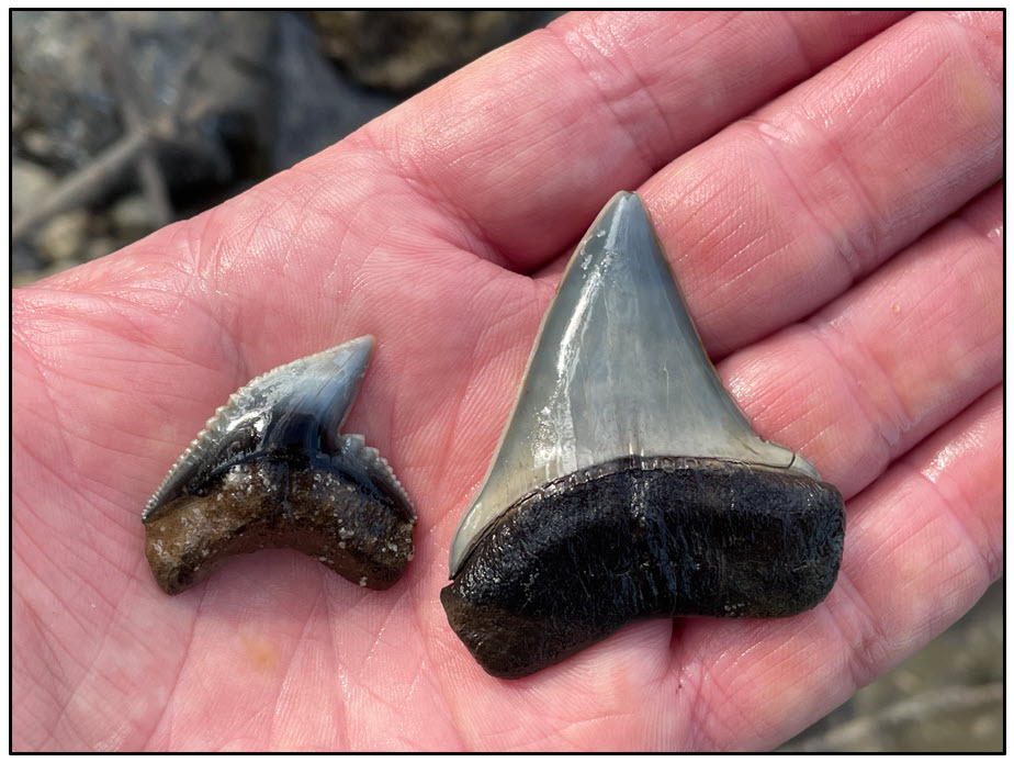
More than 200 fossil molluscan species are recognized in the Jackson Bluff Formation, along with other marine invertebrates, like echinoids, corals and foraminifera (Figure 9). Marine vertebrate fossils in the unit include whales, dugongs and sharks (Figure 10), occasionally including teeth from Otodus megalodon. Based on the fossil assemblege, the unit was deposited in the late Pliocene, between 3.6 to 2.58 mya (Akers,1972), when sea level was higher than today, in a nearshore estuarine environment.
Figure 9. Marine invertebrate fossils from the Jackson Bluff Formation at Alum Bluff.
Figure 10. Fossil shark teeth found in the Jackson Bluff Formation at Alum Bluff.
The Citronelle Formation (Matson, 1916) is a fine to coarse quartz sand with some quartz pebbles and varying amounts of reddish clay. This unit was likely deposited in a fluvial environment during the late Pliocene or early Pleistocene (Isphording and Lamb, 1971; Rupert, 1990; Means, 2009). Unlike the lower three units, the Citronelle Formation at Alum Bluff is not fossiliferous (Figure 11). The sand of the Citronelle blankets much of the Gulf Coastal Plain, from Texas into the Florida Panhandle. In Gadsden County, to the east of Alum Bluff, the Citronelle grades laterally into the Miccosukee Formation, a more clay-rich unit. Overlying the Citronelle Formation are undifferentiated quartz sands of Quaternary age that are likely reworked from the Citronelle Formation.
Figure 11. The Citronelle Formation at Alum Bluff.
Alum Bluff is located within the geomorphic Upper Delta Province of the Apalachicola Delta District, which includes some of the greatest topographic relief in the state (Williams et al., 2022). This area has few karst features, as the underlying limestone is blanketed by thick quartz sand and clay layers deposited by river systems. Much of the topographic relief is due to ravines that develop as water flows over and through sediment. A rare type of ravine, called a steephead ravine, can be seen in Figure 2. In most ravines, water runs over the surface of the land, forming streams that erode downward from the land surface. In steephead ravines, water discharges diffusely through a seepage spring and erodes the sediment in a headward direction (Means, 1991). This happens when highly permeable sand overlies low permeability clay, which does not allow water to pass through it easily. Steepheads, like those near Alum Bluff, form as groundwater percolates downward through the thick sand of the Citronelle Formation and is stopped when it reaches underlying clay of the Jackson Bluff Formation. Instead of continuing downward, the groundwater is diverted along the contact with the clay and flows west to the Apalachicola River. This flow pattern results in headward-eroding streams and steep-walled steephead ravines. Along the Apalachicola River, the steepheads are of scientific interest because they harbor unique, relict flora and fauna that are hold-overs from the last glacial advance.
Alum Bluff, with four geologic strata exposed, is an ideal site for exploring the paleoenvironments of north Florida over the last 19 million years. These units document several transitions: 1-the higher sea levels and tropical conditions of the early Miocene Chipola formation, 2-the temperate terrestrial deposits of the undifferentiated Alum Bluff Group recording lowering sea levels of the middle Miocene, 3-higher sea levels and nearshore environments of the late Pliocene Jackson Bluff Formation and 4-terrestrial fluvial late Pliocene to early Pleistocene Citronelle Formation deposits, indicating lower sea levels once again. Fossils within these units, including stromatolites, mollusks, sabal palm fronds and shark teeth, highlight the diverse ecosystems that existed in north Florida.
References Cited
Akers, W. H., 1972, Planktonic Foraminifera and Biostratigraphy of Some Neogene Formations, Northern Florida and Atlantic Coastal Plain: Tulane Studies in Geology and Paleontology, v. 9, 140 p., https://journals.tulane.edu/tsgp/article/view/573.
Berry, E.W., 1916, The physical conditions and age indicated by the flora of the Alum Bluff Formation: U.S. Geological Survey Professional Paper 98–E, p. 41–59, https://doi.org/10.3133/pp98E.
Bryan, J.R., Means, G.H., and Portell, R.W., 2016, Large, shallow subtidal stromatolites in the Lower Miocene Chipola Formation, Alum Bluff, Liberty County, Florida: Southeastern Geology, v. 52, no. 2, p. 79-201.
Bryan, J.R., Scott, T.M., and Means, G.H., 2014, Roadside Geology of Florida: Missoula, Montana, Mountain Press, 376 p.
Bryant, J.D., MacFadden, B.J., and Mueller, P.A., 1992, Improved chronologic resolution of the Hawthorn and the Alum Bluff Groups in northern Florida: Implications for Miocene chronostratigraphy: Geological Society of America Bulletin, v. 104, no. 2, p. 208–218, https://doi.org/10.1130/0016-7606(1992)104%3C0208:ICROTH%3E2.3.CO;2.
Dall W.H., and Harris G.D., 1892, Correlation papers: Neocene: U.S. Geological Survey Bulletin 84, 349 p., https://doi.org/10.3133/b84.
Dall, W.H., and Stanley-Brown, J., 1893, Cenozoic geology along the Apalachicola River: Geological Society of America Bulletin, v. 5, p. 147-170, https://doi.org/10.1130/GSAB-5-147.
DuBar, J.R., and Beardsley, D.W., 1961, Paleoecology of the Choctawhatchee deposits (Late Miocene) at Alum Bluff, Florida: Southeastern Geology, v. 2, no. 3, p.155–189.
Gardner, J.A., 1926, The molluscan fauna of the Alum Bluff Group of Florida: Part I. Prionodesmacea and Anomalodesmacea: U.S. Geological Survey Professional Paper 142-A, 79 p., https://doi.org/10.3133/pp142A.
Gardner, J.A., 1947, The molluscan fauna of the Alum Bluff Group of Florida: U.S. Geological Survey Professional Paper 142, 709 p.
Isphording, W.C., and Lamb, G.M., 1971, Age and origin of the Citronelle Formation in Alabama: Geological Society of America Bulletin, v. 82, no. 3, p. 775-780, https://doi.org/10.1130/0016-7606(1971)82[775:AAOOTC]2.0.CO;2.
Johnson, R.A., 1989, Geologic Descriptions of Selected Exposures in Florida: Florida Geological Survey Special Publication 30, 175 p., https://doi.org/10.35256/SP30.
Langdon, D.W., 1889, Some Florida Miocene: American Journal of Science, v. 3, no. 226, p. 322-324, https://doi.org/10.2475/ajs.s3-38.226.322.
Lott, T.A., Manchester, S.R., and Corbett, S.L., 2019, The Miocene flora of Alum Bluff, Liberty County, Florida: Acta Palaeobotanica, v. 59, no. 1, p.75–129, https://doi.org/10.2478/acpa-2019-0003.
Matson, G.C., 1916, The Pliocene Citronelle Formation of the Gulf Coastal Plain: U.S. Geological Survey Professional Paper 98-L, p. 167-192, https://doi.org/10.3133/pp98L.
Matson, G.C., and Clapp, F.G., 1909, A preliminary report on the geology of Florida, in Sellards, E.H., Matson, G.C., Clapp, F.G., Sanford, S., and Gunter, H., eds., Second Annual Report, 1908-09: Florida Geological Survey Annual Report 2, p. 28-173, https://doi.org/10.35256/AR02.
Means, D.B., 1991, Florida’s steepheads: Unique canyonlands: Florida Wildlife, v. 45, no. 3, p. 25-28, https://archive.org/details/floridawildlife06-1991/page/24/mode/2up.
Means, G.H., 2002, Introduction to the Geology of the Upper Apalachicola River Basin, in Southeastern Geological Society, eds., Geologic Exposures Along the Upper Apalachicola River: Tallahassee, Florida, Southeastern Geological Society Guidebook 42, p. 4-19, https://segs.org/wp-content/uploads/2012/04/SEGS-Guidebook-42.pdf.
Means, G.H., 2009, Marine-influenced siliciclastic unit (Citronelle Formation) in Western Panhandle Florida [Master’s thesis]: Tallahassee, Florida State University, 134 p.
Mossa, J., and Chen, Y.H., 2025, Landslide at the River’s Edge: Alum Bluff, Apalachicola River, Florida: Geosciences, v. 15, no. 4, 130, https://doi.org/10.3390/geosciences15040130.
Puri, H.S., and Vernon, R.O., 1964, Summary of the Geology of Florida and a Guidebook to the Classic Exposures: Florida Geological Survey Special Publication 5 (Revised), 312 p., 11 pl., https://doi.org/10.35256/SP05R.
Rupert, F.R., 1990, Geology of Gadsden County, Florida: Florida Geological Survey Bulletin 62, 61 p., https://doi.org/10.35256/B62.
Schmidt, W., 1983, Cenozoic geology of the Apalachicola River area Northwest Florida: Southeastern Geological Society Guidebook 25, 95 p., https://segs.org/wp-content/uploads/2010/01/SEGS-Guidebook-25.pdf.
Schmidt, W., 1984, Neogene Stratigraphy and Geologic History of the Apalachicola Embayment: Florida Geological Survey Bulletin 58, 146 p., 6 pl., https://doi.org/10.35256/B58.
Schmidt, W., 1986, Alum Bluff, Liberty County, Florida, in Neathery, T.L., ed., Southeastern Section of the Geological Society of America: Geological Society of America’s Decade of North American Geology Centennial Field Guide v. 6, p. 355–357, https://doi.org/10.1130/0-8137-5406-2.355.
Vokes, E.H., 1989, An overview of the Chipola formation, northwest Florida: Tulane Studies in Geology and Paleontology, v. 22, no. 1, p. 13 – 24, https://journals.tulane.edu/tsgp/article/view/917.
Williams, C.P., Scott, T.M., and Upchurch, S.B., 2022, Florida Geomorphology Atlas: Florida Geological Survey Special Publication 59, 238 p., https://doi.org/10.35256/SP59.
Contact: Harley Means, P.G. and Mabry Gaboardi Calhoun, Ph.D.
Suggested Citation: Gaboardi Calhoun, M.M., and Means, G.H., Alum Bluff: Florida’s First State Invertebrate Paleontological Site: FGS News and Research July 2025 edition. https://content.govdelivery.com/accounts/FLDEP/bulletins/4067725#link_1.
Back to top
Dr. Julian G. Bruce St. George Island State Park, located in the Florida Panhandle on the eastern end of St. George Island, provides visitors an opportunity to explore a relatively untouched barrier island landscape (Figure 1). Modern barrier islands located off Florida’s Gulf Coast are geologically young, composed of sediments deposited during the Holocene (11,700 years to present). Shifting winds, ocean currents and changes in sea level constantly move these sediments, altering the island’s location, shape and landscape. Barrier islands, like the name implies, create a barrier between the open sea and island inland bays. By protecting bays and estuaries from experiencing high-energy ocean waves, barrier islands allow a greater variety of marine environments to develop. St. George Island protects the Apalachicola Bay and the nearby inlet towns, including Apalachicola and East Point.
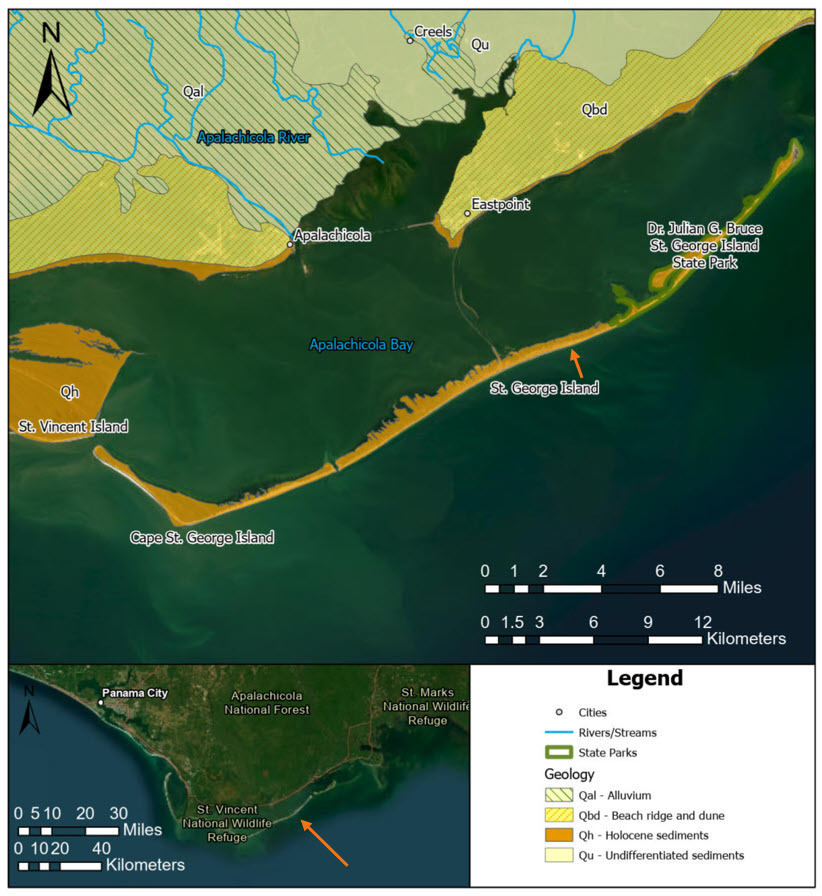 |
Figure 1. Geologic map of St. George Island and surrounding region. Note that sediments mapped on St. George Island were deposited during the Holocene. The inset map shows the location of St. George Island (orange arrow) along the Florida Panhandle. Apalachicola Bay, at the mouth of the Apalachicola River, is protected from the wave energy of the Gulf by St. George Island. Surrounding barrier islands include Dog Island to the east and Cape St. George and St. Vincent Island to the west.
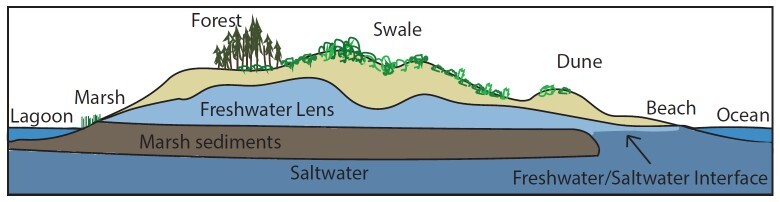
Erosion and deposition of sediments lead to the distinct geomorphology observed on barrier islands (Figure 2). High-energy waves crash on the beach, continually depositing and eroding sediment, forming the shoreface on the gulf-facing side of the island. Dunes form by aeolian processes, when wind erodes, transports and deposits sediment. Dunes form where the wind-blown sediment, such as sand, is deposited and accumulates. These dunes may become anchored by plants like sea oats whose roots hold them in place. Swales are the low areas between the dunes. Sub-parallel beach ridges form over time, recording past beach locations as discussed in FGS article Featured Formation: Quaternary Undifferentiated Sediments and other Undifferentiated Quaternary Units in Florida, Part II. Scientists study these ridges, formed by past wave and wind action, to reconstruct changes in sea level. Washover fans, like the ones created on St. George Island during Hurricane Michael, form when waves wash over the island, carrying sand from the gulf-facing beach and dunes to the back bay, or lagoonal side of the island. The back bay is usually protected from intense wave action, resulting in calmer water and deposition of fine-grained sediment (silt, clay, mud and organics) that is often rich in dark organic material.
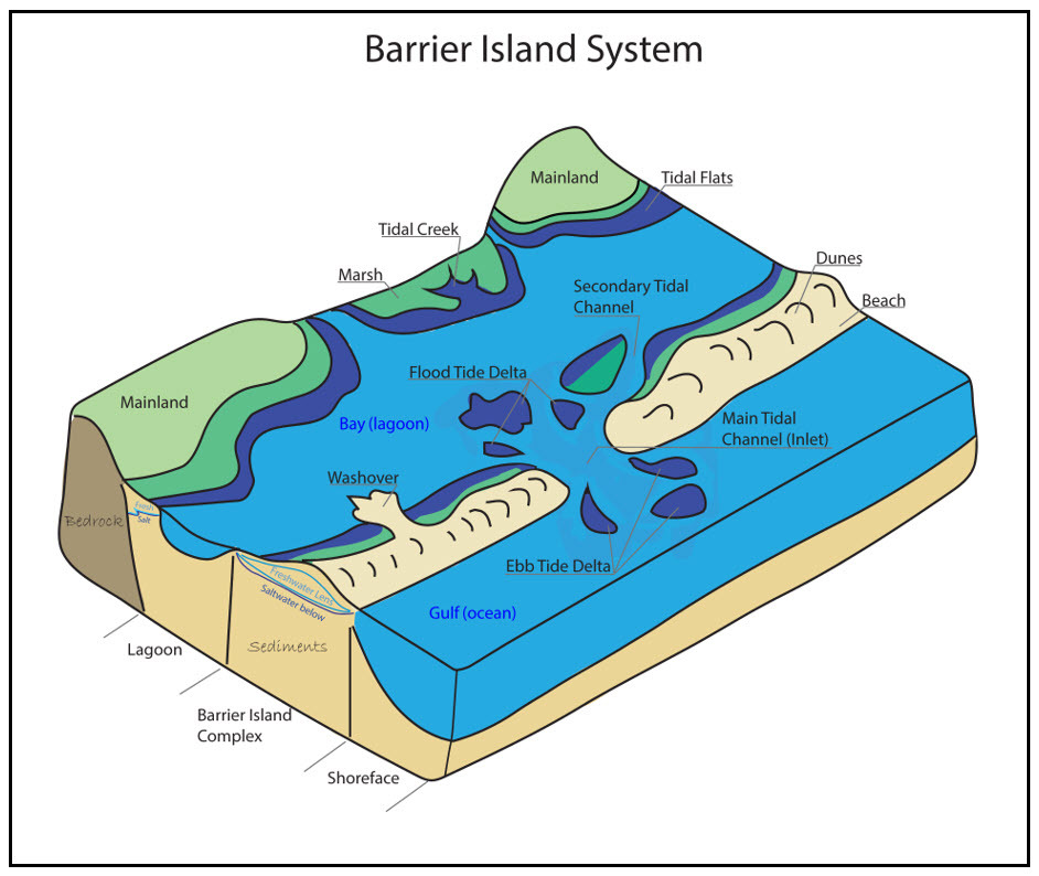 |
Figure 2. Illustration showing the main features associated with barrier island systems (modified from Reinson, 1992).
Barrier island systems are geologically short-lived and have a dynamic depositional regime, with large quantities of sediment being deposited and eroded daily. To form, they must have a nearby sediment supply. For St. George Island and its neighboring islands, this is the Apalachicola River, the largest river by water volume in Florida. The Apalachicola-Chattahoochee-Flint (ACF) River Basin begins northeast of Atlanta, Georgia, carrying water and sediment downslope to the ocean. The quartz sand and clay transported by the Apalachicola River are derived from the southern Appalachian Mountains. As a river reaches the ocean, the velocity of its water slows, causing sediments to settle. Siliciclastic sediments from the southern Appalachians are deposited at the mouth of the Apalachicola River, to then be picked up by gulf currents. Longshore currents are the primary mechanism for bringing sediment deposited at the mouth of the river to the islands. Longshore currents, as the name suggests, move along the shoreline, parallel to the shoreface, depositing and eroding sand from the beach. Over time these currents can reposition whole barrier islands down current.
Barrier island morphology can be mapped in the near subsurface using ground-penetrating radar (GPR), as seen in Figure 3 below. GPR data were collected across St. Vincent Island, just to the west of St. George Island. Data were collected perpendicular to the shoreface and crossing numerous ridges and swales. GPR relies on contrasts in material properties in the subsurface, enabling them to be detected or imaged. Properties such as grain size, water content, induration, mineralogy, permeability and porosity all effect the GPR signal. For example, the boundary between sand and well-indurated (hard, well-consolidated) rock will be a bolder reflector in a GPR radargram than a boundary between unconsolidated dry coarse sand and dry fine sand. The GPR data show layering of sands that comprise different stages, or generations, of beach ridge development in a process known as accretion. Sand layers are sloping toward the sea as the sediments have accumulated over time. Beds can be seen truncated by erosion with a new set of beds stratigraphically above or younger than the eroded set.
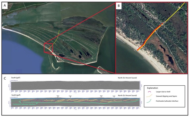 |
Figure 3. One section of a GPR transect on St. Vincent Island, Florida. A. The location of the transect is indicated by the red box and enlarged to show detail, B. The red line in panel B shows the transect location. The yellow line shows Road 4. On the GPR transect profile, C, the left side is the south (gulf) and the right is north (St. Vincent Sound). The X and Y axes are reported in meters. The top GPR image is the processed GPR profile and below is the interpretation of the same profile. The water table is visible within a few feet (1 meter) of the surface and shows up as a distinct “reflector” across the profile (blue line in interpretation). Seaward dipping sand layers are highlighted (tan lines) along with potential buried shells or other clasts (magenta). The freshwater/saltwater interface is also noted by a decrease in GPR signal, called attenuation (light green line). Click here to see a higher-resolution image.
Also visible in the GPR data is the freshwater/saltwater interface. The hydrology of barrier islands is unique. Many have a small freshwater lens that is “floating” above the denser saline groundwater below (Figure 4). In areas where the water table intersects the ground surface, small ponds develop. Though often ephemeral, these ponds can provide a crucial resource for island organisms.
Figure 4. Cross-section through a barrier island showing the freshwater lens above marsh sediments and above saltwater (modified from Riffe et al., 2024).
The geomorphology of St. George Island is comparable to other barrier islands in the Lower Delta Province of the Apalachicola Delta District (Williams et al., 2022). St. Vincent Island, part of the St. Vincent National Wildlife Refuge, Cape St. George Island (Little St. George Island), St. George Island and Dog Island share many features, as their geologic materials and processes are similar. Well-studied beach ridges on neighboring St. Vincent Island were deposited within the last 5,000 years (Forrest, 2007). St. George Island shares a similar depositional regime and timeline of formation (Osterman et al., 2009; Rink and López, 2010). Sea level changes, as documented by Balsillie and Donoghue (2004), strongly determined when and where these islands formed. As the last glacial cycle ended and sea level rose during the early Holocene, shoal conditions were in place for the formation of these barrier islands. For more details and visual summary of the geologic history, explore the USGS Fact Sheet Holocene Evolution of Apalachicola Bay, Florida (Osterman and Twichell, 2011).
Interestingly, the Big Bend region of Florida, just to the east of St. George Island, lacks barrier islands. The rivers in this region provide less sediment than the Apalachicola River. They have more local watersheds and flow over different geologic material. This area is in the Ocala Karst District, and limestone is close to the surface. Sand and clay, prevalent in the Apalachicola Delta District, are thin here. Because of a lack of siliciclastic sediment supply, large barrier islands do not form here.
Dr. Julian G. Bruce St. George Island State Park serves as an example of Holocene geological processes at work along the Gulf Coast. The park is a great place to witness barrier island features in an undisturbed setting and observe the continual movement of sediment within the barrier island system.
References Cited
Balsillie, J.H., and Donoghue, J.F., 2004, High resolution sea-level history for the Gulf of Mexico since the last glacial maximum: Florida Geological Survey Report of Investigation 103, 66 p., https://doi.org/10.35256/RI103.
Forrest, B.E., 2007, Evolution of the Beach Ridge Strandplain on St. Vincent Island [Ph.D. dissertation]: Tallahassee, Florida State University, 269 p., http://purl.flvc.org/fsu/fd/FSU_migr_etd-4416.
Osterman, L.E., and Twichell, D.C., 2011, Holocene Evolution of Apalachicola Bay, Florida: U.S. Geological Survey Fact Sheet 2011-3028, 2 p., https://doi.org/10.3133/fs20113028.
Osterman, L.E., Twichell, D.C., and Poore, R.Z., 2009, Holocene evolution of Apalachicola Bay, Florida: Geo-Marine Letters, v. 29, no. 6, p. 395-404, https://doi.org/10.1007/s00367-009-0159-1.
Reinson, G.E., 1992, Transgressive barrier island and estuarine systems, in Walker, R.G., and James, N.P., eds., Facies models response to sea level change: Geological Association of Canada GeoText 1, p.179-194.
Riffe, E.C., Canfield, M., Sabo, A.B., White, A.E., and Zinnert, J.C., 2024, What are barrier islands and how are they affected by climate change? Frontiers for Young Minds, v. 12, 1347213, https://doi.org/10.3389/frym.2024.1347213.
Rink, W.J., and López, G.L., 2010, OSL-based lateral progradation and aeolian sediment accumulation rates for the Apalachicola Barrier Island Complex, North Gulf of Mexico, Florida: Geomorphology, v. 123, p. 330-342. https://doi.org/10.1016/j.geomorph.2010.08.001.
Williams, C.P., Scott, T.M., and Upchurch, S.B., 2022, Florida Geomorphology Atlas: Florida Geological Survey Special Publication 59, 238 p., https://doi.org/10.35256/SP59.
*Note that the Gulf of Mexico is now called the Gulf of America.
Contact: Casey Albritton, P.G.
Suggested Citation
Albritton, C., 2026, Geology in the Real Florida: Dr. Julian G. Bruce St. George Island State Park: FGS News and Research Winter 2026 edition. https://content.govdelivery.com/accounts/FLDEP/bulletins/4067725#link_8.
Back to top
Between 23 and 3.6 million years ago, a super predator swam the oceans. Otodus megalodon, meaning “big tooth,” is more commonly known as the megalodon shark. Paleontologists estimate that megalodon could reach 60 feet in length, which is about 4 times larger than its modern-day cousin, the great white shark. Based on recent findings, some paleontologists suggest megalodon could have even reached lengths up to 80 feet (Figures 1 and 2).
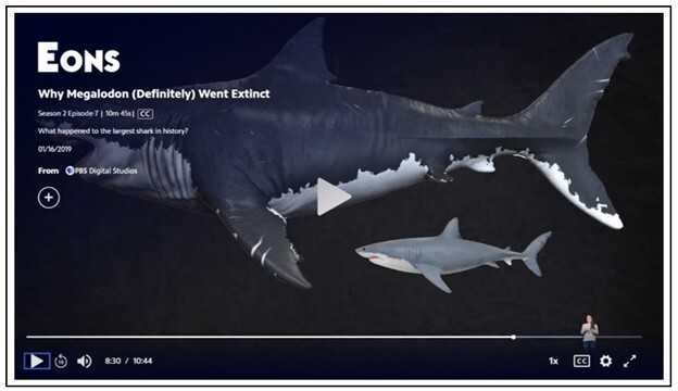
Figure 1. Explore the size, diet and evolutionary history of megalodon in this PBS video, “Why Megalodon (Definitely) Went Extinct.” The above image from the video shows a reconstruction of a megalodon in relation to a great white shark.
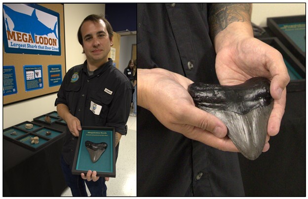
Figure 2. Nick Hall (author) with a model megalodon tooth he 3D printed and painted. The model is to scale and accurately displays the size of the tooth.
Megalodon Fossils
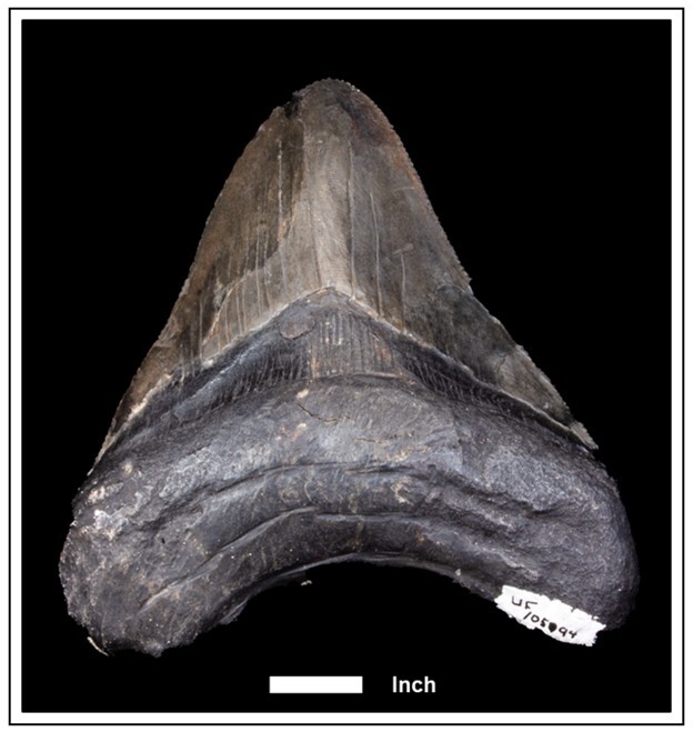
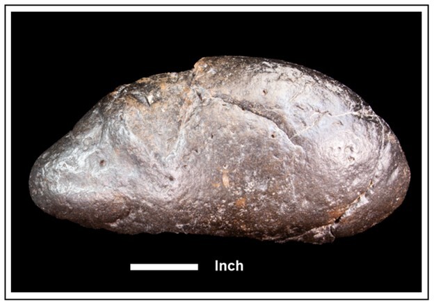
Like modern sharks and even humans, the megalodon’s teeth are made of a mineral called fluorapatite. The teeth have a tough outer layer of enamel and a softer inner layer of dentin. Fluorapatite is a relatively stable mineral, which fossilizes easily. Just like its modern-day cousin, the great white shark, the megalodon was constantly losing and growing new teeth. The growth-to-loss rate of megalodon’s teeth, combined with how readily these teeth fossilize, resulted in an abundance of megalodon teeth in the fossil record. These teeth typically range from 3.5 inches to 7 inches long. The largest tooth discovered to date was 7.48 inches long and was found near Ocucaje, Peru. The Walter Schmidt Museum of Florida Geology at the FGS has a 6.75-inch long megalodon tooth currently on display. This large fossil shark tooth is on loan from the Florida Museum of Natural History (FLMNH; Figure 3).
Figure 3. Megalodon tooth on display at the Walter Schmidt Museum of Florida Geology.
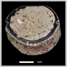
Megalodon vertebral centra have been found as well, reaching a diameter of up to 9 inches. Figure 4 shows a centrum on display at the Walter Schmidt Museum of Florida Geology. Centra are the central parts of the vertebrae that run down the back of vertebrate animals along the spinal cord. These are rare to find, though, because of their composition. Sharks are part of a group of fish known as Chondrichthyes, or cartilaginous fish. Rather than bone, their skeletons are primarily made from cartilage. Cartilage does not fossilize well and for that reason fossilized megalodon vertebral centra are rare finds.
Figure 4. Megalodon vertebral centrum on display at the Walter Schmidt Museum of Florida Geology.
There is another fossil that can be found from the megalodon and it may not be the most obvious: coprolites. What is a coprolite? It is, to put it simply, fossilized feces (Figure 5). In addition to several teeth and a vertebral centrum, the FGS also has a megalodon coprolite on display, on loan from the FLMNH.
Figure 5. Megalodon coprolite on display at the Walter Schmidt Museum of Florida Geology.
Discovery of Megalodon
Megalodon teeth were excavated and used as serrated blades, knives and jewelry by pre-Columbian cultures in the Americas. When megalodon teeth were first discovered by the scientific community, it was thought that they were not teeth at all, but instead fossilized tongues. The earliest scientific publication about the megalodon was written in 1616 by Italian naturalist Fabio Colonna. He illustrated the tooth of a Maltese megalodon alongside the tooth of a great white shark and noted the similarities between the two. Few people thought that his interpretation of the fossil as a tooth was accurate because these teeth were found so far inland. In 1667, Nicolas Steno described his dissection of the head of a great white shark and related the teeth of the great white shark to those found as fossils. It was not until 1843 that the megalodon was officially described by Swiss naturalist Louis Agassiz, who gave it the Latin name Carcharodon megalodon. This description of the huge predator sparked the interest of the scientific community and the public. To this day there are new discoveries and discussions about the megalodon, now referred to as Otodus megalodon. Currently, scientists debate what the giant shark looked like. Was it similar to a larger modern-day great white? Paleontologists now suggest that it may have looked more like a mako shark or even a whale shark.
Distribution, Feeding and Extinction
Megalodon fossils have a broad distribution. Its geographic range was global, with fossil remains found in Europe, Africa, the Americas and Australia. This implies that the megalodon was highly adaptable. Paleontologists also discovered that megalodon was able to live in a wide range of marine environments including shallow coastal waters, swampy coastal lagoons and offshore deep-water environments. It is thought that as it grew the megalodon may have moved from coastal to oceanic waters due to its size and the kind of prey it hunted throughout its lifecycle. This may be the reason why megalodon teeth can be found all over the world.
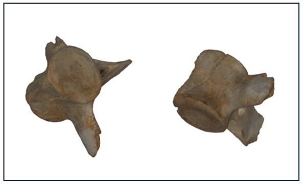
Sharks are typically known for being opportunistic feeders. They will take advantage of whatever food source is around rather than specializing on a narrow diet. Megalodon was an apex predator, at the top of the food chain. It had no natural predators, except for one: other megalodons. This massive shark fed on a broad spectrum of animals including whales, dolphins (Figure 6), seals, sea turtles, fish and other sharks. There is fossil evidence of a whale vertebra bitten in half by a megalodon. The whale remains contain linear cut marks that match megalodon teeth, and megalodon teeth were found near the remains.
Figure 6. Two views of a dolphin vertebra with tooth marks indicating predation, possibly from a megalodon. The vertebra is on display at the Walter Schmidt Museum of Florida Geology.
Modern sharks typically use complex hunting strategies to take down large prey animals. The fossils of a Miocene baleen whale from about 15 million years ago contain bite marks and compression fractures suggesting that they were rammed into with a great amount of force from below before they were eaten. During the Pliocene, beginning around 5 million years ago, larger cetaceans (whales) appeared due to environmental changes and the onset of the ice ages. These environmental changes caused food sources to be concentrated into dense, seasonal patches. This favored larger whales that could travel longer distances and were able to consume more prey in a single lunge, thus providing an evolutionary advantage that led to their massive size. Megalodon kept pace, continuing to evolve its hunting strategies in competition with these whales.
Megalodon’s extinction may have been caused by a few different factors, including changes in sea level and the loss of its prey. During the Pliocene, the climate cooled and sea level fluctuated. This may have negatively affected the nursery areas or coastal habitats where food was available. Extinction rates of marine megafauna (the largest marine animals) during the Pliocene were particularly high. With the drop in population of the marine megafauna that megalodon is thought to have fed on, along with environmental changes related to climate and sea level changes, this apex predator may have been too large to sustain itself on a reduced diet, leading to its inevitable extinction.
Florida Fossils
Florida’s geologic history during the Cenozoic Era proved ideal for the preservation of fossils, especially shark teeth. Venice Beach, Florida, is known as the shark tooth capital of the world. In addition to megalodon teeth, visitors can find fossil teeth from great white, reef, bull and lemon sharks.
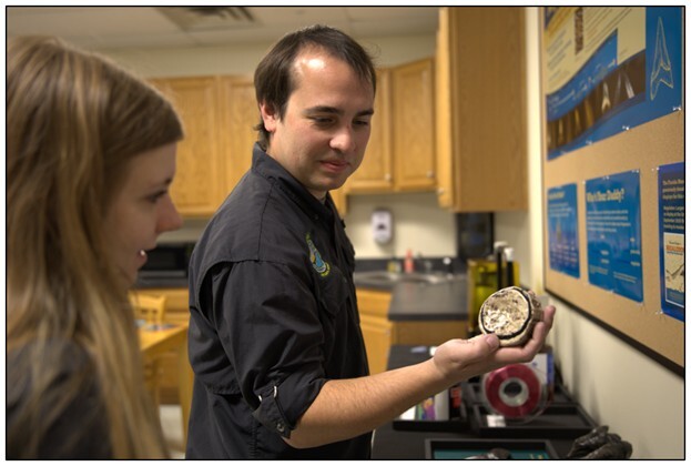
View 3D images of megalodon teeth found in Florida, a megalodon centra, a megalodon coprolite and the dolphin vertebra in Figure 6 in the Florida Geological Survey collection. These images were produced in collaboration with Florida State University (FSU) using Artec 3D scanners. These models can be downloaded and used with 3D printing software to print physical copies of these megalodon fossils (Figure 7).
Figure 7. Nick Hall (author) with a printed megalodon vertebral centrum. He downloaded the digital model from the Florida Geological Survey collection, 3D printed and painted it. The model is to scale and accurately represents the size of the centrum.
Using new research techniques like 3D scanning of fossils, bite force calculations, modeling body shapes and movements, analysis of growth bands on centra and geochemical analyses, scientists continue to discover new things about the life of megalodon.
Additional Resources
Brown, R.C., 2008, Florida's Fossils: Guide to Location, Identification, and Enjoyment: Sarasota, Florida, Pineapple Press, 216 p.
Cooper, J.A. et al., 2022, The extinct shark Otodus megalodon was a transoceanic superpredator: inferences from 3D modeling: Science Advances, v. 8, eabm9424, https://doi.org/10.1126/sciadv.abm9424.
Pimiento, C., and Balk, M.A., 2015, Body-size trends of the extinct giant shark Carcharocles megalodon: a deep-time perspective on marine apex predators: Paleobiology, v. 41, p. 479-490, https://doi.org/10.1017/pab.2015.16.
Pimiento, C., and Clements, C.F., 2014, When did Carcharocles megalodon become extinct? A new analysis of the fossil record: PLoS ONE, v. 9, e111086, https://doi.org/10.1371/journal.pone.0111086.
Pimiento, C., Ehret, D.J., MacFadden, B.J., and Hubbell, G., 2010, Ancient nursery area for the extinct giant shark megalodon from the Miocene of Panama: PLoS ONE, v. 5, e10552, https://doi.org/10.1371/journal.pone.0010552.
Renz, O.M., 1999, Fossiling in Florida: A Guide for Diggers and Divers: Gainesville, Florida, University Press of Florida, 216 p.
Renz, O.M., 2002, Megalodon: Hunting the Hunter: PaleoPress.net, 170 p.
Contact: Harley Means, P.G.
Suggested Citation:
Hall, N.P., 2026, The Megalodon: FGS News and Research Winter 2026 edition. https://content.govdelivery.com/accounts/FLDEP/bulletins/4067725#link_6.
Back to top
|