|
Greetings, and welcome to the
Spring 2017 edition of FGS News and Research. In this issue, we're taking a look at Light Detection
and Ranging (LiDAR) and its important uses statewide. In addition, we're highlighting our library of geologic information
located at FGS headquarters in Tallahassee, along with our
digital List of
Publications and web
catalog. I also invite you to learn more about lithostratigraphy and how geologists define formations in this newsletter’s
GEOFACT.
There are many reasons I continue
to be proud to lead such an effective organization. During the past few months,
hundreds of Florida citizens have benefited from our robust outreach program
through lectures, field trips and our mobile laboratory of rocks and minerals.
Our dedicated staff take part in these events, along with managing multiple
projects to meet the DEP and FGS’s goals and mission. Our annual FGS Awards
ceremony held at Maclay Gardens recently allowed me to express my gratitude to
a few of these individuals.
Sincerely,
 Jonathan D. Arthur, Ph.D., P.G.
Director and State Geologist
Florida Geological Survey
Florida Department of Environmental Protection


Saying the word
“lithostratigraphy” may be cumbersome, but it describes a fascinating study of
geologic materials. Stratigraphy is the branch of geology that deals with the
study of strata, or the layers of sedimentary rock that have accumulated over geologic
time. There are different focus areas of
stratigraphy; for example, the study of fossils contained within the layers is
called biostratigraphy (“bio” is Greek for “life,” and fossils are proof of
life). The study of ages of these layers is called chronostratigraphy (“chrono
is Greek for “time”), and the focus on the rock and sediment composition is
called lithostratigraphy (“lithos” is Greek for “rock”).
Formations
are the basic rock units that are used in stratigraphy and are defined by the geologic materials,
or lithology, that comprise a rock layer. Geologists follow rules
when defining a formation. These rules are laid out in
the North
American Stratigraphic Code, which was developed to ensure that geologists
are consistent in how they define stratigraphic units.
A formation must be mappable and easily
recognized over a broad area. Additionally, to properly define a lithostratigraphic unit, a geologist must define and describe the lithology of the unit and show that it is different enough from adjacent rock layers that it can be recognized by other geologists. If the formation is exposed at the surface, a "type section" is designated for reference, while if a formation occurs below the ground, a type core taken using a drill rig may be used instead.
An example of a lithostratigraphic unit is the Anastasia Formation on Florida's East Coast. This formation is primarily
comprised of quartz sand and seashells that have been cemented together to form
coquina. The lithology is recognizable,
and occurs over a large enough area that it can be depicted on maps at various
scales. The Anastasia Formation is a
formal lithostratigraphic unit because its lithologic character has been
described and the extent of where this formation occurs, both laterally and
vertically, has been mapped and defined.
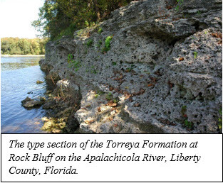
Let’s look at an example of lithostratigraphy in action. The Miocene
Torreya Formation was first described and named by geologists Joe Banks and
Muriel Hunter in 1973. The Torreya Formation’s lithology is a clayey, quartz
sandy, phosphatic carbonate that contains Early Miocene marine fossils. Almost 100 feet of the formation is exposed along the east bank of the
Apalachicola River at Rock Bluff in Liberty County. This is the designated type
section for this formation. The Torreya
Formation can be traced from its type
section across Northeast Florida
and into Madison County.
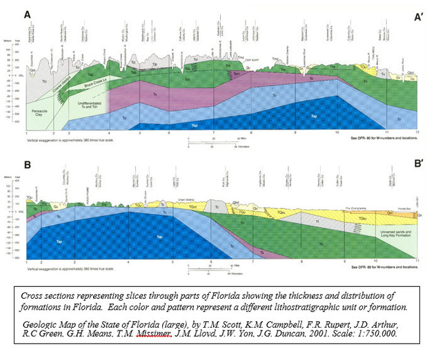
Being able to distinguish
and map lithostratigraphic units gives geologists the ability to see how geology changes over an area and over time. It also allows geologists to construct geologic
maps and two-dimensional slices of the earth’s crust, called cross sections (pictured
below). Important resources, like
minerals and groundwater, are contained within geologic formations. Knowing how
formations are distributed across an area in three dimensions, including how
they are related to adjacent rock layers and what they are comprised of, allows
geologists to more accurately identify mineral or groundwater resources.
If you are still thinking about Greek words and water comes to mind, it should be no surprise that the study of the relationship between groundwater and subsurface layers is called hydrostratigraphy, which will be explored in a later issue of FGS News and Research.
|
Contact: Harley Means, P.G. Administrator
Back to top
The mission
of the FGS is to collect, interpret and provide objective, quality information
about Florida to its customers. One way FGS accomplishes its mission is through
various education and outreach events. The mission has continued to drive FGS
professionals to engage in as many outreach efforts as possible since the new
year. During 2017, FGS staff have taken
part in a variety of events around the state.
January got
off to an exciting start when Harley Means, P.G. Administrator, was interviewed
for WFSU’s Local Routes program. The film
segment, “A Geologist’s View of the Apalachicola River,” aired on
February 9. This was the
second of two educational videos he took part in for Local Routes, the first of which discussed fossils and archaeology. In addition to Local Routes, Harley worked with WFSU on a video about the Old Vero
Man archaeological site for an upcoming Florida public television production.
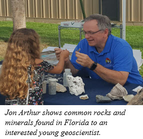
The FGS was thrilled to
be invited to Woodville K-8’s “STEAM Night” (celebrating Science, Technology,
Engineering, Arts, and Mathematics) at the beginning of February. Sarah Erb,
Sarah Lovins, and Harley Means staffed the “FGS Rocks and Minerals Mobile Lab”
booth. Children, educators, and even
some interested parents asked questions related to fossil specimens, types of
rocks, and watched demonstrations on how sediment settles and examples of limestone
porosity. Children expressed awe at the size of the dugong rib fossil on
display, discovered the beauty of a sea biscuit and the sharpness of shark
teeth, while others enjoyed the hands-on aspect of fossil examination. A couple
of students expressed an interest in becoming geologists and adults were just
as inquisitive. It was clear the night was a success when all three FGS staff
stayed busy answering questions from more than 50 booth visitors.
On February 28, 18
students and four adults from the Cornerstone Learning Community came to the
FGS Museum to hear professional geologist Christopher Williams discuss rocks
and minerals and tour various specimens at the museum, such as a dugong
skeleton and an extinct mako shark jaw. A
similar opportunity was also provided during April to local Cub Scouts
(Webelos) and their parents to help the scouts earn geology badges.
February also included
talks about springs and sinkholes at the FSU Marine Lab and the Waterworks
Science Salon. Director and State Geologist Jon Arthur also provided a lecture
to 88 FSU students about the FGS, Florida’s hydrogeology and the geoscience profession.
FGS staff, including Laboratory
Technician Jesse Hurd led a field trip to Alum Bluff along the
Apalachicola River for a University of Florida Paleontology class. Another
field trip to Alum Bluff was conducted for students of University of South
Florida to view the area’s unique geological features.
The FGS shows no sign of
slowing down during 2017 with its outreach efforts. Thanks to the hard work of
Scott Barrett Dyer, Environmental Specialist, and Laboratory Technician Jesse
Hurd, over 200 students at Roberts Elementary School learned about water
transport with a new physical model developed at FGS, exhibiting how surface
water and groundwater is transported in North Florida. Members of the Free
Masons of the Jackson Lodge learned about sinkholes from FGS’s Clint Kromhout.
These outreach events are
just the beginning of what promises to be a productive year for public
geoscience education. Most recently, FGS staff provided a “hands-on
geology” booth for more than 200 people on Earth Day at Cascades Park in Tallahassee
as part of the annual Healthy Communities Festival. We enjoyed one-on-one or one-on-many time
with hundreds of visitors, and plans are already being made for Earth Science
Week this Fall. The benefits of these
outreach efforts have a positive and incalculable effect on our environment!
Contact:
Sarah Erb, OMC Manager
Back to top
|
Top performers of 2016 were recognized at the recent FGS
Awards Ceremony held at Maclay Gardens State Park in Tallahassee.
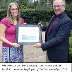
Sarah Erb, OMC Manager, was honored as the Employee of the
Year for 2016. Sarah joined the FGS in 2011 as a part-time Secretary
Specialist and part-time OPS working for the STATEMAP program. The following
year, she became a full-time FTE as the Administrative Assistant to the FGS
Director. In December of 2015, she was promoted as the section head for the
FGS’ Administration Section, and was able to serve in this role for the first
full year during 2016. Sarah is dedicated, hard-working and gets along with
everyone.
Traci Billingsley, Government Operations Consultant III,
was honored with the Sustained Exemplary Performance Award for her continued
excellence in service as FGS budget and grant coordinator, building and
contract management, property custodian and multiple other duties. Her
practical efficiency, insight, reliability and experience make her an
invaluable asset to the FGS. Her work
affects nearly every person at FGS, and her strong work ethic and willingness
to go above and beyond for over 10 years at FGS make her deserving of
this recognition.
An Individual Extra Effort Award was presented to Mary
Esposito, Administrative Assistant III, due to her helpful, productive and
cheerful willingness to do whatever it takes to help the FGS, even if it is
not one of her core duties. Mary is always busy helping customers and FGS
employees, serves as the HR and Training liaison, assists the FGS Director,
and steps in whenever help is needed. When she joined the FGS in
2015, she instantly became an irreplaceable member of the FGS family.
Brianne Apolinar, Environmental Specialist III, was also
presented with an award for Individual Extra Effort. Brianne was promoted
from OPS to a grant-funded FTE during 2016, and stepped in during a critical
time for the STATEMAP program. Her expertise, willingness to train others
and hard work were crucial to help complete this important project. Brianne
is a pleasure to work with and her coworkers admire her dedication.
A Team Extra Effort Award was
presented to the Mosaic Geologist Monitoring Team, which was composed of Jon
Arthur, Harley Means, David Paul, Alan Baker, Cindy Fischler, Dan Phelps, Tom
Greenhalgh and Jim Cichon. The team
spent more than 600 hours monitoring multiple drill crews at Mosaic’s New
Wales Facility to provide strategic support to DEP to further ensure public
health and safeguard natural resources. The team volunteered blocks of their time during the final weeks of
December, fielded phones calls, met with public officials and provided
critical updates on drilling progress in a tireless effort to meet the goals
of the DEP and the FGS.
Finally, the FGS Interns that put in many hours during
2016 were recognized. They include Thomas Biamonte, Elena Brooks, Kyle
Compare, Parisa Haghgou, Alexander Lamarche, Sarah Lindeman, Kendrick Nelson
and Jared Raff.
Contact: Mary Esposito, Administrative Assistant III
|
FGS has an incredible
library of geologic information available to Florida’s citizens, but did you
know that the Survey also has a dedicated Librarian Specialist, Doug Calman,
that can help you find what you are looking for? Throughout the day, he answers
reference queries which come in by phone, fax, email or via forms on the FGS
website. He often refers customers to the appropriate staff who specialize in sinkhole questions.
Need to create PDFs of
FGS library materials for research purposes? Some FGS library materials are not
under copyright restrictions but, if they are, Fair Use provisions of the U.S.
copyright law often allow making single copies of certain documents. For ease
of use, the librarian can use a map scanner and a large format plotter for
scanning or making plots of oversize materials.
Of course, if you are not
sure what materials you need, the librarian can run a geological
literature search for you using the GeoRef database, which is administered by
the American Geosciences Institute. Additional databases can be searched, such
as the Cambridge Scientific Abstracts or Google Scholar, which also show
articles cited by a relevant reference.
Once a few good
references on a specific topic are compiled, this dedicated librarian can run a cited author
search on the Web of Science database, an often-overlooked method of locating
relevant research materials.
The
State Library provides state employees with Inter-Library Loan (ILL) forms to
assist in obtaining research materials not owned by the FGS Library. Likewise, ILL
forms come to the FGS Library daily to share the FGS collection
with other libraries across the country.
Not sure where to start?
The FGS Library is open at the FGS headquarters in Tallahassee from 8 a.m. until 5 p.m.
Monday-Friday. FGS publications can be recommended
to you that may be best for answering your research needs, and Doug Calman will
assist with obtaining the full text.
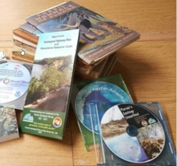
FGS publications are all
online as PDFs for free downloading, and publications which are still in print
may be purchased in paper from the library. See our List
of Publications for
available publications with prices for printed copies. FGS helps users navigate the website and use the FGS Library’s Web Catalog.
Of course, reference
materials are just the start! Are you an educator? If so, the FGS librarian
will mail out free posters to K-12 teachers.
Please contact Doug
Calman to make use of the vast information and services available at FGS.
Contact: Doug Calman, Librarian
Specialist
|
Light Detection and Ranging (LiDAR), or 3D scanning of the Earth’s surface, is a method in which pulsed laser light is used to measure elevations. This important data is used by geologists, engineers, archaeologists, farmers and many other professions. The FGS has used LiDAR for various projects that help to increase understanding of Florida’s geology.
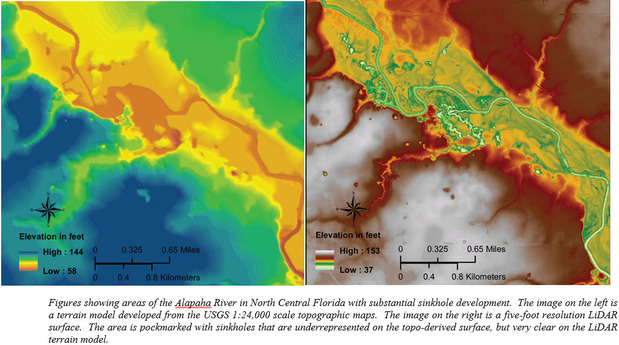
One of FGS' many uses of LiDAR over the past year has been documenting sinkholes in areas across Florida. Field geologists used existing and publicly available LiDAR data as a base layer to identify possible sinkholes prior to beginning field work and the data proved to be very useful in helping direct field crews to potential sinkholes. The data also served as a navigation aid in areas where the terrain made it difficult to access possible sinkhole features, and it was useful for locating sinkholes where the visibility was obscured by vegetation. In addition to locating potential sinkholes and areas prone to sinkhole activity, field geologists could determine slope, depth and diameter of the preexisting features using the LiDAR-derived terrain models and avoid potentially dangerous situations while working in hazardous landscapes.
The STATEMAP program, a cooperatively-funded surficial geologic mapping initiative within the FGS Geological Investigations Section, also uses LiDAR to improve surficial geologic mapping and to search for geologic contacts within a study area. Prior to beginning field work, STATEMAP staff locate, gather and stitch together sections of LiDAR data to create a topographic base map. It can be difficult to manage many of the data sets they accumulate since some are of different resolutions and quality levels, and in many instances, a portion of the study area does not have any data. STATEMAP geologists also use LiDAR prior to scheduling field work to optimize their time in the field. They use the data to map potential geological contacts and geomorphic features by noting consistent and apparent elevation changes.
LiDAR also has important implications for learning more about springs. The FGS’ Applied Geoscience Services (AGS) Section has been using terrestrial LiDAR near the Florida Big Bend coastline to locate and document several small springs. In this low-lying area, staff geologists use the LiDAR-derived terrain models to locate small streams that originate as springs. The models help the geologists navigate the thick brush and swamps and avoid marshy areas. In addition, the AGS uses LiDAR to organize and plan dye-trace studies for select springs and swallets. The LiDAR is used to identify sample points during attempts to trace the flow of surface water as it descends underground through swallets and eventually emerges at a spring vent further down stream.
LiDAR data currently used by the FGS was acquired at different places, over many years and at various resolutions. A joint goal of state and federal partners across the nation is to acquire consistent, statewide LiDAR coverage. An assessment is currently being conducted to determine whether uniform and simultaneous LiDAR data collection would facilitate a variety of applications across government agencies and spur innovations not possible today.
Contact: Alan Baker, P.G. Administrator
Back to top
|