|
Happy New Year, and welcome to the Winter edition of FGS News and Research!
I can think of no better way to start 2018 than to discover more about the fascinating geology just beneath our feet. With that, I invite you to learn about hydrostratigraphy in this issue’s GEOFACT, and explore one of the most widespread geologic units found along the Gulf Coastal Plain: the Citronelle Formation. In addition, this issue brings you closer to a vast world of geoscience information and data.
We look forward to another productive year of service and collaboration. For example, we will be working with Florida Parks Service to develop on-line resources highlighting geologic features within parks across the state. Under the stewardship of the Florida Park Service, 175 state parks attract millions of visitors each year and the FGS looks forward to broadening park visitor engagement through increased exposure to geology.
This Winter 2018 issue also illuminates the numerous methods that DEP and FGS make environmental information discoverable and accessible. Read below to learn more about on-site or online access to interactive maps, reports and publications, geologic collections, and other Florida geoscience data.
Engaging in learning is my lifelong passion, and it is a zeal I share with the FGS team. I take great pride in the great things we are accomplishing, whether it be through new publications, geoscience and strategic operational projects, or through the many achievements of our staff. In closing, I extend a heartfelt thank you for your recent overwhelming support of our data preservation efforts.
Sincerely,

Jonathan D. Arthur, Ph.D., P.G.
Director and State Geologist
Florida Geological Survey
Florida Department of Environmental Protection


In the Spring 2017 FGS News and Research edition, we highlighted the importance of lithostratigraphy, or the stratigraphic focus on rock and sediment composition. We broke down this cumbersome word into its main components: “lithos” being Greek for rock, and “stratigraphy” as the branch of geology that deals with the study of strata, or the layers of sedimentary rock that have accumulated over geologic time. With this knowledge, we are equipped to explore another focus area of stratigraphy: hydrostratigraphy. “Hydro” is Greek for “water” and therefore, hydrostratigraphy is the study of the flow of groundwater through rock and sediment layers. Geologists use this field of study to define and correlate rock and sediment layers as they relate in their ability to yield water.
In the United States, the classification, naming, and mapping of stratigraphic units are defined according to the rules governed by an entity known as the North American Commission on Stratigraphic Nomenclature (NACSN). Unfortunately, the specific focus of area of stratigraphy known as hydrostratigraphy does not have formal nomenclature. While technical terminology to define the collection of rock and sediment which contain similar water-yielding properties is certainly used by geoscientists studying hydrostratigraphy, stratigraphic units defined by the NACSN cannot be used for hydrostratigraphic units because water-yielding permeability properties of rock and sediment can cross lithostratigraphic unit boundaries. To visualize this, let’s examine the chart below, which illustrates correlations between hydrostratigraphic and lithostratigraphic units (formations) by age and region in Florida. The colors correspond to the hydrostratigraphic units. As you can see, the singular hydrostratigraphic unit may contain multiple geologic formations (see vertical columns for three areas of Florida). Additionally, water within a hydrostratigraphic unit is often younger than the lithostratigraphic unit in which the groundwater resides or flows.
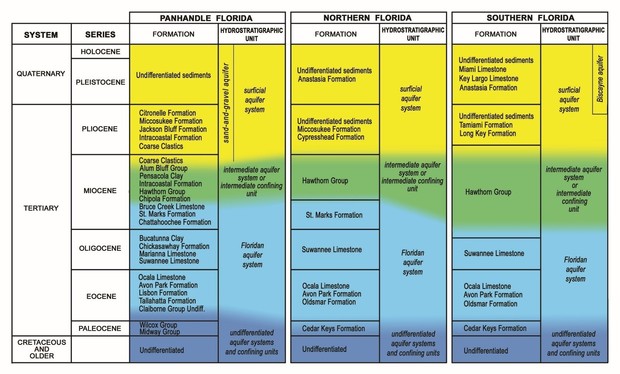
As with named lithostratigraphic units, such as formations, hydrostratigraphic units must be of sufficient size and thickness to be mappable at defined scales. The criteria by which hydrostratigraphic units are defined, classified, and mapped are inconsistent throughout the United States, although some consistency does exist within Florida. Some of these examples are as follows:
Generalized definitions:
- Aquifer - Permeable rock and sediment that yields water.
- Aquifer system – A regional and sub-regional mixed body of permeable and less permeable rocks and sediments from which the more permeable layers yield water.
- Zone - Water-yielding unit smaller than an aquifer.
- Confining unit – A regionally mappable package of rock and sediment that generally does not yield water and has low to no permeability.
- Confining bed (or layer) - Small layer of rock or sediment that does not yield water and has low to no permeability, and is only mappable at a local scale.
Florida has taken initiative to develop statewide definitions, classifications, and mapping of its water-bearing hydrostratigraphic units. In 1986, the Florida Geological Survey published the “Hydrogeological Units of Florida,” FGS Special Publication 28. This publication is the result of discussion and agreement between members of an Ad Hoc Committee on Florida Hydrostratigraphic Unit Definition that was convened by the Southeastern Geological Society in 1982. The committee was comprised of geologists, hydrologists and hydrogeologists employed by state agencies, federal agencies, academia, and the private sector. The defined units (see above) have since become ingrained in Florida geoscience literature on which the mapping, management and protection of groundwater resources is based. Improved understanding of Florida’s complex hydrogeologic setting is shaping future refinements to this nomenclature.
Contact: Clint Kromhout, P.G. Administrator
Back to top
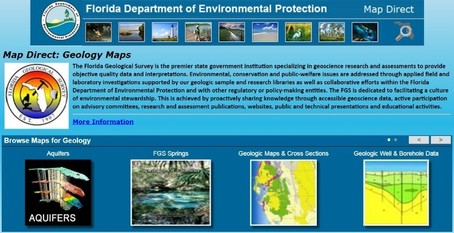
Did you know that the FGS Geologic Information and Data Management (GIDM) section provides public access to vast amounts of geoscience data? Data series and project deliverables can be obtained either through the FGS Library as physical documents such as maps, reports, publications, and posters, or through the Internet using many of the Department’s available resources. Hard copy documents and posters, etc. are available through contacting the FGS Librarian. Alternatively, one can access FGS through our designed web page. Let’s further explore some of the avenues you can use to retrieve information.
Over the last few months, we have improved our website to simplify the path between you and the geologic data you seek. Several new pages are specifically designed for locating information related to the State’s geologic collections. For example, to obtain a well summary, you can search by county or borehole number (the FGS W-number). To access our scanned geophysical logs, follow this link. Additional types of available data include inventory of physical collections and their availability, lithologic descriptions, and drillers logs.
The Department’s Map Direct resource (see other links below) provides geospatial access to geology or boreholes and you can also customize, share, and print maps all within the Map Direct Galleries. Tools are available to add layers, annotate text, and query tables by adding available layers into their customized maps.
Efforts to improve data accessibility cannot be accomplished without help from other program areas. For example, a legacy dataset was recently compiled with significant help from the DEP Northeast District office. Scans were made of all FGS “Greenbooks” (drillers logs, geologic descriptions, water policy and historic correspondence concerning samples or construction of individual wells) and made available online. Before this effort, this resource existed only as sets of paper documents in green three ring binders, sorted by W-number and grouped by county. These are a valuable source when attempting to quantify the locational information about a borehole/well.
The FGS is also sharing various online maps through the updated website, such as interactive maps of aquifer potentiometric mapping. Other online maps in the form of ESRI’s “Story Maps” (themed web applications maps combined with narrative text). Some of the themed maps are of Geologic Mapping in Florida, another on selected Geologic Sites in Florida, and one dedicated to Florida’s Geologic History. Additionally, all of DEP’s sharable data is available through the Geospatial Open Data Portal (see links below). The FGS has 34 datasets associated with Florida’s geological environment located within the portal, as well as data associated with aquifer vulnerability, potentiometric surface maps, subsidence incident reports, springs and swallets, and oil, gas, and mining.
It is paramount that accessible data be as accurate as possible. While this data is currently available, the FGS provides quality data. Staff continually work to correct and attribute all data and are working hard to improve data availability. For example, the GIDM section has reviewed and accredited over 60 percent of FGS borehole records to verify that paper records have been accurately inserted into our database along with a location accuracy statement for each record.
The FGS is also embarking on a complete inventory and mapping of its sample repository and, with help and guidance from the Department’s Office of Technology and Information Systems, has contracted with a company to update and modernize the current borehole database. The new ORACLE-based system will be called GEODES (Geologic Data Enterprise System) and is approximately one year from completion. Between GEODES and continued development of StoryMaps and DEP’s Map Direct resources, user-friendly and robust access to our data will improve!
Contact: Alan Baker, P.G. Administrator
Links to Explore:
· FGS Publications webpage
· FGS Publication Query
· FGS Geologic Information and Data Portal
· FGS Borehole Summary Query
· FGS Geophysical Log Query
· DEP List of Map Direct “Geology Maps”
· DEP Business Portal/Geology
· FGS Greenbook Index
· Other FGS online map products
· DEP Geospatial Open Data Portal
· County Geologic Maps
· Oil and Gas Geophysical Logs (sorted by Oil and Gas Permit Number)
Back to top
|
See most recent previous issues to learn about other geologic formations.
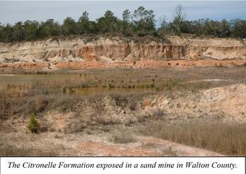
The Citronelle Formation was formally named by George C. Matson in 1916 after a small town in southeast Alabama near the type section (a geologic outcrop from which a formation is defined) of the formation. One of the most widespread geologic units found along the Gulf Coastal Plain, the Citronelle Formation extends from east Texas across much of the Florida Panhandle. The unit consists primarily of unconsolidated quartz sand and gravel with varying amounts of clay and trace amounts of heavy minerals and mica. In Florida, the Citronelle Formation occurs from Escambia County east into central Gadsden County where it grades laterally into the Miccosukee Formation. Exposed along many roads, creeks, and river cut-banks, the Citronelle Formation caps the tops of hills including Florida’s highest point located in northern Walton County (345 feet above sea level).
If you were to pick up sand and gravel from the ground in north Florida might you think it came from the southern Appalachian Mountains? You would be right if you did! Geologists have investigated the origin and age of the Citronelle Formation and its sands and gravels have been traced to igneous and metamorphic rocks of the Appalachians that were broken down over millions of years. As these rocks eroded, the quartz sand and gravel were transported by streams and rivers to the Coastal Plain and ultimately deposited in formations like the Citronelle Formation. This unit was most likely deposited as stream and river deposits during the late Pliocene or early Pleistocene epoch. A portion of the formation was deposited in a near-shore marine environment in river deltas that formed at the mouth of ancient rivers. Evidence for this can be found in parts of Santa Rosa and Walton counties where marine fossils have been found in the Citronelle Formation.
The origin of the Citronelle Formation is certainly better understood than its age. Unfortunately, the Citronelle Formation is largely absent of age-diagnostic fossil material, which makes it difficult to identify exactly when the formation was deposited. Where the Citronelle Formation overlies formations that do contain fossils of a known age, the age of this unit can be constrained by stratigraphic position. For example, at Alum Bluff in Liberty County, the Citronelle Formation overlies the late Pliocene Jackson Bluff Formation, indicating that it cannot be any older than late Pliocene.
In West Florida, the Citronelle Formation comprises part of the surficial aquifer system and is an important source for groundwater. Zones of high porosity and permeability exist in some parts of the Citronelle Formation that are clay-poor and dominated by unconsolidated sand and gravel. Where these zones occur, groundwater can be extracted for human use.
|
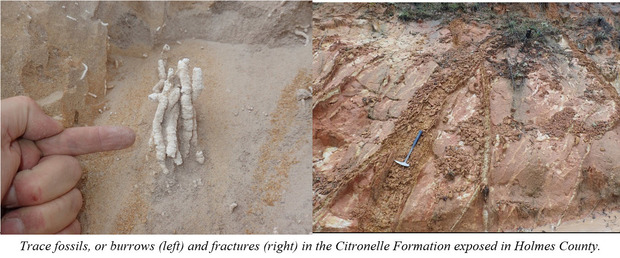 |
Sand and gravel are important mineral commodities used in construction and other industries in Florida. The Citronelle Formation is a source for these commodities, making borrow pits and sand and gravel mines common in areas where the formation occurs. Mining provides good opportunities for geologists to observe cross-sections through the unit. In some mines, it is common to see sedimentary structures like cross-bedding, fractures, and trace fossils that reflect the depositional history of the Citronelle Formation. There are also many natural exposures of the Citronelle Formation where the sediment and structures that comprise this geologic unit can be observed.
Contact: Harley Means, P.G. Administrator
Back to top
The Florida Geological Survey (FGS) is proud to announce three featured publications from the 2017 calendar year. Links to these publications can be found at the links provided below:
FGS Biennial Report 29, 2015-2016, by S.A. Erb, 2017, 26 p.
Potentiometric Surface of the Upper Floridan Aquifer September 2012, by James R. Cichon, 2017. Comes as one rolled color map sheet, 36.07 x 38.33 inches, scale 1:900,000 or online.
Report of Investigation 121: “The Bathymetry, Top of Rock, and Thickness of Unconsolidated Sediments Offshore of the Northeast and Central East Coast of Florida” (2017)
Of course, publications were just a small portion of accomplishments at the FGS during 2017. Successes with both geoscientific projects as well as data and operational improvements were possible due to FGS’ hard-working staff and invested stakeholders. Additionally, the end of the year brought many wonderful achievements among individual staff members.
FGS geologists Mary Beth Lupo, Benjamin Davis, and Keith Munsey passed the Geologist-in-Training component of the Florida Professional Geology licensing program. Three FGS GIS professionals received top recognition at the annual Seven Hills Regional User Group (SHRUG) GIS Workshop:
- Katherine White and Garrett Evans received a first-place award for their poster on Custom Bathymetric Elevation Models for the Tampa Bay Region. The poster focuses on the creation of the custom bathymetric elevation model used in the 2017 St. Petersburg STATEMAP Project.
- Levi Hannon received a third-place award for his poster on Delineating Historical Flow in Florida Panhandle River Basins. A relative elevation model (REM) was generated for each river to show the historical drainage and flow patterns of the major rivers in the Florida panhandle.
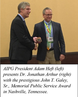
Lastly, Director and State Geologist Dr. Jonathan Arthur was “humbled and honored” when he was recognized by the American Institute of Professional Geologists (AIPG) with the national John T. Galey, Sr., Memorial Public Service Award. Details about the award and its recipient can be found on pages 18-19 of AIPG’s Professional Geologist, Volume 54, No. 4, July-Aug-Sept 2017. FGS staff are motivated by personal passion, FGS leadership and our shared vision to provide timely, high-quality, and objective research and assessments to the public in response to environmental, conservation, and public-welfare issues. The organization is made up of public servants with a genuine desire to do their part towards making geoscience information accessible to facilitate a culture of environmental stewardship. It is an understanding that permeates FGS culture, and it inspired Dr. Arthur to make the following statement in his annual Director’s Message to employees just one week before the new year: “We are a small yet mighty group, and I look forward to leading you through 2018 as we accomplish our mission with excellence.”
Contact: Sarah Erb, OMC Manager
|
|