|
I hope you all enjoyed time with family and friends during the holidays. As the FGS enters the new decade, we are embarking on significant advancements to benefit Florida geoscience and society. In this issue of FGS News and Research, I invite you to read about the Florida Geological Survey Geologic Mapping Initiative (FGSMI), which has a goal of completing an updated statewide surficial geologic map of Florida by 2026. This initiative will complement the successful STATEMAP program. Our second major push in 2020 is to roll out GEODES – the Geologic Data Enterprise System. GEODES was developed last year by DEP contractor, Kyra Solutions Inc., alongside major efforts by FGS and other DEP staff in the Office of Technology and Information Services. FGS geologists can now respond more efficiently to customer requests, make better use of our existing data, and offer improved web-based public access to Florida geoscience data. In 2020, we will be migrating massive amounts of geoscience information into GEODES before a public rollout.
In this issue, the history of geologic data collection since the inception of FGS in 1907 is a fascinating story that brings us forward to the realization of GEODES. Our standing articles - GEOFACT, Featured Formation, and Geology in… The Real Florida ® (a rock-solid spin on Florida’s Award-Winning State Parks) - discuss meteorites, the Chipola formation, and the fascinating geology of Paynes Prairie Preserve State Park.
Every year, the FGS provides outreach and education opportunities to people across the state through field trips, presentations, facility tours and our fall Open House. In 2019, we reached more than 2,600 people from across our customer base, including members of professional organizations, environmental groups, advisory groups and government organizations as well as school and university students, and seniors. One of the most exciting events of the year was the designation of Falling Waters State Park as Florida’s newest State Geologic Site. I challenge you to find a waterfall at the top of a hill anywhere else in the state.
Wishing you the best in 2020!
Sincerely,

Jonathan D. Arthur, Ph.D., P.G.
Director and State Geologist
Florida Geological Survey
Florida Department of Environmental Protection


It is a clear Florida night. You’re outside having just let your dog out for his evening routine. You are standing in your backyard, taking in the cool evening air and the abundance of stars visible because of a waning moon. You continue your gaze up to the night sky. Just then, it happens: You see a shooting star, only this one is brighter, bigger, lasts longer, and seems to be lower than a usual shooting star. In fact, it’s so bright that it nearly lights up the entire sky. This is no ordinary shooting star. It is a meteorite!
According to NASA, a meteorite is a piece of rock from space that travels through the Earth’s atmosphere without entirely burning up and impacts the Earth’s surface. A meteor, on the other hand, is a space rock that enters the Earth’s atmosphere but burns up.
Meteorites (meteoroids that have made contact with Earth) can range in size from a small pebble to as large as a car weighing tens of tons!
There are three types of meteorites: stony, iron and stony-iron. Meteorites generally range in color from black to dark gray-brown. They commonly have a smooth outer crust developed from their fiery entry through our planet’s atmosphere. By studying their compositions, scientists have found most meteorites are very old, with most having formed billions of years ago.
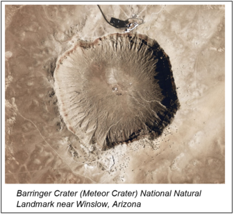
Most meteorites are small and do little harm to the Earth’s surface on impact. Large meteorites, on the other hand, can be very destructive. To see the impact of a large meteorite, search the internet or travel to Winslow, Arizona, to see National Natural Landmark Barringer Crater or, as most people know it, Meteor Crater. The meteorite that impacted this site is estimated to have been approximately 0.6-miles wide! The crater is approximately 3,900 feet in diameter and 560 feet deep.
|
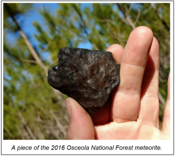
What about meteorites in Florida? According to the Meteoritical Society’s online Meteoritical Bulletin Database, six meteorites have fallen on the state. The database records the meteorite’s name, confirmation status, year, state, meteorite type, weight, and an approximate map location. The oldest observed meteorite in Florida fell in 1916 in the Orlando area and was estimated to weigh 1,000 grams (2.2 pounds). The most recently observed meterorite fell in 2016 in the Osceola National Forest area and was estimated to weigh 1,099 grams (2.4 pounds).
For more in-depth information on meteorites or to visit the online database of meteorites, please visit the below websites:
Resources:
NASA – Meteors & Meteorites
The Meteoritical Society – Meteoritical Bulletin Database:
Contact: Clint Kromhout, P.G. Administrator
Back to top
|
Geologic formations are the basic rock units used in stratigraphy, the branch of geology that deals with the layers of sedimentary rock (called strata) that have accumulated over geologic time.
In 1889, U.S. Geological Survey geologist Frank Burns visited several localities on the Chipola and Apalachicola rivers and made collections of the fossils that were eroding out of the riverbanks. He used the name Chipola marl in his field notes to refer to the geologic stratum containing the fossils. Since then, numerous geologists and paleontologists have worked on various aspects of the Chipola formation, with most of the attention focused on the diverse and well-preserved fossil mollusks it contains. Fossils are important components of geologic units, but they should not be used to define a lithostratigraphic unit (formation). Lithostratigraphic units are bodies of rock or sediment defined and recognized by the kinds of rocks and minerals they are composed of. Like many of Florida’s fossiliferous formations, the Chipola formation was originally defined by the fossils it contains. As a result, it should be considered an informal lithostratigraphic unit.
The Chipola formation was deposited during the early Miocene Epoch (~18 million years ago) based on fossil and geochemical evidence. It is primarily a subsurface unit that occurs in the Florida Panhandle from the Apalachicola River west into southern Walton and Okaloosa counties. It is not usually visible at the surface, but it is exposed along the Chipola and Apalachicola rivers. Here, it consists of a bluish-to-white, fossiliferous, carbonate cemented quartz sand.
|
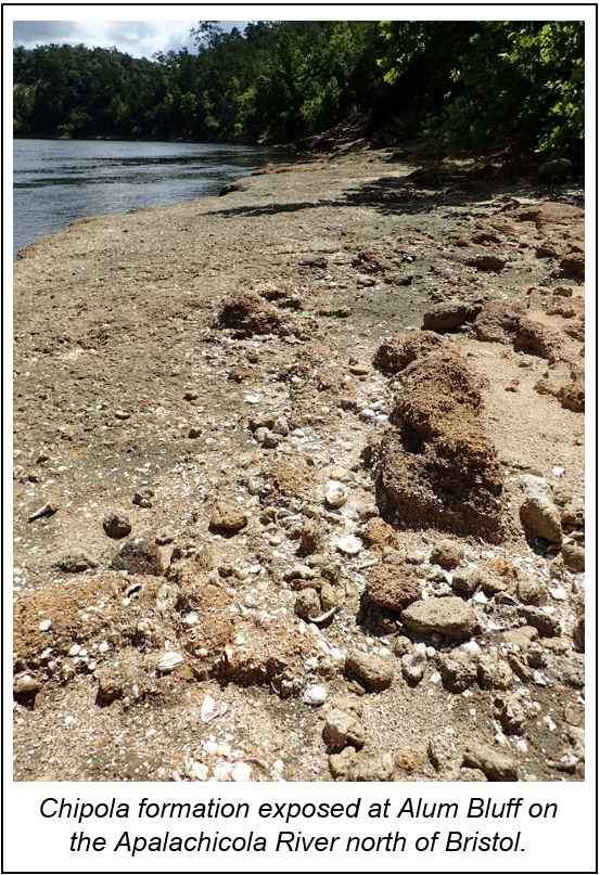
Unfortunately, the lithology of the formation is highly variable and can change over short distances, making the identification of this formation difficult without the use of fossils. The shallow, warm, nearshore marine environments that existed while the Chipola formation was being deposited included coral reefs, tidal flats, tidal channels, and beaches. The diversity of environments within a relatively small area was responsible for creating the complex rock and sediment types that compose the Chipola formation.
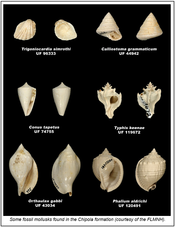
One of the most remarkable things about the Chipola formation is the number of different kinds of fossil mollusks found in it. It has been estimated that more than 1,100 different species of mollusks occur within the Chipola formation, making it one of the most diverse fossil deposits in Florida (Vokes, 1989). This is largely due to the tropical conditions that existed 18 million years ago in north Florida. The Chipola Formation represents the last time tropical conditions existed in north Florida. Modern tropical marine environments contain similar numbers of species and are used as analogs for some of the ecosystems represented in the Chipola formation.
Contact: Harley Means, P.G. Administrator
References:
Vokes, E.H., 1989, An overview of the Chipola formation, northwest Florida, Tulane Studies in Geology and Paleontology, Volume 22, Number 1, pp. 13 – 24.
Back to top
|
Geologic maps show the distribution of different rocks and sediment at the Earth’s surface. They can also show the locations of geologic structures, like folds and faults, as well as other features. Land-use planners, water managers, mineral-resource companies, and local, state and federal government agencies use geologic maps as a primary source of geologic information. As we confront the challenges of sea-level rise, geologic hazards and the need for additional water and mineral resources, having an accurate and refined surficial geologic map will become increasingly important to improve public health, safety and welfare.
Geologic mapping is a core function of state geological surveys. The Florida Geological Survey was established in 1907 and produced the first statewide surficial geologic map in 1909 at a scale of 1:1,000,000 (Matson et al., 1909). Since then, additional updated versions have been produced and published in 1929, 1945, 1959, 1964 and, most recently, in 2001. Updates contained additional data that were generally collected by field geologists who worked newly acquired cores and cuttings and observed the limited number of outcrops and exposures in Florida.
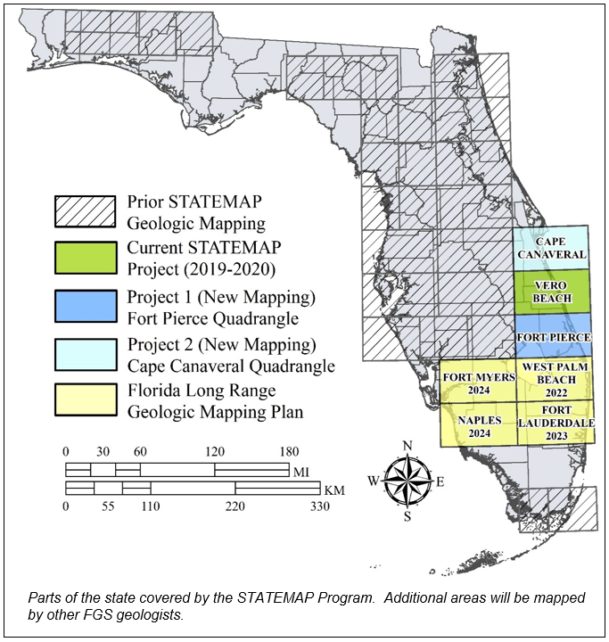
The FGS has recently focused more staff and resources on both surficial and three-dimensional geologic mapping with a goal of updating the statewide surficial geologic map of Florida by 2026. The newly created Florida Geological Survey Mapping Initiative will utilize our ongoing STATEMAP Program as well as additional staff who will work to maximize surficial geologic mapping efforts. To date, the STATEMAP Program has mapped approximately 54% of the state and will continue to map 1:100,000 scale quadrangles each year. Other FGS geologists will map parts of the state not covered by STATEMAP. The surficial geologic map of Florida will contain more than 26 years of new and reinterpreted geologic information and will benefit from recently acquired, highly accurate elevation models (LiDAR based). Additionally, GIS software that was unavailable in 2001 will allow the FGS to utilize the large quantities of geologic data needed to complete the new map.
Contact: Harley Means, P.G. Administrator
References:
Matson, G.C., Clapp, F.G., and Sanford, S., 1909, Geologic and topographic map of Florida, in: Florida Geological Survey Second Annual Report 1908-1909, 299 pages.
Back to top
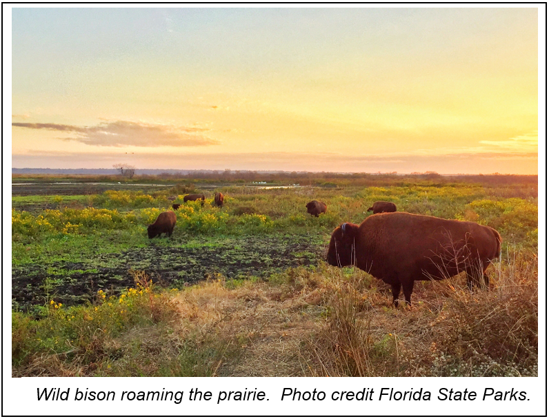
Most people who visit Paynes Prairie Preserve State Park are surprised to discover that a place labeled a prairie with herds of bison and horses roaming free is at times completely submerged by water. In fact, the water was deep enough to support travel by paddle-boat ferries from 1871 to 1891. The prairie nearly became a permanent lake and was even given the name Alachua Lake. However, the lake has never been permanent due to the prairie’s geology.
Separated from land surface by only 20 to 50 feet of clayey sands to sandy clays, limestone
(called the Ocala Limestone) is near land surface at Paynes Prairie. Limestone is a sedimentary rock made up of calcium-carbonate, which comes from skeletal and algal fragments of marine organisms. As rainwater infiltrates into the subsurface, naturally occurring weak acids slowly dissolve the limestone. Once the water reaches the Ocala Limestone, it becomes part of the Floridan aquifer system, Florida’s primary source of drinking water. Water prefers an unobstructed flow path, so it will travel along fractures and beds within the limestone, preferentially dissolving the rock. Over time, dissolution (a chemical process) will cause cavities to form within the limestone. When the cavities become large, the limestone’s ability to hold up the clayey sands and sandy clays above it is weakened. If the cavity collapses, a sinkhole is formed at land surface. This process forms a special topography called karst.
Land forms common in karst regions include sinkholes, caves, springs, and disappearing and reappearing streams. Peering north from the park’s observation tower at the visitor center, one will observe that the prairie is in part a marsh. The prairie’s topography is on average lower than the areas surrounding it. This is due to the dissolution of the Ocala Limestone below the prairie and the lands surrounding it containing thicker sequences of clay protecting limestones below from dissolution.
Traveling to the northside of the park, one can hike several trails, one of which (the La Chua Trail) takes hikers by Alachua Sink. Alachua Sink is a large sinkhole in the bottom of Paynes Prairie. The sinkhole is generally covered by water and not directly visible. Occasionally, however, sediments partially plugging the bottom of the sinkhole will unclog and flush most of Paynes Prairie’s marsh water into the subsurface. This scenario occurred in 1891, allowing bison and horses to roam the prairie.
Contact: Clint Kromhout, P.G. Administrator
Back to top
|
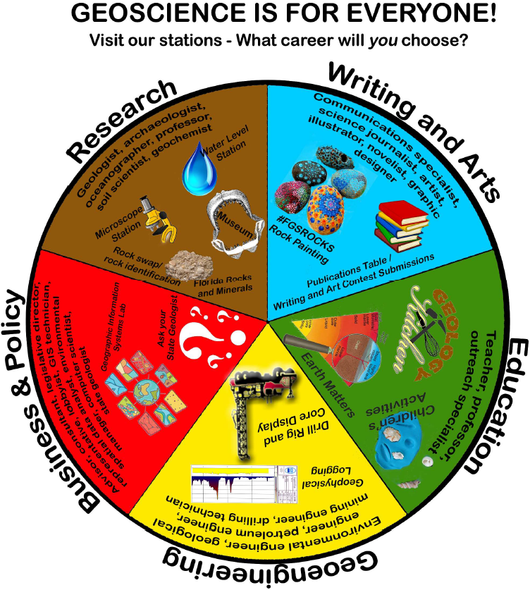
On the chilly morning of Friday, November 1, FGS employees and high school volunteers eagerly set up their learning stations in anticipation of the largest-scale outreach event of the year. The theme of the Open House was “Geoscience is for Everyone,” in keeping with the theme of the American Geoscience Institute’s 22nd Earth Science Week celebration in October. Nearly 250 visitors from all over the state walked the halls of the FGS to discover their path to a career in geoscience. A “career wheel” (above) highlighted learning stations and how they can lead someone to employment in Research, Writing and the Arts, Business and Policy, Education, Geoengineering, and much more. Guests included first- and second-graders from Gilchrist Elementary School and students from the Magnolia School, as well as home school groups from the region.
|
Outside, visitors enjoyed a drill rig and core display and were able to watch a geologist conduct geophysical logging and water level readings from a deep well, one of two wells on-site at FGS headquarters. Water Ventures – Florida’s Learning Lab, a traveling science center, provided educational exhibits both outside and inside the 53-foot vehicle.
Upon entering the building, guests were greeted in the museum, where they viewed the FGS collection that showcases our state’s unique geology. Guests also enjoyed seeing an extinct mako shark jaw and a dugong skeleton. Visitors got a crash course in Florida’s native rocks, minerals and fossils at the Florida specimens table. The always-popular “young geoscientist activity room” showcased smiling children making fossils using shells and Play-Doh. Curious minds visited the “Ask the State Geologist” booth, explored magnification of various rocks and minerals with microscopes, and learned about 3D visualization of geological data in the FGS GIS Lab. And of course, the #FGSRocks campaign continued as guests painted their own rocks to participate in the interactive hide and seek game.
|
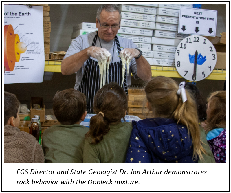
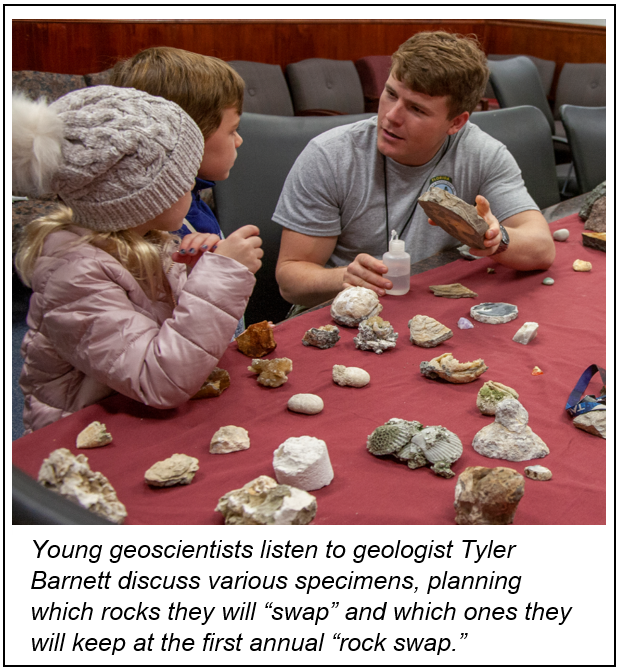
New stations for 2019 included a “rock swap” and the FGS Publications booth, where guests could view and obtain copies of some of FGS’ publications, including bulletins and posters. Sixth- through ninth- grade students provided their submissions to win a “prize that rocks” in FGS’ second annual writing and art contests, which focused on the topic of “Earth Science and Me.” In the “Geology Kitchen,” children and young adult volunteers were invited to participate in demonstrations of the rock cycle using food with FGS geologic “chefs.” The product was an educated audience along with an odd mixture of melted chocolate, gummy worms and crumbled graham crackers that had undergone pressure and heat. “Earth Matters” was another station that made its debut, which involved a demonstration of physical and structural properties in the Earth. Thanks to a combination of water and corn starch, known as Oobleck, students were engaged in discussions of viscosity, brittle and ductile rock behavior.
Each year at this event, educators are provided with AGI teacher kits, rock kits, posters, and other resources to use in their classrooms. Visitors are also provided with giveaways.
Contact: Sarah Erb, Operations Manager C
Back to top
|
The Florida Geological Survey, established in 1907, was housed during its first year in an unused committee room at the Old Capitol building in Tallahassee. The mission of the Survey at the time was to conduct a geological survey of the state. Periodic reports on the progress of investigations included full descriptions of surveys and explorations, occurrences and locations of minerals and other deposits of value, surface explorations, and surface and subterranean water supply. The reports also included analyses of sediments, minerals and mineral waters with maps, charts and drawings. To gather this information, the State Geologist conducted field work, performed surveys, and collected additional information from other interested parties and researchers. Geologic tools used during the early 20th century included rock hammers, hand augers, surveying equipment, and photography. Early field data collection was accomplished by using field notebooks. Reports of investigations were compiled from these field notebooks and other correspondence and materials.
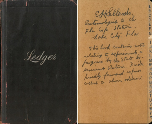
The oldest field book on record at FGS is by E.H. Sellards prior to his tenure as State Geologist. With entries dating from 1905-1906, the inside cover includes the following text: “E.H. Sellards, Entomologist to the Fla. Exp. Station, Lake City, Fla. This book contains notes relating to experiments in progress by the State Experiments Station.” In this field book, Sellards lists outcrops and formations in alphabetical order, along with their locations. The book also includes Sellard’s travel journal from when he was examining the outcrops.
|
|
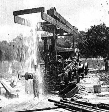
Photo of a flowing artesian well - Palatka, Florida. (Used in FGS Annual Report 1) – photo by E.H. Sellards. Photo ID: GE0188, 1908. The Florida Geological Survey has a collection of historic photographs shared through the State Library and Archives. Additionally, The FGS has added nearly 8,000 photos and slides and posted them to its Resource Space page.
|
|
 |
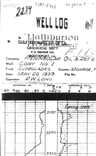
As time went on, field data collection methods improved. Although a field notebook and camera were still the mainstays, enhancements in exploratory drilling allowed for complete sample collection and retrieval of samples from greater depths. The late 1920s saw the introduction of geophysical logging tools in the United States, and by 1939, the technology made its way to Florida. The first geophysical log submitted to the FGS belongs to an oil and gas well in Monroe County (pictured to the right). The addition of new mapping and navigation techniques along with aerial imagery aided researchers in their efforts to map the state.
To date, the FGS has a collection of nearly 19,000 geophysical logs associated with more than 5,400 boreholes. To access these log images today, visit the FGS website and look them up by county. Interested parties can also go to DEP’s interactive map site called MapDirect to search for records. The FGS archives an additional 4,700 oil and gas geophysical logs across the state associated with 1,110 active oil and gas permits. Images of those logs are located on the FGS ftp site.
|
Early computers aided geologists and researchers in completing their projects. The earliest computers were used to perform complex calculations and store data. In the late 1970s a database was designed that utilized punch cards, thanks to the programming skills of geologist Jim May. These cards represented data, and the computer systems read the paper cards by the presence and absence of holes punched in predefined positions. The cards stored geologic descriptions for easy indexing and retrieval. In the mid-1980s, a new system based on the punch cards was put into place and the data was stored on hard disks. Through a public-private partnership with Dr. Bob Lindquist of GeoSys Inc., a DOS-based system was developed and used to enter and archive lithologic descriptions (Enterlog.exe) and decode and print those same descriptions (Printlog.exe). Years later, through GeoSys/4G, geologists could plot wells on a map and select them to view lithologic or geophysical logs, and even generate cross sections.
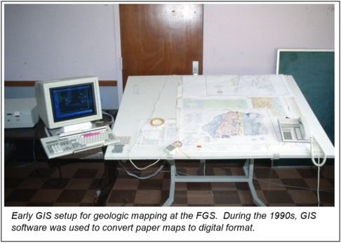
The 1990s also saw the integration of computer-aided design with geologic mapping, which allowed for enhanced map delivery. With the onset of Geographic Information Systems (GIS) software, more efficient field mapping, data collection and dissemination ensued. Geologists quickly realized the potential and picked up the skills necessary to use the software and create high-quality georeferenced geologic maps. This technology continues to offer ways to visualize and analyze geological data. Geologic data for Florida can be found at DEP’s Open Data Portal.
By the turn of the century, the FGS developed within Microsoft Access a database system to store geologic data. This data system retained the GeoSYS/4G data structure to more efficiently import legacy data. Today, the FGS has GEODES (Geologic Data Management Enterprise System), a cloud-based Software as a Solution (SaaS) product. With help from other DEP staff and our contractor, Kyra Solutions LLC, FGS now utilizes this off-the-shelf customized solution, effectively replacing the need for the Microsoft Access database system.
|
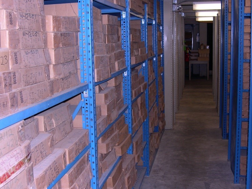
Today, the FGS has an entire section devoted to data management where staff members oversee the collection, storage and discoverability of data. This involves locating and accrediting all geologic information from historical and current projects. It includes indexing, cataloging and authentication of data and samples in the Florida Geological Sample Repository. The Geologic Information and Data Management section is integral in all aspects of data collection, organization and visualization. Just last year, the FGS was able to complete a full inventory of its sample repository in Tallahassee, which contains samples from a well dating back to a well drilled in 1886. The job took a full year to complete and thousands of staff hours. The section built a Survey 123 for ArcGIS application to accomplish this. Teams of two dispatched to the repository to inventory each box with tablets to use this form-centric solution. All total, FGS staff confirmed the location and condition of over 74,000 boxes of samples at the repository. From the inventory, geoscientists are better able to account for sample types, condition and availability.
FGS geoscientists regularly use DEP resources to develop new field mapping tools and conduct fast data acquisition as well as on-the-fly data collection from custom applications. The largest data producer at the FGS is provided by the STATEMAP program. Each year, this team maps up to 2,100 square miles as part of a grant through the National Cooperative Geologic Mapping Program, which is administered by the U. S. Geological Survey. To facilitate this activity, the team requires access to vetted and reliable borehole descriptions as well as availability of quality samples to describe. The team also must collect large amounts of data on the fly while performing fieldwork. This includes quick feature identification, collection and navigation. To accomplish this, the GIS department of DEP assisted the FGS with building a new application called FDXplorer, part of the Collector for ArcGIS toolset. This is a versatile data collection app that works with mobile devices, allowing for the capture and editing of data on or offline and integrates with ArcGIS.
Contact: Alan Baker, P.G. Administrator
Back to top
|
|