|
Greetings, and welcome to the Fall edition of FGS News and Research. With this being the last newsletter of 2017, I would be remiss if I didn’t mention that this year marks the 110th anniversary of the Florida Geological Survey! Since 1907, FGS staff have been disseminating quality geologic information about Florida to our customers across the state and the globe. Our institution has been around this long because the need for applied geological study does not ever let up. Whether our activities involve our core mission, such as providing increasingly detailed surface and subsurface geologic mapping, or conducting research to guide environmental policy and offer solutions to environmental problems, there is plenty to accomplish as we serve our state of nearly 21 million people.
Geoscience is in the hearts and minds of staff at the Florida Geological Survey. This October, we again celebrated Earth Science Week and through our Open House, as well as the Florida Caverns Cultural Celebration and the Tallahassee Science Festival, we reached more than 850 citizens, promoting environmental understanding and stewardship through the geosciences. Recent media coverage of our museum and local geoscience outreach on water level fluctuations in Lake Jackson (Leon County) hydrology was welcomed.
Learning never stops at the FGS (read about my visit to China below), and we invite you to join us as we explore the Ocala Limestone in our featured formation article. Additionally, join us as we explore ground penetrating radar in this edition's GEOFACT. Finally, discover how geologists use reference samples to do their work, and what we have planned for our FGS Reference Sample Collection in the future.
We cannot do our work without the support of our customers – the citizens of Florida. Therefore, I invite you to revisit our communication sent to you on October 26 regarding the STATEMAP Statement of Outcome. Please contact me by calling 850-617-0320 or email me at Jonathan.Arthur@dep.state.fl.us if you wish to support our mapping program by sharing how our work has benefited your agency or company’s mission, goals or objectives.
Sincerely,
 Jonathan D. Arthur, Ph.D., P.G.
Director and State Geologist
Florida Geological Survey
Florida Department of Environmental Protection


Imagine that you are on a hike and see someone with what looks like a push mower. The person is moving very slowly, staring at a screen, and the “mower” is not making any noise or cutting grass. You may have just seen a geologist or engineer using ground penetrating radar (GPR).
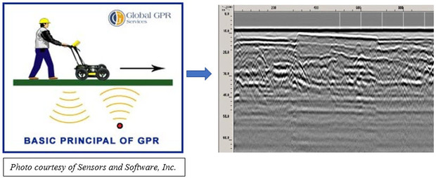
GPR is an instrument that uses pulses of electromagnetic energy in the form of radio waves to measure physical properties of the materials and structures below it.
The GPR tool detects the radar signals as they reflect off subsurface materials and structures. The collection of those reflected radar signals creates an image called a radargram, which can be used to interpret what is “seen” in the subsurface. When an object or horizontal reflector is imaged, but the surveyor does not know what the reflector is, that reflector is referred to as an anomaly. The identification of anomalies is a standard practice in GPR surveys (see figure below. All labeled items are anomalies).
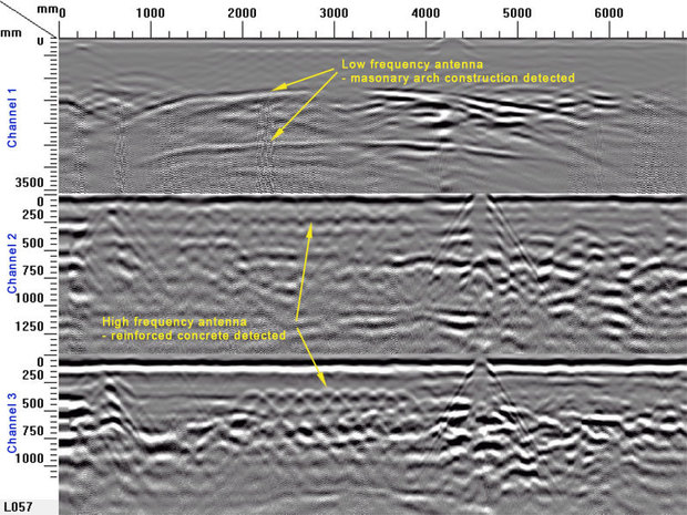
GPR can be used to detect buried structures such as plastic, metal or concrete utility pipes, or even metal objects like cables, barrels or paint cans. Geologists use GPR to identify rock or sediment layers, saltwater-freshwater interfaces or voids. If soil has been disturbed by excavation or back filling, geologists can interpret these areas with data generated from the GPR survey. GPR can also be used to measure thicknesses of geologic layers or known objects such as road pavement and building foundations.
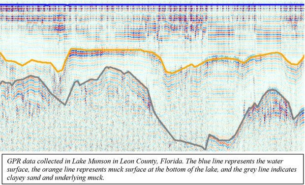
Many people wonder how far into the earth GPR will allow us to see. Unfortunately, there is not a simple answer to this question, as it depends on the composition of the subsurface materials and frequency of the antenna being used. The higher the frequency of the antenna, the shallower the penetration of the radio waves and the smaller the potential targets that can be imaged. The lower the frequency of the antenna, the deeper the penetration of the radio waves and the larger the object must be to be imaged. Because both freshwater and fiberglass are transparent to the radio waves used, GPR can be used in lakes, as shown in the illustration below.
While this technology is extremely useful, it is not without its limitations. For example, GPR does not work in areas where highly conductive materials or fluids exist through which radio waves cannot penetrate. This means that the GPR cannot display what is below those layers. Metals, clays and saltwater are examples of materials through which the radio waves cannot pass.
Contact: Casey Albritton, Geologist III

You may recall from our Spring 2017 edition that geologic formations
are the basic rock units that are used in stratigraphy, the branch of geology
that deals with the layers of sedimentary rock that have accumulated over
geologic time (also known as “strata”). Formations are defined by the geologic
materials, or lithology, that comprise a rock layer. In the Summer 2017 edition, we closely examined the
Anastasia Formation, which is found on Florida’s East Coast. In this issue, we
now turn to the Ocala Limestone, which is both an important economic and
natural resource.
The Ocala Limestone,
named in 1892 by W.H. Dall and G. D. Harris of the U. S. Geological Survey,
gets its name from the highly fossiliferous limestone that is exposed in
quarries near Ocala, Florida. The Ocala Limestone underlies most of Florida and
comprises an important part of the Floridan aquifer system, which provides
drinking water to millions of Floridians. It attains a maximum thickness of
over 800 feet along the coastal parts of Gulf and Franklin counties. In parts
of the state where the Ocala Limestone is near the land surface, it is mined and
used as aggregate in cement production and is also used as an additive in some
pharmaceutical products.
When the Ocala Limestone
was deposited between 37.8 and 33.9 million years ago, during the late Eocene
Epoch, Florida was submerged beneath a warm, shallow ocean. The remains of mollusks, echinoids,
foraminifera and other marine organisms that lived in this region accumulated
on the sea floor as sediment. Over geologic time, the sediment became
compressed and cemented to form limestone.
The Ocala Limestone is one of many limestone units that comprise the
Florida Platform, which is roughly twice the size of the modern emergent Florida Peninsula and is underlain by as much as 10,000 feet of limestone, in places.
|
The Ocala Limestone is a
cream to white colored, chalky, highly fossiliferous limestone. It contains
very few impurities like quartz sand, clay or heavy minerals, which makes it
easy to distinguish from younger, less pure limestone deposits. The Ocala Limestone is also distinguished from
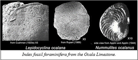
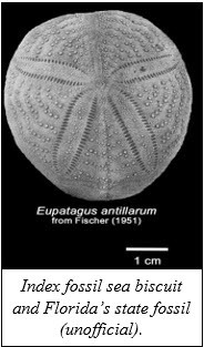
other stratigraphic units in Florida by the fossils contained in it. Specifically,
it contains index fossils, which are fossils that help identify a specific
geologic unit or geologic time period, including the foraminifera Lepidocyclina ocalana and Nummulites ocalanus, and the sea
biscuits Oligopygus wetherbyi and Eupatagus antillarum. Other less common fossils
found in the Ocala Limestone include the teeth and bones of whales, dugongs
and sharks. By studying the fossils contained in the Ocala Limestone, geologists
have a better understanding of what the conditions were like in Florida more
than 34 million years ago.
|
 The Ocala Limestone crops out along Florida’s Big Bend coastline from Dixie to Hernando counties and is at or near the surface in much of Gilchrist, Alachua, Marion and Sumter counties. In the Panhandle, it is found near the surface in northern Jackson and Holmes counties. Throughout the rest of the state, the Ocala Limestone is either a subsurface unit or is absent. Where the Ocala Limestone is near the surface, there are numerous karst features, including sinkholes, springs and caves that have developed as the limestone has weathered and dissolved over millions of years. Karst features are a good place to see the Ocala Limestone when you are ready to get outside and explore this fascinating formation.
Contact: Harley Means, P.G. Administrator
Back to top
|
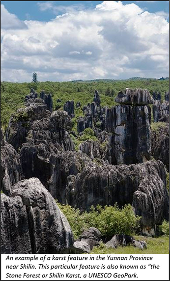 Dr. Jon Arthur, State Geologist and Director of the FGS, gave three lectures in two cities in Southern China on karst geology, sinkholes and aquifer vulnerability at the end of July. Dr. Arthur was invited to present “The Nexus between Environmental Policy and Karst Research in Florida” at Hohai University in Nanjing, China, as well as at the International Research Center on Karst 2017 Training Course on Karst Hydrogeology, Environmental Geology, and Ecological Geology in Kunming, China (IRCK Training Course). Karst aquifers yield 25 percent of water to the Earth’s population. These aquifers are highly complex and vulnerable to contamination.
The FGS Director also presented “A Review of Hydrogeology and Ecosystem Restoration Plans for the Edwards Aquifer, Texas” at the IRCK Training Course. He serves on a National Academy of Sciences Committee focusing on the Edwards Aquifer, which is similar to the Floridan Aquifer. An additional presentation, “Summary of Karst Critical Zone Research in the United States,” was provided by Dr. Arthur for a meeting of the UNESCO International Geoscience Programme Project 661 - The Critical Zone in Karst Systems.
The FGS Director joined 60 participants from 16 countries in the IRCK Training Course where karst engineering for economic sustainability was demonstrated. This included a three-day Karst Field Trip in Luxi County, Yunnan, China, observing karst and karst engineering for economic sustainability.
The exchange of information during this trip provided an opportunity to learn more about the scientific challenges regarding karst worldwide. Dr. Arthur also met with IRCK Deputy Executive Director Dr. Jianhua Cao to discuss cooperative opportunities between the Center and the FGS.
Dr. Arthur has over 30 years of knowledge and research experience with the Department, starting at the Florida Geological Survey in 1984 as a research assistant. “It was an honor to be chosen as a lecturer for this international course and to speak at Hohai University and a meeting of the UNESCO International Geoscience Programme on the Critical Zone in Karst Systems,” Dr. Arthur said. “This was a wonderful opportunity to share the Department’s knowledge of karst geology in Florida and gain a wealth of knowledge to bring back to Florida from international experts.”
More than 90 percent of Florida's drinking water comes from Florida's aquifers, most of which are karst-related. The information shared and obtained benefits Florida and its citizens through improved knowledge of karst geology, which is prevalent in the state.
Contact: Sarah Erb, OMC Manager
|
In
celebration of the 20th annual Earth Science Week, the FGS held two
days of events at our headquarters. The theme this year was “Earth and Human
Activity.” On Thursday, Oct. 12, fourth-grade science students from Cornerstone
Learning Academy visited the Walter Schmidt Museum of Florida Geology, and
Professional Geologist Administrator Harley Means led a field trip to Leon
Sinks Geological Site, which was open to the public.
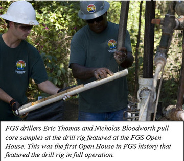
On
Friday, Oct. 13th, the FGS opened its doors to the public for an Open House from 10 a.m. until 3 p.m. A geologic time scale chalked on the
front driveway welcomed guests as they arrived, along with a fossil dig for
children, educational brochures and friendly engaging staff. The FGS mobile drill rig was set up outside
and for the first time in FGS’ Earth Science Week history, was drilling core as
part of a “live” demonstration. Upon entering the building, guests were greeted
in the museum, where they
viewed the FGS collection that showcases our state’s unique geology and got a
crash course in Florida’s native rocks, minerals and fossils. Guests also
enjoyed viewing the extinct mako shark jaw, as well as the dugong skeleton.
Indoor
learning stations included an activity room where younger guests could make fossils
using shells and Play-Doh, and fulfill curious questions at the “Ask the State
Geologist” station. Guests of all ages enjoyed exploring magnification of
various rocks and minerals with microscopes, as well as learning about sample
processing and 3-D visualizations of geological data. Some guests even brought
their own rocks and minerals to be identified. Educator packets were provided
to teachers, courtesy of the American Geological Institute. Those who visited now have a better
understanding of why the FGS mission is important to the state.
October
is the busiest month for outreach and education at the FGS, largely due to the events
which surround Earth Science Week. In addition to the Open House, FGS employees
were able to reach 853 citizens during the month of October thanks to local
events like the Cultural Caverns Festival, Tallahassee Science Festival, field
trips for various local groups and Florida geology presentations.
Contact: Sarah Erb, OMC
Manager
|
Identifying geologic
formations is a task that many geologists must perform. Geologic formations are
identified by their lithologic components. When formations are defined, the
lithologic variability within the unit is described and a type section is
proposed. A type section is a geologic
outcrop from which a formation is defined and is a place where other geologists
can compare samples from other areas to see if they match the defined
lithologic character of the formation.
In areas where there is low topography, or when geologic formations are
not exposed at the surface, a core or several cores may be designated that
represent the type lithology of the defined formation.
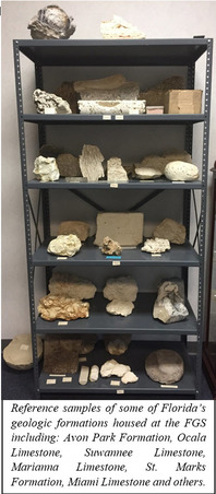 Type sections are often located in places that are not easily accessible to most geologists (remote locations or located on private land). Type cores are usually stored in sample repositories and may require special assistance and permission to access. Therefore, it is useful to have a set of reference samples located in one place where geologists can see representative examples of the geologic units that occur in an area. The Florida Geological Survey maintains a large repository containing more than 19,700 sets of samples from around the state, but they are comprised of cuttings or small diameter cores. These samples collectively provide the basis for our geologic understanding of the state, but individually each set of samples or each core is not as useful in helping geologists recognize the various geologic formations that occur in Florida.
The Florida Geological Survey has been working on building a collection of geologic samples from geologic formations that occur at or near the surface from around the state. The samples, when possible, are collected from type sections or from outcrops that contain good examples of a formation. These reference samples will be useful to geologists and interested members of the public who do not have time to visit type sections or examine type cores. The sample collection will provide them with an opportunity to examine larger specimens that show the lithologic variability within a given formation (as opposed to cuttings or a small-diameter core). These samples are housed in the Walter Schmidt Museum of Florida Geology at the FGS. The FGS plans to expand, catalog and photograph the samples and make the images and information about them available on our website. The samples are accessible to the public during working hours (M-F 8 a.m. to 5 p.m.) by appointment.
Contact: Harley Means, P.G. Administrator
Back to top
|
|