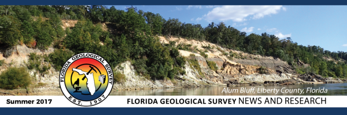
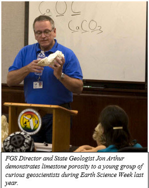
 Welcome to the Florida Geological Survey’s (FGS) News and Research Summer 2017 Edition. As Florida’s premier state government institution specializing in geoscience research and assessments, the FGS receives a multitude of requests for data, research collaboration and advisory assistance. In this issue, I welcome you to read more about what I do as FGS Director and State Geologist of Florida. Of course, I could not do this effectively without the incredible geoscientists and administrative team at the FGS. Recently, one of our outstanding employees, Environmental Specialist Levi Hannon, was presented with a DEP Star Award for his innovative development of a method for organizing digital geoscience data, making it easier to integrate into our master database. Levi’s work enables FGS geologists to increase efficiencies in data access and interpretation. Additionally, Levi helped propose a new accelerated geologic mapping program at the FGS and launches the Florida GeoSites website.
Also in this issue, join us as we also explore vibracoring and the application of these important samples to address environmental concerns. Discover the Anastasia Formation in our new feature, “Formation of the Quarter,” and learn about the wealth of knowledge FGS recently gained from geophysical tool systems training.
Finally, I am excited to announce completion of two important projects. First, as part of a pilot study conducted for the Florida Fish and Wildlife Conservation Commission, FGS staff located and verified 27 previously uncatalogued springs in the Big Bend Wildlife Management Area. Second, the Florida LiDAR Assessment is completed and available upon request. Read more about both of these contributions below!
Sincerely,
|
 Jonathan D. Arthur, Ph.D., P.G.
Director and State Geologist
Florida Geological Survey
Florida Department of Environmental Protection


The
irreplaceable well samples at the FGS Geologic Sample Repository have been an
important part of Florida’s economy and academic community for over 100 years. This wide assortment of soils, clays, continuous rock cores, vibracores
and drill cuttings tell many stories and serve multiple purposes. One interesting
example of an often overlooked sample type that provides multiple
services for Floridians is vibracores. These samples provide a public service
when they are studied for beach re-nourishment projects, support academia in
multiple aquatic and terrestrial studies, and encourage interagency collaboration
throughout different departments of the DEP through group field collaborations and
advanced data management.
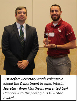
Vibracore
samples are composed of unconsolidated or loose materials such as organic-rich
sediments, sands and clays. Depending upon the point of collection, they may contain
marine elements such as mollusk shells and worm rock. Additionally, they can include microfossils, important minerals and trace elements of
anthropogenic pollutants that have made their way into protected environments. The
collection of the vibracore sample type is conducted by attaching an all-in-one
adjustable plate, head and bolt set known as a Rossfelder unit onto an
aluminum tube which is then advanced into the collection zone via the rapid
vibrations generated by the Rossfelder unit. Energy for the Rossfelder unit is
provided by a small engine similar to a water pump. The same principle is also
applied on a larger scale on sea going vessels with similar equipment to
collect sediments in deep-sea environments. As the name of the sample type suggests,
the specimen collection tubes are literally vibrated into the sands and other
sedimentary strata that may be of interest. Before sampling begins, a plastic
net-like set of teeth is placed in the bottom of the collection tube to prevent
loss of sample when the collection tube is being extracted. Other factors contributing
to successful sample collection include caps, highlift jacks and rounded
clamps that fit snugly around the collection tube to assist with sample
extraction.
The
practice of vibracore sampling has enabled organizations such as the National
Oceanic and Atmospheric Administration and the United States Geological Survey to
obtain samples from extreme environments such as Antarctica. Vibracoring is a
practical method used for collecting samples in all kinds of areas and remains
an important part of the methods and practices of the FGS. Recent examples
of FGS vibracoring projects include acquisition of sediments from Lake Munson
in Leon County, terrestrial sampling at the Letchworth Native American mounds
in Leon County, sample collection at Keaton Beach for dredging-related
projects in Taylor County, collaborative sampling with students from FSU, and
processing archival projects with submerged lands. With the ability to be
applied in almost any environment, vibracoring can be a useful and cost-effective
sampling method for projects that are looking at unconsolidated stratigraphic
materials. Vibracore samples are important specimens within the FGS Library and
they help to provide us with a useful source of data that can help to fulfill
the FGS mission statement of collecting and interpreting Florida’s unique
geology.
Contact: Jesse Hurd,
Laboratory Technician
|
You may recall from our Spring
2017 edition that geologic formations are the basic rock units that
are used in stratigraphy, the branch of geology that deals with the layers
of sedimentary rock that have accumulated over geologic time (also known as
“strata”). Formations are defined by the geologic materials, or lithology, that
comprise a rock layer. Let’s closely examine one particular formation, the
Anastasia Formation, which is found on Florida’s East Coast.
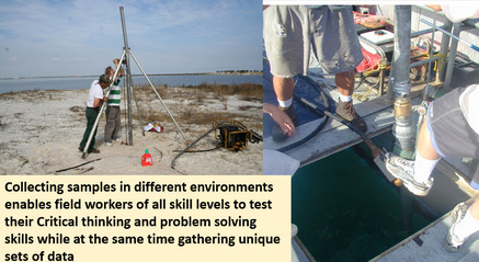
If you have ever visited
St. Augustine, you have probably seen the Castillo de San Marcos, the old
Spanish fort that has stood the test of time and attack for over 300 years. The
shell rock that makes the Spanish fort so strong, coquina, is an example of the
Anastasia Formation, which is primarily comprised of quartz sand and seashells
that have been cemented together. The Anastasia Formation was
deposited 83,000-118,000 years ago, based upon radiometric dating
(Osmond et al., 1970). The lithology is recognizable and occurs over a large
enough area that it can be depicted on geologic maps of various scales. The
Anastasia Formation is a formal lithostratigraphic unit because its lithologic
character has been described and the extent of where this formation occurs,
both laterally and vertically, has been mapped and defined.
The Anastasia Formation was named in 1912 by Elias Howard
Sellards, the first State Geologist of Florida.
It occurs from St. Johns to Palm Beach counties (Scott et al., 2001)
along the east coast, and extends inland up to 20 miles. It underlies the Atlantic Coastal Ridge in
this area. The formation is up to 100 feet thick in places, and is mainly
comprised of coquinoid limestone in the coastal exposures. In the subsurface,
the Anastasia Formation can be comprised of unconsolidated shell and shelly
sands of near shore marine facies (Parker et al., 1955).
|
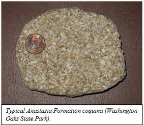 The term facies is used by geologists to describe differences in the lithology of a formation. Two distinct facies of the Anastasia Formation were recognized by D. W. Lovejoy in a 1987 Miami Geological Society Memoir. These differences are related to different environments that existed while the Anastasia Formation was being deposited. The coquinoid limestone facies consists of calcite-cemented whole and fragmented mollusk shells, varying percentages of quartz sand, and a small percentage of heavy minerals. The shellrock facies, the second recognized by Lovejoy, contains mollusk shells that are less fragmented and not as well cemented as the coquinoid limestone. (Lovejoy, 1987).
The Anastasia Formation was deposited in Florida during the last interglacial period when sea levels were 5-7 meters higher than today. The unique lithologic character of the Anastasia Formation was recognized and exploited by the Spanish and was probably the first stone building material used in the New World by Europeans. The Anastasia Formation coquina was soft enough to easily quarry and was durable enough to use in construction. The Castillio de San Marcos in St. Augustine has stood the test of time, due in part to one of Florida’s unique geologic formations.
Contact: Harley Means, P.G. Administrator
REFERENCES:
Lovejoy, D. W., 1987, The Anastasia Formation in Palm Beach and Martin Counties, Florida, Miami Geological Society Memoir 3, pages 58-72.
Osmond, J.L., May, J.P., and Tanner, W.F., 1970, Age of the Cape Kennedy barrier-and-lagoon complex, Journal of Geophysical Research 75, 469-479.
Parker, G.G., Ferguson, G.E., and Love, S.K., 1955, Water Resources of Southeastern Florida, U.S. Geological Survey Water Supply Paper 1255.
Scott, T.M., Campbell, K.M., Rupert, F.R., Arthur, J.D., Green, R.C., Means, G.H., Missimer, T.M., Lloyd, J.M., Yon, J.W., and Duncan, J.G., 2001, Geologic Map of the State of Florida, Florida Geological Survey Map Series 146, One plate.
Back to top
|
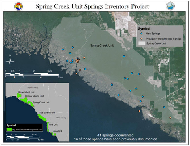 The Florida Fish and Wildlife Conservation Commission (FWC) provided the FGS with $32,000 in contract funds to conduct geospatial analysis, identify potential locations for springs within the Spring Creek Unit, ground-truth and evaluate each potential site, map each spring and conduct water-quality analyses of springs in the five units comprising the Big Bend Wildlife Management Area (WMA). These units, which include Snipe Island, Hickory Mound, Spring Creek and Tide Swamp in Taylor County, and Jena in Dixie County, were the focus of collaborative work between the FWC and the FGS in this pilot study. Funds received covered laboratory analyses, field supplies and travel, with FGS providing matching funds for staff time and field equipment.
The FGS compiled readily-available data on 14 previously cataloged springs (orange symbols), geospatial coverages and potentiometric surface maps for the Spring Creek Unit. Using this information, field data, drone aerial photography and video, and GIS analysis, FGS located and verified 27 previously uncatalogued springs (blue symbols), most of which contain multiple vents. GPS location data, site descriptions, photographs and estimated discharge were recorded for those springs. Water quality samples were collected at eight springs. Four springs had saline influences and four were fresh. One of the springs are estimated to have second magnitude discharge, while the remaining springs are estimated to be third or fourth magnitude springs.
The project was completed in June. The exciting discoveries from this pilot study have sparked interest in further research. FWC has expressed interest in a comprehensive springs survey project for fiscal year 2018-19, which may include contracted flights to obtain thermal imagery data for the four remaining units of the Big Bend WMA, as well as continued field exploration for springs (location, field parameters and water quality analyses).
Contact: Clint Kromhout, P.G. Administrator
Geophysical tools provide
a wealth of geological information, often without any disturbance to a site.
However, collecting quality data from which we can make relevant
interpretations requires competent tool operation and data processing, as well
as in-house expertise. For these reasons,
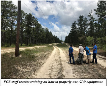
FGS staff recently received training in two geophysical tool systems: ground
penetrating radar (GPR) and borehole logging.
During April, five FGS
staff members and an instructor from MALA Geoscience took GPR equipment
(including unshielded 50 MHz and 100 MHz, and shielded 250MHz and 500 MHz
antennas) to the Apalachicola National Forest south of Tallahassee to train
staff on the operation of all four antennae. This was followed by classroom
instruction on processing the data collected in the field.
GPR works by sending a radio
signal down into the earth and measuring the amount of time it takes for that
signal to reflect off an object or layer and return to the receiver. GPR data
can be used to look for buried objects such as waste drums, underground storage tanks, utilities, evidence
of subsurface disturbance or subsidence and to ensure a drill site is safe
before setting up a drill rig. The data can also be used to estimate sediment
thicknesses, supporting subsurface investigations. For example, during a recent
field trip to Lake Munson to collect a test vibracore of the lake bottom, staff
acquired two GPR transects across the lake.
These transects will be compared to vibracores collected from the lake bottom
to estimate water depth and lake bottom sediment thicknesses, which will
support a potential future cooperative project.
The use of GPR is not the
only skillset learned by FGS staff. Training in the operation of borehole
geophysical tools and the processing and presentation of the data was provided
by an instructor from Mt. Sopris (the manufacturer of the FGS logging system).
Six FGS staff members set up equipment on a Northwest Florida Water Management
District monitor well to train in the operation of the system, which includes
several different probes that collect different types of data. The probes the FGS staff received training on included: caliper, conductivity, resistivity, gamma-ray and electrical resistivity. These tools can
be used to help understand local and regional hydrogeology and assist in
resource management. They can also be used to help define geologic formation
contacts, supporting ongoing geologic mapping projects.
|
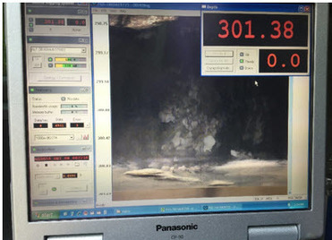 The different logs can give geologists information about the sediments, porosity of the formation, water quality, dimensions of the borehole or well, and even a video log of the well and borehole. In a recent log, a conduit or cavern flow of water beneath the network feeding Jackson Blue Spring at 301 feet below land surface was observed, shown to the left. Caverns such as this one are common in the Floridan aquifer and are part of a large network of conduits through which our groundwater flows, to springs and offshore.
Geophysical tools, coupled with those who know how to use them and process the data, give us an improved picture of our geologic environment in Florida.
Contact: David Paul, P.G. Administrator
|
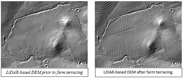
Equipped with funds from
the Florida Legislature, the FGS launched a statewide LiDAR assessment to determine
whether uniform and contemporaneous LiDAR data collection can realize improved
efficiencies in support of 3D topographic elevation needs by local, state and
federal government agencies, as well as private institutions and
companies. The goal of the Florida LiDAR
Assessment is to identify mission critical areas, business uses, resolution
requirements and benefits for topographic LiDAR, bathymetric LiDAR and/or
topobathymetric LiDAR in the State of Florida. Florida is the first state in the nation to conduct this type of assessment
for both topographic and bathymetric LiDAR.
Through a competitive bid process,
Dewberry was awarded the contract and has administered a statewide
questionnaire, compiled responses and developed recommendations that address
technical challenges, risks and benefits. The final report offers the following salient observations: 1) the top
three Florida business uses for LiDAR are natural resource conservation, water
supply and quality, and coastal zone management, 2) the top three 3D
applications of LiDAR are bare earth ground elevations, inland bathymetry and
nearshore (coastal) bathymetry, 3) annual
net benefits of statewide topographic LiDAR are projected to exceed $21M,
with a benefit/cost ratio of 3.7:1, and 4) annual
net benefits of statewide coastal zone topobathymetric LiDAR are projected to
exceed $28M, with a benefit/cost ratio of 5.1:1.
The
FGS is particularly grateful for the support of Al Karlin, SWFWMD, Richard
Butgereit, Florida Division of Emergency Management, and Lou Driber, U.S.
Geological Survey, who along with Jon Arthur and Alan Baker, served as the
Florida Executive Advisory Committee for the study. For more about LiDAR, please see this
article. Contact Dr.
Jon Arthur or Alan Baker if you would like a copy of the Florida LiDAR Dewberry
Report.
Contact: Jonathan D. Arthur, FGS
Director and State Geologist
Back to top
 The leader of the Florida
Geological Survey serves in two capacities: as FGS Director and as the State Geologist of Florida. What are these jobs, how are they related? To understand this, it is important to know
that the mission of the FGS is to collect, interpret and provide objective,
quality information about Florida to its citizens, businesses and
agencies. Dissemination and storage of
geologic data compiled over more than a century is a large responsibility – not
to mention sharing geologic information reflecting the past millions of
years! Because of this, a robust team of
geoscience professionals is needed and the program must be managed by a
Director who can make administrative decisions regarding organizational
structure, budget and priorities, and implement policies. The Director must also provide assistance to DEP
senior management, federal, state and local agencies, and provide industry
representatives and private citizens with information about all aspects of FGS
programs.
Florida Statutes mandate that
the FGS “shall be under the direction of a full-time professional geologist,
who shall be known as the State Geologist.” To lead a geoscience organization,
the FGS Director must have extensive knowledge of Florida geology so that he
can educate citizens and interface with the geoscience community. It is here that the State Geologist role
comes into play. For example, FGS often provides geoscience support to various
state and federal agencies, requiring expertise. The Director and State
Geologist also represents the State of Florida in various media events, including
on television networks, such as The Weather Channel and other major
networks.
Sharing geoscience expertise as
requested and taking part in interviews with the media is not where the role of
Florida State Geologist ends. Representing the State of Florida in the
Association of American State Geologists (AASG) as President (and other
executive roles) requires leadership through service on various executive and
awards committees, as well as presentations to U.S. Senate and House committees
and meetings with federal agencies such as Bureau of Ocean and Energy
Management, National Park Service, and the National Oceanic and Atmospheric
Administration. Additionally, service on various national committees such as
the National Academy of Sciences brings new knowledge to Florida regarding
challenges in water policy and conservation. Statewide, the State Geologist is
expected to serve as Chair of the Big Cypress Swamp Advisory Committee, and as
a member of the Florida Board of Professional Geologists. In addition to this and providing
presentations at various conferences across the state, nation and sometimes
the world (see FGS
Goes to China), it is no wonder that the
State Geologist stays very busy when he is not serving in an administrative
capacity as FGS Director.
Outreach efforts occupy a lot
of a state geologist’s time. Lectures to university students and taking part in
events that educate people of all ages about the geology of Florida are
time-consuming, but very rewarding. Speaking to an Environmental Capstone class
at Florida State University might interest young adults in geoscience careers,
while examining Florida’s rocks and minerals at Tallahassee’s Healthy
Communities Festival with a child and his grandmother might ignite a newfound
passion for geology in the young and old. Facilitating a record-breaking Earth
Science Week Open House last October is another indication that these efforts
are worthwhile to the public.
When the FGS Director and State
Geologist is not traveling, doing interviews or speaking to various groups,
administrative duties in the office range anywhere from making personnel and
budgetary decisions to reviewing manuscripts for peer-reviewed journals. As a
leader and geoscience expert, the FGS Director is in a unique position to take
leadership roles for various initiatives, such as working toward consistent
scientific nomenclature across Florida’s geoscience agencies, initiating a
statewide Light Detection and Ranging (LiDAR) assessment, and coordinating with
DEP District and Division geoscience managers and water management districts.
Of course, the specific duties
and roles are ever-changing for this demanding position, depending on Florida’s
current and upcoming geologic needs. Considering Florida’s growing population
and popularity for tourism, how do you think the focus may shift for the FGS
Director and State Geologist in the coming years?
Contact:
Sarah Erb, OMC Manager
|
|