|
Happy New Year, and welcome to the 2017 winter
edition of FGS News and Research. I am proud to announce the FGS has received federal
funding for the 23rd consecutive year from the STATEMAP
component of the National Cooperative Geologic Mapping Program. This funding allows the FGS to conduct
geological mapping of the St. Petersburg 30 x 60 quadrangle from September 2016
until August 2017. Equally exciting is the news of acquiring a former U.S.
Coast Guard vessel, renamed the GeoExplorer,
in support of improved safety and efficiency in our offshore geoscience
surveys.
Also in this issue,
October’s Earth Science Week brought over 300 geologically curious Floridians to
FGS headquarters to discover Florida’s geology at several interactive stations
for all ages. During the last months of 2016, our geoscientists took part in
multiple collaborative projects assisting various areas of the department. In
addition, our GEOFACT explores stromatolites, an unexpected fossil find in
Florida.
In closing, I want to
draw your attention to a relatively new DEP resource, In Focus. Recent issues provide in-depth looks at Everglades Restoration and prescribed fire. Click here to
read and subscribe. Also, please join me
in congratulating Environmental Specialists Levi Hannon and Katherine White for
their exemplary GIS work. Mr. Hannon won first place and "Best in Show" at the
Seven Hills Regional User Group (SHRUG) annual GIS conference for his poster on
the history of geologic mapping. Ms. White was recognized for her STATEMAP Story Map by taking second place overall in the category.
Sincerely,
 Jonathan D. Arthur, Ph.D., P.G.
Director and State Geologist
Florida Geological Survey
Florida Department of Environmental Protection


Florida is a great place
to find fossils. Limestone bedrock underlies the entire state and is exposed
near the surface in large areas. This bedrock is comprised of the fossil
remains of billions of marine organisms that lived, died and accumulated over
millions of years. The oldest fossils found at the surface in Florida are
approximately 40 million years old and include the remains of marine organisms
including sea biscuits, sand dollars, mollusks and sea
grasses. The diversity of fossil organisms reflects the environment
that existed across Florida at any given geologic time period.
Fossils are the remains
of ancient life. Common fossil finds in Florida include shark teeth, bones and
shells. These items are more easily
preserved as fossils because they are hard and don’t decompose as quickly as
soft tissue. There are, however, other kinds of fossils that reflect the
presence of living organisms without leaving behind preserved body parts. These
kinds of fossils, called trace fossils, include footprints and burrows that
indicate biological activity occurred at some location in the past even though
the organism’s remains are not present.
Cyanobacteria were
the
dominant forms of life on Earth for billions of years. These organisms
use
photosynthesis, which is the process of using sunlight to create food
out of carbon
dioxide and water. Over hundreds of millions of years, oxygen, a
byproduct of photosynthesis, accumulated in our atmosphere and allowed
new life forms to adapt and evolve. Cyanobacteria were also the first reef builders in our early oceans.
Structures called stromatolites are the result of cyanobacterial mats growing
and trapping sediment over time. The most famous location where modern
cyanobacteria are still creating stromatolites is Shark
Bay
in Western Australia.

Since the rocks near the
surface in Florida are relatively young, geologically speaking, finding fossil
stromatolites in Florida is not something one might expect. In 2012, the stage
of the Apalachicola River was near a record low, exposing rocks that are not
usually above water. During this time, several
geologists from the Florida Geological Survey, Northwest Florida State College
and the Florida Museum of Natural History visited Alum Bluff — a classic fossil locality located just north
of Bristol. In the newly exposed strata at Alum Bluff, which are part
of the Lower Miocene Chipola Formation, the team observed multiple dome-like
structures. Over the course of the next year, the geologists
visited the outcrop to collect information on these dome structures. After
conducting several analyses and comparisons, the geologists concluded that the
dome-like structures were indeed stromatolites, and their work was recently
published in Southeastern Geology. This is the first documented occurrence of
fossil stromatolites from North Florida and their existence in this area
provides information about the
conditions that existed at Alum Bluff more than 18 million years ago.
For
more information see:
Bryan,
J. R., Means, G.H., and Portell,
R.W., 2016, Large, shallow subtidal stromatolites in the Lower Miocene Chipola
Formation at Alum Bluff, Liberty County, Florida, Southeastern Geology, Volume
52, Number 2, pp. 79-102.
|
Contact: Harley Means, P.G. Administrator
Back to top
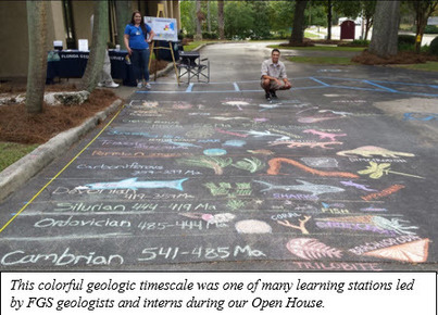
In celebration of the 19th
annual Earth Science Week, the Florida Geological Survey (FGS) hosted two days
of events at its facility in Tallahassee. The theme
this year was “Our Shared Geoheritage,” as part of the American Geoscience’s
Institute’s (AGI) Earth Science Week Program. On Wednesday, Oct. 12,
the FGS opened its doors to the public, giving a glimpse into the FGS facility
and what it has to offer. A geologic timescale chalked on the front driveway
welcomed guests as they arrived, along with the mobile drill coring rig, a
fossil dig for children, educational brochures and friendly staff. Upon
entering the building, guests were greeted in the Walter Schmidt Museum of
Florida Geology, which features displays including a dugong skeleton and an extinct mako shark jaw. Indoor learning stations included an activity room where
younger guests could make fossil molds using sea shells and Play-Doh, examine rock and sediment samples
through microscopes and explore aquifer rocks, minerals and fossils. Guests of all ages enjoyed learning about sample processing
and working with 3D visualizations of geological data in the GIS lab.
The open house also included geoscience
displays and interactive talks including the "Power
of Limestone," "Florida’s
Amazing Fossils," "Sinkholes," and "Side Scan Sonar Data Collection." At times, the FGS building was at full capacity as scores of
people learned about Florida’s geology, leaving with a better understanding of
why the FGS mission is important to the state.
On Friday, Oct. 14,
the FGS hosted 26 students who came to learn about geology in Florida and what
geologists do. Educator packets were provided to teachers, courtesy of the AGI.
Over the course of the two-day Earth
Science Week event, nearly 300 people visited the facility.
Contact:
Sarah Erb, OMC Manager
Back to top
|
As one would expect, the
need for geoscience exists throughout nearly all areas of DEP. The FGS routinely supports these needs,
especially in DEP Regulatory Programs.
This article highlights a few examples from recent months.
STONE
CRABS AND GEOLOGY
The 2016 hurricane season was eventful in Florida. In the wake of Hurricane Hermine, coastal counties
in the path of the storm were visited by state officials, including Gov.
Scott, to assess the damage to local communities and to provide
assistance. Fishermen in Keaton Beach
who make their living harvesting stone crabs reported to state officials that
the navigation channel providing access to offshore harvesting grounds had
filled in with sediment, making it difficult for boats to navigate. With the
stone crab season rapidly approaching, the fishermen requested to have the
channel dredged to allow their boats to pass.
In response to this
request, the DEP Northeast District Office asked the FGS to assist them in
sampling the sand that had shoaled into the navigation channel and to perform sedimentological
analyses.
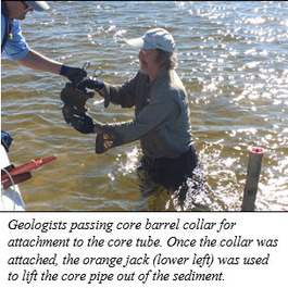
In mid-October, FGS staff
mobilized equipment and a boat to Keaton Beach and collected vibracores in the infilled
channel. Vibracoring is a technique for
collecting sand sediments in which a core tube connected to a vibrating source
is lowered into the sediment. Once back at the FGS lab, the cores were cut and
sediment samples were collected, dried, weighed and sieved, noting the material
passing through the sieve. These data allowed for informed decision making
to ensure compliance of all state and federal rules prior to any dredging.
|
BEACH SAND – THE RIGHT STUFF
Hurricane Matthew also caused substantial coastal erosion along Florida’s east coast. Numerous beaches were impacted, which negatively affected Florida’s economy. Restoration of impacted beaches requires reintroduction of sand that must be carefully matched to existing beach sediments, based upon a number of factors. For example, if the replacement sand is too fine, the sediment will erode rapidly. There are also habitat considerations that support the need for the sediments to meet certain criteria. Sand nourishment can be very costly, so every effort is made to find sand sources, both inland and offshore, that are suitable for placement on beaches.
The FGS was asked to assist the DEP Division of Water Resource Management with assessing the suitability of sand from a mine in northeastern Florida. Sand samples from the mine were processed at the FGS sedimentology lab in Tallahassee. The samples underwent granulometric, carbonate fraction, and color analyses. The results will help determine whether sand from this mine can be used for beach nourishment.
BIG MAPS – BIG DEAL
In the non-regulatory arena, FGS recently cooperated with the Division of State Lands in support of the Horn Spring property acquisition – a Florida Forever land purchase. FGS staff collected high resolution springs photographs, conducted new spring-flow measurements, provided an inventory of known springs, and created maps for presentation during a Cabinet Meeting in support of the 11,027-acre Horn Spring property purchase proposal, which was approved by the Governor and Cabinet. The purchase is the second largest land conservation purchase in Florida’s recent history.
Contact: Harley Means, P.G. Administrator
Contact:
Back to top
|
|
 |
The FGS STATEMAP
program
once again received funding from the U.S. Geological Survey (USGS) to support refined
geologic mapping of the USGS 30 x 60 minute St. Petersburg quadrangle. Field
work for the project began in September
2016 and will be completed in August 2017. The project will result in an
Open-File Map Series (OFMS) and Open-File Report (OFR), to be published
in late
2017. This mapping, which was funded in part by the STATEMAP component of the National
Cooperative Geologic Mapping Program (NCGMP), represents the 23rd
consecutive year that the FGS has received funding from the NCGMP for geologic
mapping in Florida.
The STATEMAP program also completed
mapping of the USGS 30 x 60 minute Jacksonville quadrangle in August 2016
(Figure 1, blue box). Field mapping crews from the STATEMAP program spent
several weeks in the area gathering new data for the map.
Additionally, the FGS Geological Data Acquisition Program drilled more than 900
feet of new cores for the project. Several hundred wells and surface samples archived
at the FGS Sample
Repository
were examined by staff geologists for geologic contact data and compiled
along
with field data and the new core data to generate the geologic map. The
project produced a new geologic map, a geomorphology map, geologic cross
sections (OFMS
108), and explanatory text (OFR 105). These maps and reports are available via the FGS website.
STATEMAP proposals, which are submitted each
November to the USGS for funding consideration, are based on recommendations for mapping priorities established by the State
Mapping Advisory Committee (SMAC). Each October, the SMAC meets to select the area which will be
proposed to the USGS for new mapping and to refine the three-five-year
geologic mapping plan. This mapping plan is based on the panel’s discussions
regarding the needs of Florida.
|
 |
This year, in
addition to making plans to map the Vero Beach and Fort Pierce quadrangles in
the next five years, the SMAC prioritized the Kissimmee and Fernandina Beach
quadrangles for proposal to the USGS STATEMAP program for 2017-2018. The SMAC unanimously agreed that these quadrangles were high priority
for new geologic mapping.
Geologic maps and
reports produced under the STATEMAP program are an important resource for local
planners and environmental managers as decisions are made about growth and
economic development, infrastructure improvements, groundwater protection, mineral
resources and other issues that affect the citizens of Florida. A recent study by Elisabeth
Häggquist, and Patrik Söderholm (2015) indicates that geologic mapping and
other types of geoscience information can far exceed a benefit-cost ratio of
30:1.
Contact: Rick Green, P.G.
Back to top
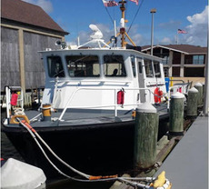
A surplused
U.S. Coast Guard (USCG) vessel was awarded to the FGS through the U.S. General
Services Adminstration. The vessel,
renamed “Research Vessel (R/V) GeoExplorer,” replaces the aging R/V GeoQuest. The 55-foot GeoExplorer will be used by
the FGS for collection of geological samples and geophysical data along Florida’s
continental shelf. These activities support
seafloor geological mapping to identify potential reserves of mineral sands for
beach restoration, among other applications.
Replacement of the GeoQuest by the GeoExplorer reduces maintenance and repair costs while
providing three times the range for geoscience missions, twice the number of
berths and improves crew safety. Operational
and maintenance expenses of the GeoExplorer are revenue-neutral through
contracts and interagency agreements.
The
GeoExplorer’s beam overall is 16’10”. The vessel has a cargo capacity of
4,000 pounds, and a range of 900 nautical miles. It can transit seas up to six
feet, handle winds up to 30 knots and is powered by two 12-cylinder diesel
engines that have a rated horsepower of 540 at 2300 RPM. The fuel capacity at
95 percent is 855 gallons. The
crane formerly used by the USCG to hoist and secure buoys
and
aids to navigation is fixed to the vessel. The crane will now be
instrumental in sea-floor sample collection via cores and grab samples.
|
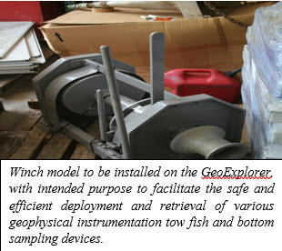 The
vessel’s main cabin has three access doors that open to the deck. The
below-deck berths, the “head,” the workroom and the engine room can be
accessed from the main cabin and the deck. A crane and an auxiliary
piloting station and two deck winches are on the back deck. Also located
on the back deck are equipment storage boxes and deck-mounted
stanchions, which can be removed for better access to the deck. The
berthing compartment contains bunks for four people, lights and storage
lockers. A toilet, sink and shower are located on the vessel.
Acquisition
of the R/V GeoExplorer allows the FGS to operate safer, more
efficiently and under a broader range of sea conditions. It also
improves our ability to conduct data gathering missions that support FGS
goals while collaborating with other agencies to address state
priorities related to coastal zone habitats and resources.
Contact: Dan Phelps, P.G.
Back to top
|
|


