|
Welcome to the June 2024 edition of the Florida Geological Survey (FGS) News and Research. The FGS achieved several important research milestones since our last edition. In this issue, read about our successful completion of a project focused on geologic mapping and characterizing heavy mineral deposits. Heavy minerals are economically valuable resources, supporting the manufacture of technology essential for communications and defense. We were also recently awarded funding from the United States Geological Survey (USGS) to complete two large projects. With these funds, the FGS will digitize geophysical logs from historic oil and gas wells, making them publicly available and improving ease of access. Additionally, the FGS will produce surficial geologic maps and refine data showing the distribution of quartz sand deposits. These products provide information about resources that could be used in the aftermath of natural disasters, such as hurricanes. We are excited to begin these new projects, which can increase Florida’s resilience and access to important geologic information.
This February, the FGS hosted the second workshop for the East Gulf Coastal Plain Stratigraphic Reconciliation Initiative Working Group, during which we collaborated with geoscientists in neighboring states. Together we refined our understanding of how our shared lithologic units are related. In addition to holding workshops, our staff refreshed and enhanced their knowledge of Florida geology by visiting important exposures. In March and April, FGS geologists travelled to Citrus County and parts of northwest Florida to examine the Avon Park Formation, as well as the much more recently deposited Quaternary undifferentiated sediments and the divided Quaternary units, described in this newsletter.
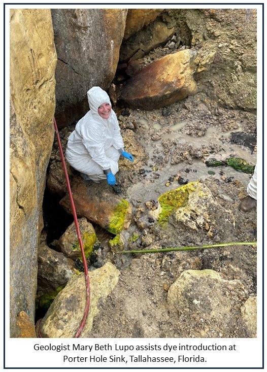
We are frequently asked to speak about how groundwater and surface water are connected. In Tracer Series, Part III: Why Florida Needs a Tracer Database, we describe the need to collect, preserve and make searchable data generated from traces. If we can systematically consolidate and share information from past investigations, these data can retain their value and continue to inform current and future research. To promote the accurate sharing of information, we have also made some changes to our newsletter. Recurring series, such as the GEOFACT and Featured Formation series, contain succinct, current articles about Florida-specific geological topics. To help users refer to these articles, we will now be including a suggested citation at the end of our more science-focused articles.
Finally, on April 11, 2024, Director of the Division of Recreation and Parks Chuck Hatcher and Park Manager Kevin Patton welcomed us to Paynes Prairie Preserve State Park, which I was pleased to designate as our eighth State Geological Site. We will highlight our State Geological Sites in a newly created display during our annual Open House this October. We hope to see you there. Stay tuned for an announcement to be released late this summer.
As always, thank you for your continued support of our organization.
Sincerely,
Guy H. Means
Director and State Geologist
Florida Geological Survey
Florida Department of Environmental Protection

 |

In our last two issues, we introduced the first and second parts of our three-part series on tracing, a collection of methods that allows scientists to trace where water or fluid goes. Part I, which focused on dye tracing, provided an overview of Florida’s hydrologic environment and why tracing is essential. Part II of this series focused on non-dye tracing techniques, which include chemical and biological tracing. For our third and final installment, we introduce the idea of a tracer database, present what a database could look like, provide a discussion of what this database would support and why Florida needs one.
In review, tracing surface water and groundwater flow paths helps us understand the hydrologic complexities in Florida’s rivers and aquifers. Tracing studies show us where the water goes, how fast it gets there, how much of it goes in that direction and if it mixes with other water sources or contaminants along its path. Hydrogeologists, hydrologists and engineers use that information to apply qualitative and numerical properties to the surface water and groundwater flow characteristics specific to those rivers and aquifers from which flow models can be made to forecast how those resources change over time. These flow models can then inform transport models that predict the movement and mixing of non-drinking water resources, such as saltwater or pollutants, with drinking water resources. The knowledge gleaned from tracing studies enables scientists, stakeholders and resource managers to develop a more comprehensive understanding of the hydrologic system and its geologic framework allowing for better environmental stewardship of our critical surface water and groundwater resources.
A tracer database could take on a variety of forms. States like Minnesota, Missouri and Kentucky already have tracer databases that are accessible to the public and are served as data downloads and/or on interactive platforms. Some states, like Missouri, require tracing studies to be legally registered and recorded within their tracer databases. A tracer database doesn’t have to involve permitting or other government regulated actions. Submissions can come in the form of a notice being filed that provides the details of the trace and includes site specific information regarding the introduction or injection site, monitoring and sample sites. We ask that researchers include the following information:
- Sampling and analysis methods and laboratory(s);
- Tracer type(s), such as
- Dye,
- Chemical, and
- Biochemical analytes;
- Tracer volume and concentration;
- Tracer chase water volumes;
- Stream discharges at the introduction and detection sites;
- Dates of introduction and sampling; and
- Pertinent detection/analytical results.
The FGS has established a beta version of a tracer database that captures this information from our own traces and includes data from traces conducted by others that have been shared with us or have been gleaned from publicly available reports. In the future, the FGS is planning for its tracer database to be publicly served through an interactive online mapping interface.
Tracer studies are conducted more often than most people realize. Local, state and federal agencies as well as private consultants conduct tracer studies for private interest groups and businesses, while others are conducted by universities and environmental organizations. The purpose of each trace may vary, and most are designed to resolve a specific issue at hand; however, the data, if not collected and maintained, can be lost or otherwise made unavailable. Maintaining a record of traces conducted in Florida helps ensure the integrity of each study conducted and informs new and repeated ones. For instance, if two groups are planning concurrent traces in the same basin, and plan on using the same tracing analytes, the results of both traces may be called into question, therefore invalidating the results. Reporting traces and making the data publicly available would serve as a resource for all stakeholders and research groups working in an area and would protect against the possibility of cross contamination and redundancy of traces.
For more information or to submit your data to our FGS tracer database please contact: Mary E. Lupo, Ph.D., P.G. and Clint Kromhout, P.G.
Suggested Citation:
Lupo, M.E., and Kromhout, C.K., 2024, Tracer Series, Part III: Why Florida Needs a Tracer Database: FGS News and Research June 2024 edition. https://content.govdelivery.com/accounts/FLDEP/bulletins/39fb562.
|
Back to top
|
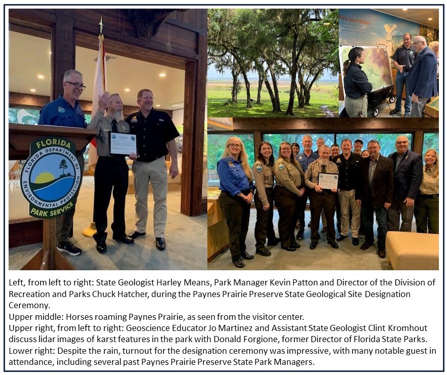
On April 11, 2024, State Geologist and Director of the Florida Geological Survey Guy “Harley” Means designated Paynes Prairie Preserve State Park a State Geological Site. A ceremony was held in the preserve’s newly renovated visitor center. More than 40 citizens, park staff and invited guests gathered for the event. Director of the Division of Recreation and Parks Chuck Hatcher and Park Manager Kevin Patton provided opening comments about the history and importance of the park prior to Means’ designation speech. State Geological Sites are designated, pursuant to Section 377.075 (4)€, Florida Statutes, by the State Geologist if they are determined to be of great and continuing significance to the scientific study and public understanding of the geological history of this state. Means discussed the geological, hydrological and cultural importance of Paynes Prairie Preserve State Park, along with its conservation and ecological value. For these reasons, Paynes Prairie Preserve State Park was designated as one of eight State Geological Sites in Florida.
|
 |
The Geology of Paynes Prairie Preserve State Geological Site
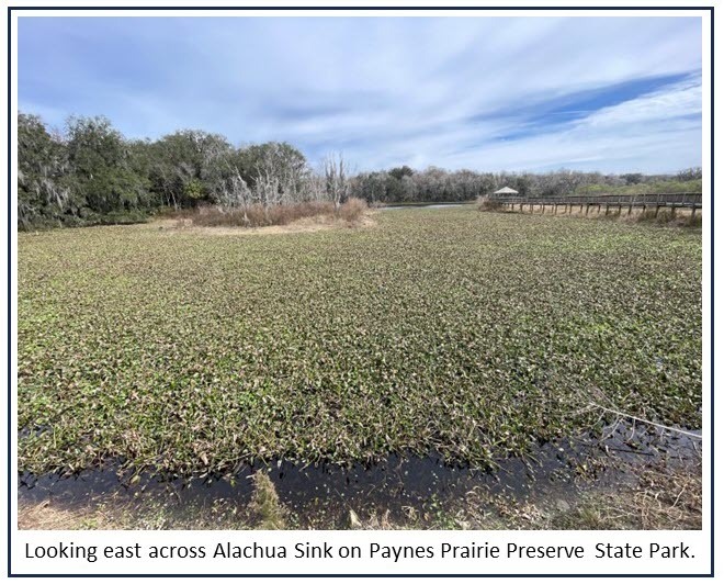
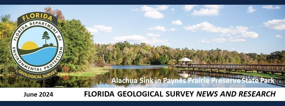
Paynes Prairie Preserve State Park, located in Alachua County between Gainesville and Micanopy, is a 23,000-acre park that contains spectacular examples of karst features in Florida. Landforms that are created as limestone slowly dissolves over geologic time are called karst features and include things like sinkholes, caves, springs and sinkhole lakes. Paynes Prairie is a karst feature called a polje, which is a Croatian word for a large, flat bottomed, steep walled depression created by the coalescing of multiple sinkholes. Since Paynes Prairie is a topographic low spot, called a basin, it can hold water when rainfall is plentiful. However, during drought conditions, the water level in the basin drops as some of it drains into the underlying aquifer, through Alachua Sink, and some water is removed through the process of evapotranspiration. When the amount of water leaving the basin is greater than the amount coming in, water levels decline across Paynes Prairie.
|
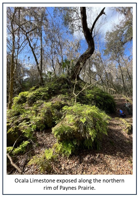
Paynes Prairie Preserve State Park is underlain by the Ocala Limestone, which is a marine limestone formation that was deposited across most of Florida about 35 million years ago. At that time, Florida was submerged and the remains of countless fossil marine organisms accumulated on the sea floor. Over millions of years, these fossils became compressed and cemented together to form the Ocala Limestone. The Ocala Limestone is exposed along the steep sides of Paynes Prairie and in the many sinkholes that occur throughout the park. There is also a “pinnacle” of Ocala Limestone that sticks up just east of Alachua Sink. The pinnacle is an erosional remnant that was less susceptible to the processes of erosion than the surrounding limestone.
Undifferentiated formations of the Hawthorn Group, comprised of clay and clayey sand, overlie the Ocala Limestone in the higher elevation areas within the park. The clay content of the Hawthorn Group sediment provides enough cohesive strength to facilitate the development of cover-collapse sinkholes where it is present. Cover-collapse sinkholes are typically larger and deeper than other types of sinkholes and create a dramatic landscape where they occur. Along the northern rim of the prairie is an excellent place to observe these kinds of sinkholes.
In parts of the park, the Ocala Limestone is silicified, meaning the limestone has been replaced by silica. This material is also called chert. In Florida, silica weathers out of the overlying Hawthorn Group clay and, over time, can become concentrated by groundwater. Silica can then replace the original mineral in the limestone. Chert is much harder than limestone and was used by prehistoric Native Americans to make tools like scrapers, spear points and adzes. Examples of these tools have been discovered at sites within Paynes Prairie Preserve State Park and show that prehistoric Floridians were adept at locating and utilizing geologic resources like chert. Should you encounter prehistoric artifacts within a state park it is best to leave them undisturbed and report them to a park official.
Contact: Harley Means, P.G.
|
Back to top
This article is the first in a multi-part series discussing Quaternary undifferentiated sediments in Florida. The general character of Quaternary undifferentiated sediments and the divided Holocene sediments are the focus for this edition.
Many areas in Florida have quartz sand and other sediments at the land surface and are not underlain by a formally named geologic unit within the upper 20 feet from the land surface. There may only be rough estimates of the age of these geologic deposits, and they may not have a distinct, consistent lithology that defines them statewide. Starting with the publication of the Geologic Map of the State of Florida (Scott et al., 2001), these units were geologically mapped as Quaternary undifferentiated sediments (Qu), presuming that geologists could reasonably ascertain that they are from the Pleistocene or Holocene. Because Qu sediments thinly blanket much of the state, and in keeping with geologic mapping practices developed by Scott et al. (2001), the FGS adopted the procedure of mapping the first named geologic unit within 20 feet of the surface. If Qu material has a thickness greater than 20 feet, it appears as the mapped unit. If Qu is less than 20 feet thick, the underlying lithostratigraphic unit appears on the map.
To promote a better understanding of Florida’s surficial geology in the 2001 map and onward, due to how much of this Qu material is at the land surface in Florida, the FGS has attempted to divide parts of the Qu into separate units to assist the user’s understanding of Florida’s geologic history. The Quaternary undifferentiated units are based largely upon geomorphologic characteristics and include Holocene sediments (Qh), Quaternary beach ridge and dune (Qbd), Quaternary alluvium (Qal) and Trail Ridge sands (Qtr).
In cases where none of the geomorphically divided units of presumed Quaternary age are mapped at the land surface or in the shallow subsurface, these deposits are referred to as Qu. The following quote from Scott (2001) describes the very broad and diverse lithology of the Qu for geologic mapping in Florida.
The siliciclastics are light gray, tan, brown to black, unconsolidated to poorly consolidated, clean to clayey, silty, unfossiliferous, variably organic-bearing sands to blue green to olive green, poorly to moderately consolidated, sandy, silty clays. Gravel is occasionally present in the panhandle. Organics occur as plant debris, roots, disseminated organic matrix and beds of peat. Freshwater carbonates, often referred to as marls in the literature, are scattered over much of the State. In southern Florida, freshwater carbonates are nearly ubiquitous in the Everglades. These sediments are buff colored to tan, unconsolidated to poorly consolidated, fossiliferous carbonate muds. Sand, silt and clay may be present in limited quantities. These carbonates often contain organics. The dominant fossils in the freshwater carbonates are mollusks (p. 23).
The Holocene Epoch represents approximately the last 12,000 years of Earth's history. During that time, sea level has risen dramatically. Geologists at the FGS map areas as Qh because deposition occurred during the Holocene Epoch. Several lines of evidence are used to support a Holocene age interpretation. Some of the reasons, and some of the challenges, are described below. Overall, Qh sediment ranges from quartz sand, silt and clay to carbonate mud and sand, organics or even peat deposits. Shell material may also be present.
Many of the modern barrier islands and spits, where not underlain by a formally named geologic unit within the upper 20 feet from the land surface, are mapped as Qh. High accuracy lidar elevation data has significantly improved the ability to recognize very young coastal depositional landforms. Holocene coastal landforms like barrier islands, spits and linear dunes or shoreline deposits have distinct, clear edges. Weathering, sediment compaction and dissolution of shell material, among other factors, have not yet dulled the definition of these landforms.
 |
Deposits in regions adjacent to lagoons and estuaries, including in salt marshes and mangrove forests, may also be mapped as Qh. In these depositional environments, landforms do not often have a wide range of elevation change and are, therefore, less distinctive on lidar-based digital elevation models (DEMs). These deposits are assumed to be Holocene based on their relative location and elevation within the modern coastal depositional system.
River valleys and large lakes with extensive wetlands present contrasting depositional settings to the coastal and estuarine systems and more difficulties with respect to proper geomorphic interpretation. Some FGS geologists map the lower extent of river valley floodplains where they approach and meet an estuary as Qh. In other cases, these have been mapped as Qal. Sometimes Qh has been mapped in wetlands adjacent to inland river valleys like the St. Johns. However, other parts of the St. Johns River valley have distinct fluvial floodplain landforms, yet they are mapped as Qh rather than Qal. Lastly, several large lakes have Qh mapped in the wetland regions adjacent to the lakeshore. Interpretation and consistency are important considerations. Without detailed geomorphic and geologic mapping and age-dating of these deposits, it can be difficult to determine the parts of river valleys or lake basins that are filled with Holocene sediments.
The Holocene sediments of Florida are complex. Consistent hierarchical rules for interpretation of the Qh and other divided Quaternary undifferentiated units are essential to improving the FGS’s geologic mapping in areas where the Quaternary undifferentiated sediments and the divided Quaternary undifferentiated units occur.
This article provides a glimpse into our efforts to better understand and map Florida’s young, complex, Quaternary geology. In the next edition of this multi-part series, the Quaternary beach ridge and dune will be discussed.
Recently, the FGS and the USGS entered into a multi-year cooperative agreement for the FGS to map the distribution of the state’s surficial quartz sand deposits and conduct geologic mapping in parts of the Florida Panhandle. This research provides an opportunity to assess the FGS’s geologic mapping of the Quaternary undifferentiated sediments.
References Cited
Scott, T.M., 2001, Text to accompany the geologic map of Florida: Florida Geological Survey Open-file Report 80, 29 p., https://doi.org/10.35256/OFR80.
Scott, T.M., Campbell, K.M., Rupert, F.R., Arthur, J.D., Green, R.C., Means, G.H., Missimer, T.M., Lloyd, J.M., Yon, J.W., and Duncan, J.G., 2001, Geologic map of the state of Florida: Florida Geological Survey Map Series 146, scale 1:750,000, 1 sheet. https://doi.org/10.35256/MS146.
Contact: Christopher Williams, Ph.D., P.G.
Suggested Citation:
Williams, C.P., 2024, Featured Formation: Quaternary Undifferentiated Sediments and Divided Quaternary Undifferentiated Units in Florida, Part I: FGS News and Research June 2024 edition. https://content.govdelivery.com/accounts/FLDEP/bulletins/39fb562.
 The Geological Survey of Alabama received funding from the USGS to coordinate the East Gulf Coastal Plain Stratigraphic Reconciliation Initiative Working Group, comprised of representatives from the geological surveys of Alabama, Mississippi and Florida. The goals of this working group are to promote dialog regarding the stratigraphic nomenclature used by each state and identify issues related to correlating lithostratigraphic units across state lines. Developing consistent regional stratigraphic nomenclature will advance the USGS’s National Map goals and many other local, state and national projects that rely on an understanding of the geology across the Gulf Coastal Plain.
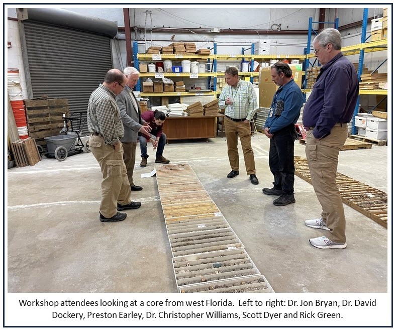
To facilitate discussions between states, two workshops were held. The first workshop was held at the Geological Survey of Alabama in Tuscaloosa. The second workshop was held recently at the FGS. It was attended by Mississippi State Geologist Dr. David Dockery and multiple staff from the Geological Survey of Alabama, including Dr. Sandy Ebersole, the principal investigator for the project. Seven FGS staff attended, including Dr. Jon Bryan, the project lead for Florida. Representatives from the Northwest Florida Water Management District, USGS and other FGS staff geologists attended the workshop virtually.
The second workshop kicked off with an all-day meeting, in which participants provided an overview of the progress made in correlating the stratigraphy across the three states. During lunch, attendees looked at two cores from the Florida Panhandle and discussed how the formations in the cores correlate to formations in eastern Alabama. Day two included a half-day meeting to identify remaining and future tasks. The meeting closed with an optional field trip to Jackson Bluff, an important geologic exposure and the type section of the Pliocene Jackson Bluff Formation. The workshop successfully stimulated constructive dialog regarding the geology of the eastern Gulf Coastal Plain. Project deliverables will be available in the coming months.
Contact: Harley Means, P.G.
Back to top
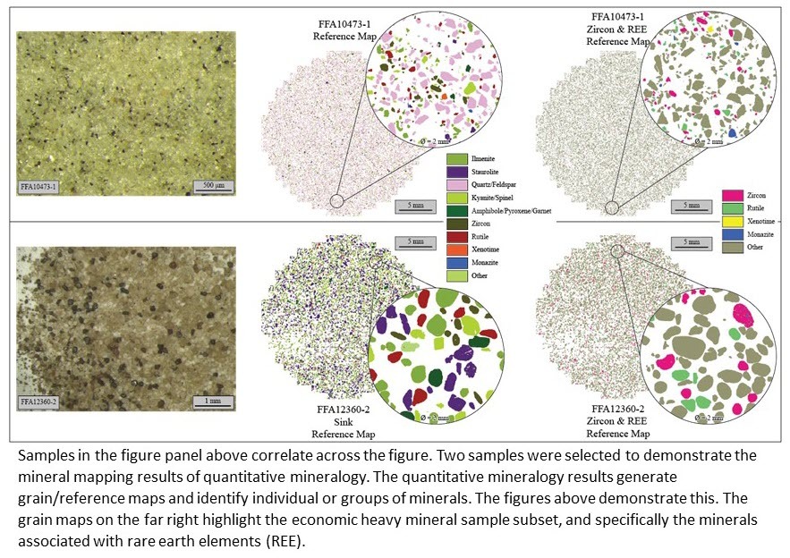
The FGS successfully completed a cooperatively funded project and submitted the contracted deliverables to the USGS in December of 2023. The deliverables include a project report, a surficial geologic map, cross sections, geomorphic map and accompanying descriptions from FGS SP-59 and a high-resolution digital elevation model for the study area constructed using the most recently available lidar. The report presents a discussion of the geology, characterization of each geologic unit encountered at the land surface and in borehole samples, subsurface structures affecting the geology of the region, methods for collecting and analyzing samples, and data tables for quantitative mineralogy and geochemical analyses of heavy mineral sand samples collected along and adjacent to Trail Ridge.
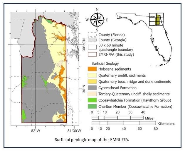 |
The study, informally referred to as the Earth Mapping Resources Initiative, Florida Focus Area (EMRI-FFA), encompasses a large area of roughly 2,500 square miles, spanning across portions of six USGS 1:100,000 quadrangles: Fernandina Beach, Okefenokee Swamp, Jacksonville, Lake City, Saint Augustine and Gainesville. New surficial geologic mapping completed for this project will facilitate ongoing mapping efforts in three neighboring USGS 1:100,000 quadrangles (Fernandina Beach, Okefenokee Swamp and Lake City) to be incorporated into a new statewide surficial geologic map of Florida.
The mineral analyses of heavy mineral sands include quantitative mineralogy and grain size, elemental and major oxide concentrations and uranium-lead (U-Pb) geochronology. The uranium-lead (U-Pb) geochronology results are still forthcoming from the USGS and, once received, will be integrated into the report and published as FGS Report of Investigation 123 (2024). These results build on our current understanding of Florida’s heavy mineral sand deposits and provide additional characterization of the heavy minerals present along Trail Ridge and adjacent areas in northeast Florida.
 Contact: Mary E. Lupo, Ph.D., P.G.
Back to top
|