|
Hello, and welcome to the October 2023 Florida Geological Survey (FGS) News and Research edition.
It is hard to believe everything we have accomplished in the past few months. Our employees have made tremendous progress with ongoing research projects while still finding time to provide our customers with presentations and outreach events, including the annual Tallahassee Science Festival, where 365 members of the public visited the FGS booth. The most recent dry-down event at Lake Jackson in Tallahassee allowed me to discuss our unique karst landscape in an interview for WTXL ABC 27 local news. In a massive group effort spearheaded by FGS employee Dr. Mabry Gaboardi Calhoun, the renovation of the Walter Schmidt Museum came to fruition in time for our annual Earth Science Week open house, which you can read about in this issue.
I am proud of our geoscience professionals and the essential work they do. Last month, the FGS was featured in a USGS National News Release about our participation in support of locating critical minerals and hurricane resiliency through new federal-state mapping efforts. Our work was further highlighted in a brief video production that premiered at the Geological Society of America’s (GSA) annual meeting in Pittsburgh. It is part of the ConnectsCast series, which features multiple state geological surveys and academic departments. The Association of American State Geologists (AASG) has a long history with GSA and the FGS. Learn more about AASG and FGS’ role in the organization in this issue.
In May, we introduced a three-part series on tracers with an overview of dye tracing. Today, I invite you to read the second edition of the series, which discusses non-dye tracers. Read on to learn about the lithostratigraphy of the Arcadia Formation and how this complex geologic unit fits into Florida’s stratigraphic framework. Florida’s award-winning state parks are great places to see Florida’s unique geology, and Wes Skiles Peacock Springs State Park, with more than six miles of submerged cave systems, epitomizes the natural beauty of our state both above and below the land surface.
Last but certainly not least, we are thrilled to welcome guest author Dr. Jonathan R. Bryan, P.G., a professor of geology and oceanography at Northwest Florida State College. Dr. Bryan discusses the FGS’ contribution to the Florida Museum of Natural History’s microfossil collection and provides an overview of micropaleontology.
As always, thank you for your continued support of our organization.
Sincerely,

Guy H. Means
Director and State Geologist
Florida Geological Survey
Florida Department of Environmental Protection


In our last issue, we introduced the first part of our three-part series on tracing, a collection of methods that allows scientists to trace where water or fluid goes. Part one, which focused on dye tracing, provided an overview of Florida’s hydrologic environment and why tracing is essential. Part two of this series focuses on non-dye tracing techniques, which include chemical and biological tracing.
Humans are naturally curious creatures, constantly observing and wondering about their natural environment. Our observational skills enable us to decipher complex relationships, such as the locations of fresh, brackish, and saltwater and the mixing that may occur between them. Locating and tracking boundaries between these water types is important to our survival. People also seek to improve the world through science and engineering innovations like artificial, low-calorie sweeteners for our drinks, medicine for our headaches, rubber for tires, and rocket fuel to take us into space.
Unique chemical compounds resulting from scientific innovations can have unintended costs as they are introduced into the environment, potentially contaminating our air, soil, rock, and water resources. Fortunately, their unique chemical and biological characteristics can also make these compounds effective tracers, allowing scientists to trace where they go and how they interact with the environment. Artificially produced foods and sweeteners, like saccharin and sucralose, and common pharmaceuticals like caffeine, ibuprofen, and acetaminophen are readily traceable in surface water and groundwater due to their unique chemical signatures. Chemical compounds developed for industrial, agricultural, commercial, and residential practices are also readily traceable.
Some contaminants degrade into byproducts, or co-contaminants, whose ratios and associations can fingerprint possible sources and provide insight into when they were released. Examples include petroleum products like gasoline, diesel, kerosene, oils and lubricants, solvents used for cleaning or as chemical additives, or products used for crops, landscaping, and pest control like herbicides, insecticides, and fungicides. To understand how scientists use these compounds as effective tracers, let’s review different chemical tracer types, their applications, and highlight some examples.
Chemical Ions
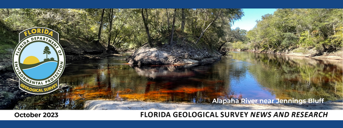
Chemical ions (atoms or molecules with an electric charge) and their properties are common tracers used to survey, map, and monitor environmental conditions. Much like dye, chemical characteristics provide a unique marker, or fingerprint, that can be used to study the physical and chemical interactions between water and rock. Natural surface water and groundwater possess expected concentration ranges of chemical ions based on the surrounding geology and environmental conditions. These conditions may include drainage, climate, and temperature. Deviations from these expected ranges allow scientists to use chemical ions as tracers. (Chemical compounds, atoms of two or more elements, can be used similarly. We discuss chemical compounds later in this article).
For example, let’s use chloride, Cl-, the base ion in table salt. Chloride is a standard parameter measured in water testing. Freshwater in a stream or lake has a low chloride concentration compared to saltwater. Similarly, freshwater from a potable aquifer, such as the Upper Floridan aquifer, has a low chloride concentration relative to water in a non-potable saline aquifer. Increases or decreases in chloride concentrations are traceable. In Florida, decreasing chloride concentrations along the coast may suggest the presence of a nearby freshwater spring. Seawater has an average chloride concentration of about 35,000 parts per million (ppm), while freshwater typically has less than 1,000 ppm. Knowing this information allows a scientist to trace chloride concentrations along a coastline and potentially locate where a freshwater spring is suspected to exist, as chloride concentration values will decrease.
Isotopes
Isotopes are another reliable tracer and are widely used for tracer investigations. Before we discuss the tracer capabilities of isotopes, let’s review some chemistry basics.
Each element on the periodic table has a different number of protons, neutrons, and electrons, making it unique. Isotopes of an element are defined by containing the same number of protons but varying numbers of neutrons in their nucleus. Therefore, the chemical properties of an element’s isotope are very similar, yet their physical properties are distinct. For example, an oxygen isotope containing eight protons and eight neutrons is known as oxygen-16 or 16O. An oxygen isotope containing eight protons and ten neutrons is oxygen-18 or 18O. These two oxygen isotopes are stable, meaning that they do not emit energy in the form of radiation. Alternatively, unstable isotopes, or radioisotopes, emit energy as ionizing radiation in a process known as radioactive decay.
The stable and radioactive properties of isotopes allow geoscientists to use them as natural tracers. Common stable isotopes used in groundwater studies include oxygen (16O and 18O), hydrogen (2H, or deuterium), sulfur (32S and 34S), and krypton (81Kr). Radioactive, or unstable, isotopes commonly used include hydrogen (3H, tritium), carbon (14C), and strontium (the ratio of 87Sr to 86Sr). For the scope of this article, we only discuss stable isotopes, but if you wish to read more about radioisotopes, please see the weblinks provided at the end of this article.
In our oxygen example above, you may recall that changes in neutrons are chemical reactions that affect an isotope’s mass (known as fractionation). A lighter isotope, like 16O, has chemical bonds that are easier to break, meaning it is more reactive than a heavy isotope, like 18O. Variation in mass between 18O and 16O is tracked as a ratio of the gain or loss of the heavy (18O) relative to the light (16O) isotope and occurs in certain environmental conditions.
The ratio of 18O to 16O in groundwater is light, meaning there is less 18O. Conversely, the ratio of 18O to 16O in surface water is heavier, meaning there is more 18O relative to groundwater. A geologist can use these ratios to determine relative ages and sources of water under certain environmental conditions, like when younger surface water mixes with older groundwater. For instance, a spring discharging isotopically light groundwater (less 18O) relative to other nearby springs reveals that the springshed (where the spring sources its water) receives more young surface water than older groundwater.
So far, we have learned how analyzing chemical ion concentrations and isotopes provides necessary data for geologists to characterize and track the path of water as it travels through the aquifer. Now, revisit our original discussion of chemical compounds and examine how their unique chemical and biological characteristics make them effective tracers.
Chemical Compounds
As you will recall from above, a chemical compound is a substance comprised of molecules containing two or more elements. Table salt is an example of a chemical compound because it is comprised of the elements sodium and chlorine. Chemical compounds can sometimes have multiple stable isotopes because some isotopes fractionate in a measurable way and under specific environmental conditions. Comparing multiple isotopes in a single water sample can inform us about the sample’s original chemical composition and source environment. Fecal waste from humans and agricultural livestock contains unique nutrient and bacterial signatures, making them easy to differentiate from nutrients and bacteria produced through natural processes.
Let’s illustrate this point by using nitrate, NO3, which contains the stable isotopes 18O and 15N. Nitrogen enters our surface water and groundwater from natural and anthropogenic (human) sources like our atmosphere, synthetic fertilizer, manure from agricultural livestock, or septic systems. By comparing the ratios of 18O and 15N, researchers can determine the nitrogen source in a water sample.
Human beings are naturally observant and have the capacity to solve problems through innovation. Unfortunately, anthropogenic activities produce a multitude of biological and chemical contaminants that negatively impact our environment. Geologists can use chemical and biological tracing to mitigate these impacts and provide valuable information that helps resource managers set environmental regulations and policies to protect our surface water and groundwater.
With the knowledge we have gained in Part I and Part II of this tracer series, we encourage you to join us in April 2024 for Part III, which will present the concept of a tracer database and how it could benefit Florida.
Contact: Clint Kromhout, P.G. & Mary Beth Lupo
For More Information:
Digaletos, M., Ptacek, C.J., Thomas, J., and Liu, Y., 2023, Chemical and biological tracers to identify source and transport pathways of septic system contamination to streams in areas with low permeability soils: Science of the Total Environment, v. 161866, p. 1-13, doi: http://dx.doi.org/10.1016/j.scitotenv.2023.161866
Poucher, S., and Copeland, R., (compilers), 2006, Speleological and Karst Glossary of Florida and the Caribbean: Gainesville, University Press of Florida, 196 p.
Radioisotopes: https://www.iaea.org/topics/nuclear-science/isotopes/radioisotopes
Radiotracers: https://www.iaea.org/topics/radiotracers
Back to top
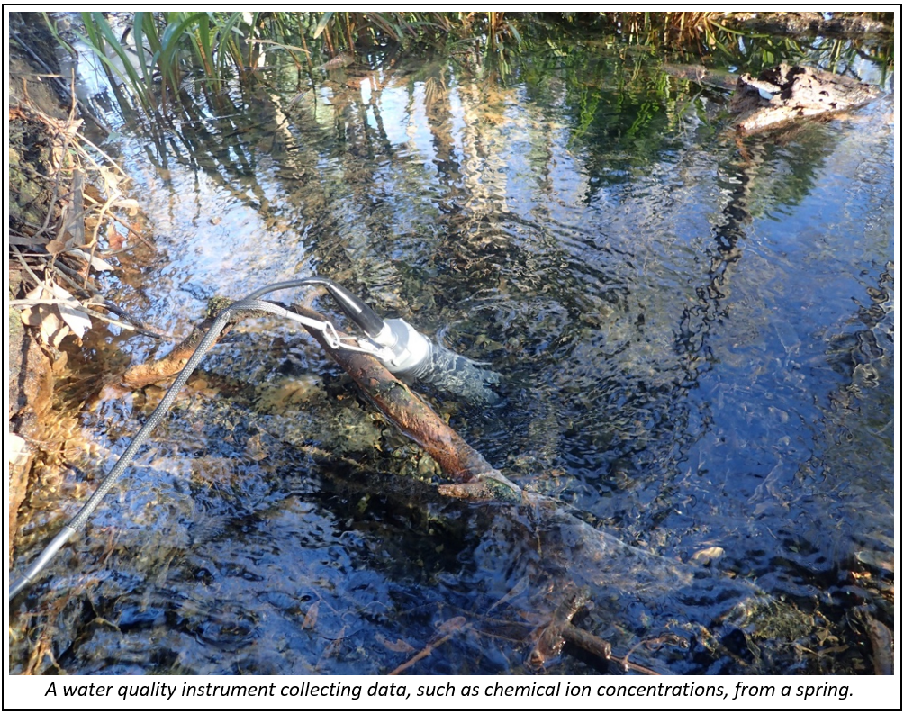
More than 250 customers visited the Florida Geological Survey (FGS) open house at FGS headquarters in Tallahassee on Wednesday, Oct. 11, to experience what the FGS does and how geoscience innovations help communities and accelerate environmental problem-solving. The open house was held during Earth Science Week (ESW), a national, annual event sponsored by the American Geosciences Institute (AGI). With only a few exceptions, the FGS has participated in ESW on a local level for the past 25 years.
The Florida Channel’s coverage of the open house captured the enthusiasm at the event and how even long-time open house visitors were pleasantly surprised by the newly renovated museum and the increase in interactive exhibits. Guests were among the first members of the public to view the renovated Walter Schmidt Museum of Florida Geology, featuring entirely new exhibits, including a replica of Waller’s terror bird, an interactive monitor used to explore Florida’s geomorphology, and a fulgurite collection, which included a large, mounted specimen created by lightening generated at the University of Florida’s Lightening Research Laboratory. Guests were allowed to touch real specimens, including a megalodon tooth, mastodon tooth cast, chert arrowhead, piece of Ocala Limestone, and numerous other fossils, rocks, and mineral specimens in designated touch trays. FGS geologists working at the event especially enjoyed it when children and adults brought rock and mineral specimens for identification. They explored their specimens more closely at the always-popular microscope station.
Younger guests enjoyed tactile experiences, including identifying animal fossils, coloring sheets featuring Florida’s prehistoric animals, reading books, and watching educational videos about how Florida formed and why FGS research is essential. Of particular interest for all ages were the paint-a-rock station, maps and puzzles of the U.S., and a new “investigation station” activity that allowed students to use hand tools and rock and mineral samples to explore the physical properties of Florida’s geologic materials. The physical properties of rocks became even more exciting (and messy) at the “weird rock properties” station, where geologists used oobleck, a suspension of cornstarch and water that behaves like a solid or liquid, depending on how much pressure you apply to it with your hands.
 |
The “innovations in visualizing Earth” station offered multiple opportunities for guests to learn about data collection and mapping technology. While some visitors used computer tablets to pick out their favorite geologic locations on a map and complete fun, interactive quizzes about Florida’s geologic sights, others were provided with demonstrations of current mapping projects using 3D mapping technology. Some guests shared that their favorite part of this station was viewing aerial imagery of a particular location over time and seeing how the landscape has changed.
Fan favorites from previous years were back by popular demand, including the FGS drill rigs, publications table, and “inside a deep well” stations. FGS was also proud to have a food truck and a booth from the North Florida Wildlife Center, where a docile, blue-tongued skink was available for petting and photographs.
Many DEP employees stopped by the open house, including DEP Secretary Shawn Hamilton and Chief of Staff Anna DeCerchio. In a message to DEP employees, Mr. Hamilton stated, “This kind of outreach helps the public understand and appreciate what we do, facilitates a culture of responsible environmental stewardship, and cultivates a new generation of environmentally informed and engaged Floridians.”
Contact: Sarah Erb & Mabry Gaboardi Calhoun
Back to top
Lithostratigraphy is the classification of rock layers (strata) based on their physical properties and relative stratigraphic position. When geologists apply these classifications, they formalize a geologic unit. The formalized units are often defined as “formations.” Multiple formations can be included together into a single “group.” A formation can also have distinctive formal units within it that are known as “members.”
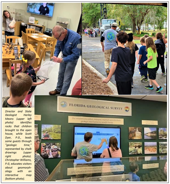
Part of a group of formations known as the Hawthorn Group, the Arcadia Formation was deposited between 33.1 to 16.7 million years ago during the early Oligocene to middle Miocene epochs. The Arcadia Formation contains two members and represents a distinct change in sedimentation on the Florida platform and within the Hawthorn Group. It is the lowest stratigraphic unit of the Hawthorn Group in southwest Florida. It sits unconformably atop older limestones such as the Suwannee (Oligocene) and Ocala Limestones (late Eocene) and is unconformably overlain by the Peace River Formation (middle Miocene to Pliocene).
Although the Arcadia Formation is mapped at the surface throughout the Tampa Bay area and, to a much smaller extent, along the Peace River, it occurs primarily as a subsurface unit. Because of the unit’s extent beneath the land surface, a type core (which provides subsurface samples) has been designated for the Arcadia Formation instead of a traditional type section (primarily surficial exposures). The type core for the Arcadia Formation is referenced in the Florida Geological Survey Sample Collections Facility as Hogan #1, W12050.
Geologists William Healey Dall and Gilbert D. Harris were the first to apply the term “Arcadia” when describing marl beds along the Peace River in 1892. In 1967, the term was used by Stanley R. Riggs to describe carbonate bed exposures in phosphate mines in central Florida. Finally, Tom Scott applied the name Arcadia Formation to the lower carbonate Hawthorn Group section in South Florida in 1988. Scott chose the name after the town of Arcadia and its proximity to the type core.
 |
The Arcadia Formation consists of dolostone and limestone containing variable amounts of quartz sand, clay, and phosphate grains. Dolostones are generally the most abundant carbonate component, ranging from yellowish gray to light olive gray. The limestones are white to yellowish gray and typically range from a wackestone to a mudstone with minor occurrences of packstone (limestone rock names referring to the abundance of mud and grains in the rock). Fossil molds can be observed in the carbonate rocks, which formed in shallow marine environments. Two formal members are recognized in the Arcadia Formation: the Tampa Member (carbonate dominant) and the Nocatee Member (siliciclastic dominant), as well as an informal unit referred to as the Venice Clay (siliciclastic dominant).
The aquifers in Florida are contained in various layers of rock. The Arcadia Formation hosts some of Florida’s aquifers, such as the Upper Floridan aquifer (UFA) and Intermediate Aquifer System (IAS). The Arcadia Formation generally comprises the most permeable parts of the IAS. The Nocatee Member usually correlates with the IAS. The Tampa Member is included in the UFA, where it is in contact with the Suwannee Limestone. However, there are locations where the Tampa Member is locally separated from the Suwannee Limestone and hydraulically disconnected from the UFA and is therefore considered part of the IAS.
Contact: Gary Fowler
For More Information:
Arthur, J.D., Fischler, C., Kromhout, C., Clayton, J.M., Kelley, G.M., Lee, R.A., Li, L., O'Sullivan, M., Green, R.C., and Werner, C.L., 2008, Hydrogeologic framework of the Southwest Florida Water Management District: Florida Geological Survey Bulletin 68, 102 p., 59 pl., https://doi.org/10.35256/B68.
Brewster-Wingard, G.L., Scott, T.M., Edwards, L.E., Weedman, S.D., and Simmons, K.R., 1997, Reinterpretation of the peninsular Florida Oligocene: an integrated stratigraphic approach: Sedimentary Geology, v. 108, p. 207-228.
Dall, W. H., and Harris, G. D., 1892, Correlation paper – Neocene. U.S, Geological Survey Bulletin, v. 84, p. 85 – 158.
Riggs, S. R., 1967, Phosphorite Stratigraphy, Sedimentation, and Petrology of the Noralyn Mine, Central Florida Phosphate District. University of Montana Ph.D. Dissertation.
Scott, T.M., 1988, The Lithostratigraphy of the Hawthorn Group (Miocene) of Florida: Florida Geological Survey Bulletin 59, 148 p., https://doi.org/10.35256/B59.
Westerhoff, W. E., and Weerts, H. J. T., 2013, Quaternary Stratigraphy | Lithostratigraphy, Encyclopedia of Quaternary Science, second edition.
 |
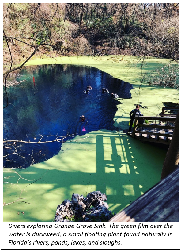
Wes Skiles Peacock Springs State Park is a 733-acre state park located on the Suwannee River’s eastern side in Suwannee County, just between Live Oak and Mayo, Florida. The wildness that epitomizes North Florida and its natural beauty is on full display. Originally named Peacock Springs State Park, the Nature Conservancy purchased the land in 1985, and the State acquired it in 1993. The park’s name was amended in 2011 to honor the late Wes Skiles for his documentary filmmaking, springs advocacy, and contributions to cave exploration. Through his efforts and those like him, places as beautiful as Wes Skiles Peacock Springs State Park are protected and preserved landmarks for all to enjoy and learn about Florida’s water resources.
Wes Skiles Peacock Springs (WSPS) State Park offers visitors opportunities like picnicking, bird watching, and hiking. The 1.2-mile trail traces a network of underground cave passages, guiding hikers to the surface expressions of karst features that characterize the geology hidden below. These features include two major springs, a spring run, and six sinkholes. The calm turquoise water invites swimmers, snorkelers, and divers to explore exposures of an ancient carbonate platform altered over time through continued deposition, compaction, lithification, and later, dissolution via a process known as chemical weathering, resulting in a fine display of a submerged karst landscape.
Florida boasts over 1,000 freshwater springs, categorized by “magnitudes,” or how much water they discharge. Wes Skiles Peacock Springs State Park’s two main springs, Peacock and Bonnet, are listed historically as second magnitude springs (FGS Bulletin 66), meaning they can discharge up to 100 cubic feet of water per second. The water issuing from these springs flows from the subsurface and onto land because of the artesian pressure in the underlying aquifer. Peacock and Bonnet springs vent into their respective pools, and each pool feeds a quarter-mile stretch of slough, or low-lying wetland area. Peacock Slough receives groundwater contributions from three spring vents (Peacock I, Peacock II, and Peacock III). During high water conditions, the slough takes on the characteristics of a shallow spring run, creating a stream of flowing spring water. Peacock Slough connects these spring-fed wetlands south of Peacock and Bonnet Springs and continues south for another 1.3 miles before entering the Suwannee River.
|
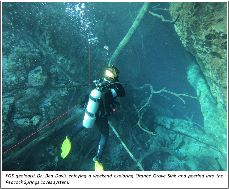
Guests can see groundwater exposed in other karst features along the trail and elsewhere within the park, including sinkholes and windows. These features provide a glimpse into the underlying aquifer where specific visual cues, such as clarity and algae, can indicate water quality. All of the features you see in the park are connected in some form or fashion, whether on a microscopic scale via interconnected pore spaces or on a megascopic scale such as caves and conduits. At WSPS State Park, some of the most spectacular geologic features are the megascopic karst features like the springs, sinks, windows, and their associated cave system. Orange Grove Sink (a karst window) and Peacock I Spring are the only two points that provide entry into the 6.25-mile submerged cave system. This cave system is comprised of an extensive network of passages and rooms. For a certified cave diver or technical diver, these passages allow exploration of what many consider Florida’s last “untouched” frontier. Divers provide scientists with critical information that enables us to understand local hydrogeology and the aquifer’s transmissivity, interconnectivity, and health.
The geology of the area surrounding the park is characterized by limestone either at or very near the land surface. The limestone visible in the park is the formally recognized Ocala Limestone, deposited between 37.8 and 33.9 million years ago as Florida was a developing carbonate platform. The framework that defines this lithostratigraphic unit and its ancient marine origins is best observed along trails where rocks are exposed at the surface or in the numerous submerged landscapes within the park. Where limestone is not exposed at the surface, it is overlain by a thin layer of younger, unconsolidated, and undifferentiated quartz sand and clay. With limestone very near the surface, this spatial relationship allows the slightly acidic rainwater to interact with the rock. This water-rock interaction slowly eats away the limestone, which increases the porosity and contributes to increasing karst development. Areas like this are essential because they allow the Floridan aquifer system to recharge or replenish its waters.
Wes Skiles Peacock Springs State Park provides a unique view into one of Florida’s geologic wonders and the opportunity to enjoy some of our most prized water resources. Whether you are an avid enthusiast or just looking to get outdoors, this park will surely give you an experience you’ll enjoy.
Contact: Mary Beth Lupo
For More Information:
Exploring groundwater pathways: Tracers Part 1 and 2.
Definitions and identification characteristics of springs: A Guide to Identifying Springs and Seeps in Florida.
FGS Springs webpage: https://floridadep.gov/fgs/fgs/content/springs.
Back to top
The Association of American State Geologists (AASG) includes state geological survey leaders in the United States and Puerto Rico, past leaders (honoraries), and other state survey staff (associates). Currently, 48 states have a geological survey (Hawaii and Georgia do not). The association’s goals include advancing the science and practical application of geology, improving state geological surveys’ effectiveness, evaluating the methods of acquiring and disseminating geologic data and information, and coordinating activities between state and federal agencies who work in geology and related fields.
The AASG held its founding meeting in Washington, D.C., on May 12, 1908. The meeting was hosted by the U.S. Geological Survey and was attended by 22 out of the 42 states with geological surveys. One of those in attendance was Dr. Elias H. Sellards, the first State Geologist of Florida. Since that founding meeting, Florida’s State Geologist, or a designee, has attended most of AASG’s annual meetings. Six of Florida’s state geologists have served on the AASG executive committee, and all have served the AASG in other roles, including chairing committees, being the editor of the State Geologists Journal, and hosting annual meetings (1952 and 2007). So far, five of Florida’s state geologists have served as AASG President: Herman Gunter (1953-1954), Robert Vernon (1967-1968), Bud Hendry (1986-1987), Walt Schmidt (1995-1996), and Jon Arthur (2014-2015).
I attended my first AASG annual meeting in 2022, with 29 other state geologists in Lake Tahoe, hosted by the Nevada Bureau of Mines and Geology. I met and interacted with my new colleagues throughout the meeting and learned more about each state survey. Representatives from federal agencies like the U.S. Geological Survey, National Oceanographic and Atmospheric Administration, Bureau of Ocean Energy Management, and other organizations like the American Geosciences Institute were also in attendance. Like FGS, many state surveys rely on funding from these agencies to conduct geologic mapping and mineral resource assessments. During the three-day meeting, I learned a great deal and returned home with a better understanding of the importance of the AASG.
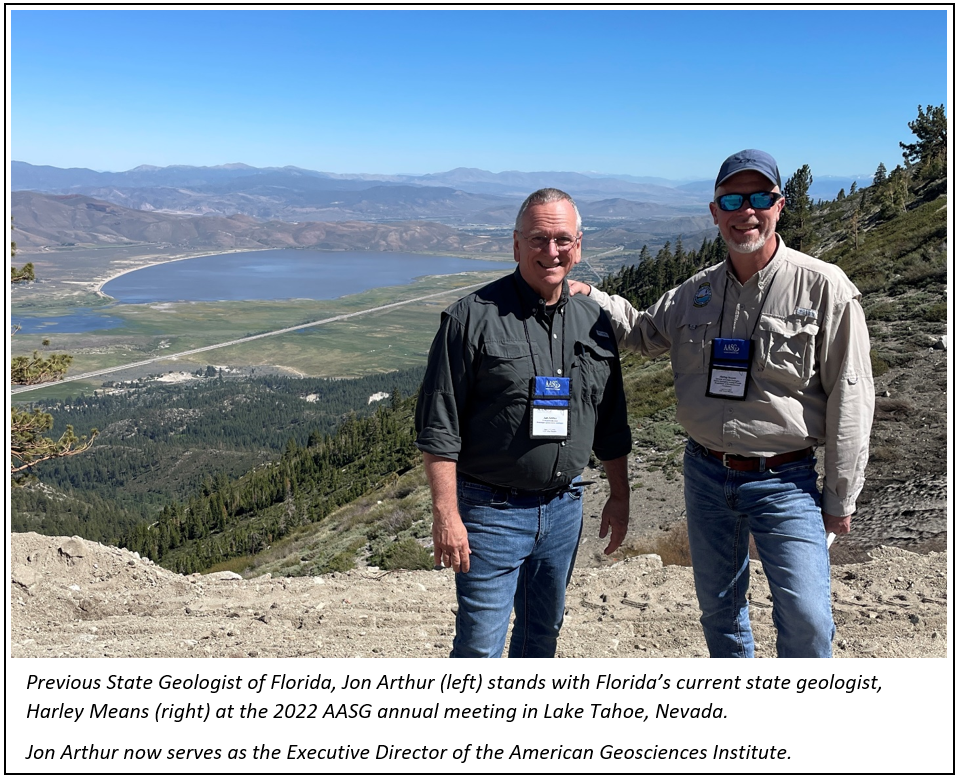
This past June, I attended my second annual meeting in Glenwood Springs, hosted by the Colorado Geological Survey. Thirty-five state geologists attended, seven of whom had been recently appointed. I recalled how I felt when I was new to my position at last year’s meeting, so I tried to speak to each of them about my experience and how helpful and supportive our AASG colleagues have been. During the meeting, I was elected Secretary of the AASG. I am honored to have been elected to the AASG Executive Committee and will proudly continue the long FGS tradition of participation and service in the association.
Contact: Harley Means
Back to top
|
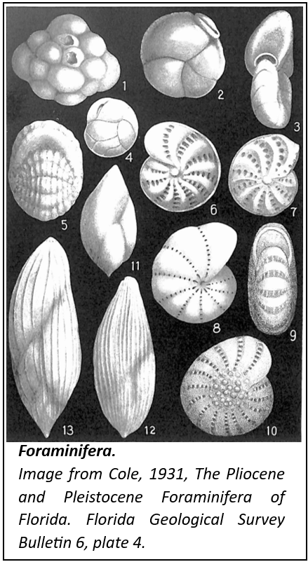
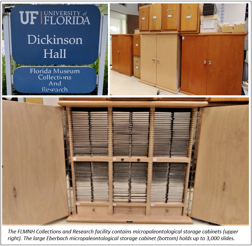
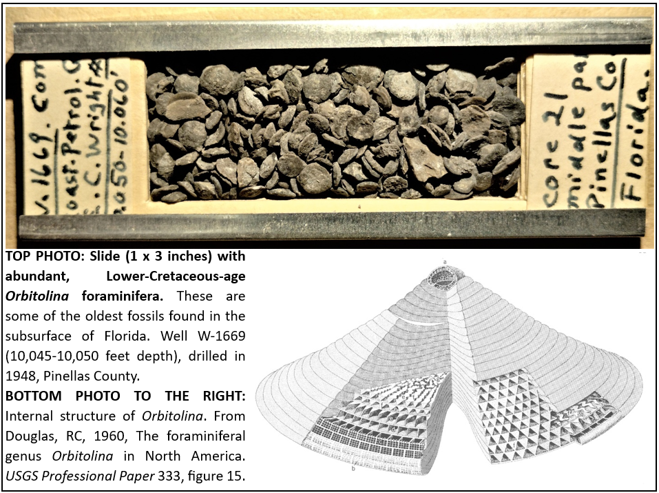
In recent years, the FGS has transferred some of its paleontological specimens to the Florida Museum of Natural History (FLMNH) to be curated and archived for additional research. In July 2023, the remaining FGS microfossil collection was moved to the FLMNH. Micropaleontology generally refers to the study of single-celled organisms in the fossil record with a tiny shell (called a test) composed of calcium carbonate or opaline silica. The most common microfossils represented in the FGS collection are foraminifera (“forams”). Sometimes called “shelled amoebae," forams are extremely diverse, and their tests can be beautifully ornate and complex.
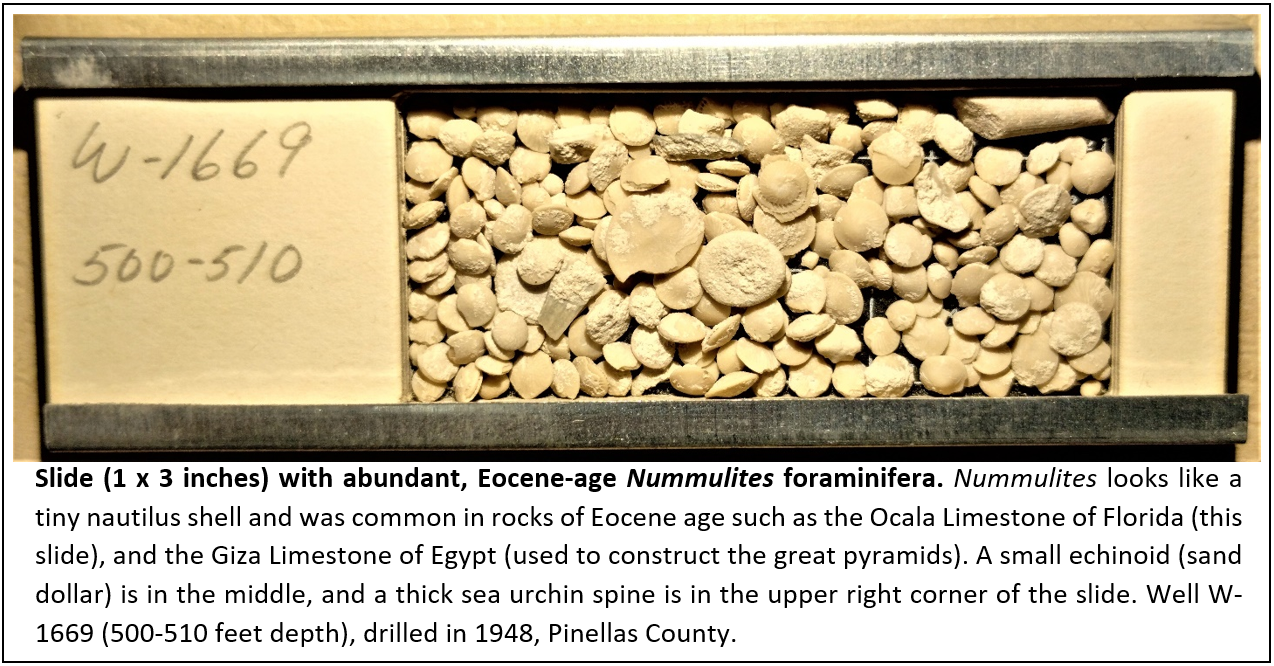
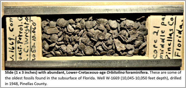
The FLMNH collection is primarily composed of Cretaceous, Paleogene, and Neogene foraminifera from Florida and the southeastern United States, with larger foraminifera (forams with tests up to a centimeter or more in diameter, and complex internal structure—see Nummulites and Orbitolina below) being especially well-represented. Metazoan (animal) taxa include an extensive collection of ostracods (small crustaceans with a bivalved shell), and bryozoa (colonial, “moss-animals”). The collection contains material that has been assembled over decades by many geologists and paleontologists, including Robert Vernon and Harbans Puri (FGS), Wayne Moore, Storrs Cole, Esther Applin, Louise Jordan, Lyman Toulmin (formerly at FSU), Alan Cheetham (U.S. National Museum of Natural History) and James Miller (U.S. Geological Survey). Specimens used in master’s and doctoral research are also in the collection.
|
In recent years, the FGS has transferred some of its paleontological specimens to the Florida Museum of Natural History (FLMNH) to be curated and archived for additional research. In July 2023, the remaining FGS microfossil collection was moved to the FLMNH. Micropaleontology generally refers to the study of single-celled organisms in the fossil record with a tiny shell (called a test) composed of calcium carbonate or opaline silica. The most common microfossils represented in the FGS collection are foraminifera (“forams”). Sometimes called “shelled amoebae,” forams are extremely diverse, and their tests can be beautifully ornate and complex.
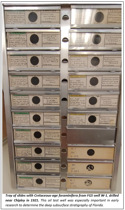
The FGS contribution to the FLMNH collection contains samples from hundreds of wells from across the state of Florida, and outcrop samples from important field localities. Figured and type specimens (used to describe new species) from early FGS publications (some published as early as 1930) comprise a large part of the collection. These early studies were foundational in the determination of the basic stratigraphic framework of Florida, especially in the deep subsurface. Another important part of the FGS material includes slides of lithologic samples of most subsurface rock formations of Florida, and a reference set of index or guide fossils from rocks of Pleistocene to Lower Cretaceous age, also of the Florida subsurface. These species allow geologists to quickly recognize the age of rock strata encountered in water wells, oil and gas wells, and rock cores which are routinely drilled in hydrogeologic applications, stratigraphic research, and in geological mapping.
|
|
|
The FLMNH Micropaleontology Collection is rapidly growing into an indispensable research archive of both paleobiologic and geologic significance. In terms of biodiversity, microfossils represent the most abundant, well-preserved, and complete record of past life. And unlike most other fossil groups, microfossils (especially foraminifera) are commonly found and easily collected from wells and cores that provide a near continuous sedimentological and paleontological record through geologic time. Geologically, this collection is of special value as a reference suite of biostratigraphically-important microfossils, extending deep into Cretaceous strata. The maintenance of this archive of subsurface microfossils is important for both academic and applied geologic research in the state of Florida.
Guest Writer:
Dr. Jonathan R. Bryan, P.G.
Professor of Geology & Oceanography
Northwest Florida State College
Back to top
|