|
Greetings! We have an exciting event coming up and hope you can attend! In the wake of Hurricane Michael, our Earth Science Week celebration was rescheduled. Please join us as we recognize this important event by attending the FGS Open House on Saturday, December 8. The theme of the event is “Earth as Inspiration.” In preparation, we look forward to reviewing inspired entries for the earth science Writing and Art Contests. Winners will receive amazing prizes! See below for more information.
The link between geoscience and land management is inextricable. In this issue of News and Research, you can read more about a presentation given to nearly 250 attendees at a Public Land Acquisition and Management conference in Sarasota last month. The presentation focused on the nexus between land stewardship and soils, groundwater recharge, groundwater quality and many other hydrogeological factors.
In this issue, we are also launching the first in a series titled “Geology in… the Real Florida℠” where we describe the fascinating geology of Florida State Parks. Our inaugural article explores the unique, natural geologic beauty and significance of Silver Springs State Park. In our series, Featured Formation, learn about the Suwannee Limestone which comprises an important part of the Floridan aquifer system throughout much of Florida. We also highlight our continued work to produce statewide potentiometric surface maps of the upper Floridan aquifer. These maps and data can be accessed through the department’s Open Data Portal.
Finally, congratulations to Rick Green, PG III, and Crystal Hebets, Environmental Specialist, for their award-winning poster describing the STATEMAP Storymap. Their poster won first place during the recent Seven Hills Regional Users Group meeting in Tallahassee!
I wish you a wonderful holiday season and a happy and prosperous new year.
Sincerely,
 Jonathan D. Arthur, Ph.D., P.G.
Director and State Geologist
Florida Geological Survey
Florida Department of Environmental Protection


 Last month, nearly 250 people attended the Public Land Acquisition and Management (PLAM) conference in Sarasota, Florida. The conference vitalized and unified the focus and efforts of land managers across the state, including government officials, members of non-government organizations, farmers, scientists, engineers and consultants. Twenty-seven percent of Florida’s non-submerged lands are held by local, state, and federal agencies for conservation. Florida’s premier conservation and recreation lands acquisition program, Florida Forever, provides the blueprint for continued growth of these holdings through a commitment to conserve the state’s natural and cultural heritage. Every acre of land under these programs is connected to water, and that makes them inextricably connected to geology. As a result, aquifer recharge is a priority indicator for ranking Florida Forever acquisitions. For the period ending calendar year 2017, the program has protected more than 735,640 acres of significant groundwater recharge areas.
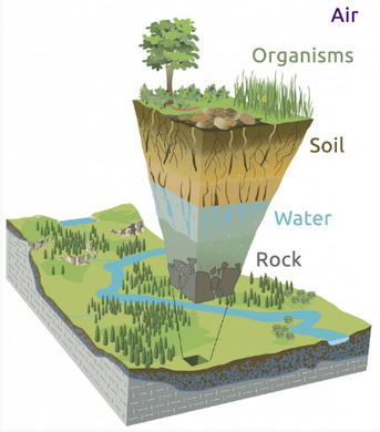
I recently had the pleasure of addressing PLAM attendees to elevate the nexus of the science behind their efforts with geology, including the concepts of Earth’s Critical Zone (above left, courtesy of criticalzone.org), Florida’s aquifer systems, and the water cycle. The presentation helped broaden the understanding of land management and acquisition in terms of broad temporal and spatial scales of hydrogeologic processes.
Factors that influence ecosystem health, including groundwater recharge, discharge and levels, extend far laterally and well beneath the land surface that has been set aside for conservation. “Land” is the skin of a block of earth and it is all connected. For example, over long periods of time, nutrients like carbon and nitrogen cycle between plants and soils, and soils are derived from shallow geological layers of rocks, sediments and their constituent minerals.
Likewise, timescales of geological processes range from short-term, such as flooding and groundwater-conduit flow (think springs), to decadal processes, such as the increasing amounts of emerging contaminants in our groundwater or the effect that climate change will have on recharge of Florida’s aquifers. The interaction of surface water and groundwater within surface water bodies, was described to conference attendees to underscore the innumerable connections between ecosystems, Florida’s water resources, and the “bucket that holds the water” - our geologic framework.
As often occurs in this type of presentation, some were surprised that more than 90 percent of our drinking water comes from groundwater, but not from vast underground water-filled caverns. Instead, it is predominantly the barely visible interconnections in rock and sediment porosity that allow subsurface storage and movement of groundwater. By learning that “everywhere you stand in Florida there is an aquifer under your feet,” attendees could better relate the importance of aquifer recharge and the interplay of human activities that influence water quality and quality.
Additional geological information can be considered when acquiring lands for protection and conservation,. With Florida being “topographically challenged” as compared to mountainous terrains, geological outcrops are few and far between. Exposures of Florida’s subsurface layers are important resources to be protected. In addition, Florida has some of the most outstanding karst features in the world, including more springs and sinkholes than almost anywhere else on the planet!
Coupled with sinkholes is the concept of aquifer vulnerability, which closely relates to aquifer recharge: sinkholes can offer rapid vertical pathways for contaminates to enter the groundwater system. Further, there are unique and significant geologic ties to our cultural heritage dating back to Florida’s first peoples, Paleo Indians. Early generations of inhabitants relied on rocks for tools and weapons, clay for pottery, caves for protection, soils for agriculture, and spring pools, streams and rivers for drinking, transportation, fishing and commerce. These are some of the more substantive connections between geology and conservation of our lands and heritage.
Contact: Dr. Jonathan Arthur, P.G., FGS Director and State Geologist
Back to top
|
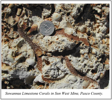
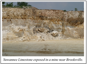 Geologic formations are the basic rock units that are used in stratigraphy, the branch of geology that deals with the layers of sedimentary rock that have accumulated over geologic time (also known as “strata”). Cooke and Mansfield (1936) proposed calling the yellowish limestone exposed along the Suwannee River from Ellaville to near White Springs the Suwannee Limestone. Like many limestone formations in Florida, the first descriptions of the Suwannee Limestone were based on fossil assemblages. Fossils were commonly used to correlate geologic units across broad areas of the Gulf and Atlantic Coastal Plain, from Mississippi to South Carolina, and less attention was paid to the lithologic components. Additionally, Cooke and Mansfield did not designate a type section for the Suwannee Limestone but identified a broad area where the formation crops out. This made it difficult for geologists to compare rocks from other areas to a known section of Suwannee Limestone, which led to inconsistent use of this formation name.
|
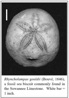 Since Cooke and Mansfield’s naming of the Suwannee Limestone in 1936, other geologists have investigated various aspects of this formation. Studies of the fossil assemblage contained within the Suwannee Limestone confirmed an early Oligocene age (33.9 – 28.1 million years ago). One of the age-diagnostic fossils commonly found in the Suwannee Limestone is the sea biscuit Rhyncholampas gouldii (Bouvé, 1846). Other fossils include mollusks, foraminifera, and coral. Studies conducted on the petrology and mineralogy reveal that the Suwannee Limestone was originally deposited in a shallow, marine environment where wave action and fluctuating sea level affected the size and composition of the grains that comprise this unit. Over geologic time, portions of the Suwannee Limestone have been altered by geochemical processes (called diagenesis) to dolostone, which further complicates the identification of this formation.
|
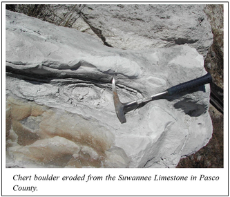 The Suwannee Limestone is typically a yellowish to cream colored, poorly- to well-indurated, variably fossiliferous, moldic limestone. Some parts of the formation contain chert and dolomite. The Suwannee Limestone crops out or occurs near the land surface from southern Jefferson County to coastal Taylor County, along the upper Suwannee River, and in parts of Hernando and Pasco counties. The formation occurs in the subsurface across much of South Florida where it attains a thickness of 400 feet or more. It is absent from northeast Florida. The Suwannee Limestone has been identified in the Florida panhandle, but more recent interpretations of the geology of this area show that it grades into other geologic formations of the same age (Marianna Limestone and Bridgeboro Limestone). Where the Suwannee Limestone occurs, it comprises an important upper part of the Floridan aquifer system.
|
 Silver Springs State Park, located in central Marion County, preserves approximately 5,000 acres of land surrounding this world-famous spring. In fact, the park showcases 30 springs, collectively called Silver Springs Group, that discharge hundreds of millions of gallons of groundwater to the Silver River. The water emerges from ancient limestone formations that comprise the upper part of the Floridan aquifer system, which is the source of water for hundreds of springs around the state, including some of the largest and deepest springs in the world. Silver Springs State Park provides visitors the opportunity to peer into this vast and complex underground reservoir and explore the surrounding landscape and ecosystems associated with one of Florida’s largest spring systems.
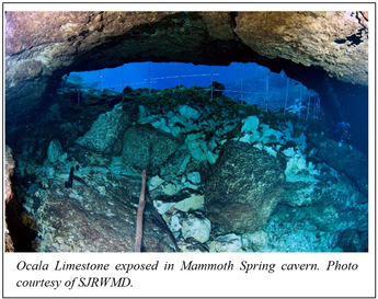
The rock formation exposed in Silver Springs is called the Ocala Limestone. It is named for the city of Ocala where the limestone formation was first described. The Ocala Limestone is a white, chalky, highly fossiliferous limestone that was deposited in a warm, shallow marine environment more than 35 million years ago. Countless remains of sand dollars, sea biscuits, clams, snails and single-celled organisms called foraminifera accumulated on the sea floor over millions of years and ultimately became cemented together forming the Ocala Limestone. Some of these fossils can be observed in the limestone boulders scattered throughout the park.
|
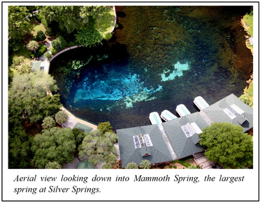 Mammoth Spring is the largest spring in the Silver Springs Group and is one of more than 1,000 springs known to exist in Florida. Mammoth Spring is the large spring adjacent to the boat basin where the glass-bottom boats dock. As you peer into the depths of Mammoth Spring from a glass-bottom boat, you will see the large cave from which groundwater emerges. The springs and caves in Silver Springs State Park formed as the Ocala Limestone slowly dissolved away over thousands to millions of years. This process is responsible for creating what geologists call karst topography. Karst is a term used to describe landforms that occur in areas where limestone has been partially dissolved by slightly acidic groundwater, leaving behind holes in the rock. When the holes in the limestone bedrock become large enough to collapse, the land above them subsides and a sinkhole forms. When water levels in our limestone aquifers are high enough to force water out of a sinkhole, it becomes a spring! Springs, sinkholes and caves are karst features that form as the result of dissolution and are common landforms in areas that have karst topography. Silver Springs State Park contains amazing examples of karst features that make Florida unique.
Contact: Harley Means, P.G. Administrator
|
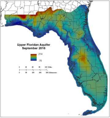 The FGS Applied Geoscience Services Section continues to produce statewide potentiometric surface maps of the upper Floridan aquifer on a semi-annual basis. The maps are produced for the months of May and September from water-level data collected by the state’s five water management districts, Alachua County, the Geological Survey of Alabama, and the U.S. Geological Survey. The first map produced was the September 2012 upper Floridan aquifer potentiometric surface. It resides in a geodatabase containing both historic and current potentiometric surface data. Access to the data is through the department’s Open Data Portal.
In the Open Data Portal, you can find contour lines, wells with associated water level measurements, and raster surfaces that can be downloaded in several different formats including geodatabases and shapefiles. Further information regarding the methods used to develop these maps can be found in the Florida Scientist, v. 79, no. 4, p. 257-268.
In late April 2018, the FGS completed drilling of a well located behind its main office on Commonwealth Boulevard in Tallahassee, Florida. This water-level data will add to the well network of the potentiometric surface maps. The well was drilled to a depth of 855 feet and was completed in the Ocala Limestone. The well will be used to test geophysical equipment and is currently being monitored by FGS staff for water-level measurements. This has provided a fantastic opportunity to train FGS staff interns on the proper methods and techniques to obtain accurate water-level measurements and the maintenance of data. A server has been set up and programmed to read an embedded Google Sheet. The display shows the output table of measurement readings and a plot of the depth to water. Soon, the FGS will drill an upper Floridan aquifer well (less than 200 feet deep) adjacent to this well that will be added to the upper Floridan aquifer well statewide network.
Coming soon, the FGS will embark on a project to map other aquifer systems within the state, including the Biscayne aquifer, Sand-and-Gravel aquifer, and the intermediate aquifer system.
Techniques used to develop these layers will be based on those used to map the upper Floridan aquifer.
Contact: Jim Cichon, P.G.
|
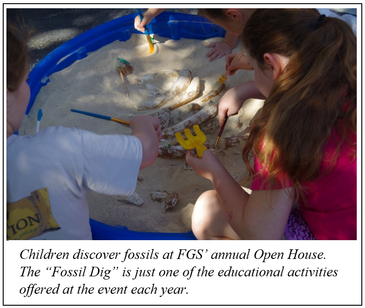 When Hurricane Michael hit the Florida panhandle, the FGS Earth Science Week Open House celebration scheduled for October was put on hold. It has now been rescheduled for Saturday, Dec. 8, from 10 a.m. until 3 p.m. at 3000 Commonwealth Boulevard in Tallahassee. The event will be the first FGS Open House to be held on a Saturday. It will offer multiple exhibits for all ages and the FGS Museum, which features a dugong skeleton, an extinct mako shark jaw, and many examples of Florida rocks, minerals and fossils. Participants will be able to watch a drill rig demonstration, examine samples through microscopes, and discover the history of maps in the GIS lab. Young participants can learn how fossils form, and all visitors are welcomed to “paint-a-rock” as part of this year’s “Earth as Inspiration” theme. Sixth through ninth grade students have a chance to win a “prize that rocks” if they participate in FGS’ first-ever writing and art contest.
|
 The Open House will mark the end of a very successful outreach and education year for the FGS. Earlier in the year, P.G. Administrator Harley Means shot a video segment for the Florida Channel at Lake Miccosukee Sinks. The video featured a hike to two sinkholes on Lake Miccosukee in Tallahassee, which were exposed due to low rainfall, allowing a unique opportunity to explore the lake’s connection to the Floridan Aquifer. FGS P.G.s also provided numerous lectures and appeared on panels for students from Florida State University, Stetson University, University of Florida, University of South Florida, and even the University of Tennessee on a variety of geologic topics including karst in Florida, STEM careers, and geohazards.
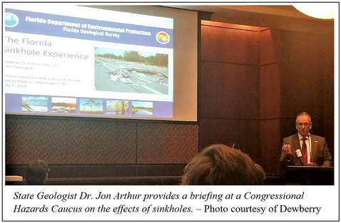
During the spring, Director and State Geologist Jon Arthur participated in a sinkhole panel of the Congressional Hazard Caucus Alliance held at the U.S. Capitol. Dr. Arthur served on a panel with representatives from the U.S. Geological Survey and NASA. The Caucus was attended by almost 40 representatives from U.S. House and Senate committees, scientific organizations, and federal agencies. Presentation topics included effects of Florida sinkholes relating to human health and safety, as well as economic and environmental effects. Although sinkholes are common in Florida, only a few dozen people are adversely impacted per year, on average.
FGS professional geologist Dr. Christopher Williams participated in a county-wide Brain Shop Summer Series at the Dr. B.L. Perry Jr. Branch Leon County Public Library during the summer. Florida residents of all ages joined Williams to discuss rocks, fossils, geomorphology, and LiDAR in the Capital Region (Leon, Wakulla, and eastern
Gadsden counties) of Florida. Attendees learned how understanding geology is essential for mineral and water resource protection and conservation. Later in the summer, Dr. Arthur spoke to hundreds of children and adults at the Belleview Public Library. Topics included Florida rocks, fossils, groundwater, and the role of geology in environmental protection. The presentation was well-received, and three children declared their desire to be geologists when they grow up.
Throughout the year, FGS provided university, public and secondary educational groups with opportunities for field trips to the FGS museum and repository as well as geologic sites of interest around the region, including Leon Sinks, Jackson Bluff, the Apalachicola River, and various springs and state parks. Various environmental groups, advisory groups, senior groups, and even state and local government organizations also took advantage of the outreach services that FGS offers. For example, Dr. Arthur presented “Fingerprints on our Groundwater” to Florida Department of Health employees in Hillsborough County Environmental Health Services, allowing attendees to learn how aquifers work, factors that affect groundwater vulnerability and how newly discovered types of contaminants such as pharmaceuticals, personal care products, hormones, and detergents can enter the groundwater system. Attendees learned what DEP is doing to better understand these contaminants for improved environmental and public health protection.
Contact: Sarah Erb, Operations Manager
|
|