|
Welcome to the October 2021 edition of FGS News and Research. It has been 10 months since our last release, and the FGS has had an exciting and productive year.
After 33 years of service to the state of Florida and 13 years as FGS director and State Geologist, Dr. Jon Arthur has assumed a new role as the executive director of the American Geosciences Institute. Dr. Arthur served the people of Florida with distinction and vision and his leadership provided a firm foundation for the next director and State Geologist to build on. I was honored to be named the acting director and State Geologist in July and I have full confidence in the amazing team that I have been a part of for over 25 years. Learn more about Dr. Arthur’s fascinating career in this issue.
Providing access to geologic samples and data is the core of the FGS mission. In the wake of pandemic restrictions, the FGS hired its first sample collections curator and reopened its doors to the public under a new name: The Florida Geological Survey Sample Collections Facility. As part of a federal grant project, the FGS provided the public with access to 302 historically significant Florida field books – some dating back to 1905. You can read more about our collections facility and contents of these field notebooks below.
You are never too young or too old to learn more about our natural systems. Below, you can learn about the geology of Hillsborough River State Park and discover why the informal lithostratigraphic unit Tertiary/Quaternary shell-bearing sediments is used in Florida.
At the FGS, there is always something to get excited about. In August, a rare drydown event at Lake Jackson in Leon County provided a unique opportunity for our geoscientists to conduct a dye trace at Porter Hole Sink in partnership with the Northwest Florida Water Management District. Dye trace studies allow us to learn more about groundwater flow in the underlying Floridan aquifer system. We anxiously await the results of this study and will share them in a future issue.
We will be celebrating Earth Science Week (Oct. 10-16) and plan to run field trips to Cherokee Sink at Edward Ball Wakulla Springs State Park on Oct. 15, 2021. Space is limited, so please register as soon as possible.
Although we have not yet detected dye from the Porter Hole Sink dye trace, who knows what could happen between now and then? The dye could make it to Wakulla Springs!
Regards,

Guy H. Means, P.G. Administrator
Acting Director and State Geologist
Florida Geological Survey
Florida Department of Environmental Protection


People go to Hillsborough River State Park to enjoy recreational activities, including camping, kayaking, canoeing, fishing and hiking. Several miles of the Florida Trail are within the park, connecting the historic Fort Foster, an important strategic defense point during the Second Seminole War, to the rest of the park along the U.S. Highway 301 corridor.
Inside the park, the Hillsborough River flows from northeast to southwest, encountering silicified limestone shoals and swamps densely forested with sabal palmettos as it meanders through pristine wetland habitats. The headwaters of the Hillsborough River are in the Green Swamp to the northeast of the park near Zephyrhills. Just three miles upstream from the park is Crystal Springs, a magnitude 2 spring system that discharges approximately 30 million gallons per day into the Hillsborough River.
These clear waters originate from the highly productive Floridan aquifer system (FAS). The FAS in this region is semi-confined to unconfined, meaning that there are little to no overlying sediments which, when combined with the high potentiometric surface of the FAS in this area, means ample flow from the aquifer to the springs and river systems. (The potentiometric surface is an inferred water level based on the pressure exerted on groundwater at depth in an aquifer.) After leaving the park, the Hillsborough River winds through the city of Tampa before entering the large estuary of Tampa Bay.
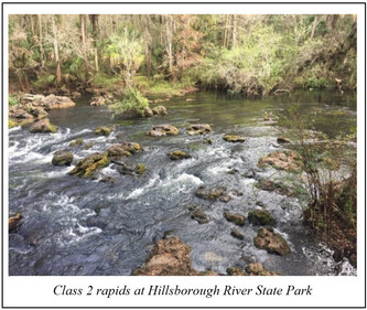
The unique hydrology and geology at Hillsborough River State Park support a lush ecosystem containing endemic plant and animal species enjoyed by thousands of park visitors each year. Some of the most visibly interesting geological features are the rapids on the upper stretch of the river inside the park. These rapids are caused by the flow of water over the erosion-resistant, partially silicified sections of the Oligocene Tampa Member of the Arcadia Formation of the Hawthorn Group exposed along the riverbed and the banks of the upper Hillsborough River. The Tampa Member is a limestone that ranges from soft and micritic to hard, crystalline limestone and contains an abundant marine invertebrate fossil assemblage and small amounts of sand. More so than other rocks, limestone, which is comprised of calcite (CaCO3), is subject to chemical weathering or erosion due to the chemical process of dissolution. However, when limestone has been partially or entirely silicified (a process by which silica replaces other minerals in a rock), it becomes much more resistant to this form of chemical weathering. Silica is much harder and more erosion-resistant than the calcite in limestone, leaving a more durable layer of silicified rock.
Contact: Casey Albritton, P.G.
|
Geologic formations are the basic rock units used in stratigraphy, the branch of geology that deals with the layers of sedimentary rock (called strata) that have accumulated over geologic time.
Tertiary/Quaternary shell-bearing sediments (TQsu) is an informal lithostratigraphic term first used by Scott et al. (2001) and is comprised of fossiliferous sediment that accumulated during the late Pliocene through Pleistocene epochs in southern Florida.
In the early 20th century, many geologists working in southern Florida used the fossil assemblages (biostratigraphy) in these sediments as indicators of a specific formation. As a result, some of the Plio-Pleistocene formations in this area are considered informal lithostratigraphic units. To simplify the stratigraphic nomenclature of South Florida and avoid using these “biostratigraphic” formations, the term “Tertiary/Quaternary shell-bearing sediments” was adopted by the Florida Geological Survey. This informal unit is shown on the most recent geologic map of Florida (Scott et al., 2001).
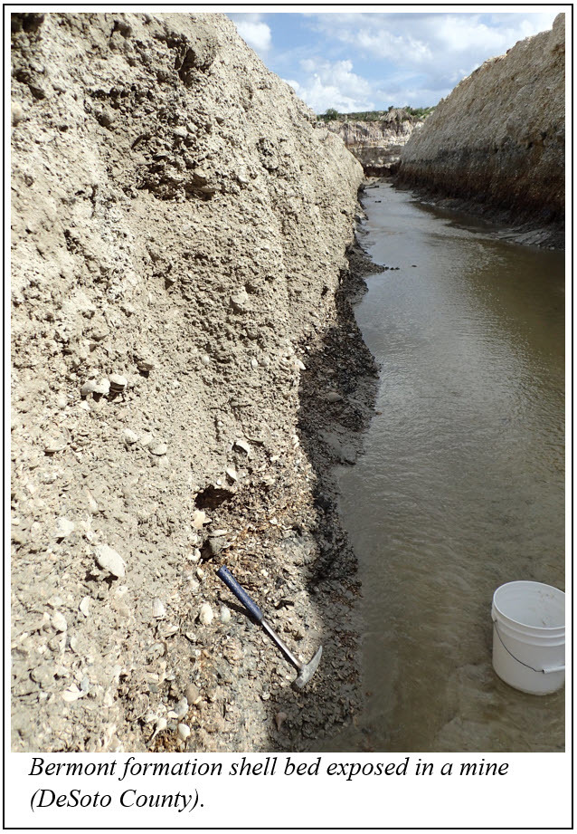
The Caloosahatchee, Bermont and Fort Thompson formations are the biostratigraphically defined formations that now comprise the TQsu. The extent and thickness of these units are highly variable, and natural exposures are limited due to the low topographic relief in South Florida. Mining operations commonly target these fossiliferous strata to obtain crushed fossil shells for construction materials. Molluscan paleontologists have also been drawn to the high species diversity and excellent preservation of these fossil shell beds. It has been estimated that there may be more than 700 species of mollusks in the Caloosahatchee formation.
|
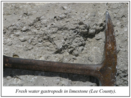
TQsu contains varying amounts of quartz sand, silt and clay mixed with abundant and usually well-preserved fossil shells. Minor amounts of phosphate and heavy mineral grains can occur. The shelly sediments are occasionally cemented together into rock, creating “hard pan” zones representing paleo water table elevations. The marine shelly sediments that comprise the TQsu are interbedded with thin layers containing freshwater mollusks in a carbonate matrix. These freshwater limestone deposits accumulated in wetlands like the modern Everglades. Where preserved, the alternating marine and freshwater deposits reflect the climactic and sea level variations that occurred as continental glaciers advanced and retreated over the past 2.6 million years. This time period is commonly referred to as the Ice Age.
References:
Scott, T.M.; Campbell, K.M.; Rupert, F.R.; Arthur, J.D.; Green, R.C.; Means, G.H.; Missimer, T.M.; Lloyd, J.M.; Yon, J.W.; and Duncan, J.G., 2001, Geologic Map of the State of Florida, Florida Geological Survey Map Series 146, 1 plate. doi.org/10.35256/MS146
Contact: Harley Means, P.G. Administrator
|
Geologists and paleontologists have always collected samples of rocks, fossils and sediments as reference material for their investigations. For many decades Florida statutes have directed the Florida Geological Survey (FGS) to “make collections of specimens illustrating the geological and mineral features of the state.” The FGS was to keep one set of these specimens and send a duplicate set to each of the state colleges for “convenient use and study.”
With the discovery of oil in the early 1900s, oil companies began to drill exploratory wells in Florida, frequently many thousands of feet deep. The oil well drillers collected the small pieces of rock made by the drill bit’s passage, called cuttings, to identify the type of rock the drill bit was boring through.
To get even better information, drillers developed tools that allowed them to drill using hollow tubes that produced a cylinder of rock or sediment, known as core. Core could be used to identify exactly how deep an oil-bearing formation was located. Cuttings and core are also useful for investigating mineral and water resources; defining geologic; hydrogeologic and engineering properties; identifying geologic hazards; and other uses. Because drilling can be expensive, particularly for very deep wells, it made sense to store cuttings and core for future investigations.
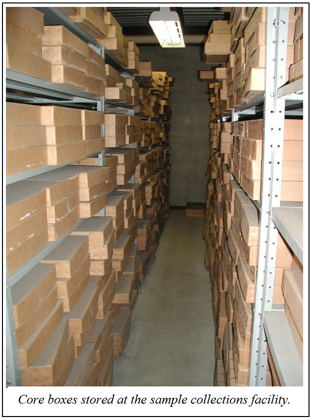
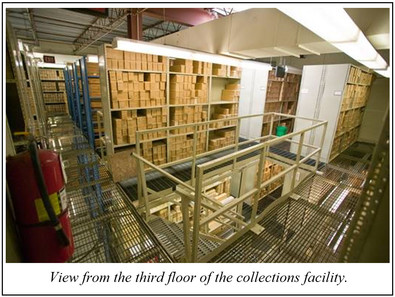
As the FGS collected more and more samples it became necessary to expand the storage beyond what could be held within the library, offices and small storage rooms available at the FGS headquarters. In 1983, the FGS well cuttings and cores were moved into a three-story facility, identified as “Geology – Sample Depository,” inside a warehouse shared by several Department of Natural Resources programs.
In the 1990s, the Florida Legislature updated and expanded the directive for collection and storage of geologic specimens, including core and cuttings. Today, Chapter 377.075(5), Florida Statutes, directs that “The staff shall operate and maintain a central, statewide repository for such specimens, for well cuttings and cores and related surface and subsurface samples, and associated data.”
The collection facility has added storage space several times since 1983 to meet that directive. Rolling shelves were installed in 2004 and 2008 on the ground floor. In 2016, 8,000 square feet of additional space on the second floor of the warehouse was made available to the FGS to increase the facility’s storage capacity to over 21,000 square feet. This space had previously been used to house paper records that were no longer needed due to DEP divisions going digital.
Currently, an additional 3,000-square-foot storage area is being converted to shelving on the second floor. This leaves the FGS as the primary tenant of the building with over 24,000 square feet of geologic sample storage. Additional space will be needed to archive the growing collection that now includes over 16,500 unique borehole samples from across the state.
Scientists and researchers from state and federal agencies, academia, consulting companies and industry can access these geologic samples by scheduling a visit to the facility. More in-depth investigations requiring portions of a sample for analysis are approved on a case-by-case basis. The FGS receives the results of these analyses and makes them available to the public, thus increasing and improving our understanding of the geologic and hydrogeologic framework of our state.
A collection facility grows by adding to and maintaining the samples it already has in storage. As Florida’s population has grown, the rate of new sample submissions has increased, thus increasing the need for additional maintenance. In late 2019, then FGS Director and State Geologist Dr. Jon Arthur initiated a thorough and in-depth analysis of workflows, processes and procedures related to the collection and management of the geologic samples in the collection facility with the goals of improving efficiency, accountability and sample inventory control. From that analysis came a range of recommendations for changes in process and procedures and the need to supplement the single full-time staff member and part-time helper with another full-time position. There was a need for someone with the skills and experience to update and develop efficient standard operating procedures; organize and direct the receipt, processing and maintenance of the samples; and manage the requests for access to the samples from FGS and outside researchers. This led to the creation of a full time-position from elsewhere within the FGS to aid in the effort.
|
Visitors to the facility will see a new name above the reopened doors: Florida Geological Survey Sample Collections Facility. Dr. Arthur selected this name to clearly reflect the nature and purpose of the facility. The FGS Sample Collections Facility also welcomed its first FGS collections curator, Edward Chelette, who joins the other facility staff, Jesse Hurd and Robert “Ned” Spears. After graduating with a Bachelor of Science degree in geology from Florida State University and attending graduate school at both FSU and the University of Hawaii, Edward served seven years as an IT professional, two years as an FGS OPS field technician hunting swallets across north and central Florida and, most recently, as the field services section manager for the Northwest Florida Water Management District, responsible for collecting and managing all the district’s hydrological data and data collection staff. Edward brings with him a love of problem solving, a dedication to customer service, and, as he is fond of saying, “the ability to lift heavy things.”
|
For more information about the FGS Geologic Sample Collections, check out our website at FloridaDEP.gov/FGS/Geologic-Collections or contact Edward Chelette, curator.
Back to top
The Florida Geological Survey has scanned 302 historically significant Florida field books and placed them online for public availability as part of a 2019 federal grant awarded through the USGS National Geological and Geophysical Data Preservation Program. The scope of work included digitizing the FGS field book collection, transcribing as many of the collection’s oldest and most fragile books as possible, and making digital files available via the National Digital Catalog and the FGS website.
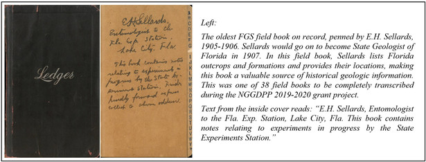
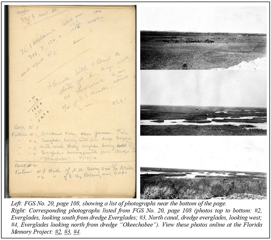
The earliest geologists of FGS traveled throughout Florida, capturing field data using field notebooks. Entries found in the FGS collection include outcrop locations and descriptions; elevation information; exposure and sample descriptions; photo indices; water quality reports; mining operation summaries; and topographical descriptions. This information was subsequently used in many of the survey’s publications. The oldest known books date back to 1905, predating the official establishment of the survey in 1907.
The field books were first separated into six sub-collections based upon the author, time period, subject or a combination of these characteristics:
- Sellards-Gunter Books.
- Geologist Field Books 1905-1930.
- Geologist Field Books 1960-2000.
- Elevation Surveys 1949-1970.
- Drilling Operations Log Books.
- FGS Funded Projects.
Named for its two main authors and two of the FGS’s earliest State Geologists (E.H. Sellards and Herman Gunter), the Sellards-Gunter sub-collection is composed of 39 books dating from 1905-1918. This sub-collection combines two previously numbered series of the FGS’s oldest field books (“FGS No. 1–FGS No. 34” and “Gunter Notes”) with other books by the same authors. Of the 39 books in this sub-collection, 38 were fully transcribed to preserve their valuable geologic information. Due to limited transcription and QA/QC time requirements, the 39th book, “FGS No. 5,” which contains no field notes, was not transcribed.
After being scanned, the Sellards-Gunter books were transcribed from portable document formats (PDF) into Microsoft Word files. Each file was structured similarly using the following format: a header listing the book’s number and/or title; a general overview describing the page numbering system and the approximate number of pages transcribed; year(s) written; writing medium; standout features of the book’s structure (such as a large number of tables); and finally, a page-by-page transcription of the book’s text.
Field books that were not fully transcribed and contained valuable well and sample data were examined for content and entered into a spreadsheet listing the file name, author(s), year range and general topics, including brief location or sample information. This spreadsheet was then used to create metadata for the National Digital Catalog listing and sub-collection landing pages for the FGS website.
As transcriptions were completed toward the end of the project, more in-depth indexing was also conducted, including creating text files listing basic metadata, additional tags and sample references. These index sheets will be added to the PDF files for quick reference.
Although the FGS field book transcription project was fulfilling, it was not without its challenges.
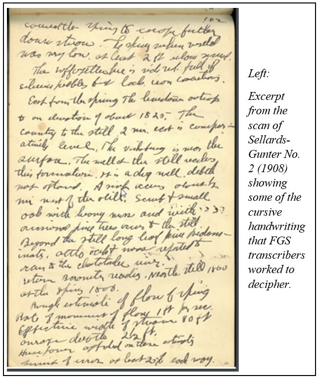
Many younger staff members had difficulty comprehending the often flowery or messy cursive handwriting in older field books. Others struggled to distinguish correct names for Latin species, companies and antiquated geographic location terms. Nevertheless, staff geoscientists assisting with transcription cleanup deciphered such terms and solved many textual mysteries.
At the end of the project, staff geologists who helped check the transcriptions were asked to fill out a survey. From that survey, 86% said they learned something new about Florida, 71% agreed that the field books would provide helpful information for future projects, and 100% learned lessons about keeping better field notes.
FGS geoscientists also listed the following potential societal benefits from the project:
- Provide historical geological information for areas that may now be more developed and therefore less exposed.
- Offer information on specific interests (for example, recounted trips on Florida’s waterways could be intriguing to kayaking groups and other Florida enthusiasts, while fossil and mineral localities may be of interest to Florida “rockhounds”).
- Give a unique and in-depth historical perspective on early geologic investigations, including the early descriptions of mining, ecology, archaeology and paleontology.
- Serve an anthropological use in terms of the information about the geologists making the notes, including recorded activities, mode of travel, mode of speech, writing style, and interactions between staff and historical figures, including famous scientists and politicians.
The process of identifying, scanning, transcribing and cataloging field book information has made these valuable resources discoverable without the risk of damaging the original documents. In addition to being available on our website, information from these field books will be shared through outreach events and future projects.
Contact: Kathryn Etheridge, Ph.D.
|
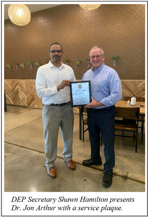
After 33 years of service to the state of Florida and 13 years as Florida Geological Survey director and State Geologist, Dr. Jon Arthur retired to assume a new role as the Executive Director of the American Geosciences Institute (AGI).
During his 13 years as director, the FGS made tremendous strides in geoscience research, geologic data preservation, and outreach and education. Dr. Arthur represented the department in leadership roles for national scientific committees and provided technical presentations ranging from congressional testimonies and graduate school lectures to outreach presentations for young K-12 aspiring geoscientists.
Dr. Arthur started his career at the FGS as a Geologist II in 1988 and received a Bachelor of Science degree and a Ph.D. in geology from Florida State University. His passion for Florida’s natural resources and his leadership ability allowed him to rise rapidly through the ranks to become director and State Geologist in 2008. As part of his role as State Geologist, Dr. Arthur served on the Board of Professional Geologists and provided hundreds of talks about geoscience to students ranging from first grade through graduate school levels. He focused his research and leadership on providing geoscience information to understand natural systems, improve environmental stewardship, and address societal and environmental concerns.
Dr. Arthur's esteem for all FGS staff members as part of a proud, 114-year-old institution was always reflected in his high expectations and confidence in his employees. This type of leadership inspired superior performance and innovation regarding improved access to data and expansion of the FGS Sample Collections Facility.
Throughout his successful career, Jon has published more than 40 scientific papers, given congressional briefings and testimony, keynotes and technical presentations, including international workshops on karst geohazards, water-rock geochemical interactions, and geologic data preservation. Dr. Arthur’s research interests include hydrogeochemistry, aquifer vulnerability, geoscience policy, public engagement, and the application of geosciences to address societal and environmental concerns.
These passions will be carried on with Dr. Arthur’s new role as the executive director of AGI. The department and the staff of the FGS thank him for his dedicated service and outstanding leadership and wish him well in his new role.
Contact: Sarah Erb, MBA
|
Back to top
|