|
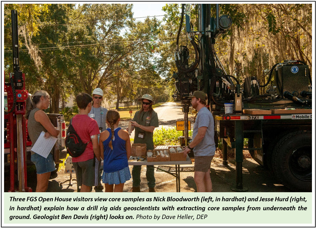
Welcome to the November 2022 edition of FGS News and Research, packed with exciting announcements and dynamic, engaging geoscience information. Last month, FGS accomplished a milestone by reaching nearly 500 Floridians during Earth Science Week. Our Open House provided an opportunity to showcase the FGS’ new drill rig, which was received earlier this year from Mobile Drill. It will be used to collect borehole samples, drill and install monitor wells, and increase drill crew safety and work efficiency while reducing maintenance and operational costs. Florida’s low topography and limited geologic exposures are reasons why we rely on borehole samples to provide critical subsurface geologic information about our state.
After years of hard work and anticipation, I am thrilled to announce the release of FGS Special Publication 59, “The Florida Geomorphology Atlas,” which is available on our home page under the Quick Links menu. The atlas is our first fully digital publication and includes a web-based, interactive map that enables users to browse areas of interest. The online atlas is the first publication with a systematic listing and description of statewide, regionally classified landforms whose boundaries have been discretely and rigorously defined. In this issue, read up on how the map allows you to explore and learn at your own pace.
Other articles below also provide opportunities to learn. Get a lesson in lithostratigraphy as we discuss two lower Miocene formations: The Chattahoochee Formation and the St. Marks Formation. Florida’s unique geology is bound to surprise you. Did you know that Florida has Class III whitewater rapids? If you do not believe me, check out the article on the geology of Big Shoals State Park!
Finally, it saddens me to share that a revered FGS employee, Guy Richardson, passed away in June. While we continue to mourn his loss, Guy’s 16-year career in the FGS Drilling Operations program showed his exemplary dedication to public service. I invite you to read about his many accomplishments and legacy.
Sincerely,

Guy H. Means
Director and State Geologist
Florida Geological Survey
Florida Department of Environmental Protection

Earth Science Week (ESW) is a national event organized by the American Geosciences Institute (AGI). This year, ESW was celebrated from Oct. 9 – 15 with the theme "Earth Science for a Sustainable World.”
Since ESW’s inception in 1998, the Florida Geological Survey (FGS) has celebrated the week on a local level by engaging with Floridians citizens through multiple events, including an Open House, a public field trip, interactive writing and art activities with educators and students, and field trips for local schools. This year, FGS set a new ESW record of interacting with 471 visitors during five events throughout the week.
Staff members dedicated time and resources to prepare and make the celebration a success. This year’s ESW outreach events are detailed below.
Sustainability Drawing: What does “sustainable” mean to me?
Leon County Schools K-5 teachers were invited to enter their classrooms in the FGS Earth Science Week Sustainability Drawing. Six classroom teachers submitted 81 artwork pieces that were displayed at the FGS headquarters.
Four classrooms were selected as the winners of the drawing. Each of them will receive a visit from a geologist, complete with the FGS traveling children’s library, a Florida minerals poster, an AGI outreach kit, and an ammonite from Madagascar, donated by UC Minerals. Two additional classrooms were selected as runners-up and will receive a poster, outreach kit and an ammonite.
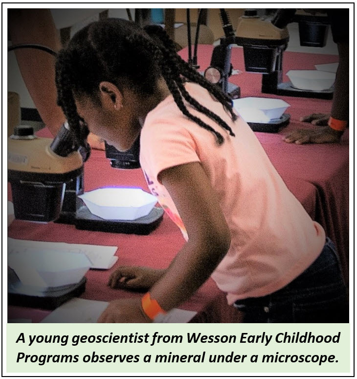
Wesson Early Childhood Programs Field Trip
Wesson Early Childhood Programs brought 74 pre-K students (plus 27 teachers and parents) to enjoy a “pre-open house” field trip to the FGS on Thursday, Oct. 13. Children were divided into five groups and rotated among five stations: “KidSpace” and Museum, Prehistoric Animal Sort and Tracks, Geologic Specimens, Paint-a-Rock, and Microscopes and Coloring Table. The stations were also available at the open house the following day.
Open House at 3000 Commonwealth Blvd.
The FGS annual Open House was held on Friday, Oct. 14, with 137 visitors, including colleagues from other parts of DEP. The event was covered by WTXL ABC News 27, and FGS Director and State Geologist Harley Means sent a message to FGS employees when the open house concluded. “I am proud to work with such a dedicated group of professionals. I was repeatedly told how amazing the exhibits were and how friendly and knowledgeable our staff members are,” he stated. “A lot of time and effort goes into the planning and execution of our Open House, and it shows in the response we get from our customers."
|
 |
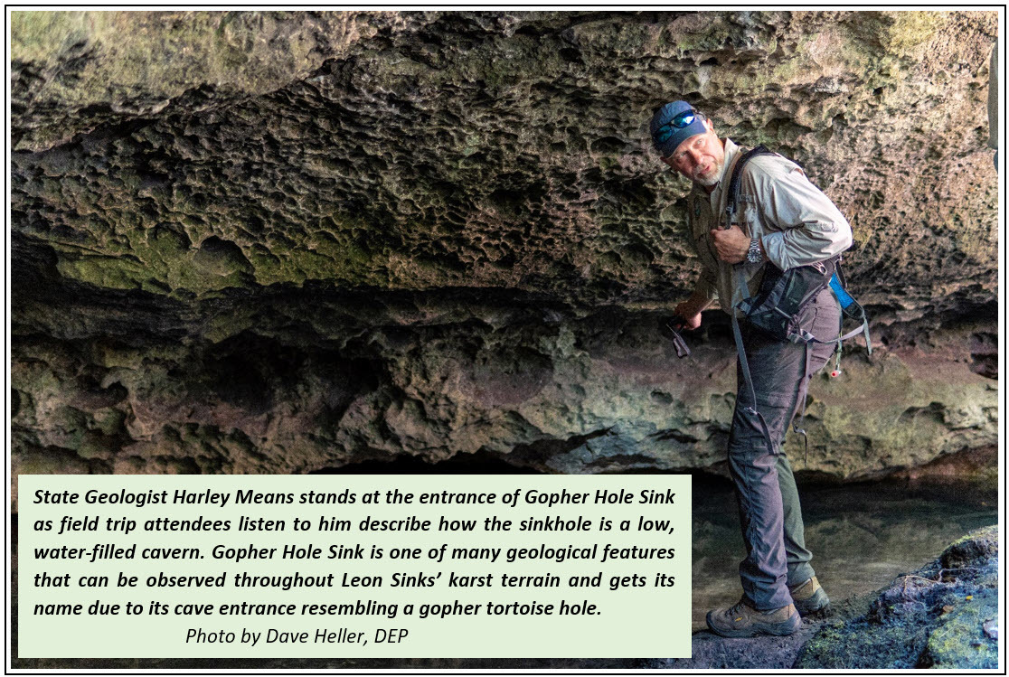
Public Field Trip to Leon Sinks
On Saturday of ESW, Harley Means led a 3-mile hike around Leon Sinks Geological Area for 30 attendees. Along the way, hikers learned about geology’s connection to the local ecosystem and about karst features including sinkholes, natural bridges and disappearing streams. The land’s terrain in this area is underlain by a layer of limestone, which is being eroded and dissolved by rainwater and groundwater to form caverns, holes and tunnels. This type of terrain is called "karst" and results in many geological features seen on the hike.
School of Arts and Sciences Field Trip
FGS provided 100 Leon County fourth- and fifth-grade students, plus teachers and parents, with a field trip to FGS headquarters. Spread out between a morning session and an afternoon session, groups enjoyed the FGS museum and drill rig, learned about the three primary rock types and Florida rocks and minerals, viewed rock and fossil specimens under a microscope, and participated in the “prehistoric animal sort” and Florida fossils stations. As a bonus, students expressed their creativity at the paint-a-rock station.
Although the FGS conducts most of its outreach during October, educational opportunities are offered throughout the year, including presentations, field trips and classroom visits. Learn more about FGS educational opportunities online.
Contact: Mabry Gaboardi Calhoun, Ph.D.
Back to top
Geomorphology is the study of landforms and how the evolution of these features has shaped the Earth’s surface. It involves identifying, describing and classifying landforms (particularly, the relationship of their geology and topography to the geologic processes that shape the landscape). Florida’s near-surface geology primarily consists of limestone overlain by siliciclastic (non-carbonate) sediments. These sediments form the surficial canvas that has been modified by coastal, aeolian, fluvial and karst processes to create the distinctive ridges, swales, dunes, marine terraces, marine escarpments, sinkholes, springs, karst escarpments and other karst landforms common to Florida.
The purpose of geomorphologic mapping in Florida is to ascertain how the geology and geologic processes have shaped the state’s unique landscape. Special Publication 59, “Florida Geomorphology Atlas” is the first publication with a systematic listing and description of statewide, regionally classified landforms whose boundaries have been discretely and rigorously defined.
Larger regions within the map are called districts. Districts in some areas of northern Florida have names that have been carried into Florida from earlier work in Alabama (Drahovzal, 1968) and Georgia (Clark and Zisa, 1976), but several newly defined districts are unique to Florida. Provinces are subregional classifications within districts that share spatially related landforms with a common set of origins.
The defined districts and provinces include areas that are correlated to near-surface geology that has influenced landform formation and notable landform and topographic distinctions at district and province boundaries. The geologic processes that have influenced landform development are also discussed.
The Florida Geomorphology Atlas allows readers to learn about the distinct landforms that are found throughout Florida and ascertain the landform variability and underlying geology unique to each geomorphic district and province. Special Publication 59 is not intended for site-specific applications. It is intended to paint a local and regional picture of Florida’s landforms and related geology and geologic processes that have shaped, and continue to shape, Florida as we know it today.
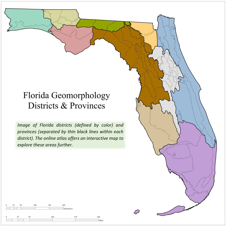 |
The Florida Geological Survey’s Special Publication 59, “Florida Geomorphology Atlas” is a digital publication with a webpage and a WebApp interactive map that enables users to browse and search areas of interest and link to specific, descriptive text for a selected district or province. The text can also be read cover-to-cover to gain statewide knowledge. There are many types of base maps one can use beneath the data to gain different perspectives. An elevation profile tool helps users visualize topographic change along a line across an area. The atlas is meant for exploring and learning at your own pace.
Contact: Christopher P. Williams, Ph.D., P.G.
Clark, W.Z., Jr., and Zisa, A.C., 1976, Physiographic map of Georgia: Georgia Department of Natural Resources, the Geologic and Water Resources Division, scale 1:2,000,000, 1 sheet.
Drahovzal, J.A., 1968, Physiography of Alabama, in Copeland, C.W., ed., Geology of the Alabama Coastal Plain, a guidebook: Geological Survey of Alabama Circular 47, p. 7-15.
Back to top
Geologic formations are the basic rock units used in lithostratigraphy (the branch of geology that deals with the study of strata). These formations are defined by the geologic materials, or lithology, that constitute them. Geological formations are also defined by their age, location and spatial extent. This article features two formations because they are what geologists refer to as time-equivalent units. During the same time in Earth’s history, both formations were deposited adjacent to one another, interfingering or grading laterally into one another over a mappable spatial extent.
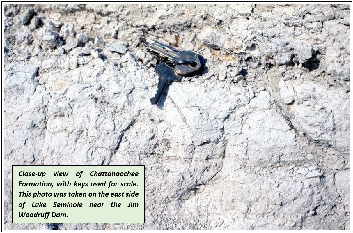
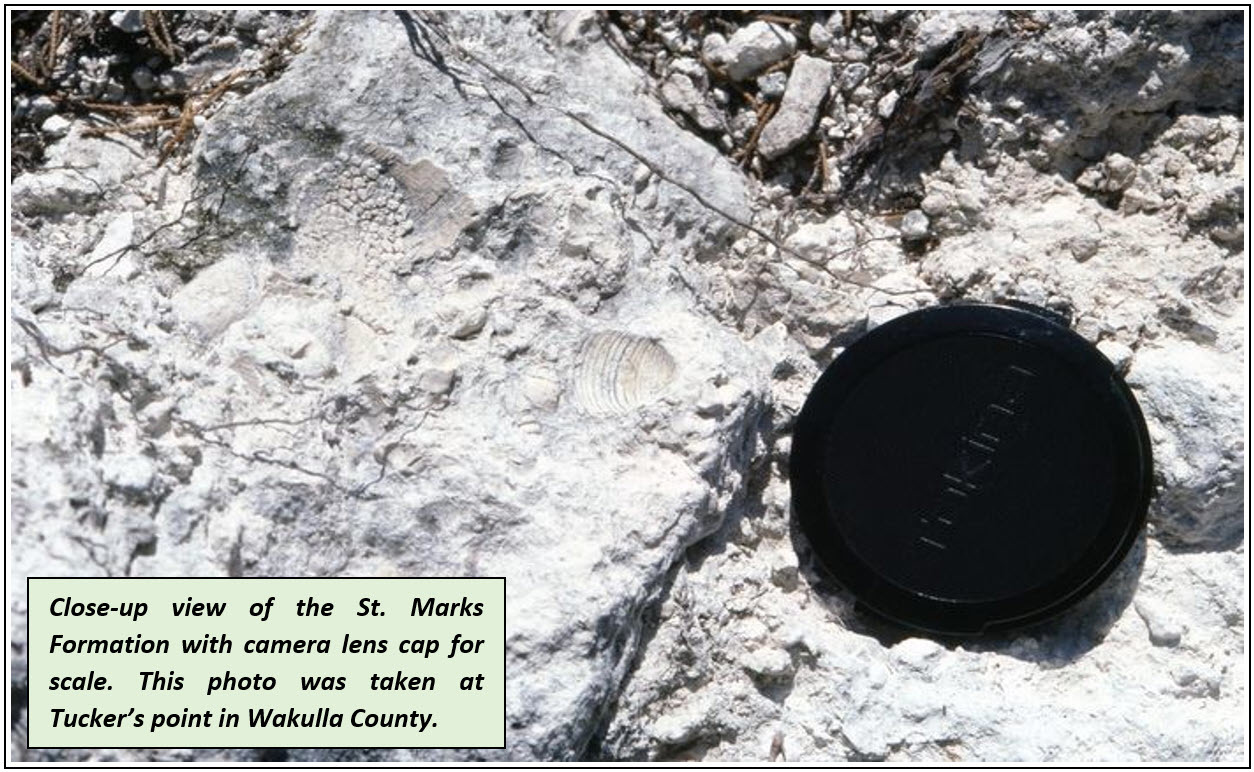
Geologist J. Finch formally recognized and named the St. Marks Formation in 1823. In 1894, Dall and Harris described the geology along the Apalachicola River and included the term “Chattahoochee limestone” in their descriptions. Both formations are composed of the sedimentary rocks limestone and dolostone. The formations are predominantly subsurface in the central to eastern Florida Panhandle. The type locality for the Chattahoochee Formation is located near the Jim Woodruff Dam in Decatur County, Georgia. The type locality for the St. Marks Formation is in Wakulla County, Florida.
A type locality is a specific geographical location where a sedimentary stratum is exposed and originally named, and where the lithological characteristics that distinguish the unit were first examined, described and identified. Both formations were deposited during the early Miocene between 23 and 20 million years ago.
The St. Marks and Chattahoochee formations have similarities. However, their lithologies (the distinguishable characteristics of their rock and sediment composition) vary within each formation, and the formations are distinguishable from one another. Geologists use a variety of characteristics to describe and distinguish carbonate lithologies. These characteristics include color, texture, grain type, fossil content, hardness, cement type, sedimentary structures and accessory minerals, among others.
The lithology of the St. Marks Formation, near its type section, was described by Rupert (1988) as pale orange to light gray to white, generally very fossiliferous limestone that is hardened and frequently contains dolomite. Rupert noted the occurrence of fossils such as the foraminifera Sorites sp. and Archaias sp. and numerous mollusk species.
Schmidt (1984) described the Chattahoochee Formation in Gadsden County as a very pale orange to light gray to white, hardened, silt or clay-sized dolostone and limestone. Fossils were common, generally as molds and casts. Schmidt noted that quartz sand and minor amounts of phosphate were present and that some zones were composed of fine-grained, sucrosic dolomite.
The Chattahoochee Formation occurs in a limited area in the central panhandle of Florida west of the axis of the Gulf Trough, which is a prominent subsurface structural feature in this area. To the east of the Gulf Trough, the Chattahoochee Formation grades laterally into the St. Marks Formation in Gadsden and Leon counties (Scott, 1986). These two formations are considered time equivalent and represent different depositional environments near the Gulf Trough during the early Miocene.
The St. Marks Formation is present in the subsurface of Jefferson, Leon, Gadsden and Wakulla counties. The Chattahoochee Formation is present in the subsurface of Gadsden, Jackson, Liberty, Calhoun, Bay, Washington and Holmes counties.
Contact: Scott Barrett Dyer, P.G.
References:
Dall, W.H. and Stanley-Brown, J., 1894, Cenozoic geology along the Apalachicola River, Bulletin of the Geological Society of America, Volume 5, pp. 147-170.
Finch, J., 1823, Geological essay on the Tertiary formation in America: American Journal of Science, v. 7, P. 31-43.
Rupert, F., and Spencer, S., 1988, Geology of Wakulla County, Florida: Florida Geological Survey Bulletin 60, 46 p.
Schmidt, W., 1984, Neogene stratigraphy and geologic history of the Apalachicola Embayment, Florida: Florida Bureau of Geology Bulletin 58, 146 p.
Scott, T.M., 1986, The lithostratigraphic relationships of the Chattahoochee, St. Marks and Torreya Formations, eastern Florida Panhandle: Florida Academy of Sciences, Abstract, Florida Scientist v. 49, supplement 1, p. 29.
Back to top
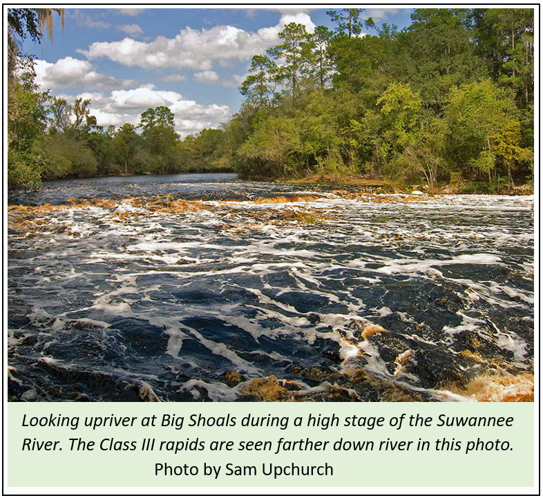
Over a length of nearly 600 feet, the Suwannee River loses 10 feet of elevation. That’s 1 foot down for every 60 linear feet as one travels downriver. Though this may not sound like much, when the river’s stage is between 59 to 61 feet in elevation, this elevation change is sufficient to create the only location in Florida with Class III whitewater rapid designation. According to the International Scale of River Difficulty presented by AmericanWhitewater.org, there are six classes of whitewater rapids increasing in difficulty and risk from one to six.
Why do rapids and shoals (shallow places in streams) exist in Florida? The answer is Big Shoals State Park’s unique geology!
Big Shoals State Park encompasses two tracts of land near each other along the Suwannee River in southeast Hamilton and northwest Columbia counties near White Springs, where the river’s shoals are composed of rock. Big Shoals State Forest, the property sandwiched between the park’s two tracts, is also public land. The eastern tract, upriver, is where the park’s namesake shoals are found. The western tract, downriver, is where a second and smaller set of shoals exist, appropriately named Little Shoals. Although it is fun to canoe or kayak over Little Shoals, it does not produce Class III whitewater rapids.
|
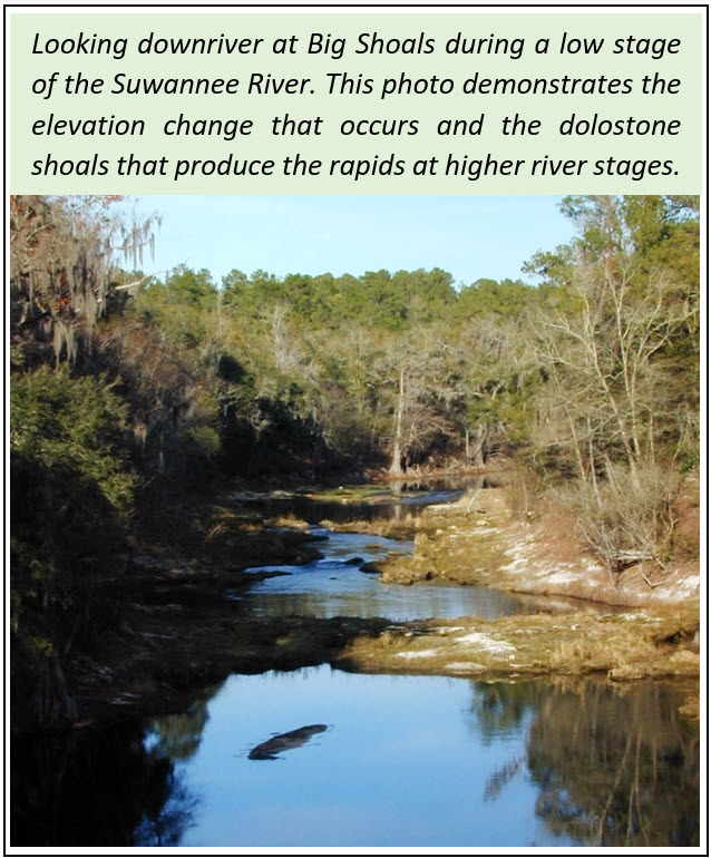
Except for along the river, the park’s tracts are blanketed by a thin layer of undifferentiated Quaternary (present day in geologic history) sands and clays that are generally less than 20 feet thick. The park is underlain by the middle to late Miocene Statenville Formation of the Hawthorn Group. Green et al. (2006) described the Statenville Formation as an interbedded sedimentary sequence of quartz sand, clays and dolostones with abundant phosphate grains. The Statenville Formation is mined in Hamilton County for its phosphate.
At a low river stage, accumulated phosphate and quartz gravel can be observed in the hollows of the dolostone shoals. Dolostone is a type of rock that is made up of calcium carbonate and is rich in magnesium. These carbonate rocks formed as a shallow reef environment when sea level was much higher. Unlike limestone, dolostone is very resistant to dissolution by naturally occurring acids that are in rain and surface water.
Limestone will readily, yet slowly, dissolve when in contact with those waters, which is a process that geologists call chemical weathering. Dolostone, on the other hand, is very resistant to chemical weathering because of its rich magnesium content. As such, the dolostone shoals stand strong and provide a natural spectacle for Big Shoals State Park’s many visitors.
Contact: Clint Kromhout, P.G. Administrator
References
Green, R.C., Paul, D.T., Evans, W.L., Scott, T.M., and Petrushak, S.B., 2006, Geologic Map of the Western Portion of the U.S.G.S. 1:100,000 Scale Lake City Quadrangle, Northern Florida, 2 plates.
|
Back to top

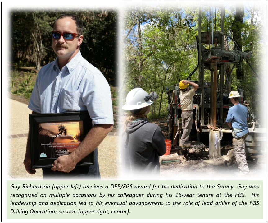
Guy Richardson, Engineering Specialist and lead driller of the FGS Drilling Operations team, passed away on June 11, 2022. For 16 years, Guy served as a dedicated employee at the FGS.
A pleasure to work with, Guy had a wonderful sense of humor, was an avid reader and had a fondness for animals and the environment. He was a friend to many, and all his colleagues will miss his expertise, kindness and sense of humor. “I’ve known Guy since he joined the survey. He had a quick and sometimes dry wit that made you think,” said Dave Paul. “Guy was a pleasure to work with in the field where he was in his element.”
Guy was not one to boast, but his numerous career accomplishments are noteworthy. His natural mechanical ability and love for the outdoors made him well suited for the complex, highly skilled job of lead driller. Guy was instrumental in many FGS projects that required drilling cores or installing monitor wells, including various cooperative projects with academia and local, state and federal government agencies.
Guy was recognized by his colleagues with accolades and awards, including an FGS Individual Extra Effort Award (2007) and an FGS Team Extra Effort Award (2015), for his commitment to excellence in public service.
|
 |
To celebrate Guy’s life, FGS dedicated a redbud tree in his memory on the east side of our main office building located at 3000 Commonwealth Blvd. As an honor to his legacy, an engraved placard was placed at the base of the tree so that employees and visitors will remember Guy as the invaluable public servant that he was.
Contact: Sarah Erb
Back to top
|

