|
Greetings, and welcome to the Spring Edition of FGS News and Research. In this issue, we explore radon, sinkhole warning signs, and changes in sea level. While attention is focused on coastlines across the state, much interest centers on the seafloor under Florida’s coastal waters. The coastal zone is the landward edge of the region of interest for the Florida Coastal Mapping Program. Learn more about the FCMaP mission and other initiatives that will lead to coastal mapping beneath the waves. Returning to the rocks we know and love, our Featured Formation of the Quarter is the Marianna Limestone, which is host to many karst features within the famous Florida Caverns State Park.
Service to geoscience professions is important. As part of my responsibilities as State Geologist, I serve on the Florida Board of Professional Geologists. Years ago, I also served as president of the Florida Association of Professional Geologists (FAPG). During that period, the FAPG became the Florida Section of the American Institute of Professional Geologists (AIPG). More recently, I was honored to be elected to the American Geosciences Institute (AGI) as a Member-at-Large on their Executive Committee. Why all this disclosure? Because I want you to know about the important work of AIPG and AGI, the free resources these nonprofit organizations offer, and ways you can support their efforts.
Finally, it is with a heavy heart that we say farewell to Charles Walter “Bud” Hendry Jr., who passed away on March 7, 2018. Bud worked at the FGS for 39 years and served as a passionate and wise leader as Florida’s State Geologist.
Sincerely,

Jonathan D. Arthur, Ph.D., P.G.
Director and State Geologist
Florida Geological Survey
Florida Department of Environmental Protection


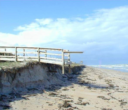
With its 1,350 miles of coastline, 4,500 square miles of bays and estuaries, and 6,700 square miles of coral reefs, bars, islands and low-lying topography, Florida is especially vulnerable to the effects of rising seas.
Water volume in the oceans change in relation to changes in the volume of continental ice, changes in surface water runoff, and groundwater seepage; however, volume also responds to ocean temperature – increased temperatures will increase the volume of water in the oceans. On the geological side of the equation, movement of tectonic plates that make up the Earth’s crust change the shape of ocean basins and therefore affect water levels in the basins. Related to moving crustal plates are isostatic effects, in which landmasses experience vertical movement in response to balancing unseen forces affecting the Earth’s crust.
We all know sea level changes, but how are the land levels changing? Florida’s geologic map helps answer the question. The map depicts rock and sediment units of similar age and character that occur along Florida’s land surface. These mapped units range in age from less than 18,000 years old to more than 40 million years old. The older rocks belong to the Eocene Avon Park Formation and occur at land surface in Citrus and Levy counties. This geologic unit contains marine fossils, indicating it was deposited when Florida was submerged beneath the ocean. In other parts of Florida, rocks of this age are buried by hundreds of feet of younger strata. Geologic evidence tells us that the rocks in Citrus and Levy counties were also once buried; however, erosion of this region exposed the Eocene rocks we see at land surface today – a reflection of relative uplift or lack of subsidence as compared to other parts of Florida.
There is more to the story when we fast forward to the more recent geologic past. Three geoscientists, Adams, Opdyke and Jaeger (2010), presented modeling results indicating that the natural dissolution of limestone and related rocks has resulted in a lowering of land surface that has been partially offset by isostatic uplift over the last 1.6 million years. Data reflecting modern times was collected on the Earth’s shape (geodetic data) by two researchers, Holdahl and Morrison in 1974. They reported that land surface elevations have been rising at a rate of +0.04 inches per year near Fort Myers while declining at a rate greater than -0.16 inches per year near Melbourne.
Global sea-level rise is well-studied and documented. In Florida, the rise ranges up to 0.15 inches per year according to the National Oceanic and Atmospheric Administration (NOAA) online sea-level tool. These rates reflect the cumulative effect of all the above factors relating to sea level. Vertical crustal movement has played a role, albeit minor, alongside the sea. DEP continues to help ensure collaboration among our coastal communities to help them address the increasingly complex effects of sea-level rise, including tidal “sunny day” flooding, habitat shifts, and erosion.
Resources:
Adams, P.N., Opdyke, N.D., and Jaeger, J.M., 2010, Isostatic uplift driven by karstification and sea-level oscillation; modeling landscape evolution in north Florida: Geology, v. 38, p. 531-534.
Holdahl, S.R. and Morrison, N.L., 1974, Regional investigations of vertical crustal movements in the U.S. using precise relevelings and mareography data: Tectonophysics, v. 23, p. 373-390.
Contact: Daniel C. Phelps, P.G. or
Dr. Jonathan D. Arthur, FGS Director and State Geologist
Back to top
|
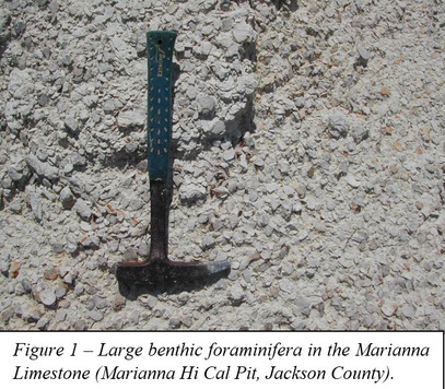
The name Marianna Limestone was first used by Matson and Clapp (1909) in their description of a soft, porous, light-gray to white limestone that occurs in western Florida. This limestone unit was identified by the abundant fossils it contains, which include larger benthic foraminifera (Figure 1) and a small, bivalve mollusk (Pecten poulsoni). The Marianna Limestone is generally described as a soft, pure, white, chalky, fossiliferous limestone with thin zones that contain a small percentage of glauconite, which is a greenish mineral of the mica group. The type area for the Marianna Limestone includes exposures just west of the Chipola River in Marianna (Jackson County).
|
The Marianna Limestone was deposited during the early Oligocene Epoch (approximately 33 million years ago), a finding based upon age-diagnostic fossils found in the unit. During this time, sea level was high enough that the entire Florida Platform was submerged. This environmental condition is reflected by the remains of countless marine organisms like foraminifera, echinoderms (sea biscuits and sand dollars) and mollusks that are preserved in the Marianna Limestone. Exceptional fossil specimens have been found in the Marianna Limestone. In 1926, the remains of a fossil fish were discovered just east of the Chipola River near Marianna. The specimen was sent to the American Museum of Natural History in New York, where it was identified as Lutianus avus, which is a fish belonging to the snapper family. At the time, it was the earliest known occurrence of this family of fish.
The Marianna Limestone is exposed in parts of Jackson and Holmes counties, but extends into the subsurface across Alabama and into Mississippi. In Florida, the Marianna Limestone attains a maximum thickness of approximately 300 feet. It is underlain by the upper Eocene Ocala Limestone and is overlain by upper Oligocene formations that are not well-defined. These formations have been referred to as the Chickasawhay formation, the Byram marl and the Suwannee limestone, but the defining character of these stratigraphic units has been the presence of indicator fossils. As outlined in previous FGS News and Research articles, a formation can be defined based upon its lithologic character only, not by the occurrence of index fossils. Since many of the limestone formations in Florida were originally defined based upon their fossil assemblage, the lithostratigraphy of these units needs to be refined.
|
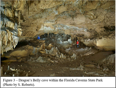
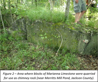
The Marianna Limestone is locally referred to as “chimney rock.” It has been used as a building stone since the 1800s. The soft, massive limestone was extracted in large blocks and shaped using hand saws into facing stones (Figure 2). These stones were used on the exterior of homes and particularly on chimneys, where the exterior would eventually case-harden after exposure to the elements. The Marianna Limestone is susceptible to being dissolved by rainwater and is highly karstic where it is exposed or near the surface. The famous Florida Caverns State Park in Marianna contains a number of caves (Figure 3) and other karst features that are developed within the Marianna Limestone. This is the only place in Florida open to the public where you can tour a cave and see the Marianna Limestone from inside the formation!
Contact: Harley Means, P.G. Administrator
|
In the wake of the Florida LiDAR Assessment, we learned that the benefit/cost ratio for statewide, seamless LiDAR is 3.7. This means that for every dollar invested in LiDAR, the state would realize a return of $3.7. Upscaling this to a more practical level, implementing a statewide LiDAR collection program with repeated collection every two to three years would realize annual net benefits exceeding $21 million per year, an estimate that is indicated by experts to be a minimum amount. Based in part on results of the Florida LiDAR Assessment, the Governor and Florida Legislature have allocated $15 million to the Division of Emergency Management. The division will embark on statewide terrestrial LiDAR data collection through competitive procurement to produce a “complete and accurate 3D map of the entire state for use in emergency management, infrastructure planning, agriculture and forestry, among other purposes. The 3D map must meet the requirements of all state agencies.”
The interest in LiDAR, however, does not stop at the shoreline. Dewberry, author of the Assessment, also reports a 5.1 benefit/cost ratio for statewide collection of topobathymetric LiDAR within Florida’s shallow coastal waters. The annual net benefits are $28 million, $7 million above the terrestrial LiDAR benefit yearly amount. From a geoscience perspective, high-resolution bathymetry would vastly improve our understanding of landforms that formed during sea-level low-stands, offshore geology, coral ecosystems, and distribution of mineral sands and springs.
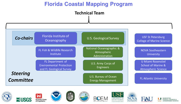
Florida’s coastal zone is the landward edge of the region of interest for the Florida Coastal Mapping Program (FCMaP). The FCMaP mission involves coordination between federal and state partners, non-government organizations, academia and other stakeholders to develop a more comprehensive understanding of the Florida coastal seafloor out to the edge of the continental shelf. The FCMaP vision is to achieve an “accessible, high-resolution seafloor map of Florida’s coastal waters to support infrastructure, benthic habitat mapping, restoration projects, resource management, emergency response, and coastal resiliency for the citizens of Florida.”
The FCMaP is led by a steering committee alongside representatives from academia (see table above). A group of data stewards representing multiple agencies also support the effort. At a workshop in January 2018, discussions focused on data needs between zero and 20 meter depths, and from 20 meters to the shelf edge. Different technologies would be employed for bathymetric mapping, ranging from LiDAR in water depths generally less than 10 meters, to multibeam, sidescan and sub-bottom systems in deeper waters.
Other important projects to follow if you are interested in sea-floor bathymetry are 3D Nation, led by NOAA and USGS, and SEABED 2030, a global effort led by General Bathymetric Chart of the Oceans, which operates under the auspices of UNESCO, and the Nippon Foundation. The 3D Nation study seeks to refresh the 2012 National Enhanced Elevation Assessment and better understand 3D data requirements and benefits of the nation, including how they dovetail in the coastal zone. SEABED 2030 seeks to collaboratively map the entire ocean floor by 2030.
Contact:
Dr. Jonathan D. Arthur, FGS Director and State Geologist
Back to top
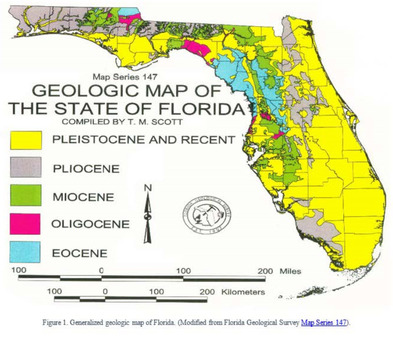
Radon (Rn) is a radioactive, colorless, odorless gas resulting from the radioactive decay (the spontaneous transformation of one element into another) of radium (Ra), which is a byproduct of the radioactive decay of uranium (U). These elements are naturally present in soils, rocks, and water around us. Although all rocks naturally contain some uranium, most contain only a small amount (between 1 and 3 parts per million). Geologic processes can naturally concentrate these elements in some areas, leading to variable radon concentrations in different geologic units and soil types. In Florida, radon is generally associated with sediments of Miocene and Pliocene age (Figure 1). These sediments have variable concentrations of phosphate pebbles and sand, which typically contain higher concentrations of these radioactive elements (U, Ra, Rn). Radon also can be associated with Pleistocene and Recent heavy mineral sands (yellow on the map). These unique sands are the small black grains often seen along the shoreline of Florida’s white-sand beaches. From a geologic perspective, radon is less likely to emit from the older Eocene and Oligocene limestones, but it can happen.
|
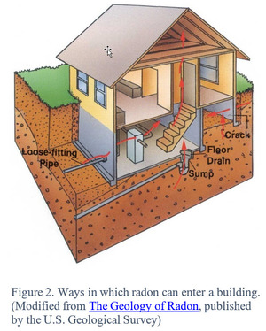
Because radon is a gas, it can escape the soil more easily than uranium and radium (which are solids). The ability of radon to escape the soil depends on many factors such as the soil moisture, permeability, mineralogy, and trace mineral concentrations in the rocks and soil. While most radon from the ground escapes into the atmosphere, some radon can leak into buildings through foundation cracks, plumbing and electrical penetrations in the foundation, and cracks in floors and exterior walls (Figure 2). Earthen construction material also can allow radon to enter buildings.
You might ask yourself if you should be concerned about radon in your house or office. Unfortunately, the only way to know if a building has high radon is to test it. Based on the collected data, one out of five homes tested in Florida has elevated radon levels. The U.S. Environmental Protection Agency has set an action level of 4 picocuries per liter of air (pCi/L) for homes and buildings. By comparison, the World Health Organization recommended in 2017 that this threshold should be less than 2.7 pCi/L. For more information about how to test your home or building, visit the Florida Department of Health Radon website, which is an excellent resource for finding out more about the health effects of radon, how to test your home for radon, and how to find certified radon measurement and mitigation businesses and individuals.
Contact: Rick Green, Professional Geologist III
Back to top
|
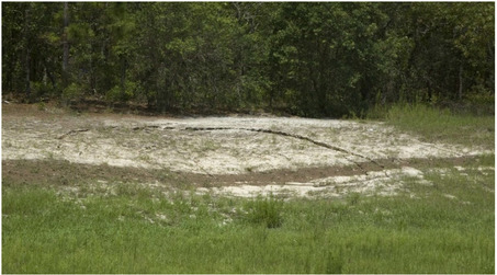
That low spot in the lawn isn’t necessarily a sign of sinkhole activity. It may just be a depression from a rotting tree stump, or from fill that wasn't fully compacted during construction. Sometimes a hole in the yard is the entrance to some small creature’s burrow. However, in Florida, that depression or hole can sometimes be evidence that a sinkhole is forming.
Sinkholes can appear without warning. On the other hand, signs of an impending sinkhole may appear. In addition to land-surface depressions, you may observe soft ground or wilting vegetation, or the appearance of cracks in driveways, sidewalks, curbs, streets, and near the windows and the doors of buildings. If you do see these cracks, act prudently but do not panic as the cracks may only reflect the settling or compaction of sediment. Other subtle warning signs can be sudden difficulty opening doors and windows, small cracks in floors or walls, and/or water ponding where it didn’t previously.
Sinkholes have the potential to be dangerous when they form in your yard or on your street, or when they affect multiple properties. They can damage buildings and roads, and disrupt utilities (e.g., water, power, gas and sewer lines). Even a small hole can be cause for concern and could grow larger. Picture the center of that hole as if it were the bull's-eye of an archery target. If you see curving cracks, often multiple curving cracks, ringing that hole like rings on a target, stay outside of and well back of those cracks. They are surface evidence of what is occurring under the ground, and they could be the outline of an area yet to collapse.
|
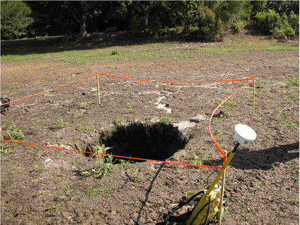
Sinkholes often appear in multiples. If you think you see one, look for evidence of others. If you find suspicious areas near a formed sinkhole, do not go between them as they may be in the process of growing together into a larger sinkhole.
If you suspect that a sinkhole is beginning to form, keep people, vehicles, pets and farm animals away from it. If it is affecting your house or building, especially if the structure shakes, cracks appear suddenly, or you hear ominous noises (e.g., breaking window glass), leave the premises and call 911. If the feature is affecting sidewalks, roadways or utility easements, call whomever is responsible for their upkeep (e.g., county or city public works). Tell them what is occurring and ask them to send out an inspector. Above all, use common sense. If you sense anything may be wrong, take action.
For more information about sinkholes in Florida, please visit the Florida Geological Survey’s frequently asked questions webpage.
To speak with a licensed professional geologist about sinkholes, call the Florida Geological Survey’s dedicated Sinkhole Group Helpline* at 850-245-2118.
*Note: Geologists of the Florida Geological Survey do not perform site inspections.
Contact: Dan Phelps, Professional Geologist II
Clint Kromhout, Professional Geologist Administrator
|
Did you know that through a collaboration between American Institute of Professional Geologists (AIPG) and American Geosciences Institute (AGI), several high-quality and free online training programs are available to you? Thanks to the AGI Geoscience Online Learning Initiative, you can take a deeper dive on coastal erosion, contaminant transport, geoethics, critical minerals, geoscience writing, water resources, and more by hearing from national experts! Many of these courses offer continuing education units (CEUs). While CEUs are not presently required for Florida PGs, implementing such a program remains a goal of the Florida section of AIPG - the Florida Association of Professional Geologists (FAPG). The Florida Board of Professional Geologists has had discussions supportive of this concept as well.
The FAPG protects, enhances and promotes the Professional Geologist profession in Florida. They work throughout the year to provide professional education and networking opportunities, including the Fourth Annual Winter Water Seminar held recently in Tallahassee. In collaboration with the Florida Engineering Society, the seminar brought together more than 150 geoscience and engineering professionals from across the state to discuss water resources, potable reuse, and waste management issues and solutions. The FAPG also supports student chapters to foster development of young geoscientists, and works to keep all members informed on legislative issues related to the profession. At a national level, AIPG offers services and resources such as The Professional Geologist, a job board, networking and educational opportunities, awards, field trips, and professional recognition through the CPG program.
AGI is the “society of societies” that brought you the award-winning series Faces of Earth (now on YouTube), the ever-useful Glossary of Geology, the engaging Earth magazine, worldwide implementation of Earth Science Week, and GeoRef – the pipeline to nearly 4 million geoscience papers and reports from across the globe. The AGI also monitors national geoscience policy, critical issues, workforce trends, legislative resources and more. Do you know a teacher? Point them to the vast geoscience educational resources. There are 54 member societies of AGI, including AIPG, the Geological Society of America, the American Geophysical Union, and the Association of American Petroleum Geologists. Founded in 1948 under a directive from the National Academy of Sciences, AGI represents a quarter-of-a-million geoscientists. AGI makes the geosciences bigger than the sum of its parts.
Contact: Dr. Jonathan D. Arthur, Director and State Geologist
|
Charles Walter "Bud" Hendry Jr., who served as State Geologist and FGS ‘Chief’ from 1971 to 1988, passed away peacefully on March 7, 2018. Bud was an Honorary Member of the Association of American State Geologists and had the distinction of receiving the first Master of Science degree in geology from Florida State University.
Born in 1925, Bud began his career at the FGS in 1949 as a draftsman’s assistant. During his 39-year tenure at the FGS, he held positions including Stratigrapher, Director of Water Resource Investigations, and Assistant State Geologist. He contributed to 19 Survey publications and, in the early years of geoscience informing policy, was lead author of the 1957 “FGS Information Circular 10: Interim Report on the Progress of an Inventory of Artesian Wells in Florida, Leading to the Enforcement of Sections 370.051-370.054, Florida Statutes.” From a Tallahassee perspective, Florida geoscientists are all familiar with Bulletin 47 (1966), Geology and Ground-Water Resources of Leon County, Florida by C.W. Hendry Jr. and C.R. Sproul. Perhaps the most notable of Bud’s contributions, however, was “Bulletin 31 (Revised, 1977), Springs of Florida,” a 461-page document he co-authored.
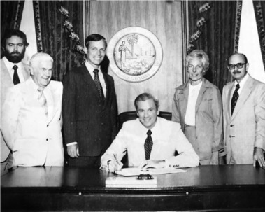
Under Bud’s leadership as State Geologist, the FGS created the state’s mine reclamation regulatory section, and expanded Florida’s oil and gas regulatory program with field offices in Jay and Fort Myers. The photo shows Bud (far right) with Florida Governor Reubin Askew at the signing of the 1978 Phosphate Land Reclamation Act. Bud also recognized the need for geology by land-use planners and implemented the environmental geology mapping series.
Director Jon Arthur remembered Bud fondly when he learned of his passing: “During my early days as an OPS geologist at FGS, I had the pleasure of knowing Bud and have always enjoyed my conversations with him over the years. Bud was a personable, passionate and wise leader, quick to laugh and equally quick to get to business,” Jon recalled. “Today’s leaders serve in the shadows of giants. Bud was indeed a giant, helping to build and sustain the FGS as a fine institution.”
Contact: Dr. Jonathan D. Arthur, FGS Director and State Geologist
|
|