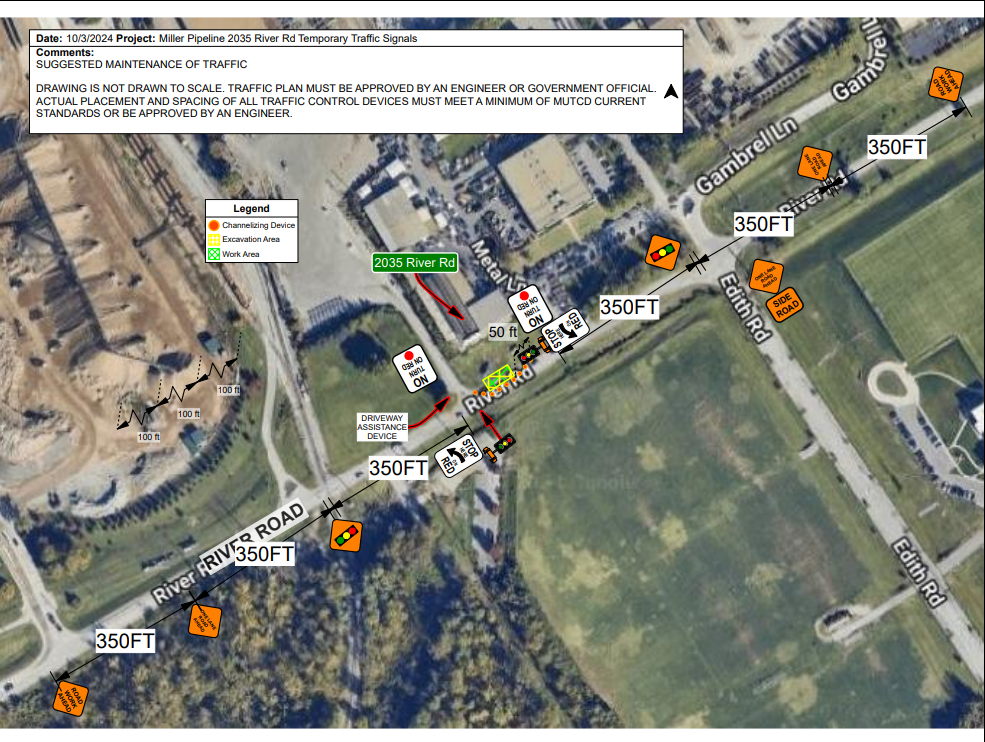
 A small section of East River Road between Edith Rd. & Frankfort Ave. will be reduced to one-lane as part of the East River Rd. Widening Project. The temporary lane reduction is due to utility work and is scheduled to take place from Tuesday, October 15 to Friday, October 25. Temporary traffic signals will be in place to ensure safe traffic movement. Expect delays during this time frame and plan your commute accordingly.


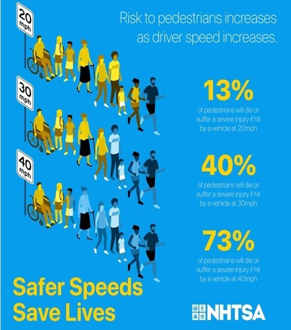 In 2020 October was designated as "National Pedestrian Safety Month." Pedestrian deaths in the U.S. reached a 40-year high in 2023, spurred in part by inadequate infrastructure, such as missing sidewalks or lighting, the rise in popularity of SUVs and pick-up trucks, which tend to strike a person in the head, neck, and chest area, and wide, high-speed arterial roadways separating residential areas from commercial uses.
In a crash involving a vehicle and a pedestrian, the pedestrian is far more likely to be killed or injured. Here are a few safety tips for motorists.
-
Slow down. Vehicle speed and weight greatly determine injury severity, or the level of blunt force trauma a person must endure. Obey the speed limit.
-
Use extra caution when driving at night. National and local statistics show approximately 75% of pedestrian fatalities occur during non-daylight hours.
-
Don't run. Stop and render aid if you hit someone. Call 911 immediately. National and local statistics show approximately 25% of pedestrian fatalities are hit-and-run. Visit StopTheBleed.org to learn techniques to reduce blood loss after injury.
Earlier this year, Louisville Metro Public Works and the Kentucky Transportation Cabinet (KYTC) released a new report on pedestrian safety in Louisville. Prepared by Palmer Engineering and HDR, the report finds that fatal and suspected serious injury crashes have increased over the past decade, mirroring a national trend in the U.S.
The report includes four lists of intersections recommended for pedestrian safety improvements. Of the 176 total unique intersections, 85% are included in Louisville's High Injury Network. A High Injury Network is a data-driven approach which identifies non-interstate roadway segments that account for a disproportionate amount of a community's fatal and serious injury crashes. The High Injury Network allows communities to focus limited resources on improving safety along high priority corridors.
Join us for the most magical pumpkin event of the season. 🎃⚡🔮 Tickets are on sale NOW! 🎟️ https://tinyurl.com/JOLS24 Step inside the majestic world of the Louisville Jack O'Lantern Spectacular, presented by Thorntons. ✨October 1 - November 2, 2024 The trail awaits... 👻
You are invited to attend a review for a MODIFIED CONDITIONAL USE PERMIT for a golf driving range.
Subject Property: 3742 River Road
Case Number: 24-MCUP-0015
Case Manager: Ethan Lett ( ethan.lett@louisvilleky.gov )
Meeting Type: Board of Zoning Adjustment
Meeting Date: Monday, October 21, 2024
Time: Meeting will begin at 1:00pm and continue until all cases are heard
Location: 514 W Liberty Street, 40202 (Old Jail Building)
You may participate online, and view case material by visiting: https://louisvilleky.gov/government/office-planning/upcoming-public-meetings
For meeting agenda and staff report, please visit:
https://louisvilleky.primegov.com/public/portal
More information is available in person at:
Louisville Metro Office of Planning (Hours: 8:00 AM to 5:00 PM)
444 S. 5th Street, 3rd Floor, Louisville, KY 40202
(502) 574-6230
If you wish to submit comments in writing on this case, please submit to the case manager by 9:00 A.M. Friday, October 18, 2024. If you would like to provide verbal testimony, please attend the meeting, or participate online. Additional information or written comments submitted after applicable deadlines must be approved by the Board at the meeting; the Board may choose to not accept such information or comments.
Persons who desire special accommodations should contact the Planning Commission office at (502) 574-6230 at least one week prior to this meeting. TDD users please use the Relay Service, 1-800-648-6056.
| JEFFERSON COUNTY |
|
| I-64 / I-71 / I-265 (I-MoveKY) |
Find the latest project updates here: https://i-moveky.com/.
|
| Sherman Minton Bridge |
I-64 & U.S. 150 over the Ohio River between Louisville, KY, and New Albany, IN.
Find the latest project updates here: https://shermanmintonrenewal.com/.
|
I-65 South
(John F. Kennedy Memorial Bridge)
|
Traffic Impacts: Closure of the left two lanes and traffic shifts.
Date/Time: The left two lanes will remain closed beginning Friday, Oct. 11 at 5 p.m. through Tuesday, Dec. 24, at 6 a.m.
Project Limits: John F. Kennedy Memorial Bridge, which carries I-65 South over the Ohio River in Louisville.
Type of Work: Steel bridge repairs.
Other Details: This project is expected to be completed by May 2025.
*Project Press Release
|
| I-64 East & West |
Traffic Impacts: Lane closures, traffic shifts, and rolling roadblocks are possible.
Date/Time: Daily/Nightly.
Project Limits: Near mile marker 19, extending to the Shelby County line.
Type of Work: Roadway rehabilitation project in Jefferson and Shelby Counties.
Other Details: *Project press release. This project is set to be completed by the fall of 2024.
|
| I-264 East & West (Watterson Expressway/Georgia Davis Powers Expressway) |
Traffic Impacts: Intermittent lane closures are possible.
Date/Time: Nightly – 8 p.m. to 5 a.m., including weekends.
Project Limits: I-264 from the I-64 interchange at mile marker 0, extending east to I-65 at mile point 12.7.
Type of Work: Pavement striping and pavement marker installation.
|
| I-265 (Gene Snyder Freeway) |
Traffic Impacts: Lane and shoulder closures are possible.
Date/Time: Daily – 9 a.m. to 3 p.m.
Project Limits: The bridge over KY 61 (Preston Highway) at mile point 11.83.
Type of Work: Bridge cleaning/painting and joint repairs.
Other Details: Motorists should use caution when traveling through the work zone.
|
| KY 329 (Covered Bridge Road) |
Traffic Impacts: Lane closures are possible.
Date/Time: Nightly – 6 p.m. to 6 a.m.
Project Limits: KY 329 (Covered Bridge Road) from U.S. 42 in Jefferson County extending to KY 1817 in Oldham County.
Type of Work: Asphalt resurfacing.
Other Details: Motorists will be directed through the work zone via flagging operations. Drivers should use caution and expect delays while traveling through the work zone.
|
|
KY 841 North (Gene Snyder Freeway) and Indiana 265 East at
East End Tunnel
|
Traffic Impacts: Closures of the East End Tunnel.
Date/Time:
- KY 841 North (Gene Snyder Freeway) will be closed nightly from 7 p.m. Monday, Oct. 14, through 6 a.m. Wednesday, Oct. 16. KY 841 North will be closed beyond Exit 37/Prospect (U.S. 42), limiting access to the East End Tunnel/Lewis and Clark Bridge to Jeffersonville, Indiana. The suggested detour is to continue south on U.S. 42 to I-264 East, then take I-71 South to I-65 North to the Abraham Lincoln Bridge.
- Indiana 265 East will be closed nightly from 7 p.m. Wednesday, Oct. 16, through 6 a.m. Friday, Oct. 18. IN 265 East will be closed beyond Exit 11/International Drive in Jeffersonville, Indiana, limiting access to the East End Tunnel/Lewis and Clark Bridge to Louisville, Kentucky. The suggested detour is to head back to IN 265 West and take Exit 7B to I-65 South to the John F. Kennedy Memorial Bridge.
Project Limits: The East End Tunnel (KY 841 North (Gene Snyder Freeway) and Indiana 265 East).
Type of Work: The closures are necessary for contract crews to perform the routine inspection of the tunnel.
Other Details: Motorists should follow posted detours and use WAZE to navigate around the closure.
|
| U.S. 31E (Bardstown Road) |
Traffic Impacts: Lane closures are possible.
Date/Time: Wednesday, Oct. 16, from 6:30 p.m. to 11:30 p.m.
Project Limits: Hikes Lane (mile point 10.970) to Tyler Lane (mile point 12.593) - West Buechel, Bashford Manor, and Upper Highlands neighborhoods
Type of Work: Traffic Signal Controller equipment upgrades.
Other Details: This work will require signal technicians to place each intersection on an all-red flash operation for a short duration (10 minutes or less per intersection) while the equipment is installed. Please remember traffic signals operating on an all-red flash pattern shall be treated as all-way stop conditions. Technicians will work on up to three intersections concurrently to expedite the conversion process while limiting the overall impacts on the corridor. New coordinated signal timing patterns will also be deployed along the corridor in an effort to improve safety and reduce congestion. Motorists should use caution when traveling through the work zone.
|
| KY 22 (Brownsboro Road)/Springcrest Drive Intersection |
Project Limits: KY 22 (Brownsboro Road) between Cliffwynde Trce and Pine Hurst Lane.
Type of Work: The project included the reconstruction of two 11-foot travel lanes and the addition of a dedicated left-turn lane. A new six-foot sidewalk was also constructed along the north side of KY 22, extending from Cliffwynde Trce to Brownhurst Cove Road.
Other Details: While traffic has resumed, work to complete some final project details is still underway, and intermittent lane closures remain possible.
|
| KY 864 (Logan Street/Shelby Street) |
Traffic Impacts: Sidewalks and lane closures are possible.
Date/Time: Daily.
Project Limits: Between Goss Avenue and East Gray Street.
Type of Work: One-way to two-way conversion.
Other Details: Work is underway ahead of asphalt resurfacing and the two-way conversion of the roadway.
*https://transportation.ky.gov/DistrictFive/Pages/Jefferson-County-KY-864-Shelby-Street-and-Logan-Street-One-way-to-Two-way-Conversion.aspx
|
| KY 1065 (Outer Loop) |
Traffic Impacts: Lane closures and traffic shifts are possible. *Concrete work within the intersection of KY 1065 (Outer Loop) and Shepherdsville Road, which will require additional lane closures and traffic shifts.
Date/Time: Daily/nightly.
Project Limits: From mile point 5.470 (near Briarcliff Road) to mile point 7.717 (near Donegal Drive)
Type of Work: Concrete rehabilitation project
Other Details: Motorists should obey restrictions and use caution when traveling through the work zone.
|
| KY 1447 (Westport Road) |
Traffic Impacts: Nightly lane closures.
Date/Time: Nightly from 7 p.m. to 6 a.m.
Project Limits: KY 1447 (Westport Road) from KY 1747 (Hurstbourne Parkway) to Freys Hill Road.
Type of Work: Asphalt resurfacing.
Other Details: Asphalt resurfacing has been completed, with final punch list items remaining.
|
| KY 1631 (Crittenden Drive) |
Traffic Impacts: Lane closures with flagging operations.
Date/Time: Nightly from 7 p.m. to 6 a.m. beginning Monday, Oct. 7.
Project Limits: Beginning at the airport where state maintenance begins (just north of Martha Maloney Drive) extending north to the U.S. 60A (Eastern Parkway) intersection.
Type of Work: Base failure repairs and asphalt resurfacing.
Other Details: This project is set to be completed by the fall of 2024.
|
| KY 1819 (Billtown Road) |
Traffic Impacts: Lane closures and delays are possible.
Date/Time: Daily – 9 a.m. to 4 p.m.
Project Limits: Three sections of KY 1819/Billtown Road (Easum Road through Mary Dell Lane, Michael Edward Drive through Fairground Road, and Shady Acres Lane through Colonnades Place).
Type of Work: Reconstruction of KY 1819 (Billtown Road) from north of Colonnades Place to south of Easum Road with new traffic signals, signal optimization, turn lanes, storage lanes, etc. (varying by intersection based on existing conditions and future traffic projections for the location).
Other Details: The project is expected to be completed by the summer of 2025.
*https://transportation.ky.gov/DistrictFive/Pages/KY-1819-Billtown-Road-Reconstruction---Project-05-8203.aspx
|
| KY 1931 (Manslick Road) |
Traffic Impacts: Lane closures, traffic shifts, and delays are possible.
Date/Time: Daily from 7 a.m. to 4 p.m. beginning Monday, Oct. 1, through Friday, Oct. 4.
Project Limits: From mile point 6.430 (near Stephan Lane) to just south of the I-264 overpass at mile point 7.457.
Type of Work: Asphalt resurfacing.
Other Details: Asphalt resurfacing has been completed, with final punch list items remaining.
|
| KY 3084 (Old Henry Road) |
Traffic Impacts: Intermittent lane closures are possible.
Date/Time: Daily/nightly.
Project Limits: From Twin Creek Road to Woodmont Branch.
Type of Work: Major roadway construction.
Other Details: *The new route connecting KY 3084 (Old Henry Road) and KY 362 (Ash Avenue) is now open. Work to complete some final details of the project is still underway, and intermittent lane closures are possible. The project began in October 2022 and was completed ahead of schedule.
*This work is part of the KY 3084/KY 362 construction project.
|
| Jefferson County (Various Locations) |
Traffic Impacts: Lane closures and delays are possible as a part of a mobile operation.
Date/Time: Nightly – 7 p.m. to 6 a.m.
Type of Work: Pavement marker (reflector) maintenance and paint striping.
Other Details: Motorists should provide plenty of space to crews displaying "WET PAINT" signage and be observant of slowed vehicles while traveling through the work zone.
|
| |
|
| BULLITT COUNTY |
|
| KY 44 (Old Mill Road) |
Traffic Impacts: Lane closures, traffic shifts, and delays are possible.
Date/Time: Daily/nightly.
Project Limits: From the I-65 ramps at mile point 13.039 in Shepherdsville to just east of Snapp Street at mile point 22.991 in Mt. Washington.
Type of Work: Asphalt resurfacing.
Other Details: Asphalt resurfacing has been completed, with final punch list items remaining.
|
| KY 61 (Preston Highway) |
Traffic Impacts: Northbound and southbound left lane closures and traffic shifts. Delays are possible.
Date/Time: Monday, Oct. 14, from 8 a.m. to midnight.
Project Limits: From Tanyard Springs Blvd. (mile point 20.769) to Ky 1116/Zoneton Road (mile point 21.022)
Type of Work: Roadway repair.
Other Details: Motorists should be observant of all road work signage and provide plenty of space for slowed vehicles while moving through the work zone.
|
| KY 1494 (Beech Grove Road) |
Traffic Impacts: Lane closures, traffic shifts, and delays are possible.
Date/Time: Daily/nightly.
Project Limits: From Reichmuth Lane (mile point 6.675) extending north to just south of Old Beech Grove Road (mile point 7.467)
Type of Work: Asphalt resurfacing.
Other Details: Motorists should be observant of all road work signage and provide plenty of space for slowed vehicles while moving through the work zone.
|
| I-65 North & South |
Traffic Impacts: Changing traffic patterns, lane shifts, and closures possible.
Date/Time: Daily/nightly.
Project Limits: From mile point 104.7 to mile point 110.7 (Bullitt and Hardin Counties).
Type of Work: Full concrete pavement removal and asphalt pavement replacement. Other improvements to the corridor include bridge repairs, subgrade repairs, and guardrail repairs/installation.
Other Details: The project is expected to be completed by the fall of 2024: https://transportation.ky.gov/DistrictFive/Pages/Bullitt-County-I65-Roadway-Rehabilitation.aspx
|
| I-65 North & South |
Traffic Impacts: Lane closures and delays are possible as a part of a mobile operation.
Date/Time: Nightly – 8 p.m. to 5 a.m.
Type of Work: Pavement marker (reflector) maintenance.
Other Details: Motorists should be observant of all road work signage and provide plenty of space for slowed vehicles while moving through the work zone.
|
I-65 North & South
*Various Exit Ramps |
Traffic Impacts: Intermittent lane and ramp closures.
Date/Time: Nightly – 8 p.m. to 6 a.m. | Daily – 9 a.m. to 3 p.m.
Project Limits: Various interchange Exit ramps on I-65.
Type of Work: Upgrade and install wrong-way pavement markings and signs.
Other Details: The Highway Safety Improvement Project will install and enhance wrong-way signs and pavement markings on interstate exit ramps to discourage wrong-way driving. Motorists should reduce speeds and obey traffic control while workers are present. This project is set to be completed by the fall of 2025.
|
| KY 480 (Cedar Grove Road) |
Traffic Impacts: As construction progresses, changing traffic patterns, lane shifts, and closures are possible.
Date/Time: Daily/nightly.
Project Limits: On KY 480 (between I-65) from mile point 0.6 to mile point 1.4.
Type of Work: Construction of a Double Crossover Diamond interchange.
Other Details: The project is expected to be completed by fall 2025.
https://transportation.ky.gov/DistrictFive/Pages/I-65-at-KY-480-interchange-improvements-in-Bullitt-County.aspx
|
| |
|
| FRANKLIN COUNTY |
|
U.S. 60X
(Singing Bridge) |
Traffic Impacts: Closure.
Other Details: As a precaution to ensure the safety of motorists and pedestrians, the Singing Bridge will be closed until further notice.
The recent routine inspection of the 130-year-old bridge found significant structural deterioration that affects the bridge's weight-carrying capacity, prompting state engineers to close the bridge immediately to vehicles and pedestrians.
Further assessments and evaluations are needed to determine the next steps. There is no estimated timeframe for the bridge's reopening.
*Press release.
|
| I-64 East & West |
Traffic Impacts: Closure of the right shoulder near both eastbound and westbound bridges.
Date/Time: Daily.
Project Limits: I-64 Bridges over the Kentucky River and KY 1659.
Type of Work: Preventative maintenance project for the I-64 Bridges over the Kentucky River in Franklin County.
Other Details: The project is expected to be completed by the fall of 2024.
*Project press release.
|
| I-64/U.S. 127 Interchange |
Traffic Impacts: Lane closures on U.S. 127 near the I-64 interchange. Two 10-foot travel lanes will be maintained in each direction, with nightly lane reductions possible.
Date/Time: Nightly.
Project Limits: I-64/U.S. 127 interchange.
Type of Work: The realigning of the I-64 West off-ramp to U.S. 127 North and the I-64 West on-ramp from U.S. 127. Other improvements include the installation of a new signalized intersection on U.S. 127 to provide access to development entrances, which will be activated following project completion. Additionally, the intersection of Westridge Drive and Leonardwood Drive will be reconstructed to accommodate dual left turns onto Westridge Drive from U.S. 127.
Other Details: *Project press release.
The project is expected to be completed by the summer of 2025.
*Starting at 9 p.m. on Friday, Oct. 11, the existing off-ramp from I-64 West to U.S. 127 North (Lawrenceburg Road) at Exit 53B in Franklin County will be permanently closed. The newly realigned off-ramp is expected to open by 5 a.m. on Monday, Oct. 14.
|
| KY 420 (Capital Avenue/Todd Street) |
Traffic Impacts: Sidewalk closure.
Date/Time: Daily beginning Monday, Sept. 16.
Type of Work: ADA sidewalk ramp improvements in conjunction with the asphalt resurfacing project on KY 420 (Old Lawrenceburg Road) from mile point 2.145 at KY 676 extending north to East 2nd Street at mile point 4.122.
Other Details: The sidewalk closures will be limited to one side at a time.
|
| KY 420 (Capital Avenue) |
Traffic Impacts: New traffic control measures of the KY 420 (Capital Avenue) and Todd Street intersection to an all-way stop condition.
Date/Time: Wednesday, Oct. 16.
Project Limits: The intersection of KY 420 (Capital Avenue) and Todd Street.
Type of Work: Implementation of all-way stop.
Other Details: KYTC crews will install signage, pavement markings and flexible delineators at the intersection as part of this change. "New Traffic Pattern Ahead" and "Stop Ahead" signs will also be placed to alert drivers of the stop condition. Motorists should heed signage, use caution and be prepared to stop.
|
| U.S. 421 (Bald Knob Road) |
Traffic Impacts: Lane closures and delays are possible.
Date/Time: Daily.
Project Limits: North of Clifty Drive at mile point 5.315 to Dry Ridge Road at mile point 11.132.
Type of Work: Improvements to the asphalt pavement, shoulder repairs, guardrail repairs/installations, and the construction of a retaining wall at mile point 9.46 (adjacent to Stoney Creek) for slope stabilization.
Other Details: Alternating one-way traffic will be maintained through project completion, and motorists will be directed through the work zone via temporary signals.
*A 9-foot-wide lane will be maintained for traffic through project completion, scheduled for fall 2024.*
|
| |
|
| HENRY COUNTY |
|
| I-71 North & South |
Traffic Impacts: Lane closures and delays are possible as a part of a mobile operation.
Date/Time: Nightly – 8 p.m. to 5 a.m.
Type of Work: Pavement marker (reflector) maintenance.
Other Details: Motorists should be observant of all road work signage and provide plenty of space for slowed vehicles while moving through the work zone.
|
| KY 146 (La Grange Road) |
Traffic Impacts: Lane closures and lane shifts are possible.
Date/Time: Daily/Nightly.
Project Limits: From mile point 2.82 to mile point 2.92 (at Little Kentucky River Bridge).
Type of Work: Major realigning and widening of the roadway, with bridge latex overlay work taking place for the next month.
Other Details: Motorists are directed through the work zone via temporary signals. This project is expected to be completed in the fall of 2024. Final surfacing is set to begin soon.
*https://transportation.ky.gov/DistrictFive/Pages/Henry-County-KY-146-Realignment-and-Widening-Project-05-80260.aspx.
|
| |
|
| OLDHAM COUNTY |
|
| I-71 North & South |
Traffic Impacts: Lane closures, traffic shifts, and delays are possible.
Date/Time: Daily/nightly, including weekends.
Project Limits: Between mile marker 18 (near KY 393) and mile marker 22 (near South First Avenue).
Type of Work: The I-71 rehabilitation project includes milling and removing the existing asphalt pavement and replacing it with new pavement. Other remaining improvements to the corridor include guardrail repairs/installations.
Other Details: Motorists should heed restrictions, proceed cautiously through the work zone, or seek an alternate route. The project is expected to be completed by the fall of 2024. More details here.
|
| I-71 North & South |
Traffic Impacts: Lane closures and delays are possible as a part of a mobile operation.
Date/Time: Nightly – 8 p.m. to 5 a.m.
Type of Work: Pavement marker (reflector) maintenance.
Other Details: Motorists should be observant of all road work signage and provide plenty of space for slowed vehicles while moving through the work zone.
|
| KY 329 |
Traffic Impacts: Lane closures, traffic shifts, and traffic delays are possible as construction progresses.
Date/Time: Daily/nightly.
Project Limits: KY 329 and KY 329 bypass (Veterans Memorial Parkway) intersection, just south of Interstate 71.
Type of Work: Major realigning and widening of the roadway.
Other Details: The project is expected to be completed in the spring of 2025.
|
| KY 3084 (Old Henry Road) |
Traffic Impacts: Lane closures are possible.
Date/Time: Daily/nightly.
Project Limits: From Twin Creek Road to Woodmont Branch.
Type of Work: Major roadway construction.
Other Details: *The new route connecting KY 3084 (Old Henry Road) and KY 362 (Ash Avenue) is now open. Work to complete some final details of the project is still underway, and intermittent lane closures are possible. The project began in October 2022 and was completed ahead of schedule.
*This work is part of the KY 3084/KY 362 construction project.
|
| |
|
| SHELBY COUNTY |
|
| I-64 East and West |
Traffic Impacts: Lane closures, traffic shifts, and rolling roadblocks are possible.
Date/Time: Daily/Nighty.
Project Limits: From mile points 19.44 and 27.88.
Type of Work: Roadway rehabilitation project in Jefferson and Shelby Counties.
Other Details: *Project press release. This project is set to be completed by the fall of 2024.
|
| U.S. 60 (Midland Trail) |
Traffic Impacts: Lane closures, traffic shifts, and delays are possible.
Date/Time: Daily/nightly.
Project Limits: U.S. 60 (Midland Trail) from mile point 8.386 (near Haven Hill Road) extending east to KY 53 at mile point 9.712.
Type of Work: Asphalt resurfacing.
Other Details: Motorists will be directed through the work zone via flagging operations. The expected completion date for this project is set for the fall of 2024.
|
| KY 12 (Bagdad Road) |
Traffic Impacts: Closure.
Date/Time: Beginning Friday, Oct. 11, requiring a full 30-day closure of the bridge.
Project Limits: Bridge over the RJ Corman Railroad at mile point 5.83 on KY 12 (Bagdad Road) near the KY 1005 (Vigo Road) intersection
Type of Work: Bridge replacement.
Other Details: Motorists should follow posted detours around the affected area. This project is set to be completed by the fall of 2024.
*Project press release.
|
| |
|
| SPENCER COUNTY |
|
| KY 248 (Briar Ridge Road) |
Traffic Impacts: Lane closures, traffic shifts, and delays are possible.
Date/Time: Daily/nightly.
Project Limits: Ky 1399 (Briar Ridge Road) at mile point 2.687 at the east end of Little Beech Creek Bridge, extending east to the Spencer/Anderson County line at mile point 7.778.
Type of Work: Asphalt resurfacing.
Other Details: Motorists will be directed through the work zone via flagging operations. The expected completion date for this project is set for the fall of 2024.
|
| KY 1060 (Plum Creek Road) |
Traffic Impacts: Road closure.
Date/Time: Beginning Monday, Jul. 15, requiring a full 180-day closure of the bridge.
Project Limits: At the bridge located at mile point 1.63 on KY 1060 (near the KY 1060 (Plum Creek Road) and KY 1169 (Plum Ridge Road) intersection).
Detour: The suggested detour is KY 1060 to KY 44, then proceed to KY 1319 to reconnect with KY 1060 and vice versa.
Type of Work: Bridge replacement.
Other Details: The project includes demolishing the existing bridge and constructing the replacement bridge. Motorists should obey restrictions and follow the signed detour. The project is expected to be completed by January 2025.
|
| |
|
| TRIMBLE COUNTY |
|
| I-71 North & South |
Traffic Impacts: Lane closures and delays are possible as a part of a mobile operation.
Date/Time: Nightly – 8 p.m. to 5 a.m.
Type of Work: Pavement marker (reflector) maintenance.
Other Details: Motorists should be observant of all road work signage and provide plenty of space for slowed vehicles while moving through the work zone.
|
We now have a new way for you to map crime around you. Just click here and view our new interactive crime mapping tool for Division 5 & 8 or for each beat in Division 5 & 8. And save it in your favorites to view crime anytime it's updated daily. On the page is a Quickfind tool that allows you to put your address in and subscribe to crime trends, alerts and block watch reports for your police beat. Forward this email to your friends and family!
For further information on Councilman Scott Reed or District 16 please visit www.louisvilleky.gov/government/metro-council-district-16
You can also reach out directly by phone at 502.574.1116 or by email at scott.reed@louisvilleky.gov.
601 West Jefferson Street
Louisville, KY 40202
Having Trouble Viewing this eNewsletter? Click here to view it on the web.
|