|
Save The Date! - District 16 Town Hall Meeting
Date: Monday, September 9, 2024
Time 7:00 pm
Place: Historic Locust Grove Pavilion located at 561 Blankenbaker Lane
Councilman Reed is bringing Louisville Metro Government to you.
Please join him and his invited guests which include Anchorage Middletown Fire & EMS, LMPD 5th and 8 Divisions, Louisville Metro Planning and Design, Louisville Metro Public Works Department, Louisville Metro Parks Department, MSD, Louisville Water Company, and LG & E.
We hope to see you September 9th!
 Greetings,
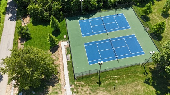
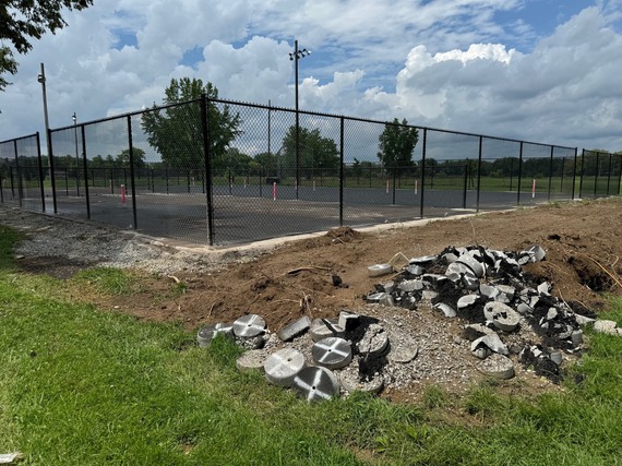
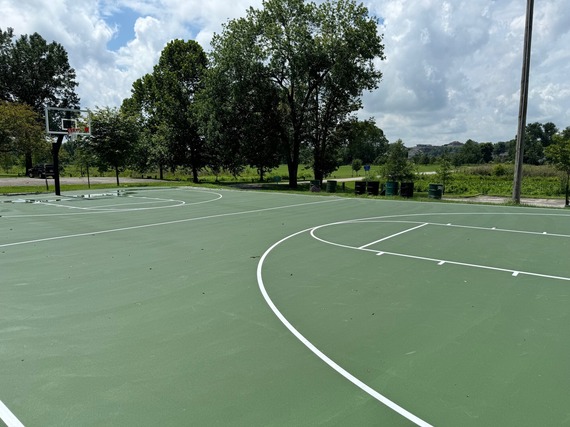
I am proud to report that Metro Parks is making great progress at Hays Kennedy Park. We are hopeful that we will be able to host a ribbon cutting ceremony in the near future.
Last year I secured $300,000 in the FY2024 Budget to improve Hays Kennedy Park’s tennis and basketball courts. In partnership with Metro Parks, we have provided a much-needed resurfacing to the tennis courts, basketball courts, while providing new pickleball courts.
In this year’s FY2025 budget, I secured an additional $70,000 with the goal of improving the parking lots. I look forward to securing more funds for needed improvements to the park in future budget cycles.
Improving your safety and fixing our infrastructure has been my primary focus. With more than 30 million allocated towards paving and fully funding our police and other emergency services, I worked to bring investments like this to our parks.
As a result, we will be seeing improvements not only at Hays Kennedy Park but also at Locust Grove, Thurman Hutchins Park and Cox Park. Most of these projects will address needs such as restroom rehabilitation or leaking roofs, but each will help to make our community a better place to live and play.
Sincerely,
Scott Reed

There are approximately 100 boards and commissions with many areas of interest, including business and economic development, land planning, parks and recreation, public health and public safety.
If you are interested in volunteering for one of Louisville Metro Government's Boards and Commissions, now is the time to start. By being a part of a board or commission, you will offer your time and your talents to improve the quality of life in our community.
To learn more please visit Boards and Commission.
|
 Waterfront Park Phase IV is the 22-acre westward expansion of the park between 10th and 14th streets along the river. Once completed, this $50 million project will transform a long-neglected area of our waterfront into a vibrant community amenity and bring Waterfront Park’s world class amenities within a 20-minute walk of more than 10,000 residents. Phase IV is a vital component of Waterfront Park’s mission to transform our waterfront into an accessible community asset that can be enjoyed by the community forever.
Construction is underway on PlayPort at Waterfront Park, a children’s area designed in partnership with Kentucky Science Center. PlayPort will feature large-scale authentic objects – including an excavator, dump truck, boats, river-themed elements, and more – as anchors for an inspired play and learning environment. Construction of PlayPort is expected to be completed by the end of 2024.
To learn more about Waterfront Park Phase IV and share your thoughts, visit https://ourwaterfrontparkexpansion.org.
LOUISVILLE, Ky. (Aug. 9, 2024) – The Kentucky Transportation Cabinet (KYTC) advises motorists of single lane closures on River Road Monday, Aug. 12, in downtown Louisville.
Consultant engineers will perform the routine hands-on inspection of the Interstate 64 bridge over River Road from mile point 4.6 to mile point 5.0 (near the North Preston Street and East Witherspoon Street intersection). The inspection will require single lane closures on River Road from 9 a.m. to 4 p.m.
Motorists should heed signage and use caution while traveling through the work zone.
LOUISVILLE, Ky. (Aug. 9, 2024) – The Kentucky Transportation Cabinet (KYTC) advises motorists of weekend lane closures on the I-64 East Kentucky River Bridge in Franklin County.
As part of the ongoing preventative maintenance project, the right lane of I-64 East near mile marker 55 will be closed from Friday, Aug. 9, at 6 p.m., until Saturday evening. Following the closure of the right lane, a traffic shift will occur and the left lane will be closed through Monday, Aug. 12, at 5 a.m.
During the lane closures, an 11-foot-wide lane will be maintained for traffic. Motorists should heed signage, use caution, and expect delays when traveling through the work zone.
| JEFFERSON COUNTY |
|
| I-64 / I-71 / I-265 (I-MoveKY) |
Find the latest project updates here: https://i-moveky.com/.
|
| Sherman Minton Bridge |
I-64 & U.S. 150 over the Ohio River between Louisville, KY, and New Albany, IN.
Find the latest project updates here: https://shermanmintonrenewal.com/.
|
| River Road |
Traffic Impacts: Single lane closures.
Date/Time: Monday, August 12, from 9 a.m. to 4 p.m.
Project Limits: River Road, under the I-64 bridge from mile point 4.6 to mile point 5.0 (near the North Preston Street and East Witherspoon Street intersection).
Type of Work: Routine hands-on inspection of the I-64 bridge.
Other Details: Motorists should heed signage and use caution while traveling through the work zone.
|
| KY 22 (Brownsboro Road)/Springcrest Drive Intersection |
Traffic Impacts: Lane closure.
Date/Time: Through project completion, expected for the fall of 2024.
Project Limits: KY 22 (Brownsboro Road) between Cliffwynde Trce and Pine Hurst Lane.
Type of Work: The reconstruction of two 11-foot travel lanes and a left turn lane at the Springcrest Drive intersection are included in this project. A 6-foot sidewalk will also be installed along the north side of KY 22 between the entrance just east of Cliffwynde Trce and Brownhurst Cove Road.
Other Details: Alternating one-way traffic will be maintained through project completion, and motorists will be directed through the work zone via temporary signals.
Project details: https://transportation.ky.gov/DistrictFive/Pages/KY-22-(Brownsboro-Road)-and-Springcrest-Drive-Intersection-Improvement-Project----Project-5-371.10---CID-231311.aspx
|
| U.S. 42 (Brownsboro Road/Mellwood Avenue) |
Traffic Impacts: Lane closures and traffic shifts.
Date/Time: Daily from 7:30 a.m. to 5 p.m.
Project Limits: U.S. 42 (Brownsboro Road/Mellwood Avenue) between Spring Street and Chenoweth Lane.
Type of Work: Asphalt resurfacing and rightsizing project.
Other Details: Public outreach for the rightsizing portion of the project was conducted by Louisville Metro Government's Office of Planning. More information regarding the rightsizing portion of the project can be found online, including striping plans.
*The project is expected to be completed by the end of August. Temporary message signs displaying "New Traffic Pattern Ahead" will be installed to alert motorists of the changes, along with new permanent regulatory signs.
|
| I-64 East & West |
Traffic Impacts: Lane closures, traffic shifts and rolling roadblocks possible.
Date/Time: Daily/Nighty.
Project Limits: Near mile marker 19, extending to the Shelby County line.
Type of Work: Roadway rehabilitation project in Jefferson and Shelby Counties.
Other Details: *Project press release.
|
| I-64 East & West *Various Exit Ramps |
Traffic Impacts: Intermittent lane and ramp closures and delays possible.
Date/Time: Weekdays – 9:00 a.m. to 3 p.m., and 8 p.m. to 6 a.m. | Weekends – Friday at 8:00 p.m. through Monday at 6:00 a.m.
Project Limits: Various interchange exit ramps on I-64.
Type of Work: Upgrade and install wrong way pavement markings and signs.
Other Details: The Highway Safety Improvement Project will install and enhance wrong way signs and pavement markings on all District 5 interstate exit ramps to discourage wrong way driving. Motorists should reduce speeds and obey traffic control while workers are present. This project is set to be completed by fall 2025.
|
| I-264 East and West (Watterson Expressway) |
Traffic Impacts: Intermittent lane closures.
Date/Time: Nightly – 8 p.m. to 5 a.m., including weekends.
Project Limits: I-264 from I-64 interchange at mile marker 0, extending to East I-65 at mile point 12.7.
Type of Work: Pavement striping and pavement marker installation.
|
I-264 (Watterson Expressway)
*Various Exit Ramps |
Traffic Impacts: Intermittent lane and ramp closures.
Date/Time: Nightly – 8 p.m. to 6 a.m. | Daily – 9 a.m. to 3 p.m.
Project Limits: Various interchange Exit ramps on I-264.
Type of Work: Upgrade and install wrong way pavement markings and signs.
Other Details: The Highway Safety Improvement Project will install and enhance wrong way signs and pavement markings on various interstate exit ramps to discourage wrong way driving. Motorists should reduce speeds and obey traffic control while workers are present. This project is set to be completed by the fall of 2024.
|
| I-265 (Gene Snyder Freeway) |
Traffic Impacts: Lane and shoulder closures possible.
Date/Time: Daily – 9 a.m. to 3 p.m.
Project Limits: The bridge over KY 61 (Preston Highway) at mile point 11.83.
Type of Work: Bridge cleaning/painting and joint repairs.
Other Details: Motorists should use caution when traveling through the work zone.
|
| KY 864 (Logan Street/Shelby Street) |
Traffic Impacts: Sidewalk and lane closures possible.
Date/Time: Daily.
Project Limits: Between Goss Avenue and East Gray Street.
Type of Work: One-way to two-way conversion.
Other Details: Work is underway ahead of asphalt resurfacing and the two-way conversion of the roadway.
*https://transportation.ky.gov/DistrictFive/Pages/Jefferson-County-KY-864-Shelby-Street-and-Logan-Street-One-way-to-Two-way-Conversion.aspx
|
| KY 1065 (Outer Loop) |
Traffic Impacts: Lane closures and traffic shifts possible.
Date/Time: Daily/nightly.
Project Limits: From mile point 5.470 (near Briarcliff Road) to mile point 7.717 (near Donegal Drive)
Type of Work: Concrete rehabilitation project including the milling and removal of sections of existing concrete pavement with the replacement of new concrete pavement.
Other Details: Motorists should obey restrictions and use caution when traveling through the work zone.
|
| KY 1819 (Billtown Road) |
Traffic Impacts: Lane closures and delays possible.
Date/Time: Daily – 9 a.m. to 4 p.m.
Project Limits: Three sections of KY 1819/Billtown Road (Easum Road through Mary Dell Lane, Michael Edward Drive through Fairground Road and Shady Acres Lane through Colonnades Place).
Type of Work: Reconstruction of KY 1819 (Billtown Road) from north of Colonnades Place to south of Easum Road with new traffic signals, signal optimization, turn lanes, storage lanes, etc. (varying by intersection based on existing conditions and future traffic projections for the location).
Other Details: The project is expected to be completed by the summer of 2025.
*https://transportation.ky.gov/DistrictFive/Pages/KY-1819-Billtown-Road-Reconstruction---Project-05-8203.aspx
|
| KY 3084 (Old Henry Road) |
Traffic Impacts: Lane closures and traffic shifts possible.
Date/Time: Daily/nightly.
Project Limits: From Twin Creek Road to Woodmont Branch.
Type of Work: Major roadway construction.
Other Details: This project is expected to be completed in the winter of 2024/2025.
*This work is part of the KY 3084/KY 362 construction project.
|
| Scenic Loop in Cherokee Park |
Traffic Impacts: Road/bridge closure.
Project Limits: Bridge over the Middle Fork of Beargrass Creek (mile point 1.796) in Cherokee Park.
Detour: Beals Branch Road, Lexington Road (U.S. 60A), and Cochran Hill Road.
Type of Work: Bridge replacement.
Other Details: Project completion is expected for the summer of 2024.
|
| Jefferson County (Various Locations) |
Traffic Impacts: Lane closures and delays possible as a part of a mobile operation.
Date/Time: Nightly – 7 p.m. to 6 a.m.
Type of Work: Pavement striping.
Other Details: Motorists should provide plenty of space to crews displaying "WET PAINT" signage and be observant of slowed vehicles while traveling through the work zone.
|
| |
|
| BULLITT COUNTY |
|
| KY 44 (Old Mill Road) |
Traffic Impacts: Lane closures, traffic shifts and delays possible.
Date/Time: Daily/nightly.
Project Limits: From the I-65 ramps at mile point 13.039 in Shepherdsville to just east of Snapp Street at mile point 22.991 in Mt. Washington.
Type of Work: Asphalt resurfacing.
Other Details: The expected completion date is the summer of 2024.
|
| I-65 North and South |
Traffic Impacts: Changing traffic patterns, lane shifts, and closures possible.
Date/Time: Daily/nightly.
Project Limits: From mile point 104.7 to mile point 110.7 (Bullitt and Hardin Counties).
Type of Work: Full concrete pavement removal and asphalt pavement replacement. Other improvements to the corridor include bridge repairs, subgrade repairs, and guardrail repairs/installation.
Other Details: The project is expected to be completed by the fall of 2024: https://transportation.ky.gov/DistrictFive/Pages/Bullitt-County-I65-Roadway-Rehabilitation.aspx
|
| KY 480 (Cedar Grove Road) |
Traffic Impacts: Changing traffic patterns, lane shifts, and closures possible as construction progresses.
Date/Time: Daily/nightly.
Project Limits: On KY 480 (between I-65) from mile point 0.6 to mile point 1.4.
Type of Work: Construction of a Double Crossover Diamond interchange.
Other Details: The project is expected to be completed by the fall of 2025.
https://transportation.ky.gov/DistrictFive/Pages/I-65-at-KY-480-interchange-improvements-in-Bullitt-County.aspx
|
| |
|
| FRANKLIN COUNTY |
|
| I-64 East & West |
Traffic Impacts: Closure of the right shoulder near both eastbound and westbound bridges.
Date/Time: Daily.
Project Limits: I-64 Bridges over the Kentucky River and KY 1659.
Type of Work: Preventative maintenance project for the I-64 Bridges over the Kentucky River in Franklin County.
Other Details: The project is expected to be completed by the fall of 2024.
*Project press release.
**The right lane of I-64 East near mile marker 55 will be closed from Friday, Aug. 9, at 6 p.m., until Saturday evening. Following the closure of the right lane, a traffic shift will occur and the left lane will be closed through Monday, Aug. 12, at 5 a.m.
|
| I-64/U.S. 127 Interchange |
Traffic Impacts: Lane closures on U.S. 127 near the I-64 interchange. Two 10-foot travel lanes will be maintained in each direction, with nightly lane reductions possible.
Date/Time: Nightly.
Project Limits: I-64/U.S. 127 interchange.
Type of Work: The realigning of the I-64 West off-ramp to U.S. 127 North, as well as the realigning of the I-64 West on-ramp from U.S. 127. Other improvements include the installation of a new signalized intersection on U.S. 127 to provide access to development entrances, which will be activated following project completion. Additionally, the intersection of Westridge Drive and Leonardwood Drive will be reconstructed to accommodate dual left turns onto Westridge Drive from U.S. 127.
Other Details: *Project press release.
The project is expected to be completed by the summer of 2025.
|
| U.S. 421 (Bald Knob Road) |
Traffic Impacts: Lane closures and delays possible.
Date/Time: Daily.
Project Limits: North of Clifty Drive at mile point 5.315 to Dry Ridge Road at mile point 11.132.
Type of Work: Improvements to the asphalt pavement, shoulder repairs, guardrail repairs/installations, and the construction of a retaining wall at mile point 9.46 (adjacent to Stoney Creek) for slope stabilization.
Other Details: Alternating one-way traffic will be maintained through project completion, and motorists will be directed through the work zone via temporary signals.
*A 9-foot-wide lane will be maintained for traffic through project completion, which is scheduled for the fall of 2024.*
|
| |
|
| HENRY COUNTY |
|
| I-71 North & South |
Traffic Impacts: Lane closures, traffic shifts and delays possible.
Date/Time: Nightly – 7 p.m. to 7 a.m.
Project Limits: I-71 North and South between mile point 28.17 (at the bridge over Little Kentucky River) and mile point 37.18 (near the bridge over KY 55).
Type of Work: Milling and removal of the existing asphalt surface followed by resurfacing with new asphalt pavement. Additional improvements include guardrail repairs and repairs to the roadbed under the highway at some locations.
Other Details: This project is expected to be completed by the fall of 2024. Project press release.
|
| KY 55 (Eminence Pike) |
Traffic Impacts: Lane closures, traffic shifts and delays possible.
Date/Time: Daily/nightly.
Project Limits: KY 55 (Eminence Pike) at mile point 0.0 (near the Henry/Shelby County line), extending north to KY 1899 at mile point 0.737.
KY 55 at mile point 12.4, extending North to the Shelby/Henry County line at mile point 20.251.
Type of Work: Rumble strip installation and striping following asphalt resurfacing.
Other Details: Motorists will be directed through the work zone via flagging operations. This project is expected to be completed by the fall of 2024.
|
| KY 146 (La Grange Road) |
Traffic Impacts: Lane closures. Motorists may be directed through the work zone via flagging operations as construction progresses.
Date/Time: Daily/nightly.
Project Limits: From mile point 2.82 to mile point 2.92 (at Little Kentucky River Bridge).
Type of Work: Major realigning and widening of the roadway.
Other Details: Motorists may be directed through the work zone via flagging operations as construction progresses. This project is expected to be completed in the fall of 2024.
https://transportation.ky.gov/DistrictFive/Pages/Henry-County-KY-146-Realignment-and-Widening-Project-05-80260.aspx
|
| KY 389 (River Road) |
Traffic Impacts: Lane closures, traffic shifts and delays possible.
Date/Time: Daily.
Project Limits: KY 389 (River Road) from KY 193 at mile point 19.764, extending north to the Henry/Carroll County line at mile point 21.791.
Type of Work: Final striping following asphalt resurfacing.
Other Details: Motorists will be directed through the work zone via flagging operations. The expected completion date is set for the fall of 2024.
|
| |
|
| OLDHAM COUNTY |
|
| I-71 North and South |
Traffic Impacts: Lane closures, traffic shifts, and delays possible.
Date/Time: Daily/nightly.
Project Limits: Between mile marker 18 (near KY 393) and mile marker 22 (near South First Avenue).
Type of Work: The I-71 rehabilitation project includes the milling and removal of the existing asphalt pavement with the replacement of new asphalt pavement. Other improvements to the corridor include bridge repairs, subgrade repairs, and guardrail repairs/installations.
Other Details: Motorists should heed restrictions, proceed cautiously through the work zone, or seek an alternate route. The project is expected to be completed by the fall of 2024. More details here.
|
| KY 329 |
Traffic Impacts: Lane closures, traffic shifts, and traffic stops possible as construction progresses.
Date/Time: Daily/nightly.
Project Limits: KY 329 and KY 329 bypass (Veterans Memorial Parkway) intersection, just south of Interstate 71.
Type of Work: Major realigning and widening of the roadway.
Other Details: The project is expected to be completed in the spring of 2025.
|
| KY 329B |
Traffic Impacts: Lane closures, traffic shifts and delays possible.
Date/Time: Daily/nightly.
Project Limits: KY 329B from mile point 0.150, extending east to KY 22 at mile point 2.062.
Type of Work: Asphalt resurfacing.
Other Details: Motorists will be directed through the work zone via flagging operations. The expected completion date for this project is set for the fall of 2024.
|
| KY 3084 (Old Henry Road) |
Traffic Impacts: Road closure.
Project Limits: From KY 3084 (mile point 0) to KY 362/Ash Avenue (mile point .32).
Type of Work: Construction of a 3-lane roadway.
Other Details: This project includes grading work, drainage, and asphalt surface with the bridge. The project is expected to be completed in the winter of 2024/2025.
*Continuation of KY 3084 project listed under Jefferson County.
|
| |
|
| SHELBY COUNTY |
|
| KY 44 (Mount Eden Road) |
Traffic Impacts: Lane closures, traffic shifts and delays possible.
Date/Time: Daily/nightly.
Project Limits: KY 44 (Mount Eden Road) at mile point 3.250 near KY 53/KY 714, extending east to the Beach Creek Bridge at mile point 4.131.
Type of Work: Asphalt resurfacing.
Other Details: Motorists will be directed through the work zone via flagging operations. The expected completion date for this project is set for the fall of 2024.
|
| KY 1399 (Veechdale Road) |
Traffic Impacts: Lane closures, traffic shifts and delays possible.
Date/Time: Daily/nightly.
Project Limits: KY 1399 (Veechdale Road) at mile point 0.000 at Taylor Wood Road, extending north to McDowell Court at mile point 2.046.
Type of Work: Asphalt resurfacing.
Other Details: Motorists will be directed through the work zone via flagging operations. The expected completion date for this project is set for the fall of 2024.
|
| I-64 East & West |
Traffic Impacts: Lane closures and traffic shifts possible.
Date/Time: Daily/nightly.
Project Limits: Between mile point 19.44 and mile point 27.88, extending to Jefferson County.
Type of Work: Roadway rehabilitation project.
Other Details: Motorists should use caution while traveling through the work zone.
|
| |
|
| SPENCER COUNTY |
|
| KY 55 (Taylorsville Road) |
Traffic Impacts: Lane closures, traffic shifts and delays possible.
Date/Time: Daily/nightly.
Project Limits: KY 55 (Taylorsville Road) from the Salt River Bridge at mile point 6.307 extending north to KY 155 at mile point 11.270.
Type of Work: Asphalt resurfacing.
Other Details: Motorists will be directed through the work zone via flagging operations. The expected completion date for this project is set for the fall of 2024.
|
| KY 248 (Briar Ridge Road) |
Traffic Impacts: Lane closures, traffic shifts and delays possible.
Date/Time: Daily/nightly.
Project Limits: Ky 1399 (Briar Ridge Road) at mile point 2.687 at the east end of Little Beech Creek Bridge, extending east to the Spencer/Anderson County line at mile point 7.778.
Type of Work: Asphalt resurfacing.
Other Details: Motorists will be directed through the work zone via flagging operations. The expected completion date for this project is set for the fall of 2024.
|
| KY 1060 (Plum Creek Road) |
Traffic Impacts: Road closure.
Date/Time: Beginning Monday, July 15, for 180 days.
Project Limits: At the bridge located at mile point 1.63 on KY 1060 (near the KY 1060 (Plum Creek Road) and KY 1169 (Plum Rdge Road) intersection).
Detour: The suggested detour is to follow KY 1060 to KY 44 then proceed to KY 1319 to reconnect with KY 1060 and vice versa.
Type of Work: Bridge replacement.
Other Details: The project includes the demolition of the existing bridge and the construction of the replacement bridge. Motorists should obey restrictions, follow the signed detour and plan ahead when traveling. The project is expected to be completed by January 2025.
|
| |
|
| TRIMBLE COUNTY |
|
| Milton-Madison Bridge (U.S. 421) |
Traffic Impacts: Lane closures and traffic shifts possible.
Date/Time: Daily.
Project Limits: U.S. 421 over the Ohio River between Milton, KY, and Madison, IN.
Type of Work: Joint sealing and final striping as part of the preventative maintenance project.
Other Details: The project is expected to be completed by the fall of 2024. *Project press release.
|
We now have a new way for you to map crime around you. Just click here and view our new interactive crime mapping tool for Division 5 & 8 or for each beat in Division 5 & 8. And save it in your favorites to view crime anytime it's updated daily. On the page is a Quickfind tool that allows you to put your address in and subscribe to crime trends, alerts and block watch reports for your police beat. Forward this email to your friends and family!
For further information on Councilman Scott Reed or District 16 please visit www.louisvilleky.gov/government/metro-council-district-16
You can also reach out directly by phone at 502.574.1116 or by email at scott.reed@louisvilleky.gov.
601 West Jefferson Street
Louisville, KY 40202
Having Trouble Viewing this eNewsletter? Click here to view it on the web.
|


