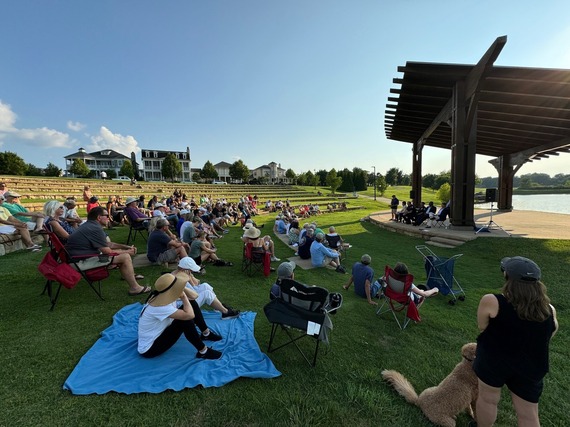
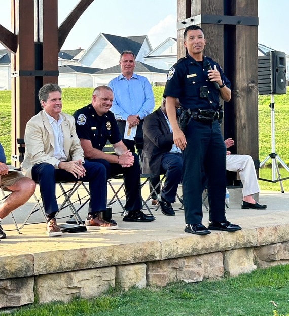
 Thank you to everyone who joined us last night!
We had an excellent turnout at the Norton Commons Amphitheater last evening, discussing public safety and crime prevention.
Thanks to LMPD, Kevin Harned, the Norton Commons HOA, State Representative Ken Fleming, and Deputy Mayor David James for taking the time to discuss city and state strategies to curtail crime in Norton Commons and the city. Very much appreciated!!
-Scott
In June, I requested a meeting with LMPD to discuss the increase of car thefts that impacted Northeastern Jefferson County. I wanted to learn more about the department’s efforts to combat this critical issue, as well as any obstacles that were preventing officers from being able to apprehend the people involved in these criminal acts.
During this meeting I was informed of several efforts already underway as well as ongoing plans to apprehend the groups of individuals who were organized in striking a variety of neighborhoods throughout the city. We also reviewed the needs of the department related to additional cameras as well as the need to review mask policies that have led many criminals to use COVID-era masking as a means for preventing our cameras and police from being able to identify those driving stolen vehicles and attempting to remove items from cars.
Since our meeting, we are happy to report that LMPD has had success arresting a number of people in connection with these crimes and continues to follow up on other leads. Unfortunately, their actions alone can’t solve this problem. We need to have judges who will hold those convicted of these crimes accountable and we need your help as well.
According to police nearly 90% of car robberies and thefts are due to vehicles being unlocked with valuables readily available and in sight. In addition – many of the vehicles stolen aren’t hot-wired like we see in the movies, but rather the result of an owner leaving their unlocked car with the keys or car fob, in the car. Please make sure you are locking your cars and removing valuables from sight whenever you leave your vehicle. Please remember, that we are working hard to get more officers on the streets, but we can all help create a safer neighborhood by taking these preventative steps.

 Register today for the 5, 15, 35, 65, or 100 mile ride to further the life-saving mission of the Norton Cancer Institute and Norton Children's Cancer Institute!
Click Here to Register!

Are you interested in volunteering? Louisville Metro Government has more than 70 boards and commissions - everything from the board of the Louisville Water Company to Metro Parks to the Louisville Planning Commission. We are always in search of citizens willing to serve on boards. Most boards are voluntary-based and are not paid but the reward of serving pays big dividends to our community.
To complete an application, please visit https://louisvilleky.gov/government/mayor-craig-greenberg/interested-serving-board-or-commission
|
 Those of you who have watched MetroTV over the years have probably done so on Spectrum Cable channel 184 for the purpose of catching a Metro Council meeting, budget hearing, or maybe a press conference on something in which you were interested. MetroTV has now broadened its availability to include the options shown above. Not only that, its programming has expanded, too. Current shows include:
- ‘Louisville This Week’ – a weekly news magazine
- ‘alDia en Louisville’ – a Spanish language talk show hosted by Jose Donis
- ‘Uniquely Louisville’ – spotlighting the people, places, and events that make our city special
- ‘Park it Here’ – stories about our great park system
- ‘Family Friendly Foods’ – for those who want ideas on feeding their family (who couldn't use more ideas for dinner!), and
‘Metro Council Chronicles’ – members of the Metro Council take you through special places and events in their districts

Visit the Metro Animal Services website to view some of what they offer. Below is a list of a few of specific sites:
Adopt a Pet Long-Stay Champions License a Pet Foster a Pet Find/Report a Lost Pet Volunteer Donate Animal Abuse Registry
Click the following link to view: https://louisvilleky.gov/government/animal-services
Louisville Metro Animal Services (MAS) is the only open intake shelter in Jefferson County. Serving as an authority for public safety and the humane treatment of animals, MAS provides a wide range of services including adoption, foster, and volunteer programs, animal care and control enforcement, and collaborative efforts with local partners around our city. MAS strives to create a safer and more compassionate environment for all residents, human and animal alike.
For more information about Louisville Metro Animal Services, please visit www.lousivilleky.gov/government/animal-services
|
| JEFFERSON COUNTY |
|
| I-64 / I-71 / I-265 (I-MoveKY) |
Find the latest project updates here: https://i-moveky.com/.
|
| Sherman Minton Bridge |
I-64 & U.S. 150 over the Ohio River between Louisville, KY, and New Albany, IN.
Find the latest project updates here: https://shermanmintonrenewal.com/.
|
| KY 22 (Brownsboro Road)/Springcrest Drive Intersection |
Traffic Impacts: Lane closure.
Date/Time: Through project completion, expected for the fall of 2024.
Project Limits: KY 22 (Brownsboro Road) between Cliffwynde Trce and Pine Hurst Lane.
Type of Work: The reconstruction of two 11-foot travel lanes and a left turn lane at the Springcrest Drive intersection are included in this project. A 6-foot sidewalk will also be installed along the north side of KY 22 between the entrance just east of Cliffwynde Trce and Brownhurst Cove Road.
Other Details: Alternating one-way traffic will be maintained through project completion, and motorists will be directed through the work zone via temporary signals.
Project details: https://transportation.ky.gov/DistrictFive/Pages/KY-22-(Brownsboro-Road)-and-Springcrest-Drive-Intersection-Improvement-Project----Project-5-371.10---CID-231311.aspx
|
| I-64 East & West |
Traffic Impacts: Lane closures, traffic shifts and rolling roadblocks possible.
Date/Time: Daily/Nighty.
Project Limits: Near mile marker 19, extending to the Shelby County line.
Type of Work: Roadway rehabilitation project in Jefferson and Shelby Counties.
Other Details: *Project press release
|
| I-64 East & West (Various Exit Ramps) |
Traffic Impacts: Intermittent lane and ramp closures and delays possible.
Date/Time: Weekdays – 9:00 a.m. to 3 p.m., and 8 p.m. to 6 a.m. | Weekends – Friday at 8:00 p.m. through Monday at 6:00 a.m.
Project Limits: Various interchange exit ramps on I-64.
Type of Work: Upgrade and install wrong way pavement markings and signs.
Other Details: The Highway Safety Improvement Project will install and enhance wrong way signs and pavement markings on all District 5 interstate exit ramps to discourage wrong way driving. Motorists should reduce speeds and obey traffic control while workers are present. This project is set to be completed by fall 2025.
|
| I-264 East and West (Watterson Expressway) |
Traffic Impacts: Closure.
Project Limits: I-264 East and West will be closed in both directions from the I-264/I-64 interchange (mile point 18.7) to the I-264/I-71 interchange (mile point 22.7) from 7 a.m. to 5 p.m.
Detours:
· Drivers heading from I-71 South to I-264 West should take I-265 South. Then, take I-64 West to reach I-264 West.
· Drivers heading from I-71 North to I-264 West should continue on I-71 North. Then, take I-265 South to I-64 West to reach I-264 West.
· Drivers traveling on I-264 East to I-71 North or I-71 South should take I-64 East. Then, take I-265 North to reconnect with I-71.
Type of Work: LG&E crews will work on overhead electric transmission and distribution lines near U.S. 42 (Brownsboro Road) in preparation for the upcoming road widening project.
Other Details: Signs notifying motorists of the closure have been placed in the area. Drivers should plan ahead, expect delays, and follow the posted detour.
|
| I-264 East and West (Watterson Expressway) |
Traffic Impacts: Intermittent lane closures.
Date/Time: Nightly – 8 p.m. to 5 a.m., including weekends.
Project Limits: I-264 from I-64 interchange at mile marker 0, extending to East I-65 at mile point 12.7.
Type of Work: Pavement striping and pavement marker installation.
|
| I-264 (Watterson Expressway) *Various Exit Ramps |
Traffic Impacts: Intermittent lane and ramp closures.
Date/Time: Nightly – 8 p.m. to 6 a.m. | Daily – 9 a.m. to 3 p.m.
Project Limits: Various interchange Exit ramps on I-264.
Type of Work: Upgrade and install wrong way pavement markings and signs.
Other Details: The Highway Safety Improvement Project will install and enhance wrong way signs and pavement markings on various interstate exit ramps to discourage wrong way driving. Motorists should reduce speeds and obey traffic control while workers are present. This project is set to be completed by the fall of 2024.
|
| I-265 (Gene Snyder Freeway) |
Traffic Impacts: Lane and shoulder closures possible.
Date/Time: Daily – 9 a.m. to 3 p.m.
Project Limits: The bridge over KY 61 (Preston Highway) at mile point 11.83.
Type of Work: Bridge cleaning/painting and joint repairs.
Other Details: Motorists should use caution when traveling through the work zone.
|
| KY 841 (Gene Snyder Freeway) |
Traffic Impacts: Lane closures possible.
Date/Time: Daily and nightly from 9 a.m. to 3 p.m., and 7 p.m. to 6 a.m., beginning Sunday, July 14, through Friday, July 19.
Project Limits: KY 841 North and South (Gene Snyder Freeway), between mile marker 35.0 and mile marker 37.7 (near and through the East End Tunnel).
Type of Work: Routine maintenance of the roadway and East End Tunnel.
Other Details: Motorists should heed signage, use caution, and adjust commutes to accommodate the lane closures.
|
| KY 864 (Logan Street/Shelby Street) |
Traffic Impacts: Sidewalk and lane closures possible.
Date/Time: Daily.
Project Limits: Between Goss Avenue and East Gray Street.
Type of Work: One-way to two-way conversion.
Other Details: Work is underway ahead of asphalt resurfacing and the two-way conversion of the roadway.
*https://transportation.ky.gov/DistrictFive/Pages/Jefferson-County-KY-864-Shelby-Street-and-Logan-Street-One-way-to-Two-way-Conversion.aspx
|
| KY 1065 (Outer Loop) |
Traffic Impacts: Lane closures and traffic shifts possible.
Date/Time: Daily/nightly.
Project Limits: From mile point 5.470 (near Briarcliff Road) to mile point 7.717 (near Donegal Drive)
Type of Work: Concrete rehabilitation project including the milling and removal of sections of existing concrete pavement with the replacement of new concrete pavement.
Other Details: Motorists should obey restrictions and use caution when traveling through the work zone.
|
| KY 1819 (Billtown Road) |
Traffic Impacts: Lane closures and delays possible.
Date/Time: Daily – 9 a.m. to 4 p.m.
Project Limits: Three sections of KY 1819/Billtown Road (Easum Road through Mary Dell Lane, Michael Edward Drive through Fairground Road and Shady Acres Lane through Colonnades Place).
Type of Work: Reconstruction of KY 1819 (Billtown Road) from north of Colonnades Place to south of Easum Road with new traffic signals, signal optimization, turn lanes, storage lanes, etc. (varying by intersection based on existing conditions and future traffic projections for the location).
Other Details: The project is expected to be completed by the summer of 2025.
*https://transportation.ky.gov/DistrictFive/Pages/KY-1819-Billtown-Road-Reconstruction---Project-05-8203.aspx
|
| KY 3084 (Old Henry Road) |
Traffic Impacts: Lane closures and traffic shifts possible.
Date/Time: Daily/nightly.
Project Limits: From Twin Creek Road to Woodmont Branch.
Type of Work: Major roadway construction.
Other Details:
- Phase 7:
The roadway is currently one lane in each direction between Bush Farm Road and Terrace Crossing.
*This work is part of the KY 3084/KY 362 construction project: https://transportation.ky.gov/DistrictFive/Pages/KY-3084-(Old-Henry-Road)-between-I-265-in-Jefferson-County-and-KY-362-(Ash-Avenue)-in-Oldham-County.aspx
|
| Scenic Loop in Cherokee Park |
Traffic Impacts: Road/bridge closure.
Project Limits: Bridge over the Middle Fork of Beargrass Creek (mile point 1.796) in Cherokee Park.
Detour: Beals Branch Road, Lexington Road (U.S. 60A), and Cochran Hill Road.
Type of Work: Bridge replacement.
Other Details: Project completion is expected for the summer of 2024.
|
| |
|
| BULLITT COUNTY |
|
| KY 44 (Old Mill Road) |
Traffic Impacts: Lane closures, traffic shifts and delays possible.
Date/Time: Daily/nightly.
Project Limits: From the I-65 ramps at mile point 13.039 in Shepherdsville to just east of Snapp Street at mile point 22.991 in Mt. Washington.
Type of Work: Asphalt resurfacing.
Other Details: The expected completion date is the summer of 2024.
|
| KY 61 North (North Preston Highway) |
Traffic Impacts: Lane closures, traffic shifts and delays possible.
Date/Time: Daily/nightly.
Project Limits: From mile point 19.351 (at KY 1526/John Harper Highway) extending North to mile point 20.053 (at KY 2553/Old Preston Highway).
Type of Work: Asphalt resurfacing.
Other Details: The expected completion date is the summer of 2024.
|
| I-65 North and South |
Traffic Impacts: Changing traffic patterns, lane shifts, and closures possible.
Date/Time: Daily/nightly.
Project Limits: From mile point 104.7 to mile point 110.7 (Bullitt and Hardin Counties).
Type of Work: Full concrete pavement removal and asphalt pavement replacement. Other improvements to the corridor include bridge repairs, subgrade repairs, and guardrail repairs/installation.
Other Details: The project is expected to be completed by the fall of 2024: https://transportation.ky.gov/DistrictFive/Pages/Bullitt-County-I65-Roadway-Rehabilitation.aspx
|
| KY 480 (Cedar Grove Road) |
Traffic Impacts: Changing traffic patterns, lane shifts, and closures possible as construction progresses.
Date/Time: Daily/nightly.
Project Limits: On KY 480 (between I-65) from mile point 0.6 to mile point 1.4.
Type of Work: Construction of a Double Crossover Diamond interchange.
Other Details: The project is expected to be completed by the fall of 2025.
https://transportation.ky.gov/DistrictFive/Pages/I-65-at-KY-480-interchange-improvements-in-Bullitt-County.aspx
|
| Bullitt County (Various locations) |
Traffic Impacts: Lane closures and delays possible as a part of a mobile operation.
Date/Time: Nightly – 8 p.m. to 5 a.m.
Type of Work: Pavement striping.
Other Details: Motorists should provide plenty of space to crews displaying "WET PAINT" signage and be observant of slowed vehicles while traveling through the work zone.
|
| |
|
| FRANKLIN COUNTY |
|
| I-64 East & West |
Traffic Impacts: Closure of the right shoulder near both eastbound and westbound bridges.
Date/Time: Daily.
Project Limits: I-64 Bridges over the Kentucky River and KY 1659.
Type of Work: Preventative maintenance project for the I-64 Bridges over the Kentucky River in Franklin County.
Other Details: The project is expected to be completed by the fall of 2024.
*Project press release.
|
| U.S. 421 (Bald Knob Road) |
Traffic Impacts: Lane closures and delays possible.
Date/Time: Daily.
Project Limits: North of Clifty Drive at mile point 5.315 to Dry Ridge Road at mile point 11.132.
Type of Work: Improvements to the asphalt pavement, shoulder repairs, guardrail repairs/installations, and the construction of a retaining wall at mile point 9.46 (adjacent to Stoney Creek) for slope stabilization.
Other Details: Alternating one-way traffic will be maintained through project completion, and motorists will be directed through the work zone via temporary signals. *A 9-foot-wide lane will be maintained for traffic through project completion, which is scheduled for the fall of 2024.*
|
| KY 2821 (Hanly Lane) |
Traffic Impacts: Road closure.
Date/Time: Nightly – 7 p.m. to midnight: Monday, July 15, through Thursday, July 18.
Project Limits: From mile marker 0 (near Deerwood Drive) to mile marker 2.4 (near Galbraith Road).
Type of Work: Cross drain replacement.
Other Details: Local traffic will be directed through the work zone via flagging measures. Following the replacement of the cross drain, crews will place a layer of dense-grade rock over the drain until asphalt can be laid. Drivers should exercise caution when driving over the newly replaced cross drain.
|
| |
|
| HENRY COUNTY |
|
| I-71 North & South |
Traffic Impacts: Lane closures, traffic shifts and delays possible.
Date/Time: Nightly – 7 p.m. to 7 a.m.
Project Limits: I-71 North and South between mile point 28.17 (at the bridge over Little Kentucky River) and mile point 37.18 (near the bridge over KY 55).
Type of Work: Milling and removal of the existing asphalt surface followed by resurfacing with new asphalt pavement. Additional improvements include guardrail repairs and repairs to the roadbed under the highway at some locations.
Other Details: This project is expected to be completed by the fall of 2024. Project press release.
|
| KY 55 (Eminence Pike) |
Traffic Impacts: Lane closures, traffic shifts and delays possible.
Date/Time: Daily/nightly.
Project Limits: KY 55 (Eminence Pike) at mile point 0.0 (near the Henry/Shelby County line), extending north to KY 1899 at mile point 0.737.
KY 55 at mile point 12.4, extending North to the Shelby/Henry County line at mile point 20.251.
Type of Work: Rumble strip installation and striping following asphalt resurfacing.
Other Details: Motorists will be directed through the work zone via flagging operations. This project is expected to be completed by the fall of 2024.
|
| KY 146 (La Grange Road) |
Traffic Impacts: Lane closures. Motorists may be directed through the work zone via flagging operations as construction progresses.
Date/Time: Daily/nightly.
Project Limits: From mile point 2.82 to mile point 2.92 (at Little Kentucky River Bridge).
Type of Work: Major realigning and widening of the roadway.
Other Details: Motorists may be directed through the work zone via flagging operations as construction progresses. This project is expected to be completed in the fall of 2024.
https://transportation.ky.gov/DistrictFive/Pages/Henry-County-KY-146-Realignment-and-Widening-Project-05-80260.aspx
|
| KY 389 (River Road) |
Traffic Impacts: Lane closures, traffic shifts and delays possible.
Date/Time: Daily.
Project Limits: KY 389 (River Road) from KY 193 at mile point 19.764, extending north to the Henry/Carroll County line at mile point 21.791.
Type of Work: Asphalt Resurfacing.
Other Details: Motorists will be directed through the work zone via flagging operations. The expected completion date is set for the fall of 2024.
|
| |
|
| OLDHAM COUNTY |
|
| I-71 North and South |
Traffic Impacts: Lane closures, traffic shifts, and delays possible.
Date/Time: Daily/nightly.
Project Limits: Between mile marker 18 (near KY 393) and mile marker 22 (near South First Avenue).
Type of Work: The I-71 rehabilitation project includes the milling and removal of the existing asphalt pavement with the replacement of new asphalt pavement. Other improvements to the corridor include bridge repairs, subgrade repairs, and guardrail repairs/installations.
Other Details: Motorists should heed restrictions, proceed cautiously through the work zone, or seek an alternate route. The project is expected to be completed by the fall of 2024. More details here.
|
| KY 329 |
Traffic Impacts: Lane closures, traffic shifts, and traffic stops possible as construction progresses.
Date/Time: Daily/nightly.
Project Limits: KY 329 and KY 329 bypass (Veterans Memorial Parkway) intersection, just south of Interstate 71.
Type of Work: Major realigning and widening of the roadway.
Other Details: The project is expected to be completed in the spring of 2025.
|
| KY 329B |
Traffic Impacts: Lane closures, traffic shifts and delays possible.
Date/Time: Daily/nightly.
Project Limits: KY 329B from mile point 0.150, extending east to KY 22 at mile point 2.062.
Type of Work: Asphalt resurfacing.
Other Details: Motorists will be directed through the work zone via flagging operations. The expected completion date for this project is set for the fall of 2024.
|
| KY 3084 (Old Henry Road) |
Traffic Impacts: Road closure.
Project Limits: From KY 3084 (mile point 0) to KY 362/Ash Avenue (mile point .32).
Type of Work: Construction of a 3-lane roadway.
Other Details: This project includes grading work, drainage, and asphalt surface with the bridge. The project is expected to be completed in the winter of 2024/2025.
*Continuation of KY 3084 project listed under Jefferson County.
|
| |
|
| SHELBY COUNTY |
|
| KY 55 (Eminence Pike) |
Traffic Impacts: Lane closures, traffic shifts and delays possible.
Date/Time: Daily/nightly.
Project Limits: KY 55 (Eminence Pike) at mile point 0.0 (near the Henry/Shelby County line), extending north to KY 1899 at mile point 0.737.
KY 55 at mile point 12.4, extending north to the Shelby/Henry County line at mile point 20.251.
Type of Work: Asphalt resurfacing.
Other Details: Motorists will be directed through the work zone via flagging operations. The expected completion date is the fall of 2024.
|
| I-64 East & West |
Traffic Impacts: Lane closures and traffic shifts possible.
Date/Time: Daily/nightly.
Project Limits: Between mile point 19.44 and mile point 27.88, extending to Jefferson County.
Type of Work: Roadway rehabilitation project.
Other Details: Motorists should use caution while traveling through the work zone.
|
| |
|
| SPENCER COUNTY |
|
| KY 1060 (Plum Creek Road) |
Traffic Impacts: Road closure.
Date/Time: Beginning Monday, July 15, for 180 days.
Project Limits: At the bridge located at mile point 1.63 on KY 1060 (near the KY 1060 (Plum Creek Road) and KY 1169 (Plum Ridge Road) intersection).
Detour: The suggested detour is to follow KY 1060 to KY 44 then proceed to KY 1319 to reconnect with KY 1060 and vice versa.
Type of Work: Bridge replacement.
Other Details: The project includes the demolition of the existing bridge and the construction of the replacement bridge. Motorists should obey restrictions, follow the signed detour and plan ahead when traveling. The project is expected to be completed by January 2025.
|
| |
|
| TRIMBLE COUNTY |
|
| U.S. 421 |
Traffic Impacts: Lane closures and traffic shifts possible.
Date/Time: Daily/nightly.
Project Limits: From mile point 7.6 to mile point 7.9.
Type of Work: Widening of the roadway and the construction of a left turn lane into Trimble County Jr. Sr. High School.
Other Details: Construction is set to be completed by the summer of 2024.
|
| Milton-Madison Bridge (U.S. 421) |
Traffic Impacts: Lane closures and traffic shifts possible.
Date/Time: Daily/nightly.
Project Limits: U.S. 421 over the Ohio River between Milton, KY, and Madison, IN.
Type of Work: Preventative maintenance project.
Other Details: *Project press release.
*The Milton-Madison Bridge will be reduced to one lane beginning Monday, July 8. Motorists will be directed through the work zone via a temporary signal. Drivers should heed the temporary signal, follow posted signs, and reduce speed when navigating through the work zone.
|
We now have a new way for you to map crime around you. Just click here and view our new interactive crime mapping tool for Division 5 & 8 or for each beat in Division 5 & 8. And save it in your favorites to view crime anytime it's updated daily. On the page is a Quickfind tool that allows you to put your address in and subscribe to crime trends, alerts and block watch reports for your police beat. Forward this email to your friends and family!
For further information on Councilman Scott Reed or District 16 please visit www.louisvilleky.gov/government/metro-council-district-16
You can also reach out directly by phone at 502.574.1116 or by email at scott.reed@louisvilleky.gov.
601 West Jefferson Street
Louisville, KY 40202
Having Trouble Viewing this eNewsletter? Click here to view it on the web.
|


