|
Preliminary Guidance for Tornado Debris Removal
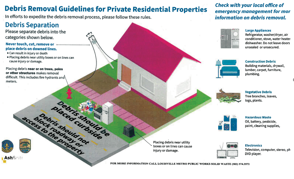
The City of Prospect and Louisville Metro have contracted with Ashbritt, a national disaster recovery and special environmental services contract, for free curbside tornado debris collection from residents in defined impacted areas.
Debris collection will begin on Monday, April 15th to give residents ample time to collect and transport the debris to the curb. All debris must be placed as close to the roadway as possible within the public right-of-way, in a grass area, not on pavement or in the public roadway, and not in or obstructing drainage ways, fire hydrant, or utility asset access. street curb.
Storm debris MUST be separated into the following categories:
- Vegetative debris
- Damaged home contents
- Construction & demolition debris.
For residents who need assistance with vegetative debris removal and chainsaw operations, Team Rubicon, a veteran-led humanitarian organization that serves global communities before, during, and after disasters and crises, will be available to assist.
Team Rubicon responded at the request of Kentucky Emergency Management with a Quick Reaction Force, performing chainsaw operations to clear trees, and fallen debris for the Prospect community – on the ground in less than 24 hours after the storm.
After coordinating with county emergency management in Henry, Oldham, and Jefferson Counties, Team Rubicon is planning a full operation with Greyshirt volunteers arriving today, April 5, and working through April 12.
This curbside pick-up is at no cost to the residents and is for tornado debris only, which includes construction and demolition items, household hazardous waste, electronics, brush, limbs that have fallen from trees or those that present a potential threat to safety.
These instructions are preliminary, however, we wanted to get residents the most up-to-date information before the weekend begins.
 ATTN PROSPECT RESIDENTS IMPACTED BY THE TORNADO: Curbside tornado debris collection starts Monday, April 15. We are still assessing who needs assistance getting debris to the curb. If you need assistance, take action NOW by calling Metro Solid Waste at 502-574-3572 to request assistance. Team Rubicon's deployment has concluded and we are actively looking for additional volunteer organizations to come in and assist. We thank Team Rubicon for all they have done for the 40059 community and nearby counties following the April 2 tornado.
LENSAlert & Smart91:
Opt-in for LENSAlert with your cell phone! Text "LENSAlert" to 67283 to start receiving emergency notifications. In 2016, Louisville Metro Emergency Services teamed up with Bullitt, Oldham, Nelson and Washington Counties to create a regional emergency notification system – Louisville Emergency Notification System (LENSAlert). Its enhanced capabilities include using all communications modes to send alerts – mobile phones, landlines, email, text, social media, and IPAWS-OPEN.
https://louisvilleky.gov/government/emergency-services/lensalert-smart911


 Attention Rental Property Owners,
The Department of Codes & Regulations has initiated their new Rental Registry program and your action is required. Property owners must register all their rental units with the city and pay a fee ranging from $25 to $250; failure to register is subject to a fine up to $100 per day per housing unit.
The registry will provide accurate and up-to-date contact information for property owners and management companies to help the city better identify and contact the responsible parties should Code Enforcement Officers find code violations at a rental property. Louisville Metro Government will randomly select properties from the list each year to undergo inspections to ensure the units meet the city code of ordinances.
Registration is available online at https://louisvilleky.gov/government/codes-regulations/. Property owners/managers may also apply in person with the Department of Codes & Regulations at 444 S. 5th St., Suite 200, Louisville, KY 40202.
 Louisville Metro Government has partnered with the Kentucky Solar Energy Society (KYSES) and the Louisville Sustainability Council (LSC) to launch the third annual solarize campaign, Solarize Louisville (formally known as Solar Over Louisville), to give residents and small businesses bulk-purchasing power to obtain discounted wholesale rates for solar installation through vetted installers. Going solar helps property owners save energy costs, support local clean energy jobs, and help Louisville meet its goal of 100% clean energy community-wide by 2040! In the past two years, 150+ residents went solar through Solarize Louisville. Our selected installers for 2024 are Icon Solar Power and Pure Power Solar. Both installers are reputable regional companies offering the same standard panel price with a 12-18% discount.
To sign up for solar or learn more, please visit: solarizelouisville.com. In addition, the Office of Sustainability will host two “Solar 101” workshops in April where community members can learn more about the program. Information and registration links can be found below.
- Solarize Louisville Workshop with Icon Solar Location: LFPL Main Library, 301 York St, Louisville, KY 40203 (in-person in the Board Room) Date: Saturday, April 6, 2024 Time: 11:00 - 12:00 p.m. Register for the workshop here.
Solarize Louisville Workshop with Pure Power Solar Location: Webex (virtual) Date: Thursday, April 18, 2024 Time: 7:00 PM - 8:00 PM Register for the workshop here.

 |
|
If you are interested in volunteering for one of Louisville Metro Government's Boards or Commissions, now is the time to start. By being a part of a board or commission, you will offer your time and your talents to improve the quality of life in our community.
There are approximately 100 boards and commissions with many areas of interest, including business and economic development, land planning, parks and recreation, public health and public safety.
Visit the website to learn more and apply!
|
| JEFFERSON COUNTY |
|
| I-64 / I-71 / I-265 (I-MoveKY) |
Find the latest project updates here: https://i-moveky.com/.
|
| Sherman Minton Bridge |
I-64 & U.S. 150 over the Ohio River between Louisville, KY, and New Albany, IN.
Find the latest project updates here: https://shermanmintonrenewal.com/.
|
| Clark Memorial Bridge/Second Street Bridge (U.S. 31) |
The Clark Memorial Bridge will close on Friday, April 12, at 2:30 p.m. (weather permitting) to remove the temporary traffic striping and clear construction equipment from the bridge, then re-stripe the roadway to restore the bridge to its normal traffic configuration – four lanes, with two lanes each direction.
*If there are no weather delays, northbound and southbound traffic is expected to resume by 5 p.m. Friday. In case of inclement weather, continued work, traffic closures, and the bridge’s reopening could occur on Saturday or Monday.
|
| KY 22 (Brownsboro Road)/Springcrest Drive Intersection |
Traffic Impacts: Lane closures, traffic shifts, and delays possible.
Date/Time: Daily/nightly.
Project Limits: KY 22 (Brownsboro Road)/Springcrest Drive intersection, near mile point 1.6.
Type of Work: The reconstruction of two 11-foot travel lanes and a left turn lane at the Springcrest Drive intersection are included in this project. A 6-foot sidewalk will also be installed along the north side of KY 22 between the entrance just east of Cliffwynde Trce and Brownhurst Cove Road.
Other Details: During phase 2 of the project, KY 22/Brownsboro Road will be reduced to one lane between Cliffwynde Trace and Pine Hurst Lane. Temporary signals will be placed to direct traffic through the work zone and will remain in place through the completion of the project.
* Springcrest Drive at KY 22/Brownsboro Road is closed as of Saturday, December 9. The existing lane closure on KY 22/Brownsboro Road, as well as the closure of Springcrest Drive at KY 22/Brownsboro Road, will continue through project completion, anticipated for the summer of 2024. *
https://transportation.ky.gov/DistrictFive/Pages/KY-22-(Brownsboro-Road)-and-Springcrest-Drive-Intersection-Improvement-Project----Project-5-371.10---CID-231311.aspx
|
| I-64 East & West |
Traffic Impacts: Lane closures.
Date/Time: Nightly from 6 p.m. to 6 a.m.
Project Limits: Near mile marker 19, extending to the Shelby County line.
Type of Work: Spot base repairs for the roadway rehabilitation project in Jefferson and Shelby Counties.
Other Details: *Project press release
|
| I-71 North |
Traffic Impacts: Lane closures possible.
Date/Time: Thursday, April 18, from 9 a.m. to 3 p.m.
Project Limits: I-71 North between Zorn Ave and I-264 (Watterson Expressway), near mile point 4.6.
Type of Work: Graffiti removal from overhead sign.
|
| I-71 South |
Traffic Impacts: Lane closures possible.
Date/Time: Friday, April 19, from 9 a.m. to 3 p.m.
Project Limits: I-71 South between Zorn Ave and I-64, near mile point 1.0.
Type of Work: Graffiti removal from overhead sign
|
| KY 155 (Taylorsville Road) |
Traffic Impacts: Lane closures possible.
Date/Time: Daily – 9 a.m. to 3 p.m.
Project Limits: South Pope Lick Road intersection, near mile point 4.9.
Type of Work: Reconstruction of the KY 155 (Taylorsville Road) and South Pope Lick Road intersection and bridge over Pope Lick Creek.
Other Details: This project is pending final resurfacing, which is set to occur in the spring of 2024.
|
| I-264 (Watterson Expressway) |
Traffic Impacts: Right lane closures possible.
Date/Time: Thursday, April 18, from 9 a.m. to 3 p.m.
Project Limits: I-264 East between U.S. 60 (Shelbyville Rd) and KY 1447 (Westport Rd), near mile point 20.3.
Type of Work: Graffiti removal from overhead sign.
|
| KY 864 (Logan Street/Shelby Street) |
Traffic Impacts: Sidewalk closures and lane closures possible.
Date/Time: Daily.
Project Limits: Between Goss Avenue and East Gray Street.
Type of Work: One-way to two-way conversion.
Other Details: Preliminary work is currently taking place ahead of asphalt resurfacing and the two-way conversion.
https://transportation.ky.gov/DistrictFive/Pages/Jefferson-County-KY-864-Shelby-Street-and-Logan-Street-One-way-to-Two-way-Conversion.aspx
|
| KY 3077 (River Road) |
Traffic Impacts: Left lane closures possible.
Date/Time: Friday, April 19, from 9 a.m. to 3 p.m.
Project Limits: KY 3077 (River Rd), just West of 2nd Street, near MP 0.4.
Type of Work: Graffiti removal from overhead sign.
|
| KY 3084 (Old Henry Road) |
Traffic Impacts: Lane closures.
Date/Time: Daily/nightly.
Project Limits: From Twin Creek Road to Woodmont Branch.
Type of Work: Major roadway construction.
Other Details:
· Phase 6 begins Monday, April 15:
The roadway will be one lane in each direction between Bush Farm Road and Terrace Crossing.
The intersection of Bush Farm Road and Old Henry Road will be back open to traffic*
*This work is part of the KY 3084/KY 362 construction project: https://transportation.ky.gov/DistrictFive/Pages/KY-3084-(Old-Henry-Road)-between-I-265-in-Jefferson-County-and-KY-362-(Ash-Avenue)-in-Oldham-County.aspx
|
| Scenic Loop in Cherokee Park |
Traffic Impacts: Road/bridge closure.
Project Limits: Bridge over the Middle Fork of Beargrass Creek (mile point 1.796) in Cherokee Park.
Detour: Beals Branch Road, Lexington Road (U.S. 60A), and Cochran Hill Road.
Type of Work: Bridge replacement.
Other Details: Work has resumed on the bridge replacement project and Bridge # 2 will remain closed through project completion, expected for the summer of 2024.
|
| Jefferson County (Various Locations) |
Traffic Impacts: Lane closures and delays are possible as a part of a mobile operation.
Date/Time: Nightly from 7 p.m. to 6 a.m.
Type of Work: Pavement marker (reflector) installations.
Other Details: Motorists should be observant of all road work signage and provide plenty of space for slowed vehicles while moving through the work zone.
|
| |
|
| BULLITT COUNTY |
|
| KY 61 (Preston Highway) |
Traffic Impacts: Lane closures, traffic shifts and delays possible.
Date/Time: Daily.
Project Limits: From mile point 0.016 (near the northern end of Wilson Creek Bridge) extending north to mile point 1.467 (near Maraman Road).
Type of Work: Asphalt resurfacing.
Other Details: Motorists will be directed through the work zone via flagging operations. The expected completion date is the fall of 2024.
|
| I-65 North and South |
Traffic Impacts: Changing traffic patterns, lane shifts, and closures possible.
Date/Time: Daily/Nightly.
Project Limits: From mile point 104.7 to mile point 110.7 (Bullitt and Hardin Counties).
Type of Work: Full concrete pavement removal and asphalt pavement replacement. Other improvements to the corridor include bridge repairs, subgrade repairs, and guardrail repairs/installation.
Other Details: https://transportation.ky.gov/DistrictFive/Pages/Bullitt-County-I65-Roadway-Rehabilitation.aspx
* Lane shifts will occur Monday, April 15, through Wednesday, April 17, for contract crews to extend the current two-lane traffic configuration to and through the bridges over Rolling Fork, at the Hardin County line.
|
| KY 480 (Cedar Grove Road) |
Traffic Impacts: Changing traffic patterns, lane shifts, and closures possible as construction progresses.
Date/Time: Daily/nightly
Project Limits: On KY 480 (between I-65) from mile point 0.6 to mile point 1.4.
Type of Work: Construction of a Double Crossover Diamond interchange.
Other Details: This project is expected to be completed by the fall of 2025.
https://transportation.ky.gov/DistrictFive/Pages/I-65-at-KY-480-interchange-improvements-in-Bullitt-County.aspx
|
| |
|
| FRANKLIN COUNTY |
|
|
I-64 East & West
|
Traffic Impacts: Lane shifts, rolling roadblocks, and traffic delays possible.
Date/Time: Daily.
Project Limits: Between mile markers 47 and 52.
Type of Work: Four sets of bridges being replaced are over KY 2817 (Cardwell Lane) at mile point 51.5; KY 151 (Graefenburg Road) at mile point 46.4, South Benson Creek at mile point 49.1 and KY 1665 (Evergreen Road) at mile point 49.8. Flagging operations may be required on KY 151, KY 1665, and KY 2817.
Detour: Oversized vehicles are alerted to an 11-foot width restriction for eastbound and westbound directions in the construction zone. These vehicles can utilize U.S. 60 and U.S. 127 as a detour.
Other Details: The project is expected to be completed in the spring of 2024.
*Crews will be removing barrier walls the week of Monday, April 8, requiring nightly lane closures.
|
| I-64 East & West |
Traffic Impacts: Closure of the right shoulder on the westbound bridge.
Date/Time: Daily.
Project Limits: I-64 Bridges over the Kentucky River and KY 1659.
Type of Work: Preventative maintenance project for the I-64 Bridges over the Kentucky River in Franklin County.
Other Details: The project is expected to be completed by the fall of 2024. *Project press release.
|
(Various Locations)
U.S. 127 (Lawrenceburg Road), U.S. 420 (West Main Street), U.S. 421 (Versailles Road), and U.S. 460 (East Main Street) |
Traffic Impacts: Lane closures possible.
Date/Time: Daily – 9 a.m. to 3 p.m.
Project Limits: Various routes on U.S. 127 (Lawrenceburg Road), U.S. 420 (West Main Street), U.S. 421 (Versailles Road), and U.S. 460.
Type of Work: Sidewalk reconstruction with ADA enhancements.
Other Details: This project is nearly complete, pending final striping which is set to occur in the spring of 2024.
|
| U.S. 421 (Bald Knob Road) |
Traffic Impacts: Lane closures and delays possible.
Date/Time: Daily.
Project Limits: North of Clifty Drive at mile point 5.315 to Dry Ridge Road at mile point 11.132.
Type of Work: Improvements to the asphalt pavement, shoulder repairs, guardrail repairs/installations, and the construction of a retaining wall at mile point 9.46 (adjacent to Stoney Creek) for slope stabilization.
Other Details: Alternating one-way traffic will be maintained through project completion, and motorists will be directed through the work zone via temporary signals. *A 9-foot-wide lane will be maintained for traffic through project completion, which is scheduled for the fall of 2024.*
|
| U.S. 421 (Thornhill Bypass) |
Traffic Impacts: Lane closures, traffic shifts and delays possible.
Date/Time: Daily.
Project Limits: U.S. 460/U.S. 60 interchange at mile point 3.072, extending to the KY 2261 overpass at mile point 4.503.
Type of Work: Asphalt resurfacing.
Other Details: The expected completion date is the spring of 2024.
|
| |
|
| HENRY COUNTY |
|
| I-71 North & South |
Traffic Impacts: Lane closures, traffic shifts and delays possible.
Date/Time: Daily.
Project Limits: I-71 North and South between mile point 28.17 (at the bridge over Little Kentucky River) and mile point 37.18 (near the bridge over KY 55).
Type of Work: Milling and removal of the existing asphalt surface followed by resurfacing with new asphalt pavement. Additional improvements include guardrail repairs and repairs to the road bed under the highway at some locations.
Other Details: This project is expected to be completed by the fall of 2024.
*Project press release.
|
| KY 146 (La Grange Road) |
Traffic Impacts: Lane closures. Motorists may be directed through the work zone via flagging operations as construction progresses.
Date/Time: Daily/nightly.
Project Limits: From mile point 2.82 to mile point 2.92 (at Little Kentucky River Bridge).
Type of Work: To allow the crew to begin work on structures on the other side of the bridge.
Other Details: Motorists may be directed through the work zone via flagging operations as construction progresses. This project is expected to be completed in the fall of 2024.
|
| |
|
| OLDHAM COUNTY |
|
| I-71 North and South |
Traffic Impacts: Lane closures and delays possible.
Date/Time: Daily/nightly.
Project limits: Between mile point 19.5 and mile point 21.5.
Type of Work: Construction of new interchange ramps at KY 2857 (La Grange Parkway) between KY 53 and KY 393.
Other Details: Motorists should heed any restrictions, cautiously proceed through the work zone, or seek an alternate route. The expected completion date for the interchange project is the fall of 2024.
Project details: https://transportation.ky.gov/DistrictFive/Pages/New-I-71-Interchange-in-Oldham-County.aspx
|
| I-71 North and South |
Traffic Impacts: Lane closures, traffic shifts, and delays possible.
Date/Time: Daily/nightly.
Project Limits: Between mile marker 18 (near KY 393) and mile marker 22 (near South First Avenue).
Type of Work: The I-71 rehabilitation project includes the milling and removal of the existing asphalt pavement with the replacement of new asphalt pavement. Other improvements to the corridor include bridge repairs, subgrade repairs, and guardrail repairs/installations.
Other Details: Motorists should heed restrictions, proceed cautiously through the work zone, or seek an alternate route. The project is expected to be completed by the fall of 2024. More details here.
|
| KY 329 |
Traffic Impacts: Lane closures, traffic shifts, and traffic stops possible as construction progresses.
Date/Time: Daily/nightly.
Project Limits: KY 329 and KY 329 bypass (Veterans Memorial Parkway) intersection, just south of Interstate 71.
Type of Work: Major realigning and widening of the roadway.
Other Details: The project is expected to be completed in the spring of 2025.
*Daily blasting operations will occur on weekdays around noon, as crews prepare the roadway for the widening and realignment project. Motorists should anticipate temporary traffic stops in both directions lasting up to 30 minutes during the blasting and should proceed with caution through the work zone or seek an alternate route.
|
| KY 3084 (Old Henry Road) |
Traffic Impacts: Roadway closure.
Project Limits: From KY 3084 (mile point 0) to KY 362/Ash Avenue (mile point .32).
Type of Work: Construction of a 3-lane roadway.
Other Details: This project includes grading work, drainage, and asphalt surface with the bridge. The project is expected to be completed in the winter of 2024/2025.
*Continuation of KY 3084 project listed under Jefferson County.
|
| |
|
| SHELBY COUNTY |
|
| I-64 East & West |
Traffic Impacts: Left lane closures on the eastbound side.
Date/Time: Daily/nightly.
Project Limits: Between mile point 19.44 and mile point 27.88, extending to Jefferson County.
Type of Work: Roadway rehabilitation project.
Other Details: *Project press release
|
| KY 1005 (Vigo Road) & KY 1871 (Rocket Lane/Cranbourne Lane) |
Traffic Impacts: Lane closures, traffic shifts and delays possible.
Date/Time: Daily/nightly.
Project Limits: KY 1005 (Vigo Road) from mile marker 0 (near KY 43) extending east to KY 1817 at mile point 0.165. KY 1871 (Rocket Lane/Cranbourne Lane) at mile marker 0 (at U.S. 60) extending north to KY 1005 at mile point 2.089.
Type of Work: Asphalt resurfacing.
Other Details: Motorists will be directed through the work zone via flagging operations. The expected completion date is the summer of 2024.
|
| |
|
| SPENCER COUNTY |
|
| KY 1795 (Mill Road) |
Traffic Impacts: Road closure.
Date/Time: Daily from 9 a.m. to 3 p.m. and nightly from 6 p.m. to midnight, beginning Monday, April 15, through Friday, April 19.
Project Limits: From mile marker 0 to mile marker 4.5.
Type of Work: Cross drain replacements.
|
| Spencer County (Various Locations) |
Traffic Impacts: Lane closures and delays are possible as a part of a mobile operation.
Date/Time: Daily from 7 a.m. to 9 p.m.
Type of Work: Pavement striping.
Other Details: Motorists should provide plenty of space to crews displaying "WET PAINT" signage and be observant of slowed vehicles while traveling through the work zone.
|
| |
|
| TRIMBLE COUNTY |
|
| U.S. 421 |
Traffic Impacts: Lane closures and traffic shifts possible.
Date/Time: Daily/Nightly.
Project Limits: From mile point 7.6 to mile point 7.9.
Type of Work: Widening of the roadway and the construction of a left turn lane into Trimble County Jr. Sr. High School.
Other Details: Construction is set to be completed by the summer of 2024.
|
| Milton-Madison Bridge (U.S. 421) |
Traffic Impacts: Lane closures and traffic shifts possible.
Date/Time: Daily/nightly.
Project Limits: U.S. 421 over the Ohio River between Milton, KY, and Madison, IN.
Type of Work: Preventative maintenance project.
Other Details: *Project press release.
|
| KY 1256 (Fisher Ridge Road) |
Traffic Impacts: Lane closures and traffic shifts possible.
Date/Time: Daily from 9 a.m. to 3 p.m.
Project Limits: From mile marker 0 (Burkhardt Road) to mile marker 4 (north of KY 2890).
Type of Work: Asphalt resurfacing.
Other Details: The project is expected to be completed in the summer of 2024.
|
We now have a new way for you to map crime around you. Just click here and view our new interactive crime mapping tool for Division 5 & 8 or for each beat in Division 5 & 8. And save it in your favorites to view crime anytime it's updated daily. On the page is a Quickfind tool that allows you to put your address in and subscribe to crime trends, alerts and block watch reports for your police beat. Forward this email to your friends and family!
For further information on Councilman Scott Reed or District 16 please visit www.louisvilleky.gov/government/metro-council-district-16
You can also reach out directly by phone at 502.574.1116 or by email at scott.reed@louisvilleky.gov.
601 West Jefferson Street
Louisville, KY 40202
Having Trouble Viewing this eNewsletter? Click here to view it on the web.
|


