|
Happy Earth Day and welcome to the April 2022 edition of FGS News and Research. Today, more than 1 billion people will celebrate Earth Day globally. This day was designated 52 years ago to mark the birth of the modern environmental movement. Floridians still face many environmental challenges, but we have accomplished much since Earth Day was established. Some of our environmental challenges in Florida are related to karst. I encourage you to learn more about karst landscapes as part of the International Union of Speleology's Internationa Year of Caves and Karst. The celebration was organized to “help raise the level of understanding and respect for caves and karst as globally important physical, ecological and cultural systems.”
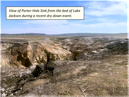
Florida is one of the world’s most recognized locations for karst topography. An example of one of the most common features found in karst regions is Porter Hole Sink, one of the largest active sinkholes in Lake Jackson, located in Leon County. In Florida, many lakes formed as the result of sinkhole activity. Over geologic time, sinkholes collapse and form depressions on the land surface. These depressions can coalesce and expand and deepen the lake basin. Porter Hole Sink is one of many sinks in Lake Jackson and, when conditions are favorable, water in the lake can drain through it, leaving behind a dry lakebed. Lake Jackson has experienced multiple dry down events since June 2021. This natural process provided an opportunity for scientific study over the past year.
The job of a geoscientist is dynamic and engaging. Florida’s geology is unique, fascinating, and more complicated than you might think! The following articles highlight some of the geologic wonders our state offers. Read about agatized corals and why they are important. Discover the complex mixture of limestone, fossil shell beds, quartz sand, and clay that makes up the Tamiami Formation. Learn about the geologic processes that create the breathtaking scenic views in Gold Head Branch and Ravine Gardens state parks.
When I became a professional geologist (P.G.) many years ago, I never imagined I would one day serve as State Geologist. Part of my role as State Geologist is to designate State Geologic Sites in Florida that contain unique and vital geologic features. I recently had the pleasure of designating Torreya State Park as Florida’s newest State Geologic Site. My career as a P.G. has been fulfilling. Could a fascinating career as a P.G. be in your future? Learn more about how to become a professional geologist.
Sincerely,

Guy H. Means, P.G. Administrator
Director and State Geologist
Florida Geological Survey
Florida Department of Environmental Protection


Florida’s abundance of marine life stretches from the Gulf of Mexico down to the warm waters of the Florida Keys and around to the Atlantic Coast. Vital to Florida’s marine ecosystem, corals are one of the state's many aquatic organisms.
What are corals and why are they important?
Corals are marine invertebrates of the phylum Cnidaria that typically form compact colonies of individual polyps attached to hard, underwater surfaces. When alive underwater, these polyps combine their own carbon dioxide with the lime in warm seawater to form a limestone-like hard surface, or coral. Corals first appeared in the geologic record in the late Cambrian Period but didn’t become widespread until the Ordovician Period 100 million years later. Corals can be found throughout the world's oceans in both shallow and deep water. However, the reef-building corals that rely on a symbiotic relationship with algae need shallow, clear water to allow for light penetration for photosynthesis.
According to the Florida Department of Environmental Protection’s Coral Reef Conservation Program, Florida’s coral reefs currently represent the third largest barrier reef ecosystem in the world. The reef tract in southern Florida extends 350 miles from the Dry Tortugas to the St. Lucie Inlet in Martin County. The only coral reef system in the continental United States, Florida's coral reef is home to over 40 species of reef-building corals that provide shelter, food and breeding sites for millions of plants and animals.
What are agatized corals?
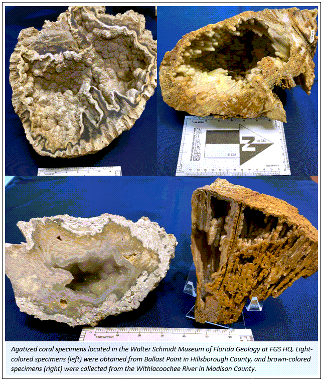
Agatized corals form when the fossil voids of ancient, buried corals are filled with groundwater containing various forms of the mineral silica. These fossil voids are filled with forms of quartz, the primary one being chalcedony, whose translucent varieties are referred to as “agatized,” or “agate.” The agatized corals in Florida are roughly 20 to 30 million years old, demonstrating how much time the geologic transformation from coral to agatized coral can require.
Agates are characterized by microcrystalline crystal sizes, banding, and rich coloration. Chalcedony is the most common variety of agate, but agatized corals may often exhibit rock crystal quartz, which occurs as delicate, white- to clear-colored, quartz crystal faces in void spaces in the coral.
Where can you find agatized corals?
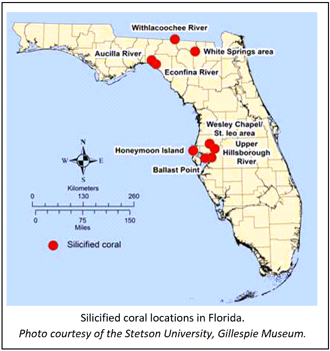
Agatized corals can be found in numerous locations throughout Florida, but the best-preserved examples are found in Tampa Bay (Ballast Point) and along the Withlacoochee, Suwannee and Econfina rivers.
Although Tampa Bay’s Ballast Point area has been a popular spot since the 1840s for finding specimens of agatized corals and various other silicified fossils, such as mollusks, mangrove roots, and crustaceans, many of these outcrops along the coast are no longer accessible due to growing population and infrastructure. Fortunately, other locations closer to the Georgia-Florida border are excellent and still preserved, and the majority of the agatized corals are found in the riverbeds and tributaries to the Withlacoochee, Suwannee, and Econfina rivers.
Contact: Benjamin L. Davis, Ph.D., GIT
References:
Florida’s Coral Reef
Coral Reef Conservation Program
Agatized (Fossil) Coralhttps://www.floridamuseum.ufl.edu/100years/agatized-fossil-coral/
|
Back to top
Geologic formations are the basic rock units used in stratigraphy, the branch of geology that deals with the layers of sedimentary rock (called strata) that have accumulated over geologic time.
The “Tamiami limestone” was named by Mansfield (1939) for a series of sandy limestone outcrops that were exposed during the digging of shallow ditches to form the roadbed of the Tamiami Trail in Collier and Monroe counties. The unit was formally renamed, revised, redescribed, and redefined as the Tamiami Formation by Parker and Cooke (1944). Since then, additional work on the Tamiami Formation has been done (see selected references below).
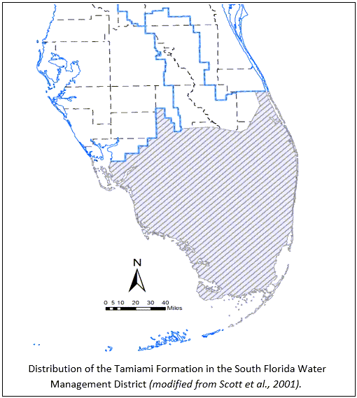
The Tamiami Formation was deposited in a warm, shallow sea in what is now Southwest Florida during the early Pliocene Epoch (5.3 to 3.6 million years ago). The Tamiami Formation consists of a complex mixture of limestone, fossil shell beds, quartz sand and clay. It occurs near the surface in Charlotte, Collier, Hendry, Lee, and Monroe counties in South Florida.
|
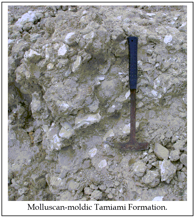
There are several recognized informal stratigraphic units within the Tamiami Formation. They include an oyster bed (Hyotissa), a quartz sand bed, the Ochopee Limestone, the Bonita Springs Marl, the Golden Gate Reef, the Pinecrest Sand, and the Buckingham Limestone. Each of these units represent different environments that existed during the deposition of the Tamiami Formation.
The lithology of the top of the Tamiami Formation, which can be highly variable over short distances, may include limestone, sandstone, quartz sand, marl, clay, or fossil shell beds. Geologists call these differences in lithology “facies”. Within the Tamiami Formation, facies are highly variable in thickness and change rapidly over short distances, making them difficult to delineate on geological maps.
The Tamiami Formation overlies formations within the Hawthorn Group. The base of the Tamiami Formation in Sarasota, Charlotte, and Lee counties occurs at the top of the first major green dolosilt/sand unit. In southern Lee County, there is a green dolosilt unit within the Tamiami Formation, and in this area the top of the Hawthorn Group occurs in a gray quartz sand unit. The Tamiami Formation occurs at land surface in parts of Southwest Florida. In places where it isn’t exposed, it is overlain by the undifferentiated Tertiary/Quaternary shell-bearing units (TQsu).
|
The Tamiami Formation is an important source of limestone, quartz sand, and fossil shell used for construction and road base in Southwest Florida. There are numerous pits and quarries where it is mined. The fossil shell beds in the Pincrest Sand are paleontologically significant and are known to contain one of the most diverse molluscan faunas in the world. It is estimated that between 800 and 1,200 different species of mollusks can be found in the Pincrest Sand. The chances are good that if you have decorative rocks in your yard that came from Southwest Florida, they are from the Tamiami Formation. See the following suggested references for more detailed information about the Tamiami Formation.
Contact: Rick Green, P.G. III
Selected References:
Hunter, M.E., and Wise, S.W., Jr., 1980, Possible restriction and redefinition of the Tamiami Formation in South Florida: Points for further discussion in P.J. Gleason, ed./, Water, Oil, and the Geology of Collier, Lee, and Hendry counties: Miami Geological Society Field Trip Guidebook, 1980, p. 41-44.
Mansfield, W.C., 1939, Notes on the Upper tertiary and Pleistocene Mollusks of Peninsular Florida: Florida Geological Survey Bulletin 18, 76p.
Meeder, J.F., 1987, The paleoecology, petrology, and depositional model of the Pliocene Tamiami Formation, southwest Florida (with special reference to corals and reef development): Ph.D. Dissertation, University of Miami, Coral Gables, Florida, 748 p.
Missimer, T.M., 1984, The geology of South Florida: A summary in P.J. Gleason, ed. Environments of South Florida, Present and Past II: Miami Geological Society Memoir 2, Coral Gables, Florida, p. 385-404.
Missimer, T.M., 1992, Stratigraphic relationships of sediment facies within the Tamiami Formation of Southwest Florida: Proposed intraformational correlations in T.M. Scott and W.D. Allman, editors, The Plio-Pleistocene Stratigraphy and Paleontology of South Florida: Florida Geological Survey Special Publication No. 36, p. 63-92.
Parker, G.G., and Cooke, C.W., 1944, Late Cenozoic Geology of Southern Florida, with a Discussion of the Ground Water: Florida Geological Survey Bulletin 27, 119p.
Scott, T.M., Campbell, K.M., Rupert, F.R., Arthur, J.D., Green, R.C., Means, G.H., Missimer, T.M., Lloyd, J.M., Yon, J.W., and Duncan, J.D., 2001, Geologic Map of the State of Florida: Florida Geological Survey Map Series 146, Scale 1:750,000.
Back to top
Mike Roess Gold Head Branch State Park and Ravine Gardens State Park contain intriguing examples of how geologic processes create captivating landscapes. Both parks have steephead ravines with ecosystems that are different from the surrounding uplands. Gold Head Branch State Park has sinkholes that resulted from dissolution of limestone in the subsurface.
Steepheads are interesting geologic features found in locations scattered across northern Florida. Rainwater falls on the land surface and slowly infiltrates the sand to create the surficial aquifer system. Steephead ravines develop where surficial aquifer system groundwater seeps out of the ground along a contact between underlying low permeability sediment and overlying unconsolidated sand. As water flows from the seeps, sand is eroded and a steephead ravine begins to develop. Over time, erosion causes the head of the ravine to migrate headward into the higher hills and a larger steephead ravine is formed.
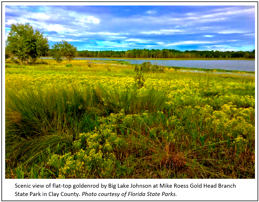
Mike Roess Gold Head Branch State Park
Mike Roess Gold Head Branch State Park is located in the rolling hills of northern Florida in Clay County. The northern part of the park is part of the landscape feature known as the Trail Ridge Province, where greater elevations are observed. In contrast, the southern area of the park is part of the Hawthorne Lakes Province, where sinkholes are more common.
The geologic story of the park begins with limestone found more than 200 feet below the land surface. The geologic formation known as the Ocala Limestone was deposited in a warm, shallow sea in the late Eocene Epoch nearly 34 million years ago. It is overlain by the Hawthorn Group, a lithostratigraphic unit. In northern Florida, the Hawthorn Group contains a mix of sand, clay, and carbonates (limestone and dolostone) that was deposited between 23 to 12 million years ago during the Miocene Epoch. Younger quartz sand deposits overlie the Hawthorn Group and form the land surface in Gold Head Branch State Park.
Limestone dissolves in fresh, slightly acidic groundwater, forming cavities. When the cavities collapse, overlying sediments move downward to fill the void, allowing a sinkhole to develop at the land surface. Sinkhole lakes, like Sheeler Lake in the northern part of the park, may form. In the southern part of Gold Head Branch State Park, a large area of coalesced sinkholes (including Little Lake Johnson and Big Lake Johnson) forms a basin. The sinkhole basin is important in the development of the park’s signature landforms, the steephead ravines.
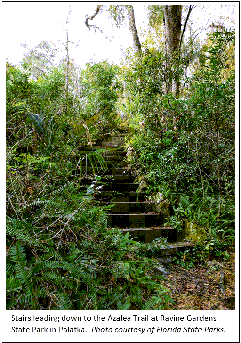
Ravine Gardens State Park
Located in Putnam County, Ravine Gardens State Park is on a landscape feature named Palatka Hill. Palatka Hill is a remnant of a broader, upland feature that was eroded, leaving an isolated hill that has higher elevation than the surrounding St. Johns River Offset Province.
The geologic story of the park begins with the Hawthorn Group, a mix of sand, clay and carbonates (limestone and dolostone) that was deposited between 23 to 12 million years ago during the Miocene Epoch. The Hawthorn Group is overlain by Pliocene and Pleistocene Epoch (5.3 million to 11,700 years ago) sediments. These sediments include the Cypresshead Formation and unnamed shell-bearing units, which contain variable amounts of clay that slows the downward flow of groundwater.
Groundwater flows through the permeable Cypresshead Formation sand until it encounters the lower permeability sediments, where the groundwater flows laterally toward the flanks of the Palatka Hill. Seepage springs form and slowly erode the sands, creating the steephead ravines. Over time, erosion has caused the head of the ravine to migrate into the Palatka Hill, creating the steephead ravines in the park.
Contact: Tom Scott, Ph.D, P.G.
|
Back to top
The Florida Geological Survey (FGS) recently named Torreya State Park the sixth State Geological Site in Florida, recognizing the park’s unique geological features, educational value, connection to the local ecosystem, and cultural significance. Legislation authorizes Florida’s State Geologist to designate State Geologic Sites at “locations of great and continuing significance to the scientific study and public understanding of the geological history of the state” (377.075(4)(e), Florida Statutes).
The Torreya State Park geologic site designation ceremony took place at the park, near Bristol, with a crowd of approximately 45 people. After the ceremony, FGS Director and State Geologist Guy “Harley” Means led a guided hike to explore geological features in the park.
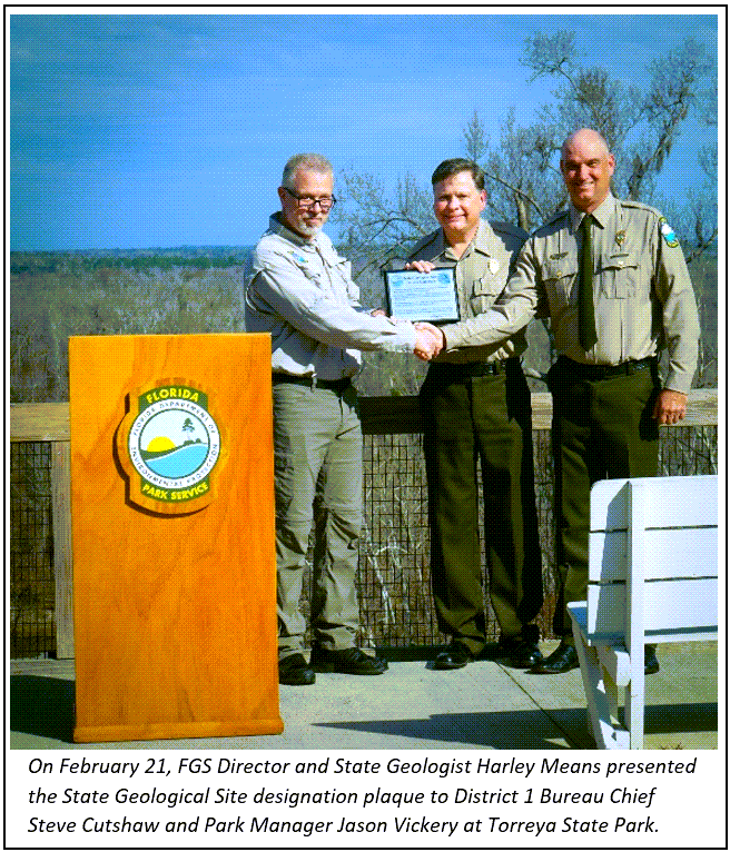
Torreya State Park was chosen for this designation, in part, because Rock Bluff, a steep, tall, limestone bluff is within the park. Rock Bluff is the “type section” of the nearly 19-million-year-old Torreya Formation. In addition to containing the Torreya Formation type section, the park also has marine fossils, including those of the dugong, a large marine mammal related to the manatee, that are found in the limestone formations exposed along the Apalachicola River and in streambeds within the park. Unique geological features can be observed along the park’s 16 miles of hiking trails.
The event was featured in the Jackson County Floridan. In a “Message from the Secretary” to Department employees dated Feb. 25, DEP Secretary Shawn Hamilton stated, “Please join me in thanking our FGS and Florida State Parks staff for their diligence in studying, protecting, and increasing awareness of this incredible geological site. I invite all of you to visit Torreya and our other award-winning state parks, trails, and historic sites throughout Florida.”
With the designation of Torreya State Park, there are now six state geological sites. Falling Waters State Park was designated in 2019. It joined Wakulla Springs and Florida Caverns state parks, along with Devil’s Millhopper and Windley Key Fossil Reef geological state parks. The state geologist will identify and designate more State Geological Sites in the coming years.
Please visit the December 2020 issue of FGS News and Research or Torreya State Park’s website for more information.
Contact: Sarah Erb
|
Back to top
 |
|
Located just north of Tallahassee, Lake Jackson has experienced a series of dry down events where part of the lake naturally drains into a sinkhole. The lake has drained five times over the past 10 months through Porter Hole Sink (since June 2021). These events provide a unique opportunity for scientists to study the geology, hydrology and biology of the lake.
Many may wonder where the water goes. Water draining through sinkholes and the lake bottom sediment percolates down into the underlying upper Floridan aquifer system, one of the most productive aquifers in the world. Once the water enters the aquifer, it can travel rapidly through caves and conduits.
|
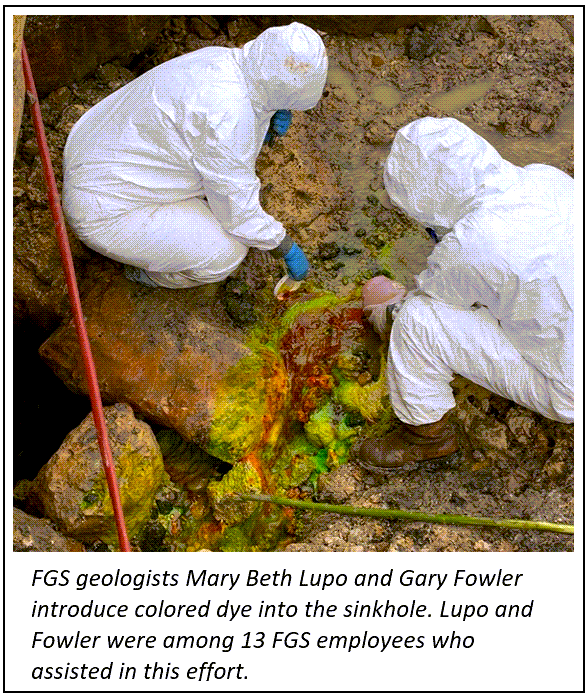
To discover where the lake water goes once it drains into the upper Floridan aquifer, FGS geoscientists released dye into Porter Sink on Aug. 14, 2021. The dye release - conducted in partnership with the Northwest Florida Water Management District - will allow scientists to learn more about groundwater flow in the underlying upper Floridan aquifer. This study involved introducing 52.5 pounds of non-toxic fluorescein dye directly into the sinkhole. This is an ongoing study and sites are being monitored down gradient from Porter Hole Sink to detect any passing dye.
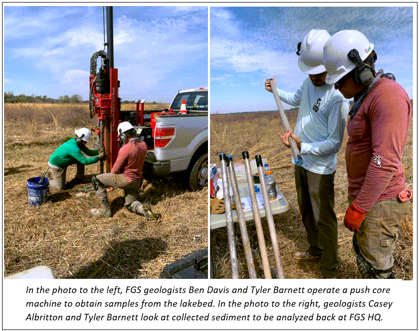
Last month, the FGS collected core samples for analysis from targeted areas of the Lake Jackson lakebed.
Historically, the FGS has used these natural draining events as research opportunities. During previous dry downs of Lake Jackson, the FGS has sampled lake sediment, explored the Porter Hole Sink cave system and conducted bathymetric surveys. The British Broadcasting Corporation aired an episode filmed at Lake Jackson and Lake Miccosukee sinkholes in Aug. 2011 that touched on the dry down event at Lake Jackson in 1999 for the series “Nature’s Weirdest Events.”
|
 |
For more information about research and local activities related to Lake Jackson, see the Friends of Lake Jackson’s latest newsletter, the Lake Jackson Voice.
Contact: Sarah Erb
Back to top
|