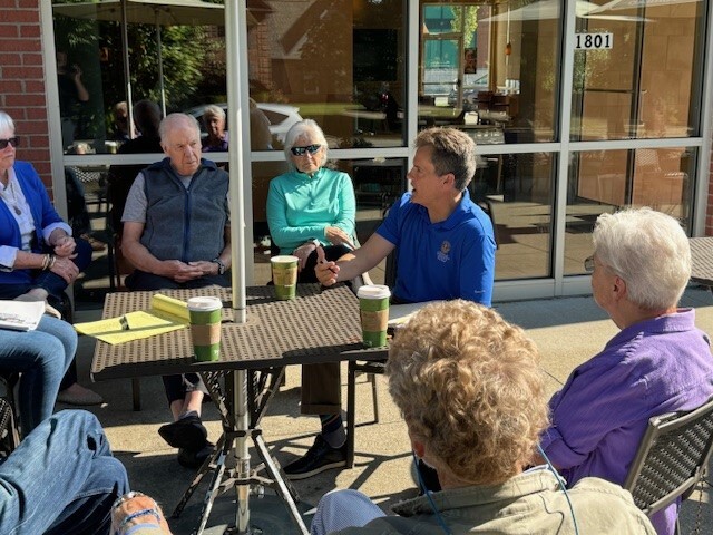
 Please be advised of a Coffee With Your Councilman event that is scheduled for next Saturday, August 3rd from 10:00 am to 11:00 am at Panera Bread at the corner of Rudy Lane and US 42.
This is an informal setting to meet Councilman Reed ask questions or provide suggestions you may have regarding District 16 or the larger Louisville community. You are welcome to stop by anytime between 10:00 and 11:00 am.
WHEN: Saturday, August 3rd, 2024 from 10:00 am to 11:00 am
WHERE: Panera Bread, 1801 Rudy Lane, Louisville, 40207
If you have questions about this event, please contact the District 16 office at 574-1116 or email Legislative Assistant Jared Townes at Jared.Townes@Louisvilleky.gov .

I am happy to report over the previous four reporting periods there have not been any reported thefts from vehicles in residential neighborhoods. As you may remember, there was a spike in this activity the beginning of June. The 8th Division, in collaboration with various units across the Louisville Metro Police Department, worked quickly to respond to the activity conducting several coordinated operations. These efforts resulted in several arrests and a relief from this type of criminal activity in our neighborhoods.
I am urging everyone to remain vigilant and proactive to help safeguard our community. A majority of car break-ins routinely involve unlocked vehicles and most stolen vehicles usually have the keys left inside them. Additionally, open garages are often targeted by criminals resulting in thefts from vehicles and auto thefts. By taking simple preventative measures, we can significantly reduce the attractiveness of our neighborhoods to criminals.
Please utilize the following prevention tips to reduce your chances of being victimized:
· REMOVE KEYS FROM INSIDE VEHICLES
· LOCK VEHICLE DOORS
· CLOSE GARAGES
· REMOVE GARAGE DOOR OPENERS FROM VEHICLES
· REMOVE ANY VALUABLES FROM INSIDE VEHICLES
Your cooperation is essential in making our neighborhoods safer and less appealing to potential thieves. By locking your vehicles and ensuring keys and garage door openers are not left inside vehicles, we can collectively deter criminal activity.
|
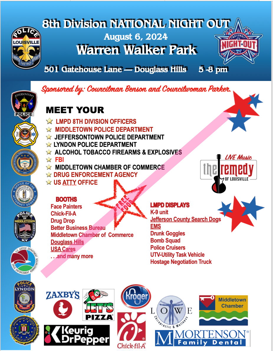
The Louisville Metro Police Foundation is partnering with the Victim Services Unit and 911 Cell Phone Bank (911cellphonebank.org) to conduct a cell phone drive. 911 Cell Phone Bank collects used working and non-working/broken cell phones, resets the devices to factory settings, guarantees complete data erasure and if they cannot erase the data, the device gets recycled through a licensed R2 recycler to keep the e-waste out of landfills, and provides the phones to law enforcement and victim services agencies for distribution to vulnerable residents in communities nationwide. Donating your old cell phone is a way to support the work of 911 Cell Phone Bank and give back to our community by ensuring victims of crime have meaningful access to emergency services. Cell phone drop boxes will be located at all National Night Out (8/6/2024 from 5:00 p.m. to 8:00 p.m.) locations to include the following:
1st and 2nd Divisions – Kroger (2710 W. Broadway, Louisville, KY 40211)
3rd and 4th Divisions – Iroquois Park (5216 New Cut Road, Louisville, KY 40214)
5th Division – Peterson-Dumesnil House (301 S. Peterson Avenue, Louisville, KY 40206)
6th and 7th Divisions – Highview Park (7201 Outer Loop, Louisville, KY 40228)
8th Division – Warren Walker Park (501 Gatehouse Lane, Louisville, KY 40243)


In addition to providing shade and beautifying neighborhoods, trees are powerful tools to slow down and soak up stormwater. This helps reduce erosion and improve water quality in Louisville’s waterways. These are just some of the reasons why MSD works with local organizations, neighborhood associations, and residents to plant 1000 trees each year. They hope you will consider being one of their tree planting partners this upcoming planting season!
MSD’s Urban Reforestation Grant Program is open to residents, organizations, companies, and agencies to support tree planting projects in MSD’s Jefferson County Drainage Service area. This includes all of Jefferson County except for the cities of Shively, Jeffersontown, St. Matthews and Anchorage. Please see the program guidelines and application in the attachment. The deadline to apply is Thursday August 1st at 5pm ET.
Please contact trees@louisvillemsd.org or call (502)540-6022 with any questions.
Application and Guidelines
https://louisvillemsd.org/trees
|
 |
Louisville Metro Animal Services and Kentucky Humane Society have joined BISSELL Pet Foundation to bring shelter wide FREE ADOPTIONS through July 31.
The adoption process hasn’t changed - fees are being covered by Bissell!
Anything that makes sounds, lights up, or turns on without being plugged in contains a battery. Batteries contain toxic metals, such as lead, cadmium and lithium that can be released into the environment when disposed of the wrong way.
All types of batteries, especially lithium, or Li-ion, also hold a small amount of charge, called a “residual” charge, after they are no longer strong enough to run a camera, toy, or other product. The residual charge or energy may be released as heat or fire if batteries are damaged or punctured. Batteries should always be stored so that the terminals (or + and – ends) are not touching each other or any type of metal. Store them in their original packaging which is designed to keep terminals separated.
Batteries should never be placed in a household recycling container! They won't be recycled and, depending on the battery type, they could cause a devastating fire!
If you are ready to recycle or dispose of batteries, follow these steps:
Step 1. Collect and sort your batteries by type. Use gloves. The batteries labeled "Alkaline", "General Use", or "Carbon Zinc" can be placed in the garbage since the recyclable content is low and they are not a fire or environmental hazard.
Step 2: Tape all battery terminals. ALL battery types (except alkaline) need to have the ends or terminals taped with clear tape. These are usually labeled with a + or -. This prevents them from linking together to generate hear or fire! Store them in a container (not airtight) until you are ready to take them to a retail store that accepts them or the HazBin.
Step 3: Find a battery recycler. Jefferson County residents can recycle household, rechargeable, and automotive batteries at the HazBin for free. Hardware stores, such as Lowe's and Home Depot, offer rechargeable battery recycling. Batteries Plus Bulbs stores also accept rechargeable batteries. Other types, like alkaline, may be accepted for a fee.
Download a printable flyer about battery disposal!
LOUISVILLE, Ky. (July 25, 2024) – The Kentucky Transportation Cabinet (KYTC) advises motorists of weekend lane closures on the I-64 West Kentucky River Bridge in Franklin County.
As part of the ongoing preventative maintenance project, the left lane of I-64 West near mile marker 55 will be closed from Friday, July 26, at 6 p.m., until Saturday evening. Following the closure of the left lane, the right lane will be closed from Saturday evening through Monday, July 29, at 5 a.m.
During the lane closures, an 11-foot-wide lane will be maintained for traffic. Motorists should heed signage, use caution, and expect delays when traveling through the work zone.
| JEFFERSON COUNTY |
|
| I-64 / I-71 / I-265 (I-MoveKY) |
Find the latest project updates here: https://i-moveky.com/.
|
| Sherman Minton Bridge |
I-64 & U.S. 150 over the Ohio River between Louisville, KY, and New Albany, IN.
Find the latest project updates here: https://shermanmintonrenewal.com/.
|
| KY 22 (Brownsboro Road)/Springcrest Drive Intersection |
Traffic Impacts: Lane closure.
Date/Time: Through project completion, expected for the fall of 2024.
Project Limits: KY 22 (Brownsboro Road) between Cliffwynde Trce and Pine Hurst Lane.
Type of Work: The reconstruction of two 11-foot travel lanes and a left turn lane at the Springcrest Drive intersection are included in this project. A 6-foot sidewalk will also be installed along the north side of KY 22 between the entrance just east of Cliffwynde Trce and Brownhurst Cove Road.
Other Details: Alternating one-way traffic will be maintained through project completion, and motorists will be directed through the work zone via temporary signals.
Project details: https://transportation.ky.gov/DistrictFive/Pages/KY-22-(Brownsboro-Road)-and-Springcrest-Drive-Intersection-Improvement-Project----Project-5-371.10---CID-231311.aspx
|
| U.S. 42 (Brownsboro Road/Mellwood Avenue) |
Traffic Impacts: Lane closures and traffic shifts.
Date/Time: Daily from 7:30 a.m. to 5 p.m.
Project Limits: U.S. 42 (Brownsboro Road/Mellwood Avenue) between Spring Street and Chenoweth Lane.
Type of Work: Asphalt resurfacing and rightsizing project.
Other Details: Public outreach for the rightsizing portion of the project was conducted by Louisville Metro Government's Office of Planning. More information regarding the rightsizing portion of the project can be found online, including striping plans.
*The project is expected to be completed by the end of August. Temporary message signs displaying "New Traffic Pattern Ahead" will be installed to alert motorists of the changes, along with new permanent regulatory signs.
|
| I-64 East & West |
Traffic Impacts: Lane closures, traffic shifts and rolling roadblocks possible.
Date/Time: Daily/Nighty.
Project Limits: Near mile marker 19, extending to the Shelby County line.
Type of Work: Roadway rehabilitation project in Jefferson and Shelby Counties.
Other Details: *Project press release
*Contract crews will implement rolling roadblocks and intermittent lane closures on Friday, July 26, from 7 p.m. to midnight. These measures are necessary to facilitate a traffic switch on the eastbound side, redirecting traffic from the inside lane and shoulder to the two outside lanes.
|
| I-64 East & West (Various Exit Ramps) |
Traffic Impacts: Intermittent lane and ramp closures and delays possible.
Date/Time: Weekdays – 9:00 a.m. to 3 p.m., and 8 p.m. to 6 a.m. | Weekends – Friday at 8:00 p.m. through Monday at 6:00 a.m.
Project Limits: Various interchange exit ramps on I-64.
Type of Work: Upgrade and install wrong way pavement markings and signs.
Other Details: The Highway Safety Improvement Project will install and enhance wrong way signs and pavement markings on all District 5 interstate exit ramps to discourage wrong way driving. Motorists should reduce speeds and obey traffic control while workers are present. This project is set to be completed by fall 2025.
|
| I-264 East and West (Watterson Expressway) |
Traffic Impacts: Intermittent lane closures.
Date/Time: Nightly – 8 p.m. to 5 a.m., including weekends.
Project Limits: I-264 from I-64 interchange at mile marker 0, extending to East I-65 at mile point 12.7.
Type of Work: Pavement striping and pavement marker installation.
|
| I-264 (Watterson Expressway) *Various Exit Ramps |
Traffic Impacts: Intermittent lane and ramp closures.
Date/Time: Nightly – 8 p.m. to 6 a.m. | Daily – 9 a.m. to 3 p.m.
Project Limits: Various interchange Exit ramps on I-264.
Type of Work: Upgrade and install wrong way pavement markings and signs.
Other Details: The Highway Safety Improvement Project will install and enhance wrong way signs and pavement markings on various interstate exit ramps to discourage wrong way driving. Motorists should reduce speeds and obey traffic control while workers are present. This project is set to be completed by the fall of 2024.
|
| I-265 (Gene Snyder Freeway) |
Traffic Impacts: Lane and shoulder closures possible.
Date/Time: Daily – 9 a.m. to 3 p.m.
Project Limits: The bridge over KY 61 (Preston Highway) at mile point 11.83.
Type of Work: Bridge cleaning/painting and joint repairs.
Other Details: Motorists should use caution when traveling through the work zone.
|
| KY 864 (Logan Street/Shelby Street) |
Traffic Impacts: Sidewalk and lane closures possible.
Date/Time: Daily.
Project Limits: Between Goss Avenue and East Gray Street.
Type of Work: One-way to two-way conversion.
Other Details: Work is underway ahead of asphalt resurfacing and the two-way conversion of the roadway.
*https://transportation.ky.gov/DistrictFive/Pages/Jefferson-County-KY-864-Shelby-Street-and-Logan-Street-One-way-to-Two-way-Conversion.aspx
|
| KY 1065 (Outer Loop) |
Traffic Impacts: Lane closures and traffic shifts possible.
Date/Time: Daily/nightly.
Project Limits: From mile point 5.470 (near Briarcliff Road) to mile point 7.717 (near Donegal Drive)
Type of Work: Concrete rehabilitation project including the milling and removal of sections of existing concrete pavement with the replacement of new concrete pavement.
Other Details: Motorists should obey restrictions and use caution when traveling through the work zone.
|
| KY 1819 (Billtown Road) |
Traffic Impacts: Lane closures and delays possible.
Date/Time: Daily – 9 a.m. to 4 p.m.
Project Limits: Three sections of KY 1819/Billtown Road (Easum Road through Mary Dell Lane, Michael Edward Drive through Fairground Road and Shady Acres Lane through Colonnades Place).
Type of Work: Reconstruction of KY 1819 (Billtown Road) from north of Colonnades Place to south of Easum Road with new traffic signals, signal optimization, turn lanes, storage lanes, etc. (varying by intersection based on existing conditions and future traffic projections for the location).
Other Details: The project is expected to be completed by the summer of 2025.
*https://transportation.ky.gov/DistrictFive/Pages/KY-1819-Billtown-Road-Reconstruction---Project-05-8203.aspx
|
| KY 3084 (Old Henry Road) |
Traffic Impacts: Lane closures and traffic shifts possible.
Date/Time: Daily/nightly.
Project Limits: From Twin Creek Road to Woodmont Branch.
Type of Work: Major roadway construction.
Other Details: This project is expected to be completed in the winter of 2024/2025.
*This work is part of the KY 3084/KY 362 construction project.
|
| Scenic Loop in Cherokee Park |
Traffic Impacts: Road/bridge closure.
Project Limits: Bridge over the Middle Fork of Beargrass Creek (mile point 1.796) in Cherokee Park.
Detour: Beals Branch Road, Lexington Road (U.S. 60A), and Cochran Hill Road.
Type of Work: Bridge replacement.
Other Details: Project completion is expected for the summer of 2024.
|
| Jefferson County (Various Locations) |
Traffic Impacts: Lane closures and delays possible as a part of a mobile operation.
Date/Time: Nightly – 7 p.m. to 6 a.m.
Type of Work: Pavement striping.
Other Details: Motorists should provide plenty of space to crews displaying "WET PAINT" signage and be observant of slowed vehicles while traveling through the work zone.
|
| |
|
| BULLITT COUNTY |
|
| KY 44 (Old Mill Road) |
Traffic Impacts: Lane closures, traffic shifts and delays possible.
Date/Time: Daily/nightly.
Project Limits: From the I-65 ramps at mile point 13.039 in Shepherdsville to just east of Snapp Street at mile point 22.991 in Mt. Washington.
Type of Work: Asphalt resurfacing.
Other Details: The expected completion date is the summer of 2024.
|
| KY 61 North (North Preston Highway) |
Traffic Impacts: Lane closures, traffic shifts and delays possible.
Date/Time: Daily/nightly.
Project Limits: From mile point 19.351 (at KY 1526/John Harper Highway) extending North to mile point 20.053 (at KY 2553/Old Preston Highway).
Type of Work: Asphalt resurfacing.
Other Details: The expected completion date is the summer of 2024.
|
| I-65 North and South |
Traffic Impacts: Changing traffic patterns, lane shifts, and closures possible.
Date/Time: Daily/nightly.
Project Limits: From mile point 104.7 to mile point 110.7 (Bullitt and Hardin Counties).
Type of Work: Full concrete pavement removal and asphalt pavement replacement. Other improvements to the corridor include bridge repairs, subgrade repairs, and guardrail repairs/installation.
Other Details: The project is expected to be completed by the fall of 2024: https://transportation.ky.gov/DistrictFive/Pages/Bullitt-County-I65-Roadway-Rehabilitation.aspx
|
| KY 480 (Cedar Grove Road) |
Traffic Impacts: Changing traffic patterns, lane shifts, and closures possible as construction progresses.
Date/Time: Daily/nightly.
Project Limits: On KY 480 (between I-65) from mile point 0.6 to mile point 1.4.
Type of Work: Construction of a Double Crossover Diamond interchange.
Other Details: The project is expected to be completed by the fall of 2025.
https://transportation.ky.gov/DistrictFive/Pages/I-65-at-KY-480-interchange-improvements-in-Bullitt-County.aspx
|
| |
|
| FRANKLIN COUNTY |
|
| I-64 East & West |
Traffic Impacts: Closure of the right shoulder near both eastbound and westbound bridges.
Date/Time: Daily.
Project Limits: I-64 Bridges over the Kentucky River and KY 1659.
Type of Work: Preventative maintenance project for the I-64 Bridges over the Kentucky River in Franklin County.
Other Details: The project is expected to be completed by the fall of 2024.
*Project press release.
**The right lane of I-64 West near mile marker 55 will be closed from Friday, July 26, at 6 p.m., until Saturday evening. Following the closure of the right lane, the left lane will be closed from Saturday evening through Monday, July 29, at 5 a.m.
|
| U.S. 421 (Bald Knob Road) |
Traffic Impacts: Lane closures and delays possible.
Date/Time: Daily.
Project Limits: North of Clifty Drive at mile point 5.315 to Dry Ridge Road at mile point 11.132.
Type of Work: Improvements to the asphalt pavement, shoulder repairs, guardrail repairs/installations, and the construction of a retaining wall at mile point 9.46 (adjacent to Stoney Creek) for slope stabilization.
Other Details: Alternating one-way traffic will be maintained through project completion, and motorists will be directed through the work zone via temporary signals. *A 9-foot-wide lane will be maintained for traffic through project completion, which is scheduled for the fall of 2024.*
|
| KY 1263 (Big Eddy Road) |
Traffic Impacts: Lane closures possible.
Date/Time: Daily.
Project Limits: From mile point 1.724, just South of Travis Circle, extending north to KY 420 at mile point 3.567.
Type of Work: Asphalt Resurfacing
Other Details: The expected completion date is the summer of 2024.
|
| |
|
| HENRY COUNTY |
|
| I-71 North & South |
Traffic Impacts: Lane closures, traffic shifts and delays possible.
Date/Time: Nightly – 7 p.m. to 7 a.m.
Project Limits: I-71 North and South between mile point 28.17 (at the bridge over Little Kentucky River) and mile point 37.18 (near the bridge over KY 55).
Type of Work: Milling and removal of the existing asphalt surface followed by resurfacing with new asphalt pavement. Additional improvements include guardrail repairs and repairs to the roadbed under the highway at some locations.
Other Details: This project is expected to be completed by the fall of 2024. Project press release.
|
| KY 55 (Eminence Pike) |
Traffic Impacts: Lane closures, traffic shifts and delays possible.
Date/Time: Daily/nightly.
Project Limits: KY 55 (Eminence Pike) at mile point 0.0 (near the Henry/Shelby County line), extending north to KY 1899 at mile point 0.737.
KY 55 at mile point 12.4, extending North to the Shelby/Henry County line at mile point 20.251.
Type of Work: Rumble strip installation and striping following asphalt resurfacing.
Other Details: Motorists will be directed through the work zone via flagging operations. This project is expected to be completed by the fall of 2024.
|
| KY 146 (La Grange Road) |
Traffic Impacts: Lane closures. Motorists may be directed through the work zone via flagging operations as construction progresses.
Date/Time: Daily/nightly.
Project Limits: From mile point 2.82 to mile point 2.92 (at Little Kentucky River Bridge).
Type of Work: Major realigning and widening of the roadway.
Other Details: Motorists may be directed through the work zone via flagging operations as construction progresses. This project is expected to be completed in the fall of 2024.
https://transportation.ky.gov/DistrictFive/Pages/Henry-County-KY-146-Realignment-and-Widening-Project-05-80260.aspx
|
| KY 389 (River Road) |
Traffic Impacts: Lane closures, traffic shifts and delays possible.
Date/Time: Daily.
Project Limits: KY 389 (River Road) from KY 193 at mile point 19.764, extending north to the Henry/Carroll County line at mile point 21.791.
Type of Work: Asphalt Resurfacing.
Other Details: Motorists will be directed through the work zone via flagging operations. The expected completion date is set for the fall of 2024.
|
| |
|
| OLDHAM COUNTY |
|
| I-71 North and South |
Traffic Impacts: Lane closures, traffic shifts, and delays possible.
Date/Time: Daily/nightly.
Project Limits: Between mile marker 18 (near KY 393) and mile marker 22 (near South First Avenue).
Type of Work: The I-71 rehabilitation project includes the milling and removal of the existing asphalt pavement with the replacement of new asphalt pavement. Other improvements to the corridor include bridge repairs, subgrade repairs, and guardrail repairs/installations.
Other Details: Motorists should heed restrictions, proceed cautiously through the work zone, or seek an alternate route. The project is expected to be completed by the fall of 2024. More details here.
|
| KY 329 |
Traffic Impacts: Lane closures, traffic shifts, and traffic stops possible as construction progresses.
Date/Time: Daily/nightly.
Project Limits: KY 329 and KY 329 bypass (Veterans Memorial Parkway) intersection, just south of Interstate 71.
Type of Work: Major realigning and widening of the roadway.
Other Details: The project is expected to be completed in the spring of 2025.
|
| KY 329B |
Traffic Impacts: Lane closures, traffic shifts and delays possible.
Date/Time: Daily/nightly.
Project Limits: KY 329B from mile point 0.150, extending east to KY 22 at mile point 2.062.
Type of Work: Asphalt resurfacing.
Other Details: Motorists will be directed through the work zone via flagging operations. The expected completion date for this project is set for the fall of 2024.
|
| KY 3084 (Old Henry Road) |
Traffic Impacts: Road closure.
Project Limits: From KY 3084 (mile point 0) to KY 362/Ash Avenue (mile point .32).
Type of Work: Construction of a 3-lane roadway.
Other Details: This project includes grading work, drainage, and asphalt surface with the bridge. The project is expected to be completed in the winter of 2024/2025.
*Continuation of KY 3084 project listed under Jefferson County.
|
| |
|
| SHELBY COUNTY |
|
| KY 55 (Eminence Pike) |
Traffic Impacts: Lane closures, traffic shifts and delays possible.
Date/Time: Daily/nightly.
Project Limits: KY 55 (Eminence Pike) at mile point 0.0 (near the Henry/Shelby County line), extending north to KY 1899 at mile point 0.737.
KY 55 at mile point 12.4, extending north to the Shelby/Henry County line at mile point 20.251.
Type of Work: Pavement markings following asphalt resurfacing.
Other Details: Motorists will be directed through the work zone via flagging operations. The expected completion date is the fall of 2024.
|
| I-64 East & West |
Traffic Impacts: Lane closures and traffic shifts possible.
Date/Time: Daily/nightly.
Project Limits: Between mile point 19.44 and mile point 27.88, extending to Jefferson County.
Type of Work: Roadway rehabilitation project.
Other Details: Motorists should use caution while traveling through the work zone.
|
| I-64 East |
Traffic Impacts: Closure of the right lane.
Date/Time: Monday, July 29, from 7 p.m. to 11:30 p.m.
Project Limits: From mile point 35.5 to mile point 36.2.
Type of Work: Base failure repairs.
Other Details: Motorists should use caution while traveling through the work zone.
|
| |
|
| SPENCER COUNTY |
|
| KY 1060 (Plum Creek Road) |
Traffic Impacts: Road closure.
Date/Time: Beginning Monday, July 15, for 180 days.
Project Limits: At the bridge located at mile point 1.63 on KY 1060 (near the KY 1060 (Plum Creek Road) and KY 1169 (Plum Ridge Road) intersection).
Detour: The suggested detour is to follow KY 1060 to KY 44 then proceed to KY 1319 to reconnect with KY 1060 and vice versa.
Type of Work: Bridge replacement.
Other Details: The project includes the demolition of the existing bridge and the construction of the replacement bridge. Motorists should obey restrictions, follow the signed detour and plan ahead when traveling. The project is expected to be completed by January 2025.
|
| |
|
| TRIMBLE COUNTY |
|
| U.S. 421 |
Traffic Impacts: Lane closures and traffic shifts possible.
Date/Time: Daily/nightly.
Project Limits: From mile point 7.6 to mile point 7.9.
Type of Work: Widening of the roadway and the construction of a left turn lane into Trimble County Jr. Sr. High School.
Other Details: Construction is set to be completed by the summer of 2024.
|
| Milton-Madison Bridge (U.S. 421) |
Traffic Impacts: Lane closures and traffic shifts possible.
Date/Time: Daily.
Project Limits: U.S. 421 over the Ohio River between Milton, KY, and Madison, IN.
Type of Work: Joint sealing and final striping as part of the preventative maintenance project.
Other Details: The project is expected to be completed by the fall of 2024. *Project press release.
|
We now have a new way for you to map crime around you. Just click here and view our new interactive crime mapping tool for Division 5 & 8 or for each beat in Division 5 & 8. And save it in your favorites to view crime anytime it's updated daily. On the page is a Quickfind tool that allows you to put your address in and subscribe to crime trends, alerts and block watch reports for your police beat. Forward this email to your friends and family!
For further information on Councilman Scott Reed or District 16 please visit www.louisvilleky.gov/government/metro-council-district-16
You can also reach out directly by phone at 502.574.1116 or by email at scott.reed@louisvilleky.gov.
601 West Jefferson Street
Louisville, KY 40202
Having Trouble Viewing this eNewsletter? Click here to view it on the web.
|


