|
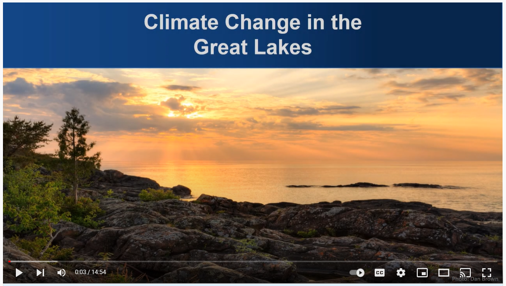
Interested in climate change at the regional level? See the Climate Change in the Great Lakes (~15 minutes). The video includes a brief overview of climate trends and impacts in the Great Lakes Region, and is provided by the Great Lakes Integrated Sciences and Assessments (GLISA) team.
 For more information, see the GLISA Summary Climate Information page.

Many of you attended the series of one hour virtual trainings presented by DNR Floodplain Program, Shoreland/River Program and Climatology staff in early 2022. Those trainings were recorded (and captioned) and many were just posted on the DNR's Land Use Program's Training and Education page (and the remaining winter 2022 trainings should be posted very soon). Whether you missed the trainings or want a refresher, they are available to all who are interested.
Warning - Updates in Progress: The Floodplain and Shoreland/Rivers programs Training and Education page will be going through a big update over the next couple months. We'll be separating out pages for the Floodplain Program, Shoreland/River Program, Water Talk newsletter, and possibly other topics. Our intent is to improve the flow and usefulness of our site, and make it easier to find the resources you are seeking.
|
By Dan Petrik, DNR, Shoreland/Rivers Program Manager
Communicating what a shoreland bluff is and where they are located are some of the most challenging tasks for local governments and the DNR. If a bluff is present on a property, shoreland standards for structure setbacks from bluffs, as well as standards for vegetation management and land alteration, apply. Here are some tips for understanding and communicating what a bluff is and how to locate them.
Updated Bluff Definition in Shoreland Ordinance
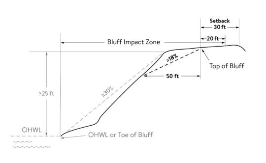
The bluff definition is complex and can be difficult to communicate. One of the best actions local governments can take is to update their shoreland ordinance definitions for bluff, bluff impact zone, toe of bluff and top of bluff, using the new graphics and text found in the updated shoreland model ordinance. The graphics are especially helpful in illustrating these definitions.
Bluff definition diagram: shows key features that must be met to verify whether a feature is a bluff, and the location of the bluff toe, bluff top, bluff impact zone and bluff setback area.
Detailed Explanation of the Bluff Definition
After updating the bluff definitions with graphics in your ordinance, the next action is to understand the process for applying the multi-step bluff and bluff-related definitions. The DNR has developed a technical guidance document that explains each step in detail, including graphics and equations, along with two examples. Working through this document will prepare you to explain shoreland bluffs with confidence, and to evaluate surveys and other elevation data to assess whether a bluff is likely to exist.
Evaluate a Slope Feature to Determine if a Bluff is Likely to Exist
Step 1: Use MnTOPO - DNR's easy-to-use tool to view, evaluate and download elevation data - to quickly assess whether a bluff is likely to exist on a particular parcel. The DNR’s Quick Guide to Analyzing Slopes with MnTOPO is useful for explaining how to conduct these initial assessments. MnTOPO uses LiDAR-derived elevation data for displaying contour lines. This elevation data can be used within the MnTOPO web application, and it can also be downloaded for use in GIS and spreadsheets. However, the MnTOPO application is not suited for locating the toe or top of bluff.
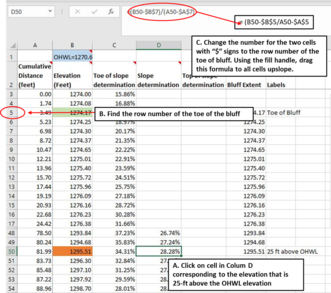
Step 2: The DNR’s Bluff Profile Tool may be helpful to analyze a specific bluff, and locate bluff features once the presence of a bluff is verified using MNTOPO. This Excel spreadsheet tool can be used to develop graphics that show a bluff, including toe and top of bluff, and is especially helpful for situations that are controversial or for public discussion. The Excel tool uses procedures and formulas that approximate the location of the toe of bluff, slope, and top of bluff. In especially difficult situations it can help demonstrate the need for a field survey. A field survey is always recommended to identify a bluff and top of bluff locations for locating structure setbacks. The bluff profile tool requires some time to learn how to use.
These and other resources on bluffs can be found at the DNR’s Bluff and Slope Protections web page.
|
|
|
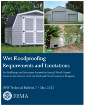 |
TB 7 discusses limitations on the use of wet floodproofing and how to evaluate the feasibility of using wet floodproofing measures for historic structures, agricultural structures and functionally dependent uses.
The major updates in TB-7 include:
- Updated to be consistent with the requirements of FEMA Policy #104-008-03, Floodplain Management Requirements for Agricultural Structures and Accessory Structures, and FEMA P-2140, Floodplain Management Bulletin, Floodplain Management Requirements for Agricultural Structures and Accessory Structures.
- Expanded discussion on best practices and measures to reduce flood damage when NFIP compliance is not required.
- Clarification of when wet floodproofing measures that require human intervention can be used.
TB 7 also discusses NFIP regulations and how building design criteria apply to new construction, substantial improvement and substantial damage.
To learn more about the eleven NFIP Technical Bulletins, visit the FEMA National Flood Insurance Technical Bulletins.
For more information on building science, visit fema.gov/building-science.
Note: Reprinted from FEMA notice.
The funds available through the Bipartisan Infrastructure Law can be viewed on the build.gov website. Water-related projects – particularly those that incorporate mitigation or resiliency into their designs – are expected to score very well for many of these programs.
On the main web page, users can scroll down and view each of the 375 funding programs available. (This is not a typo.)
Many of these are not new programs, and are instead repurposed and reinforced to accommodate this new pot of funds. Funds available for activities such as flood risk reduction, mitigation, watershed management, planning, bridge replacements, culvert enhancements, fish passage, and restoration. Many funding windows are open now, whereas others are anticipated in the near future. Now is the time to secure partnerships and preliminary designs to make your application competitive. A few suggestions for interested applicants:
|
- From the main web page, open the “guidebook data,” which is a searchable and sortable spreadsheet. This breaks down funding amounts, eligible uses, eligible recipients, application windows, cost share requirements
- Water-related funds are available through USACE, NOAA, EPA, DOT, DHS, and DOI (USFWS)
- The EPA and DOT have particularly useful websites
- Partnerships will make application more competitive
State and local officials, insurance agents, homeowners and others continue to try to better understand FEMA's new flood insurance rating system - Risk Rating 2.0 - that is effective for all new and renewing policies as of April 1, 2022.
Following are recent fact sheets and related resources:
For more information:
Flooding has been occurring in much of the state this spring. It's too early to report the full extent of the damage, but we can share some of the early reports.
Local officials and the Department of Public Safety Division of Homeland Security and Emergency Management (DPS-HSEM) staff began Preliminary Damage Assessments (PDAs) of public infrastructure damage the week of May 23, 2022. The PDAs are part of the process to determine whether a state or Presidential disaster declaration is warranted.
Wet spring in much of Minnesota
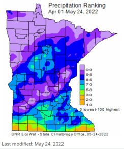
Parts of Minnesota hardest-hit by the major drought of 2021 have since become extremely wet during the 2022 spring, leading to high stream and lake levels in northern parts of the state, where some areas have experienced historic flooding.
Frequent late-winter snowstorms gave way to frequent rains, and then bouts of heavy thunderstorms.
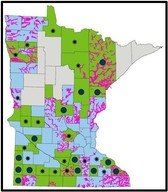
As can be seen in the weekly precipitation ranking map to the left, a corridor across central Minnesota also had extremely high precipitation through May 24.
See links to Minnesota Weekly Precipitation, Departure and Ranking maps.
|
Red River Valley flooding
Flooding peaked in the NW part of the state in late April and early May on the Red River of the North and tributaries including Red Lake River, Snake River and Clearwater River.
Many locations had river levels peak in the range of their top five historic crests. And as residents in that area know, the rivers stay high for extended periods of time, leading to extensive road closures.
The Red Lake River passed the third highest historical crest in Crookston, MN. While there were extensive sandbagging efforts and damage in the area, the many flood risk reduction projects done in the city since the record 1997 flood prevented the extensive damage to homes and businesses seen in previous record floods. Those projects involved funding from many local and federal sources, as well as over $38 million of state Flood Hazard Mitigation grants.
Record levels and lots of infrastructure damage in NE Minnesota
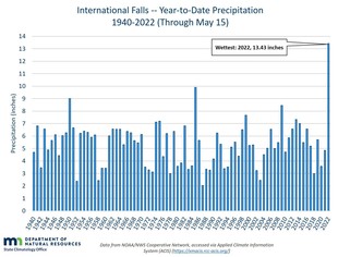
On the North Shore area in Minnesota, and the NE part of the state in general, spring rains have led to record flows and lake levels in May 2022 in many locations.
The graph to the right shows a record amount of precipitation compared to historical records for precipitation through May 15 at International Falls.
The DNR Climatology office will be doing weekly updates to a Wet Conditions Return (2022) page with much more information and useful links to lake and stream flow data.
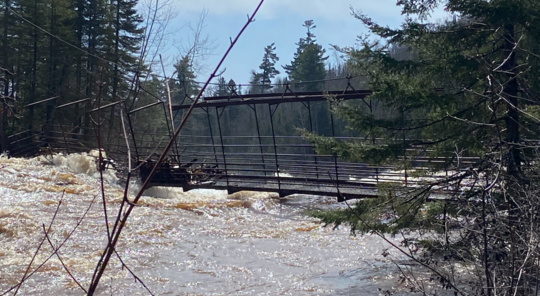
Extensive infrastructure damage occurred at Tettegouche State Park, Finland State Forest, Pat Bayle State Forest, and Grand Portage State Forest.
DNR staff report that several lakes in the Rainy River watershed reached new record elevations. The full extent of the damage is not known yet since there are many sites where staff cannot reach to assess damage to culverts and crossings due to road damage.
|
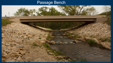
High Falls bridge at Tettegouche State Park damaged during record high flows in June 2022
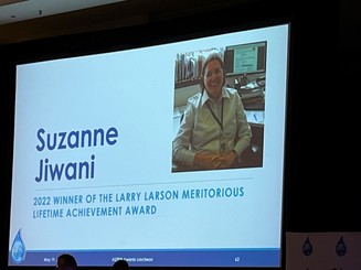
Recently retired DNR Floodplain Mapping Engineer Suzanne Jiwani was honored as a recipient of the Larry Larson Meritorious Lifetime Achievement award. The Association of State Floodplain Managers (ASFPM) held their annual conference awards ceremony on May 19, 2022. |
|
 |
By Ceil Strauss, DNR, State Floodplain Manager
Community Copies of Letters of Map Change
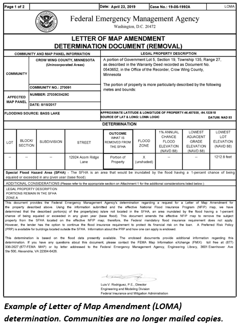
In the past, FEMA mailed communities a copy of any Letters of Map Amendments (LOMAs), Letters of Map Revisions based on Fill (LOMR-F) and other FEMA letter of map change determination documents within the community. Starting in early 2019, FEMA no longer sends copies to communities.
You can still get copies of the determinations for your community in the following ways:
1. At FEMA Map Service Center site - Select "Search All Products," enter community name and blue "Search" button, look in "Effective Products" folder for "LOMCs."
|
|
2. Email updates - Sign up to get Email updates with links to new LOMAs, LOMR-Fs, etc. - Register for FEMA Flood Map Service Center Email subscription. You’ll need to set up an account, but can set up frequency of the email updates and select the locations (i.e., community, county or state) and FEMA mapping products of interest.
|
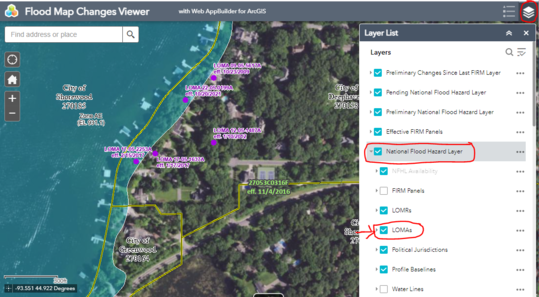
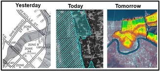
3. Search for LOMAs and LOMR-Fs on interactive map - The locations of LOMAs and LOMR-Fs are shown on FEMA's Flood Map Changes Viewer (FMCV) and FEMA's National Flood Hazard Layer (NFHL) viewer sites. See an example of the purple dots showing the locations of LOMAs in the screen shot below. Note the following:
- The LOMA layer is not a default layer in either FEMA viewer. As shown below, to turn the LOMA layer on, go to the layer list (in the top right), expand the "National Flood Hazard Layer" folder and turn on the "LOMAs" layer.
- The location of purple dots for newer cases (past 15 years or so) tend to be quite accurate, but location dots for older cases are often a ways from the structure involved.
- In the past, if the purple dots were clicked a box would come up that allowed the user to download the determination document. However, once case numbers are identified, the determination can be downloaded in the Map Service Center - Search All Products site. (Hint: If you know the case number, it is easiest to enter the case number in the upper right Product ID box.)
Sample view in FEMA's Flood Map Changes Viewer. Purple dots show LOMA and LOMR-F locations.
Note: This is an update of a June 2019 Water Talk article.
FEMA Region 5 staff (based in Chicago, IL) are continuing their monthly one hour virtual training series. They are FREE!
It's not too late to register for many training topics!
Upcoming "Managing your Community's Floodplain" monthly series dates and topics:

Note: All held 9-10 am Central Time.
-
June 23, 2022: NFIP Fundamentals for New Floodplain Managers (Repeat of Topic #3 on March 30, 2022); Registration Link
-
Topic #6 June 29, 2022: NFIP Compliance; Registration Link
-
Topic #7 July 27, 2022: Managing FIRM Map Changes and Community Acknowledgement; Registration Link
-
Topic #8 August 31, 2022: Coastal Resilience and Floodplain Management; Registration Link
-
Topic #9 September 28, 2022: Resolving Potential Violations; Registration Link
-
Topic #10 October 26, 2022: Higher Standards
-
Topic #11 November 30, 2022: Basement Flooding Mitigation
-
Topic #12 December 14, 2022: No Adverse Impact
|
Important Dates to Note:
(since March 2022 Water Talk and upcoming in next couple months)
|
|
 |
Preliminary Maps:
- April 29, 2022: Wright County (revised panels)
- June 2022: Pipestone, Rock, and St. Louis Counties
- July 2022: Chippewa, Dodge, Le Sueur, and Morrison Counties
Local Officials Meetings & Open Houses*
- Itasca County: Local Official Meeting - March 31, 2022; Public Open House - April 12, 2022
- Otter Tail River HUC8 Discovery Kickoff for local officials - March 30, 2022
- Rum River HUC8 Discovery Kickoff for local officials - March 31, 2022
- Twin Cities Mississippi River HUC8 (portions of Anoka, Carver, Dakota, Hennepin, Ramsey, and Washington Counties) - Local Official Flood Risk Review Meetings:
- Coon Creek Watershed - Summer 2022
- West Mississippi Watershed - Summer 2022
- Elm Creek Watershed - Fall 2022
- Vadnais Lakes Watershed - Fall 2022
- South Washington Watershed - Fall 2022
- Wright County - Local Official Meeting & Public Open House - Summer 2022
*Most meetings and open houses expected to be virtual until further notice.
90-Day Appeal Periods
- Carlton County - 3/31 to 6/29/2022
- Stevens County (panels) - 2/5 to 5/16/2022
Letters of Final Determination (LFDs)
- Nicollet County - April 13, 2022
- Lake of the Woods County - April 27, 2022
- Koochiching County - May 17, 2022
- Pennington County - June 2022 (anticipated)
Effective (6 months after LFD date)
- Rice County (Zumbro watershed panels) - April 6, 2022
- Lyon County (levee panels) - Sept. 15, 2022
Additional Map Update Information:
|