|
By Ceil Strauss, DNR, State Floodplain Manager
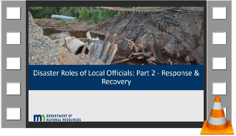 Opening view in Disaster Roles of Local Officials: Response and Recovery video
DNR recently completed two videos with a higher level discussion of roles and responsibilities for local officials, and directing to lots of helpful resources.

Viewer Hint: Select the "Show More" below the video to see links to more information and time stamps in the videos.
|
There are also links to the videos and related resources on DNR's Flooding Preparation, Response, and Recovery page.
For more information on topics covered in the videos, or floodplain management in general, please contact DNR’s Floodplain staff. You can also suggest future video topics.
The joint MnAFPM / WAFSCM annual conference is being held Nov. 3-5, 2021, in LaCrosse, Wisconsin. You won't want to miss all the great presentations, workshops and opportunities to learn from each other, so register now!
- Nov. 3, 2021: workshops and tour
- Nov. 4, 2021: conference
- Nov. 5, 2021: CFM exam offered
|
By Ceil Strauss, DNR, State Floodplain Manager
Since MNTOPO was introduced in 2013, this easy-to-use web application has been a favorite site for many of our Water Talk readers for viewing, printing and downloading LiDAR-derived elevation data. However, some readers may not be aware of this useful tool, and many of our regular MNTOPO users may only be scratching the surface of its suite of functionality.
To access MNTOPO: Go to DNR's MNTOPO site to learn more about LiDAR and the supporting data, and then use the "Proceed to the MnTOPO viewer" button.
Our March 2014 Water Talk (the inaugural GovDelivery version) had an introduction to MNTOPO (scroll down to the "Cool Tools and Sites" article), but there have been improvements and additions over the years. So read on to learn about the basic features.
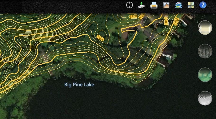 Sample MNTOPO view using imagery background (and showing the other potential backgrounds - street view, color shading relief, and gray shading relief)
Basic view
If an address or city is entered in the “Quick Search” box in the upper left, it will zoom down to the most detailed 2-foot contour view.
The Basemap icon gives options for the background, including roads (default), imagery, color terrain and black & white terrain.
Other basic functions include the print and help options.
|
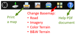
Layers available
Select the layers icon to see a pop-up box with the following layers:
1. Contours: Contours can be turned off and on.
2. LiDAR Flight Lines: Select a flight line to see date of the LiDAR flight.
3. FEMA Flood Data:
- The bar at the bottom adjusts the transparency of the flood data layers.
- The “modernized” 1% annual chance (100-year) floodplain layer exists in the counties with Digital Flood Insurance Rate Maps (DFIRMs) or new FEMA maps created since 2003.
- The “unmodernized” 1% annual chance floodplain layer (aka Q3) is a less accurate digitization of floodplain boundaries completed with post disaster funding in the counties that had disaster declarations in 1993 (counties with subsequent DFIRMs are represented in the “modernized” layers).
Note: Flood data layers cannot be seen at the most detailed scale, so zoom up a level.
|
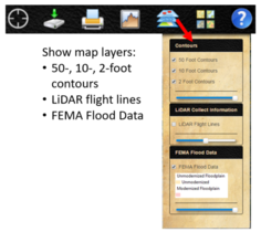
Download LiDAR Products
Users can select an area and download a variety of LiDAR products, including: contours, one or three meter DEMs, hillshade, raw LAS files, bare earth points, building footprints and hydro breaklines.
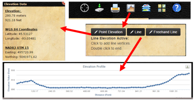
Elevation Points or Profiles
Select the elevation icon (looks like a graph); the pop-up box provides the option to select points or profile lines.
Point elevations: select a spot on the map to get the elevation and latitude/longitude.
Profile Line: Select the beginning and ending point locations for a line on the map to create an immediate profile display. The profile data points can be downloaded and reformatted if you'd like to customize the profile.
|
 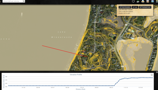 Example profile that can be used to evaluate whether a steep area is officially a bluff subject to Minnesota Shoreland Management regulations
Recent survey of MNTOPO users
As noted in the 9/7/2021 special MNTOPO edition of Water Talk, a short survey has been available during September and a portion of October 2021 to obtain input on how MNTOPO is used, and collect ideas for improvements. We've had a fantastic response, with over 900 taking the survey so far, and over a third of the respondents providing specific comments. Additionally, over 200 indicated willingness to be involved in future input and follow up. DNR staff knew MNTOPO is a very helpful tool, but we were pleasantly surprised to see the level of interest and support to keep this tool functional, and potentially make improvements.
If you missed the survey, you can still take the short, two-minute survey (through October 2021) to let us know why you use MnTOPO and how it can be improved.
By Dan Petrik, DNR, Shoreland and River Manager
Help your elected and appointed officials make informed and better decisions when it comes to shoreland development. These officials rely on staff to guide them through land use applications in shoreland. While this will continue to be the role of local staff, DNR’s new shoreland training for officials can help support your work by building understanding of why and how shoreland protections are important to your community.
Content for One Hour Training (Can be Customized)
Training topics include shoreland basics, variances in shoreland and higher standards. The training can be customized to fit local development issues and concerns. Trainings are virtual and designed for one hour – 45 minutes of presentation with 15 minutes for Q & A. Multiple trainings that build on each other are a good way to learn about shoreland in smaller increments over time.
Should Your Community Do This Training?
|

Trainings are most effective when all of a community’s elected and appointed officials can attend during a special training workshop. Discussion between elected and appointed officials can be a powerful learning experience for everyone. Because these workshops are virtual, local staff are needed to facilitate in-person questions and discussion with DNR staff from remote locations.
|
This training is especially helpful for communities with new officials and those communities where there is a poor understanding of shoreland requirements and their protective value or communities approving variances that significantly deviate from shoreland standards.
How Can You Bring This Training to Your Community?
If you think your elected and appointed officials would benefit from this training, discuss it with them at one of their meetings. In order to get the most out of the training, it’s important that your officials have a genuine interest in learning about shoreland protections. If there is an interest, contact your DNR Area Hydrologist who will work with DNR training staff to plan for and schedule the training.
By Ceil Strauss, DNR, State Floodplain Manager
In the Spring 2021 Water Talk article Risk Rating 2.0 Is Coming - What We Know So Far, we discussed how the previous - or legacy - flood insurance rating system worked, what's staying the same, and some highlights of how things are changing with the new Risk Rating 2.0 (RR 2.0) methods.
As RR 2.0 is rolling out, we are confirming some program information, but more questions are surfacing on other details of the new premium rating system.
Below are answers that we know for some of the Frequently Asked Questions.
-
Oct. 1, 2021 - PHASE I: All new policies start using Risk Rating 2.0 premiums; renewals of existing policies may use Risk Rating 2.0 (since many will see premium decreases)
-
April 1, 2022 - PHASE II: Renewal of all existing policies use Risk Rating 2.0
Are Flood Insurance Rate Maps (FIRMs) still used under RR 2.0?

- FEMA's Flood Insurance Rate Maps (FIRMs) will continue to be used for Floodplain Management (local floodplain management ordinances), and to determine Mandatory Purchase requirements. Note: If the building is in or touching a Zone A or Zone V (the Special Flood Hazard Area) on the FIRM, and the owner has a federally backed loan, the lender must require flood insurance.
- The flood zones and Base Flood Elevations on the FIRM will no longer be used for determining flood insurance rates.
On a related note: Some floodplain managers have suggested the FIRMs be renamed Flood Information and Risk Maps!
Are Elevation Certificates (ECs) still used to rate policies?
|
- Under the legacy system, an EC was required to rate policies for post-FIRM structures in the SFHA, i.e., in the mapped higher risk areas, but not in the medium and lower risk Zone X areas.
- Under RR 2.0, an EC is not required to rate a policy. HOWEVER, an EC can be used in ANY Zone if it will result in a better rate. Many agents with larger flood coverage portfolios have noted the ECs help - sometimes significantly - in a high percentage of quotes.
|
How are rates changing, in general?
- Policies are no longer being rated based on whether the structures are "in" or "out" of the FEMA map zone. Now policies in all zones will be rated based on how high the "First Floor Elevation" is above the "Lowest Adjacent Grade," distance from flooding sources, construction type, building values, and other factors.
- For existing policies, the statutory cap for annual price increases (18 percent for primary residential, 25% for others) stays in place. If the "full risk rate" is higher, the rate will continue on a glide path until it reaches the full risk rate.
- Most new policies go immediately to full risk rates.
Will I pay more or less under RR 2.0?
It depends!
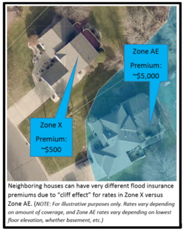
Under the legacy system, there has been a "cliff effect," with neighboring properties paying very different rates based on whether they were in or out of the SFHA. In general, under RR 2.0:
- Rates will likely go up for the building just outside the SFHA
- Rates will likely decrease for the building just inside the SFHA
First year increases versus Full Risk Rates:
In the Spring 2021 Water Talk article, Risk Rating 2.0 Is Coming - What We Know So Far, we shared the FEMA summary for Minnesota. This showed 29% of existing policies would have decreased premiums, 65% would have increases of 0-$10/month (0-$120/year) and 7% would have increases of more than $10/month ($120/year).
|
However, it was not adequately emphasized that those changes are just for the first year, and the impacts were buffered by the statutory caps for the annual price increases.
Since 65-70% of Minnesota policies have traditionally been the discounted Preferred Risk Policies (PRPs), those premiums have been in the $600/year range and lower (depending on the amount of coverage) for primary residential structures. So the 18% increase cap for primary residential properties meant that most of the PRP policies had a first year increase of less than $120. Most of those policies will be going up.
The magnitude of the increases will depend on a number of factors measuring the flood risk for that structure. While we are learning more about what risk factors have the biggest impacts, and which risk reduction methods (e.g., greater freeboard, elevating utilities, and flood vents) can help, the details are currently unknown. Unfortunately, what we know is the full risk rates can be significantly higher.
For more information:
The Office of the Flood Insurance Advocate (OFIA) recently produced four videos to help explain frequently misunderstood concepts of the National Flood Insurance Program (NFIP) to customers. These new videos explain commonly misunderstood topics in a way that is straightforward and informative, with helpful graphics, each in less than three minutes!
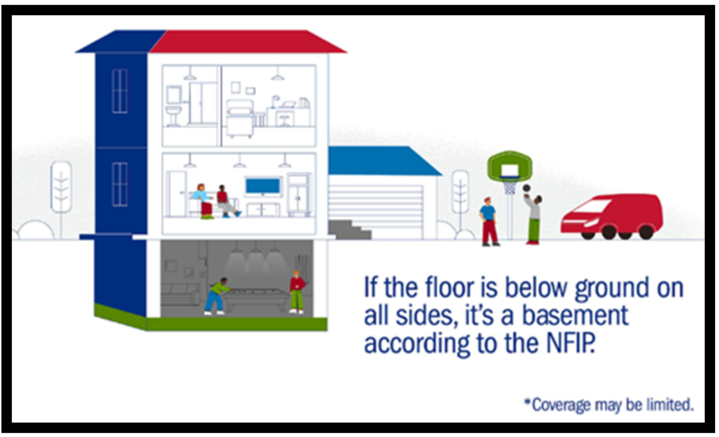 Image from FEMA's OFIA "Basement" video released September 2021
The following videos are available:
-
The Claims Process: This video explains the NFIP claims process. It includes:
-
Basements: This video explains how the NFIP defines basements. It includes:
- NFIP definition of a basement
- Types of below-ground spaces which are considered a basement
- Types of items and basement furnishings which have coverage
-
Flood Risk: This video explains the tools and considerations for assessing flood risk. It includes:
- An introduction to FEMA’s Flood Insurance Rate Map (FIRM) and flood zones
- Considerations for homes outside of high-risk areas
- Urban flooding risks
-
When Flood Insurance is Required: This video explains when flood insurance is required vs. when it is simply recommended. It includes:
- An introduction to Flood Insurance Rate Maps (FIRMs) and Special Flood Hazard Areas (SFHAs)
- Mandatory purchase requirements for federally backed mortgages
- Insurance’s effect on eligibility for future disaster assistance
- Reasons to insure properties when there is no requirement
Editors note: This article is adapted from FEMA's Flood Insurance Advocate Video Project webpage.
The Groundwater Atlas of Winona County was recently published by the DNR. The web page includes links to the report, 2 map plates, and GIS files that cover groundwater flow patterns, chemistry, and sensitivity to pollution. This is Part B of a series which expands Part A, the geologic atlas previously published by the Minnesota Geological Survey. See below a summary of the contents.
Much of Winona County geology is karst terrain formed by water dissolving the underlying bedrock. This allows rapid water movement between the surface and the aquifers. Karst usually contains sinkholes, caves, and springs, but rapid connections can exist even where karst features are absent on the land surface. The pollution sensitivity of aquifers is generally very high in karst areas and moderate to high along the Mississippi River valley and in valley bottoms.
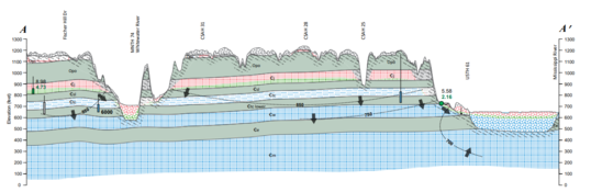 Example hydrogeologic cross section from new groundwater atlas for Winona County
Bedrock aquifers are the primary source of water for drinking and for streams. The bedrock is close to the land surface and is only protected by thick overlying sediment in valley bottoms. Groundwater in the county generally has elevated chloride and nitrate with high pollution sensitivity in aquifers above the protective St. Lawrence aquitard. Below the St. Lawrence recharge is slower, resulting in less contamination and less human impact to groundwater. Springs commonly have elevated levels of both chloride and nitrate, even if located below the St. Lawrence.

The National Flood Insurance Program (NFIP) has had many short extensions since the last five-year extension that expired Sept. 30, 2017. The latest extension was set to expire Sept. 30, 2021. On Sept. 30, the President signed legislation passed by Congress that extends the NFIP’s authorization to Dec. 3.
FEMA reports that they and Congress have never failed to honor the flood insurance contracts in place with NFIP policyholders. Should the NFIP’s authorization lapse, FEMA would still have authority to ensure the payment of valid flood claims with available funds. However, FEMA would stop selling and renewing policies for millions of properties in communities across the nation. Nationwide, the National Association of Realtors estimated in 2017 that a lapse might impact approximately 40,000 home sale closings per month.
|
Interested in joining the DNR Division of Ecological and Water Resources (EWR) team?
There are two current/imminent opportunities:
-
Dam Safety Unit: Posting for a vacant Engineer Senior position. Closing date is November 3, 2021.
-
Floodplain Mapping Program: Coming soon! Modeling/mapping position in the floodplain modeling and mapping group is expected to be posted in the near future. Please check the Careers in Minnesota site for updates
Important Dates to Note:
(since July 2021 Water Talk)
|
|
 |
Preliminary Maps
- July 30, 2021: Itasca County (revised)
- Sept. 30, 2021: Lincoln, Stevens (revised panels), and Waseca Counties
- October 2021: Watonwan County (revised panels)
Local Officials Meetings & Open Houses*
- Carlton County
- Local Official Meeting - Aug. 19, 2021
- Public Open House - Sept. 23, 2021
- Itasca County
- Local Official Meeting - Nov. 9, 2021
- Public Open House - Nov. 18, 2021 (5-7 pm)
- Twin Cities Mississippi River HUC8 (portions of Anoka, Carver, Dakota, Hennepin, Ramsey, and Washington Counties) - Local Official Flood Risk Review Meetings:
- Coon Creek Watershed - December 2021/January 2022
- Elm Creek Watershed - December 2021/January 2022
- West Mississippi Watershed -December 2021/January 2022
*All meetings and open houses expected to be virtual until further notice.
90-Day Appeal Periods
- Blue Earth County - 7/29 to 10/26/2021
- Koochiching County - 9/3 to 12/2/2021
- Lake of the Woods - 8/11 to 11/9/2021
- Lyon County (panels) - 7/8 to 10/5/2021
- Nicollet County - 7/29 to 10/26/2021
- Olmsted County (panels) - 7/27 to 10/25/2021
- Pope County - 7/20 to 10/18/2021
Letters of Final Determination (LFDs)
- Rice County (Zumbro watershed panels) - Oct. 6, 2021
Effective (6 months after LFD date)
- Cottonwood County - Sept. 24, 2021
- Yellow Medicine County - Oct. 7, 2021
Additional Map Update Information:
|