|
June 1, 2021
By Ceil Strauss, DNR, State Floodplain Manager
FEMA is about to start rating flood insurance premiums in a new way. Work on Risk Rating 2.0, and transitioning to the new rating methodology, has been in the works for many years. It was originally going to start phasing in back in October 2020, but got delayed. But it's really coming now!
What are changes coming?
Some of the overall goals for the new rating methodology include:
- Reducing complexity:
- Eliminating Elevation Certificate (ECs) requirement (can use if better rate)
- Simplifying information needed (will use different rating factors)
- Promoting investment in mitigation:
- Expanding mitigation credits (e.g., for elevated Machinery & Equipment)
- Expanding CRS discounts (discounts for all policies)
- Addressing inequalities:
- Leveraging more location-specific information
- Reflecting prior claims
- Factoring in replacement costs
- Not charging higher rates for first $60,000 of coverage
See more about the overall goals of Risk Rating 2.0 and example of the "cliff effect" that leads to one example of inequalities in rating in the December 2019 Water Talk article "Risk Rating 2.0 is Coming - But Not Yet . . ."
What the changes mean for Minnesota
Based on FEMA analysis of Minnesota's current flood insurance policies, we expect the following changes in premiums:
-
29% (3,094 policies): Immediate decreases
-
65% (6,760 policies): $0 - $10 per month ($0 - $120 per year) increases
- 4% (397 policies): $10 - $20 per month ($120 - $240 per year) increases
- 3% (292 policies): Greater than $20 per month ($240 per year) increases; Note: Most of the policies in this group are for non-residential buildings
- See Minnesota's profile. Note: More detailed summaries at the county and zip code level just became available on May 28, 2021!
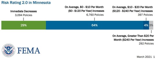 Summary of FEMA Evaluation of Risk Rating 2.0 Premium Changes for Minnesota.
Timing For the transition to Risk Rating 2.0:
-
April 1, 2021 - Initial updates on how Risk Rating 2.0 will work
-
Aug. 1, 2021 - Agents may begin quoting premiums with Risk Rating 2.0 rates (Draft Flood Insurance Manuals expected to be released
-
Oct. 1, 2021 - PHASE I: All new policies start using Risk Rating 2.0 premiums; renewals of existing policies may use Risk Rating 2.0 (since many will see premium decreases)
-
April 1, 2022 - PHASE II: Renewal of all existing policies use Risk Rating 2.0
What's staying the same?
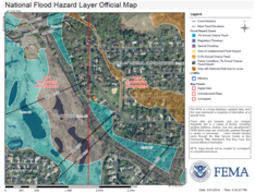
- FEMA's Flood Insurance Rate Maps will continue to be used to determine Mandatory Purchase requirements and for Floodplain Management (local floodplain management ordinances).
- Only those in communities participating in the National Flood Insurance Program (NFIP) are eligible to purchase the federally backed NFIP flood insurance.
- Letters of Map Amendments (LOMAs) and Letters of Map Revisions (LOMRs).
- Increased Cost of Compliance (ICC).
- Discounts for those in Community Rating System (CRS). Note: Discounts will apply to all map zones, so even more policies get discounts.
- Limiting annual premium increases (e.g., 18% per year on individual rates).
- Can transfer better rates by assigning flood insurance policy when property changes ownership.
|
Reminder of current rating factors
Since flood insurance became available through the National Flood Insurance Program over 50 years ago, the main factors affecting premiums have included:
-
In SFHA? Is the structure in the Special Flood Hazard Area (SFHA), i.e., one of the higher risk A or V Zones, on a FEMA Flood Insurance Rate Map (FIRM)?
-
Pre or Post FIRM? When was the structure built?
-
Pre-FIRM: If it was built before the first FIRM, rates have been subsidized and a FEMA Elevation Certificate was not required
-
Post FIRM: If it was built after the first FIRM, a FEMA Elevation Certificate is required, and it's rated based on actual elevations
-
LFE minus BFE: How does the lowest floor elevation (including basement or crawl space) compare to the Base Flood Elevation (BFE), or the 1% annual chance flood elevation (commonly call the "100-year flood" elevation)?
What are the new rating factors?
The current flood insurance premium ratings (for newer buildings) rely mainly on the FEMA map zone, and lowest floor elevation versus the Base Flood Elevation. The Risk Rating 2.0 rating engine will consider many different factors, including:
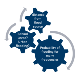
- Distance to flooding source.
- Flood type (riverine or Great Lakes).
- Building replacement cost.
- Building foundation and construction type.
- First floor elevation.
- Ground elevation (lowest adjacent grade).
- Considering urban flooding and whether behind levee.
- Probability of damage for more flood frequencies below and above 1% annual chance flood elevation, including up to 10,000-year flood (depending on data available in that area).
|
For More Information
Editor's note: As more details are known, future articles will highlight aspects of most interest in Minnesota.
Everyone is joyfully looking forward to summer after a long Minnesota winter and the easing of Covid-19 restrictions. We love our water, colorful flowers, garden vegetables, shade trees, and green lawns. Water rates are generally affordable, but we still don’t want to be wasteful of our most precious resource.
What Can You Do to Save Water?
What can everyone do to save water in the summertime? Visit the Department of Natural Resources (DNR) Water Conservation webpage for helpful ideas for saving water this summer!
Targeting outdoor landscaping and irrigation offers the most water savings. In peak summer months, as much as 50 percent of a utility’s water use can be for irrigating turf. Typically, a homeowner only needs to water their lawn when the grass does not spring back when walked on.

Efficient lawn watering:
- Water landscapes and lawns during the early morning, when it is still cool.
- Lawns need about 1 inch of rain or water per week. Deep soaking is better for roots than frequent shallow watering.
- Water your lawn infrequently, one time or less per week, assuming no rainfall has occurred.
- Set your mower at 3 to 4 inches to promote deeper roots.
- Consider lawn grasses that don’t need as much water, like fine fescues.
|
Residential automatic irrigation leads to over-watering by hundreds of gallons through “setting and forgetting.”
- Turn off automatic irrigation completely and use it only during extended dry spells.
- Soil moisture sensors prompt irrigation only when needed. Most cost between $120 and $160. They rarely require replacement.
- Time to upgrade your lawn irrigation controller? Consider a smart irrigation controller to save water.
- Many Minnesota cities have odd/even watering restrictions during the summer months to reduce consumption. It is best to water deeply and infrequently (at most once or twice a week during dry months).
To learn more about lawn irrigation, see:
For vegetable and flower gardens consider using rain barrels, or reuse dish water or other household greywater. The long term solution to landscape irrigation is to convert 5-25% of your turf to native and drought-resistant plants that also provide pollinator and wildlife habitat. Once established, native wildflowers and grasses require no irrigation or fertilizing, save water and maintenance time and provide visual interest year-round. See the DNR webpage for a guide How to Use Native Plants for Landscaping
By Ceil Strauss, DNR, State Floodplain Manager
|
The National Flood Insurance Program’s (NFIP) Community Rating System (CRS) is a voluntary incentive program that recognizes and encourages community floodplain management activities that exceed the minimum NFIP requirements. As a result, flood insurance premium rates are discounted to reflect the reduced flood risk.
|
|
Benefits of CRS
Traditionally, there have been two main reasons to consider joining the Community Rating System (CRS):
1. A higher level of floodplain management that leads to reduced flood damage risk (to lives, property, and economic activity) in your community, and
2. Save money on flood insurance premiums for landowners/citizens with structures in the higher risk areas.
|
But once the new Risk Rating 2.0 premium rating methodology is in place, reason #2 will be even better! Discounts will apply to ALL policies, not just those in the higher risk zones. Since about 65% of Minnesota flood insurance policies are the lower risk zone Preferred Risk Policies, they currently do not receive the discounts.
|
How are Flood Insurance Premium Discounts for CRS Communities Calculated?
Flood insurance premium rates in Community Rating System communities are discounted in increments of 5%. A Class 10 community is not participating in the CRS and receives no discount. A Class 9 community receives a 5% discount for all policies in its Special Flood Hazard Areas, a Class 8 community receives a 10% discount, all the way to a Class 1 community, which receives a 45% premium discount.
Policies in the higher risk Special Flood Hazard Areas (SFHAs) get the full discount, while some structures that have Non-SFHA policies (but that have a higher level of risk, including "grandfathered" or "newly mapped" policies) get a discount of 5% or 10% (in class 6 and higher communities). Currently, the most common policy type in Minnesota - the Preferred Risk Policy for structures in Non-SFHA - do not receive any discount.
Classifications are based on 19 creditable activities, organized in four categories:
- Public Information
- Mapping and Regulations
- Flood Damage Reduction
- Warning and Response
In Minnesota, the communities with the highest CRS rating are Class 5, meaning a 25% SFHA and 10% non-SFHA discount. These are usually communities that have done extensive flood damage reduction projects and preserved significant open space.
|
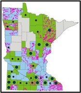
Current Minnesota CRS Communities
Note: The follow table shows the current classes and discounts for Minnesota communities. As Risk Rating 2.0 becomes effective, the SFHA discount percentage will apply to ALL policies.
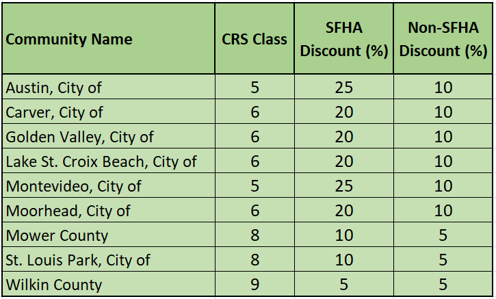 Minnesota CRS communities as of October 1, 2020
Many More Buildings Get Discounts with New Risk Rating 2.0
The new FEMA flood insurance premium methodology, that starts to phase in October 1, 2021, will no longer include the Preferred Risk Policy (PRP) option. All structures will be rated based on more equitable factors of risk. Many Minnesota communities that have many flood insurance policies, but where the policies are mainly PRPs, did not see the benefit of joining the CRS since so few of the policies were eligible for a CRS discount.
As the new Risk Rating 2.0 rating methodology phases in, all the policies will be eligible for the CRS discounts their community has earned!
Is it difficult to qualify for the CRS?
In most cases – No! If a community administers the state model ordinance they often have enough points to be a Class 8 or Class 9 community. The best way to start the process is to do a bit of background reading, and then contact the ISO/CRS contact serving Minnesota, Melissa Mitchell or Minnesota State Floodplain Manager Ceil Strauss. They can provide a community-specific “What If” document that shows the policy count and potential CRS discount amounts, which can be very helpful for a community considering CRS to see.
For More Information
Community Rating System: A Local Official’s Guide to Saving Lines, Preventing Property Damage and Reducing the Cost of Flood Insurance (FEMA B 563; 2018; 12 pages).
FEMA National Flood Insurance Program Community Rating System (NFIP/CRS) (main website).

The Metropolitan Council provides essential services, including water and wastewater management, in the Twin Cities metropolitan area. They recently updated a video to teach youth about water resources.
|
Wastewater Treatment for Kids provides a simplified look at wastewater treatment by taking you on a tour of the process at the Metropolitan Wastewater Treatment Plant in Saint Paul. Join a heron, a duck and a frog to learn more about our water resources in the Minneapolis-Saint Paul metro region.
You’ll learn about:
- The water cycle
- How we use water from the environment
- How communities and the Met Council collect wastewater from your home, school, or work
- How the Met Council’s largest wastewater treatment plant, the Metropolitan Wastewater Treatment Plant, cleans that water so it's safe to return to the environment!
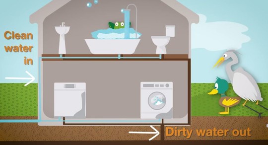 Clip from Wastewater Treatement For Kids video
For more information
Contact Kate Nyquist at Met Council (or 651-602-1268).
Editor's note: Excerpts of this article from April 19, 2021 Metropolitan Council Newsletter.
Although Minnesota is trending toward wetter conditions, droughts are always going to be a part of the climate. Drought is defined as a shortage in precipitation relative to normal climatic conditions over an unspecified time interval. Drought persistence can lead to agricultural impacts and hydrologic imbalances, affecting soil moisture, groundwater supplies, lake levels and stream flows. It is one of the only naturally occurring hazards, which can simultaneously affect agriculture, public utilities, forestry, and tourism in every county of our state.
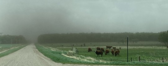 Photo taken May 25, 2021 by DNR staff near border of Pennington and Red Lake Counties. The clouds of dirt and dust blowing around (and loss of top soil), due to winds of 25-30 mph with gusts of 50 mph, is a good example of the impacts of extremely dry conditions..
What Should We Do to Prepare?
What should cities, counties, business, environmental organizations and individuals do during a drought to protect our water resources? First, monitor your local water situation. If you are responsible for water supplies for your city or business, make sure your well/water meters are calibrated and in good working order. If water level equipment is installed, keep daily records and report any concerns to your local DNR hydrologist.
Weekly Drought Monitor Map
Alternatively, check the weekly statewide Drought Monitor map. This resource has established categories of drought from abnormally dry (D0), to moderate drought (D1), severe drought (D2), extreme drought (D3) and exceptional drought (D4). The Drought Monitor website also identifies historically observed impacts on soil moisture, fire danger, surface water levels and water temperature for each drought category.
 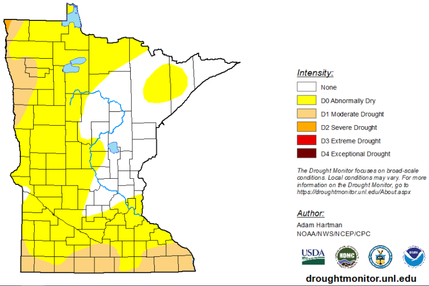 May 18, 2021 U.S. Drought Monitor for Minnesota.
Water Conservation and Efficient Use
During dry periods like we are experiencing now, the most effective measure is water conservation and efficient use. Voluntary water conservation actions can be taken by everyone and encouraging residents and businesses to do their part can help. In addition to promoting water conservation, local governments can establish water efficiency ordinances, set fines for wasting water, set tiered water bill rates, or during significant droughts set limits on usage. For example, cities or counties may restrict when customers can use water for lawn watering, car washing, swimming pools, and other less essential water use. Minnesota cities serving over 1,000 people should reference their Local Water Supply Plan for guidance. Public water suppliers should provide early notice about emerging drought conditions and any potential restrictions.
As we have seen from the western states, during abnormally dry periods it is good to monitor the Statewide Fire Danger and Burning Restrictions maps and implement any local restrictions that may be necessary.
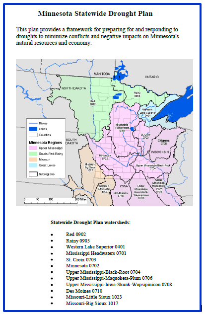
Statewide Drought Plan
|
The state of Minnesota does have a Statewide Drought Plan that includes a staged approach for implementing drought response actions. Once a Drought Warning Phase is reached, a Drought Task Force is convened with key state, federal and local agencies including the departments of Agriculture, Health, Public Safety, Transportation, UMN, Corps of Engineers, Association of Counties, and others. As outlined in the Drought Plan relevant water users and public water suppliers will be notified to begin implementing appropriate water use restrictions. The Governor is empowered to declare a critical water deficiency by executive order (103G.291 Subd. 1).
Cover of 2009 Minnesota Drought Plan to right.
|
|
 |
Other Resources
The Midwestern Regional Climate Center has many resources including drought assistance programs, educational materials, and drought preparedness links. Water conservation is a good habit all the time for everyone, but it becomes essential during abnormally dry conditions and drought.
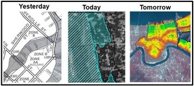
Past, scheduled, and anticipated dates since March 2021 Water Talk |
|
 |
Preliminary Maps
- Carlton County - May 28, 2021
- July 2021: Itasca (revised), Stevens (revised), Watonwan (revised), and LeSueur Counties (anticipated)
Local Officials Meetings & Open Houses*
- Blue Earth County - Mankato Open House - June 10, 2021, 5-7 pm
- Twin Cities Mississippi River HUC8 (portions of Anoka, Carver, Dakota, Hennepin, Ramsey, and Washington Counties) - Local Official Flood Risk Review Meetings:
- Shingle Creek WD - 4/1/21 am
- Minnehaha Creek WD - 4/15/2021 pm
- Coon Creek WD - July 2021
- Elm Creek WD - July 2021
- West Mississippi WD - July 2021
*All meetings and open houses expected to be virtual until further notice.
90-Day Appeal Periods
- Rice County (panels) - March 3 to June 2, 2021
Letters of Final Determination (LFDs)
- Cottonwood County - March 24, 2021
- Yellow Medicine County - April 7, 2021
Effective (6 months after LFD date)
- Cottonwood County - Sept. 24, 2021
- Yellow Medicine County - Oct. 7, 2021
Additional Map Update Information:
|