|
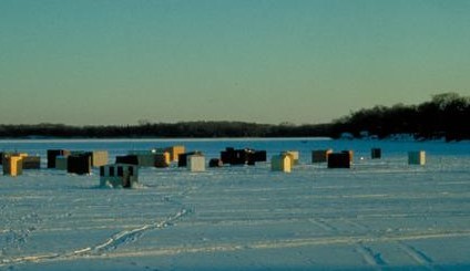
Climate change is chipping away at Minnesota’s winter ice, according to new data released today by the Minnesota Pollution Control Agency (MPCA) and Department of Natural Resources (DNR). On average, the state has lost 10 to 14 days of lake ice over the past 50 years, with some popular, iconic lakes losing almost three weeks of ice — impacting lake and fish health, outdoor sports enthusiasts, and business owners.
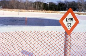
Since 1967, ice-in dates have been about nine days later on average, while ice-out dates have been about four to five days earlier. That means two weeks of lost ice coverage for ice fishing, cross-country skiing, snowmobiling and other winter activities on Minnesota lakes. Each year, Minnesotans and visitors spend millions of dollars on winter recreation and a shortened lake ice season threatens the revenue of businesses that support these cold-weather traditions.
“Shorter lake ice seasons, caused by climate change, are threatening some of Minnesota’s most cherished traditions,” said MPCA Commissioner Katrina Kessler. “We must take bold action to mitigate the devastating effects of climate change — for the sake of our lakes, our economy, and to save winters as we know them in our state.”
|
The average loss of ice duration on popular lakes for winter recreation include:
- Lake Bemidji, Beltrami County: -18.9 days
- Lake Waconia, Carver County: -14.8 days
- Lake Itasca, Clearwater County: -14.0 days
- Lake Washington, Blue Earth and Le Sueur County: -13.7 days
- Detroit Lake, Becker County: -9.5 days
*Ice seasons and data vary year to year; the above data reflect averages.
Compared to 50 years ago, the average July-August surface water temperatures on Minnesota lakes are 3.0 – 3.9 degrees warmer. This rise has serious ramifications for our natural lake habitats. Aside from causing shorter ice seasons, rising water temperatures contribute to increasing reports of toxic blue-green algae blooms, which thrive in temperatures 75 degrees and warmer. Additionally, temperature is a driving force in every aspect of the health of our fish populations, including reproduction, growth, and survival. DNR has tracked trends for many fish species over the last 30 years and found that numbers are clearly changing, with declines in some important cold-water species.
|
“Minnesota’s ice data reflects the changes that Minnesotans who enjoy our outdoors have already felt,” said DNR Commissioner Sarah Strommen. “As water and air temperatures continue to rise, we can expect to see more shifts in our native fish species, lake health, and winter recreation. DNR and MPCA have been working on climate strategies, but we know further bold action is needed to mitigate the effect of climate change and help preserve the valuable resources that make Minnesota an enviable place to live.”
Learn more about forward-thinking initiatives and policies led by state agencies to help communities across Minnesota prepare for and adapt to climate change.
View data on ice duration trends
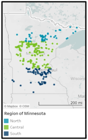
MPCA has interactive graphs showing lake ice durations over many years on their View the data on climate impacts page. The graph below shows the overall trend of lake ice duration (in days) from 1967 to 2021, with the colors representing Minnesota lakes in the north, central and south portions of the state.
You can chose to evaluate trends in the three regions of the state, or for many individual lakes, over a period of record of your choice.
|
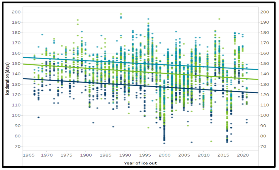 Ice duration (in days) from 1967 to 2021 shows shorter ice seasons in all parts of Minnesota
Many volunteers help make this analysis possible

Remember that DNR and MPCA would not be able to share these valuable lake trend records without the irreplaceable efforts of the hundreds of volunteers who record water level readings, record dates ice forms and departs, collect water samples and record other water quality indicators.
We can't do this work without these dedicated volunteers!
|
Note: Article adapted from MPCA article and website information.
By Ceil Strauss, DNR, State Floodplain Manager
Back by popular demand!

A series of one hour virtual trainings on floodplain and shoreland management topics is coming January through early March 2022. The timing will be the same as we had during our Spring 2021 series, with trainings offered 1-2 pm on Mondays, and 9:30-10:30 am on Wednesdays.
Use the "Register" link next to each training to sign up. (Reminders and links to the training will be emailed, but are not automatic.)
You'll also be able to find the registration links and more details on the DNR's Floodplain Training and Education page, and in future email notifications.
|
Upcoming dates and topics:
-
1/5/2022 (Wed), 9:30-10:30 am: Floodplain Management Basics Register
-
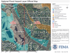
1/10/2022 (Mon), 1-2 pm: FEMA Map Basics (including Letters of Map Change) Register
-
1/12/2022 (Wed), 9:30-10:30 am: Floodplain Web-based Maps & Tools Register
-
1/19/2022 (Wed), 9:30-10:30 am: Shoreland Management Basics Register
-
1/24/2022 (Mon), 1-2 pm: Floodplain Administration 101 Register
|
-
1/31/2022 (Mon), 1-2 pm: Dealing with Zone As Register
-
2/2/2022 (Wed), 9:30-10:30: Nonconformities in Shoreland & Floodplains Register
-
2/7/2022 (Mon), 1-2 pm: Shoreland Higher Standards Register
-
2/9/2022 (Wed), 9:30-10:30: Variances - Shoreland Emphasis Register
|
-
2/14/2022 (Mon), 1-2 pm: FEMA Letters of Map Change Register
-
2/16/2022 (Wed), 9:30-10:30: Floodplain Higher Standards Register
-
2/23/2022 (Wed), 9:30-10:30: Floodplain Administration 201 (CUPs, Floodproofing, Variances) Register
|

-
2/28/2022 (Mon), 1-2 pm: Flood Insurance Basics (including Risk Rating 2.0) Register
-
3/2/2022 (Wed), 9:30-10:30: Minnesota's New State Floodplain Management Model Ordinance & Rollout Register
-
3/7/2022 (Mon), 1-2 pm: Hydroclimatic Changes Affecting Minnesota's Water-Related Resources Register
-
3/9/2022 (Wed), 9:30-10:30: Substantial Damage Determinations & Post Flood Responsibilities for Local Floodplain Managers Register
|

Do you like getting outdoors? If so, we’d love to see your pics! We’re especially looking for photos & stories from BIPOC folks who enjoy outdoor activities. #MyMNOutdoorAdventure aims to connect us to the great Minnesota outdoors—and to each other—through our shared stories. There are so many ways to get outside and enjoy nature. Show us how you do it: Share your outdoor story and photos and we’ll feature you on our website and social media channels!
|
By Dan Petrik, DNR Shoreland and River Program Manager
Determining whether a bluff exists on property in shoreland is one of the most difficult tasks faced by local zoning staff. It requires both technical knowhow and good communications skills in order to help property owners understand where bluff features exist and what shoreland standards apply.
Identifying bluffs requires an understanding of the shoreland definitions for bluff, bluff impact zone, toe of bluff and top of bluff, but it also requires knowing HOW to apply them in a systematic way to a wide variety of unique slope features to develop a consistent determination.
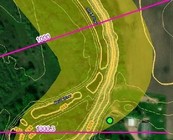
The new DNR guidance document includes technical details, and walks the reader through a specific step-by-step process, with many graphics (like the example below), to identify whether slope features meet the shoreland bluff definition.
|
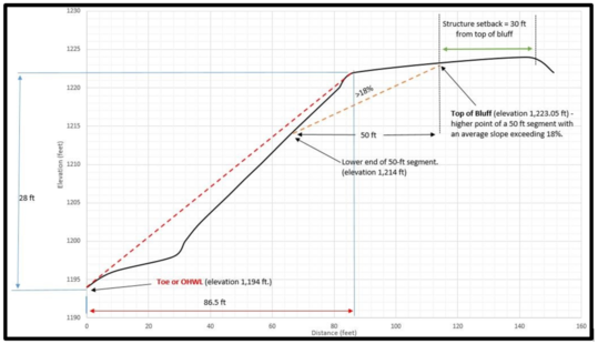 Example graphic from the new bluff calculation guidance
The guidance follows a three-step process:
-
Determining if a bluff exists. This step walks through the four criteria in the bluff definition to determine if a bluff exists. Locating the top of bluff is not needed to determine if a bluff exists.
-
Locating the top of bluff. Locating the top of bluff, along with the toe (done in first step) defines the physical extent of the bluff and is used to determine the bluff impact zone and bluff setbacks.
-
Determining whether the exemption applies. The dimensional-based exemption allows structures to be built on larger flat “terrace” areas, but only if bluff setbacks can be met. This is a very rare situation.
The guidance document also works through two bluff examples, one where the bluff rises quickly from the water where the ordinary high water level (OHWL) and the toe of bluff are the same, and another example where the toe is landward of the OWHL so they are not the same. The “Identifying Bluffs in Shoreland“ guidance can be found on the DNR’s Bluff and Slope Protection page.
We have 101 Certified Floodplain Managers (CFMs) in Minnesota as of December 2021! And Wisconsin is just behind with 100 CFMs.
We had been at 94 CFMs in Minnesota at the time of the November 2021 joint Minnesota/Wisconsin conference (co-hosted by Minnesota Association of Floodplain Managers & Wisconsin Association for Floodplain, Stormwater, & Coastal Management). But those who took the CFM exam on the final day of the conference (and passed) pushed the cadre of Minnesota and Wisconsin CFMs to triple digits.
The CFM program requires passing an exam and then continuing education credits to maintain certification. Recognizing training/continuing education/professional development is a keystone of the program, as the floodplain management program is continually evolving and the knowledge and performance of local, state, federal and private-sector floodplain management professionals is ever changing.
Learn more about the CFM Program here on the Association of State Floodplain Managers site.
|
By Ceil Strauss, DNR, State Floodplain Manager
FEMA no longer requires the FEMA Elevation Certificate (EC) for new flood insurance policies - including in the high risk zones - issued after Oct. 1, 2021 (under the new Risk Rating 2.0, or RR 2.0). And starting on April 1, 2022, policy renewals will be rated using RR 2.0. As a result, we are hearing questions about whether FEMA ECs are being used anymore.
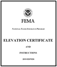
For Flood Insurance - Not required, but often helpful to get lower premiums
Under the legacy system, an EC was required to rate policies for post-FIRM structures in the Special Flood Hazard Areas, i.e., in the mapped higher risk areas, but not in the medium and lower risk Zone X areas.
Under RR 2.0, an EC is no longer required to rate a policy. HOWEVER, an EC can be used in ANY Zone if it will result in a better rate. Many agents with larger flood coverage portfolios have noted the ECs help - sometimes significantly - in a high percentage of quotes.
For Regulatory Purposes - The short answer is yes!
CRS communities - Community Rating System (CRS) standards still require the FEMA EC be used to document building elevations, so CRS communities must continue to use ECs.
Non-CRS communities (most communities) - Federal regulations (44 CFR 60.3 (b) (5) (i)) specify the community must “obtain the elevation (in relation to mean sea level) of the lowest floor (including basement) of all new and substantially improved structures.” And 44 CFR 60.3 (b) (5) (iii) specifies you must “Maintain a record of all such information with the official designated by the community.”
The FEMA EC is an encouraged alternative to document the community permit requirements have been met.
|
Who is qualified to document "as-built" elevations?
-
State elevation minimum documentation: Minnesota Rules 6120.5800, Subp. 1 specifies that the finished fill and floor elevations must be in compliance with the community's regulations based on "a certification by a registered professional engineer, land surveyor, or other qualified person designated by the local governing body."
-
Dry floodproofing: Federal regulations (44 CFR 60.3 (c) (4)) and State Rules (6120.5900, Subp. 3, D.) specify that when floodproofing of a non-residential building “a registered professional engineer or architect shall” … “certify” the floodproofing design and height of floodproofing. (Dry floodproofing of residential buildings is only allowed in communities with an official “basement exception,” and they would also have the requirement for a PE or architect to certify the design and height of floodproofing - a handful of Minnesota communities in the Red River Valley have this exception).
Documentation is required to show regulations are met
- As noted above, documentation that the fill and lowest floor elevations meet the community regulations is mandatory. The documentation should be in the same datum used on the community's FEMA maps, i.e., NAVD88 or NGVD29, not in an assumed datum.
- A FEMA elevation certificate is not required (except in CRS communities), but may be used, and is highly encouraged for flood insurance rating purposes.
- A survey by a licensed surveyor or professional engineer using another form or format may also be used.
- Community floodplain ordinances often specify that elevation documentation must be done by a licensed surveyor or PE, but some ordinances may include language that the local floodplain administrator may also accept a survey by another "qualified person." (Hint: If they cannot provide the documentation in a feet above mean sea level datum such as NAVD88, they are not qualified.)
- In cases where the building is clearly high, using LiDAR elevation data may be an option. See the article below for more details on that option.
Note: Remember Minnesota minimum requirements also require documentation that residential buildings have fill extended at least 15 feet at the elevation of the RFPE minus one foot (unless using an alternative elevation method allowed with a Conditional Use Permit or Special Use Permit), and many community regulations require documentation that the access meets minimum elevations (typically the RFPE minus two feet).
By Ceil Strauss, DNR, State Floodplain Manager
Note: Not familiar with LiDAR? Learn more at Minnesota's LiDAR data and the MNTOPO web application pages. See the October 2021 Water Talk article MnTOPO Viewer - Review of a Useful Tool.
Minnesota has had LiDAR data statewide for many years now, and it can be used for supporting documentation that minimum elevation requirements are being met in many circumstances. Two foot elevation contours - derived from the statewide LiDAR - are readily available. The contours have an accuracy of one half the contour interval, or +/- one foot.
When it’s not a close call, the two foot elevation contours can be used instead of a survey. See the following examples where the two foot contours can be used for elevation documentation rather than a site-specific survey:
- High Above Base Flood Elevation (BFE) Example:
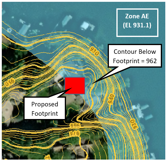
A house is proposed in a spot that is entirely above the 962' NAVD88 contour. Since the accuracy of the two foot contours is +/- one foot, we can say the site is at 961' NAVD88 based on the LiDAR.
In this example, the BFE is 931.1' NAVD88, and it's on a lake, so the Regulatory Flood Protection Elevation (RFPE) is 932.1' NAVD88 (or whatever the local ordinance requires, if higher). Even if a full basement is proposed, we know it will still be above the RFPE since the site is over 30 feet above the BFE.
This is a good example where the LiDAR can be used to document the minimum low floor elevation is being met.
NOTE: Unfortunately, this situation is common in counties with older maps or that started the process to get digital Flood Insurance Rate Maps (DFIRMs) before LiDAR was available.
2. Within Shoreland District, but Outside Regulated Floodplain Example:
|
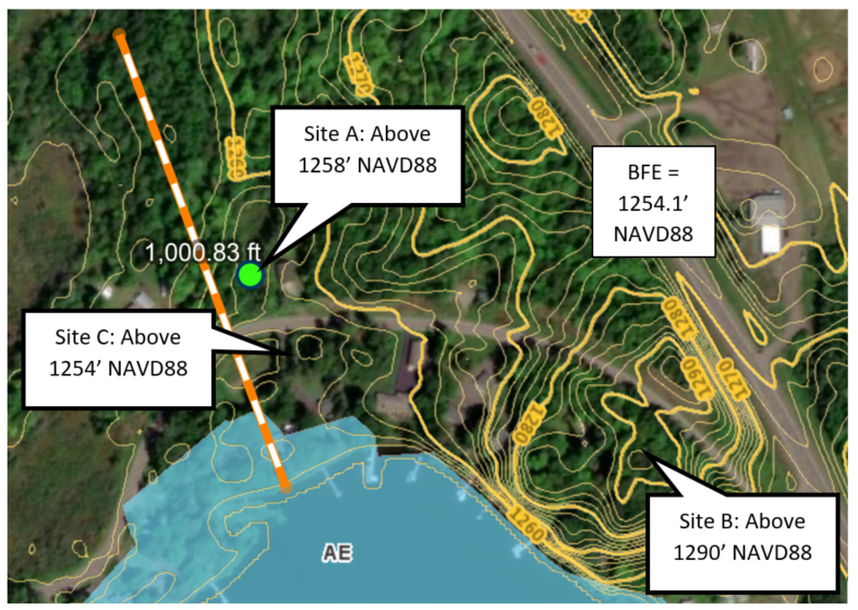 Minnesota regulations require all buildings within the shoreland district to have their lowest floor (including basements/crawls spaces) meet minimum elevations. The lowest floor must be above the RFPE if the BFE has been determined. If there is no BFE available, that lowest floor must be three feet above the Ordinary High Water Level (OHWL) or the Highest Known Water Level, whichever is higher. Since the area below the RFPE is within the regulatory floodplain, these areas should have ground elevations above the RFPE.
-
Site A - Slab on Grade Example: The ground for a proposed pole barn is above 1258' NAVD88, so the "LiDAR elevation" is 1257' NAVD88 (taking the +/- one foot of accuracy into account). The BFE is 1254.1' NAVD88 and the RFPE is 1255.1' NAVD88. If the application shows they are putting the slab at or just above the current grade, the LiDAR is adequate supporting documentation to show they are meeting the minimum elevation requirement. But if they are proposing a house (or other building) with a crawl space or basement, they could only propose to go about a foot below grade. Any deeper would require a field survey and plans that verify the lowest floor will be above the RFPE.
-
Site B - Home on High Ground Example: The ground for the proposed new home is above contour 1290' NAVD88, so LiDAR elevation of 1289' NAVD88. The RFPE is 1255.1' NAVD88, so the site is about 34 feet above the RFPE. Survey documentation is not required, but documentation of the two foot contour supporting data must be in the permit file.
-
Site C - Garage Example: The ground for a proposed garage less than 576 square feet is above 1254' NAVD88, so LiDAR elevation of 1253' NAVD88. The RFPE is 1255.1' NAVD88. The proposed garage can meet the minimum elevation one of the following ways: (1) use the LiDAR documentation, elevate the slab on fill to at least two feet above the existing ground; (2) get a field survey done and elevate the slab as needed to meet the RFPE; or (3) use the LiDAR elevation, and meet the wet floodproofing option for accessories used solely for parking and/or storage, i.e., well anchored, flood resistant materials and utilities (i.e., controls/outlets) elevated to the RFPE or higher, and properly sized & located auto opening vents.
- Note: The elevation of site C is actually below the regulated floodplain elevation, based on the accuracy of the LiDAR data, but the same steps apply.
Other reminders:
- Structures must meet required setbacks.
- If local regulations have more stringent minimum elevations, or other higher standards, those local regulations must be met.
Note: The examples used in this article were created with DNR's Lake & Flood Elevations Online (LFEO) mapper. See the July 2021 Water Talk Enhanced Lake & Flood Elevations Online (LFEO) Viewer is Live! article for user hints.
FEMA posted "Ghostbusters: Afterlife | Emergency Preparedness" public service announcement (PSA) late November 2021.
In this fun message, FEMA has a new partnership with Ghostbusters: Afterlife. They remind people that whether it’s a ghost encounter or a natural disaster, it always helps to be prepared. Make sure you and your family are ready for any emergency, from specters to wildfires, by going to ready.gov/plan or listo.gov/plan today.
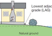
 Image from FEMA's OFIA "Basement" video released September 2021
FEMA notes this video brought to you by The Ready Campaign and the Ad Council, in partnership with Sony Pictures Entertainment.
|
The National Flood Insurance Program (NFIP) has had many short extensions since the last five-year extension that expired Sept. 30, 2017. The latest extension was set to expire Dec. 3, 2021. On Dec. 3, the President signed legislation passed by Congress that extends the NFIP’s authorization to Feb. 18, 2022.
FEMA reports that they and Congress have never failed to honor the flood insurance contracts in place with NFIP policyholders. Should the NFIP’s authorization lapse, FEMA would still have authority to ensure the payment of valid flood claims with available funds.
|
|
 |

However, FEMA would stop selling and renewing policies for millions of properties in communities across the nation. Nationwide, the National Association of Realtors estimated in 2017 that a lapse might impact approximately 40,000 home sale closings per month.
|
Important Dates to Note:
(since October 2021 Water Talk and upcoming in next couple months)
|
|
 |
Preliminary Maps
- Oct. 29, 2021: Watonwan County (revised panels)
- Dec. 17, 2021: Pennington County (revised panel)
Local Officials Meetings & Open Houses*
- Lincoln County Local Officials Meeting - Jan. 4, 2022, 2-4 pm
- Twin Cities Mississippi River HUC8 (portions of Anoka, Carver, Dakota, Hennepin, Ramsey, and Washington Counties) - Local Official Flood Risk Review Meetings:
- Coon Creek Watershed - February/March 2022
- Elm Creek Watershed - February/March 2022
- West Mississippi Watershed -February/March 2022
*All meetings and open houses expected to be virtual until further notice.
90-Day Appeal Periods
- Blue Earth County - 11/10/2021 to 2/8/2022
Letters of Final Determination (LFDs)
- Lyon County (panels with levees) - March 2022
Effective (6 months after LFD date)
- Rice County (Zumbro watershed panels) - April 6, 2022
Additional Map Update Information:
|