|
July 27, 2021
By Ceil Strauss, DNR, State Floodplain Manager
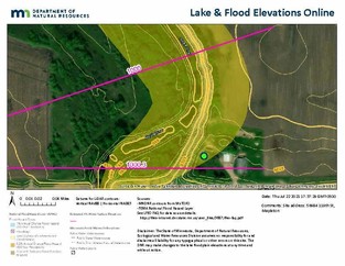
DNR’s Lake Flood Elevations Online (LFEO) became public over a year ago, providing a platform to see available flood elevations for lakes and other basins in Minnesota. (For more information about the original site and features, see the May 2020 Water Talk article Minnesota's Lake Flood Elevations Online (LFEO) viewer.)
New Enhanced Lake & Flood Elevations Online (LFEO)
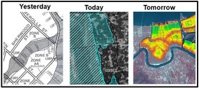
Over the past year, DNR staff have been hard at work adding several enhancements and data layers, and our new Lake & Flood Elevations Online viewer is now public!
The viewer continues to offer many background options and expanded search options (in addition to addresses) - including: lake names, DNR basin numbers and latitude/longitude.
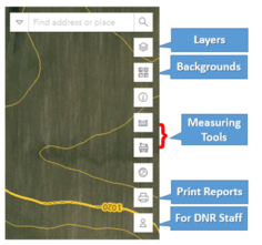
The enhancements include many additional layers, measuring & transparency tools, and printed report options.
|
New Layers
The biggest enhancement is the addition of many layers that are useful for floodplain management evaluations, and for many other purposes! These layers are all currently available from FEMA or on the Minnesota Geospatial Commons site (for sharing public spatial data), but this platform allows for a user-friendly use of these layers – and you don’t have to be a GIS expert!
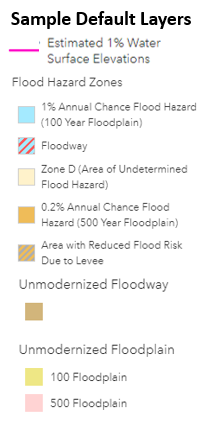
New layers in default view:
- 2-foot elevation contours (in NAVD88 datum)
- 1% annual chance water surface elevations (aka “pink lines”)
- FEMA’s Flood Hazard Layers:
- For Digital Flood Insurance Map, or DFIRM, counties
- Flood Hazard Zones; Cross-Sections & Base Flood Elevation lines (if Zone AE)
- DNR’s “unmodernized” FEMA floodplains:
- In current paper map counties where “unmodernized” floodplain layers (also known as “Q3” layers) are available
- “100-year” floodplain (Zones A, AE, A#, AO, & AH), “500-year” floodplain, and floodway
|
|
 |
Optional layers (that can be added):
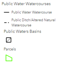
- Minnesota public water basins and public watercourses
- Parcel lines (when zoomed in closer parcel boundaries are seen, a bit closer the IDs are seen)
- FEMA layers: FIRM panels, Letter of Map Revision (LOMR) boundaries & case numbers (LOMA layer coming soon.)
|
User Hints
Select the layers icon to see more options.
-
Layers on/off: Turn layers on or off by clicking on "eye" symbol
-
Expand options: Click on the pointer, or triangle, next to the title for a grouping to expand the layers in that group (e.g., in National Flood Hazard Layer group)
-
Transparency: To change the transparency of the symbols of a grouping, click on the ... to the right, and the option to increase or decrease opacity
 Two New Print Options
1. Map of chosen area and layers:
- User can zoom to extent of choice and turn on (or off) layers of interest (if layer is seen at that scale).
- The print function will ask you to click on the site of interest (so a location dot is included). There is an option to add comments (e.g., address of subject site, or Base Flood Elevation & source, etc.)
|
 |
|
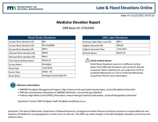
2. Basin Report: Select a basin and get printout of a table with available flood elevations for different flood frequencies (if darker blue “Published Elevations” basin), and – if available – the Ordinary High Water (OHW) elevation, and highest recorded elevation (and date). |
For more information, to provide suggestions to improve the site or if you find that any information appears to be in error, or missing, please contact DNR’s Floodplain staff.
 The summer meeting of CHAOS will be on Wednesday, July 28 from 1 – 2:30 pm. We are excited to learn about the Digital Coast and Saxon Harbor restoration project at our meeting. Please register to join us. It's not too late!
- Brandon Krumwiede and Rebecca Nicodemus from NOAA’s Office for Coastal Management will share the Digital Coast with us. Digital Coast offers training, tools and resources for coastal communities, professionals and stakeholders. We will learn more about what tools and data are available for the Great Lakes, see demonstrations of using the site, and learn about available support for communities and stakeholders.
- Saxon Harbor is the only public access point to Lake Superior in Iron County, WI. In 2016, the harbor was decimated during a storm event, with damages to the marina and campground. Now five years later, the harbor has recently celebrated it reopening. Eric Peterson, Forest Administrator for Iron County, will share about the recovery and restoration of Saxon Harbor. We will learn more about the collaborative efforts to make Saxon Harbor more resilient to future storm events.
Please register to join us: https://umn.zoom.us/meeting/register/tJAoceiqqjMvHtfw2rvJc14fCn4QuHEmdPbd
Individuals with a disability who need a reasonable accommodation to participate in this event, please contact Melanie Perello at (218) 834-1404 or melanie.perello@state.mn.us by Wednesday, July 21, or call using your preferred Telecommunications Relay Provider.
By Carmelita Nelson, DNR, Water Conservation Consultant
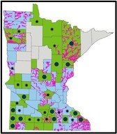
As of July 20, 72 percent of Minnesota is experiencing Severe Drought and 19 percent is now in Extreme Drought. Fire danger is high over central counties in Minnesota. To learn more, SIGN UP to receive GovDelivery drought email updates.
 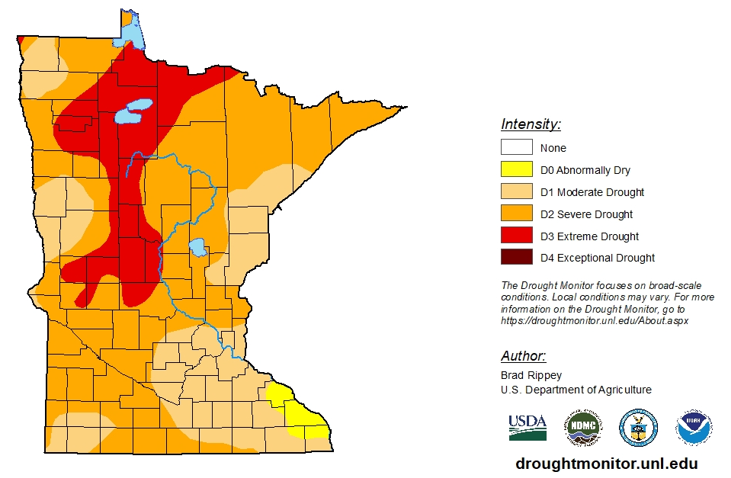 Weekly Minnesota Drought Monitor map released July 22, 2021
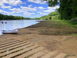
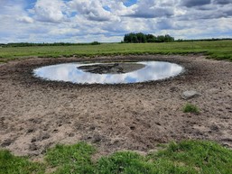
The lack of precipitation has reduced water levels in our lakes and rivers, as seen in the photo (to the right) of a St. Croix River boat ramp.
Some Surface Water Appropriation Permits Suspended
This has resulted in the suspension of water appropriation permits in watersheds with severe drought. Suspension of more surface water appropriation permits is expected unless there is a dramatic change in the current climatic trend.
Municipalities are exempt from surface water suspensions, but are required to use water efficiently through a variety of strategies they can employ like repairing leaks and enacting lawn watering restrictions for their customers. Even a return to normal precipitation for the balance of this year would do little for surface waters in many areas of the state as we enter the driest months of the year.
Groundwater Supply Concerns
Although surface water sources are the first to experience critically low levels during extended dry periods, the current demand on groundwater is beginning to stress groundwater supplies in localized areas of the state. DNR staff have received residential out-of-water complaints from eight counties in the state and are conducting well interference investigations. More than 75 percent of Minnesotans rely on groundwater for their water supply.
What can you do to conserve water?
|
Times of drought bring a reminder of the importance of water. The Minnesota Department of Natural Resources (DNR) is encouraging every individual, every business, and every organization to conserve water. Minnesotans are renowned for being environmental leaders. We ask you to significantly reduce or stop lawn irrigation on your properties, delay car and building washing, and avoid other non-essential water use like swimming pool filling. Look for and repair leaks, and seek innovative ways to conserve or reuse water. Saving water also saves energy costs and this is good for your budget and good for our natural resources.
|
You are encouraged to learn about water conservation, identify ways to reduce water use, and take action now. Everyone's help is needed to get through the current drought conditions and reduce the chances of water conflicts and surface water depletion.
As the summer heats up, please be sure to alert your local DNR hydrologist to any water supply concerns or issues. Surface and groundwater resources are shared by all Minnesotans and must be preserved for the future.
By Matt Bauman, DNR, Shoreland and Floodplain Planner
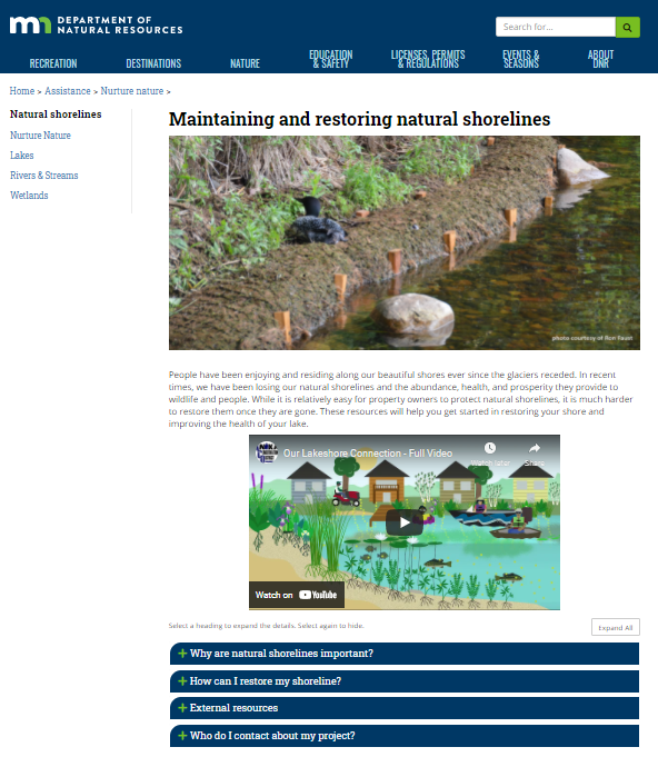
The DNR recently rolled out a new page promoting natural shorelines - Maintaining and Restoring Natural Shorelines.
This new page is designed for interested property owners and local officials, and centralizes much of the DNR’s related guidance on all things shore restoration. If you are a property owner considering shoreline restoration, or find yourself working with property owners who would benefit from some type of restoration – or even a few plantings – please feel free to share this page and encourage them to click around.
|
 |
|
Many helpful graphics and photos are included.
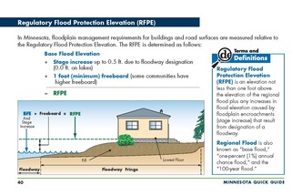
This example page explains the definition of Regulatory Flood Protection Elevation (RFPE), the minimum lowest floor requirement.
|
Important Dates to Note:
(since Spring 2021 Water Talk)
|
|
 |
Preliminary Maps
- July 2021: Itasca (revised) and Watonwan (revised panels) Counties
- September 2021: Dodge, Lincoln, Stevens (revised panels), Wabasha and Waseca Counties
Local Officials Meetings & Open Houses*
- Carlton County
- Local Official Meeting - Aug. 19, 2021
- Public Open House - Sept. 23, 2021
- Twin Cities Mississippi River HUC8 (portions of Anoka, Carver, Dakota, Hennepin, Ramsey, and Washington Counties) - Local Official Flood Risk Review Meetings:
- Coon Creek Watershed - September 2021
- Elm Creek Watershed - September 2021
- West Mississippi Watershed - September 2021
*All meetings and open houses expected to be virtual until further notice.
90-Day Appeal Periods
- Blue Earth County - 7/29 to 10/26/2021
- Lake of the Woods - 8/11 to 11/9/2021
- Lyon County (panels) - 7/8 to 10/5/2021
- Pope County - 7/20 to 10/18/2021
- Nicollet County - 7/29 to 10/26/2021
Letters of Final Determination (LFDs)
- Rice County (panels) - October 2021
Effective (6 months after LFD date)
- Cottonwood County - Sept. 24, 2021
- Yellow Medicine County - Oct. 7, 2021
Additional Map Update Information:
|