|
May 13, 2020
By Ceil Strauss, DNR, State Floodplain Manager
Some common questions
- Where do I find the official FEMA floodplain map for my area?
- My lender told me flood insurance is mandatory. How do I confirm that?
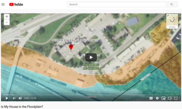
When talking about the FEMA floodplain maps, one of the first questions local officials, lenders, insurance agent, surveyors, Realtors and others are asked is whether a house or property is "in" the floodplain, either for zoning and building decisions or to determine whether flood insurance is mandatory for a loan or other purpose. The DNR created a new video that walks users through the steps of finding and downloading floodplain maps for their specific location.
How to view the video:
Topics covered in the video:
- Why floodplain maps are important and floodplain terminology.
- Find what type of FEMA floodplain map is available in your county (in Minnesota).
- Find and print FEMA Digital Flood Insurance Rate Maps (DFIRMs).
- Find and print FEMA paper Flood Insurance Rate Maps (FIRMs).
-
How to verify and document if there is not a FEMA map
- Introduction to “MNTOPO” (Minnesota interactive map with 2-foot elevation contours).
By Matt Bauman, DNR Floodplain and Shoreland Planner
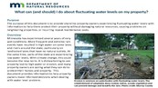
We’ve been seeing consistently high water levels throughout Minnesota over the last couple years, and property owners are becoming increasingly concerned. In addition to the damages experienced by property owners, these periods of high water levels have led to significant erosion issues.
New guidance for property owners
Property owners should work closely with their local permitting office on land altering projects, and recognize that some communities have adopted more restrictive ordinance standards. Also, many counties, watershed management organizations and cities have programs to provide technical guidance on shoreline restoration and stabilization. Local grant or cost-sharing opportunities may be available for projects that help with clean water efforts or flood damage reduction.
|
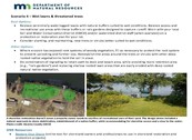
Considerations for permitting offices
Many permitting offices are wondering what more they can do to help homeowners reduce the damages caused by continued and future high water periods. The February 2020 issue of Water Talk highlighted Morrison County’s Special Protection District for Landlocked Lakes. Additionally, the Innovative Shoreland Standards webpage highlights a number of creative ordinance provisions and administrative best practices.
The Association of State Floodplain Managers (ASFPM) holds an annual conference that is the premier opportunity to learn about all aspects of floodplain management, including: latest national policy and resource updates, floodplain mapping and modeling, flood risk reduction, higher standards, and innovative projects involving floodplain natural beneficial functions. Those who have been able to attend in the past can attest to how educational the sessions are and the benefits of interacting with flood-risk professionals from around the country (and world).
If you've ever wanted to attend, but couldn't commit to the time and expense to go in-person in the past, this is the year to get a taste of what you've been missing!

Details
Dates: June 9 -11, 2020
Cost: $300 for ASFPM members; $350 for non-members
Registration: See ASFPM site for virtual conference registration.
While this year’s virtual event cannot truly replace the face-to-face interactions and networking opportunities, ASFPM is actively working to reformat the 2020 ASFPM Annual National Conference into a robust online format. The virtual conference will include three days of live plenary sessions, over 50 concurrent sessions with more than 150 presentations, a virtual exhibit hall, sponsor interaction, live Q&A, and more!
After the live conference is over, attendees will have access to the entire virtual conference platform until January 31, 2021! Imagine the benefit of being able to log back into the platform to watch sessions you might have missed or would like to watch again.
Participation in the full virtual conference will still earn you 12 Continuing Education Credits (CECs) for Certified Floodplain Managers (CFMs) upon attendance verification.
Scholarships available for Minnesota local officials to attend
|
|
The Minnesota Association of Floodplain Managers (MnAFPM) is offering scholarships to local officials (staff, elected and appointed) to attend the ASFPM virtual conference.
How to apply
|
|
 |
By James Sink, FEMA Region 5 (Chicago), Regional Flood Insurance Liasion
Elevated lake levels
Elevated lake levels and wave hazards continue to threaten communities along the Great Lakes. Understanding these risks can help residents make informed decisions about how to ensure their families, homes, businesses, and communities are safer and stronger.
The risk of flooding is one possibility that coastal property owners should be prepared for. Take steps to be ready for this risk by learning local evacuation routes, gathering supplies needed in an emergency and verifying your property is properly insured.
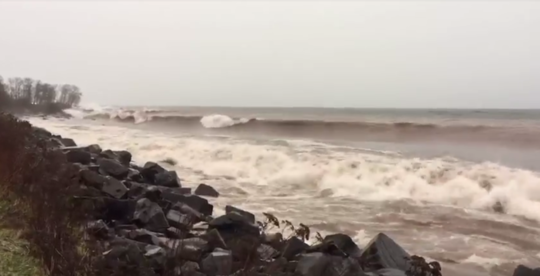 During a storm on Brighton Beach, Lake Superior. (Photo source: DNR)
Learn about flood insurance
Flood insurance is an important part of financially protecting a home or business from the expensive damage floods can cause. FEMA’s National Flood Insurance Program or NFIP makes flood insurance available to communities that agree to adopt and enforce floodplain management regulations. This coverage is only available for properties in these participating communities, but most communities across the country participate.
While it’s always a good idea to talk to your insurance agent about the risks you face and the types of insurance coverage you may need, consider a few facts about FEMA’s Standard Flood Insurance Policy (SFIP)—especially as it could relate to structures along the Great Lakes coastline—to make the most informed preparedness decisions:
-
In general, it takes 30 days from the day you purchase flood insurance for the policy to go into effect. When purchasing a policy, ask your agent when coverage will start. A newly purchased flood policy does not cover damage that occurred before the policy becomes effective. A newly purchased flood policy also does not insure for damage that occurs after the policy becomes effective if the flood causing the damage was in progress at the time the policy became effective.
-
NFIP flood insurance is a single peril insurance product. This means that the Standard Flood Insurance Policy (SFIP) covers only direct physical loss by or from flooding as defined in the policy: a general and temporary condition of partial or complete inundation of two or more acres of normally dry land or of two or more properties (at least one of which is your property).
-
Direct physical damage is not covered by the SFIP if it is caused directly or indirectly by: the pressure or weight of ice; freezing or thawing; and rain, snow, sleet, hail, or water spray. This means ice heaves and similar physical damage from ice is not covered.
-
Damage caused by gradual erosion or earth movement—even when flooding directly causes the movement—is not covered by the SFIP. In addition, a SFIP is designed to provide coverage to buildings and their contents, not loss of land.
If in doubt, policyholders should always file a claim and work with their insurance company to address specific loss questions. Each claim is adjusted individually. If a policyholder receives a denial letter to the claim filed, they always have the right to file an appeal.
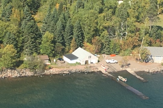 High water on Lake Superior. Portions of docks are underwater. (Photo source: DNR)
 |
|
For more information about NFIP flood insurance, you can contact your local insurance agent, call the NFIP Help Center at 800-427-4661 or visit www.FloodSmart.gov. |
We are the "Land of 10,000 (plus) Lakes," so why isn't there an easier way to find up to date flood elevations for those lakes? Now there is!
Lake Flood Elevations Online (LFEO) - an interactive map application - is now available!
Use the application to view detailed flood elevations for:
- Lakes and basins with detailed data in the most recent FEMA Flood Insurance Study (FIS) for the community.
- Lakes and basins with flood elevation data from other sources when the DNR has determined the data meet minimum quality standards.
If no flood elevation information is shown in this viewer, it is possible that DNR has study information (e.g. from local studies or map updates that are in progress) that can be used, depending on the situation. Check with DNR Area Hydrologists or DNR Floodplain Program staff. (Communities can work with DNR to identify basins with better quality supporting data that should be on this public site.)
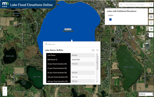 Buffalo Lake example: See search bar and other icons in upper right.
Hints for use
- In the "find address or place" box in the upper right, search by address, city, DNR lake ID number, lake name, etc.
- If the basin is a darker blue color, there is public flood elevation data.
- The "i" (information) icon opens a screen with more information and a link to an FAQs document at the bottom.
- There are many background options.
- Select the basin to see a call out box like that in the Buffalo Lake example above. The icon in the upper right (to the left of the x for closing) of the box can be selected to "dock" the box to the right and allow continued panning, zooming, etc. (The Mille Lacs example below shows that feature being used.)
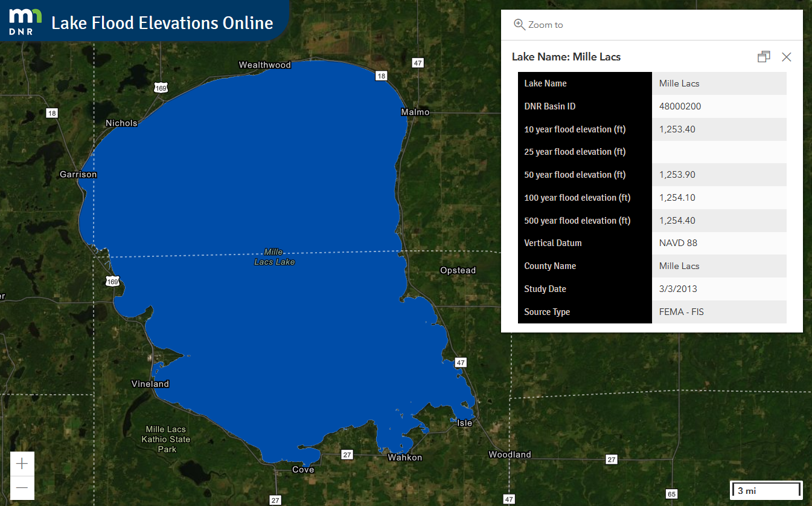 Mille Lacs Lake Example: Several flood elevations for different flood frequencies and other information can be seen in the box next to the lake.
Available data include:
- MNDNR basin name and number
- Study date and source
- Vertical Datum
- Flood elevations, if available, for:
- 10-year (10% annual chance)
- 25-year (4% annual chance)
- 50-year (2% annual chance)
- 100-year (1% annual chance)
- 500-year (0.2% annual chance)
A few more details regarding ongoing updates:
- If you find that any information appears to be in error, or missing, please contact DNR’s Floodplain staff.
- As new FEMA Flood Insurance Studies become effective, the elevations for the basins in those studies will be updated. Only the most recent study data is shown in the public application.
- Note: The study dates shown in the application are currently one day earlier than the dates in the supporting database. DNR's technical support team is aware of the issue and plans to address the problem ASAP.
Flood management protects people and property. The Association of State Floodplain Manager's (ASFPM) three-part guide breaks down the key information you need to fulfill your responsibility as an elected official.
Wise flood management provides the means to address your flood problems before, during, and after an event, as well as create sustainable development for future generations.
How to get a copy:
The ASFPM Flood Science Center Understanding and Managing Flood Risk: A Guide for Elected Officials has links to all three volumes, and many other related resources.
The guide’s three parts include:
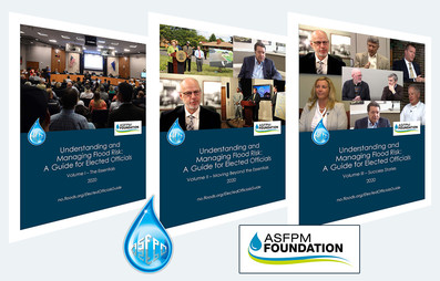
- Volume I: The Essentials
- Volume II: Moving Beyond the Essentials
- Volume III: Success Stories
|
Editor's note: This article is adapted from the ASFPM Flood Science Center page for the Elected Officials Guide.
FEMA Technical Bulletins
The National Flood Insurance Program (NFIP) Technical Bulletins provide guidance for complying with the NFIP’s building performance requirements and are designed to help state and local officials interpret the NFIP Regulations. They are also a useful resource and reference for homeowners, insurance agents, building professionals and designers.
FEMA is updating the NFIP Technical Bulletins to improve their usability, credibility, and content while presenting them in a streamlined format. Technical Bulletins 1 & 5 were last updated in 2008. These updated editions incorporate the latest relevant codes and standards and state-of-the-art guidance and best practices. They were developed with significant stakeholder input to help local officials meet or exceed relevant NFIP requirements.
Technical Bulletin 1 Update
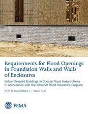
Technical Bulletin 1, Requirements for Flood Openings in Foundation Walls and Walls of Enclosures (TB 1) explains the NFIP requirements for flood openings in exterior walls and walls of enclosures below elevated buildings. Flood openings equalize flood forces by allowing the entry and exit of floodwaters. This Technical Bulletin describes two options for satisfying the requirements, referred to as engineered openings and non-engineered openings. In addition to illustrating enclosures that require openings and those that do not, TB 1 covers the requirements and guidance for installation of openings. Updates include:
- New tables comparing National Flood Insurance Program opening requirements with related building code requirements;
- Guidance on unusual configurations such as sloping sites, multiple enclosed areas, large enclosed areas, and sites with shallow flooding;
- New guidance on above-grade enclosed areas and two-level enclosures;
- Expanded discussion on completing the FEMA Elevation Certificate (EC) and documentation for certification of engineered openings.
Technical Bulletin 5 Update
|
Technical Bulletin 5, Free-of-Obstruction Requirements (TB 5) provides guidance on the National Flood Insurance Program free-of-obstruction requirement in Coastal High Hazard Areas (Zone V), as well as general construction methods that minimize flood damage potential in Zone V. Minnesota does not currently have Zone V, but is expected to have Zone V along Lake Superior in the future.
Resources:
Editor's note: This article excerpted from FEMA and a March 24, 2020 ASFPM releases.
Expanded update is here!
The 2020 update of the Floodplain Management in Minnesota Quick Guide has arrived. If you liked the 2018 version, you'll like this this version even better!
The Quick Guide is filled with useful graphics and targeted at local officials and other professionals involved in floodplain management, as well as landowners.
|
How to get a copy:
Additions include:
- More details on FEMA Letters of Map Amendment (LOMA) options.
- Information on newer resource applications: Minnesota FEMA Hydraulic Model download site and Minnesota Lake Flood Elevations Online (LFEO).
|
|
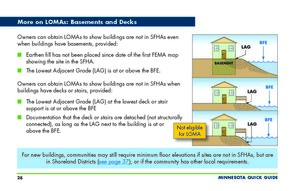 |
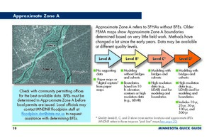
- More details on Zone A quality levels and BFE sources.
- Guidance on requirements that limit water level increases when floodway is not delineated.
- Improved graphics on many pages.
|
|
 |
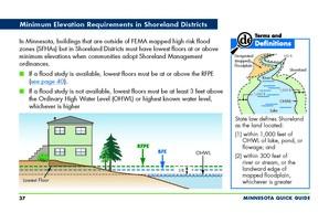
- Minnesota minimum lowest floor elevation requirements required in Shoreland districts.
- Minnesota requirement to follow floodplain regulations beyond the mapped area if natural ground is below one-percent annual chance flood elevation based on actual ground elevations.
|
|
 |
See Water 2019 Water Talk article on the original 2018 Quick Guide for a summary of other content in the original Quick Guide that is also included in the 2020 Quick Guide update.
Note: FEMA has currently put new Letters of Final Determinations and beginning new 90-day appeal periods on hold due to COVID-19.
Actual, scheduled, and projected dates since February Water Talk:
Preliminary Maps
- Nicollet County - Feb. 28, 2020
- Pennington County - March 31, 2020
- Watonwan County - April 24, 2020
- Olmsted County (panels) - May 2020 (tentative)
- Lake of the Woods County - May 2020 (tentative)
- Pope County - May 2020 (tentative)
- Stevens County - May 2020 (tentative)
- Polk County (revised) - May 2020 (tentative)
- Koochiching County - June (tentative)
- 2020 (anticipated): Blue Earth (panels), Carlton, Chippewa, Dodge, Itasca , Le Sueur, Morrison, Pipestone (~Dec. 2020), Rock (~Dec. 2020), St. Louis (~ Dec. 2020), Wabasha, Waseca and Winona Counties
Local Officials Meetings & Open Houses
- Goodhue County (panels) - March 11, 2020
- Nicollet County - April 9, 2020 (virtual local official meeting)
- *Rice County (panels) - June 2020 (tentative)
- *Pennington County - June 2020 (tentative)
- *Olmsted County (panels) - Q3 2020 (tentative)
- *Watonwan County - Q3 2020 (tentative)
* Local official meetings are anticipated to be virtual.
90-Day Appeal Periods
- Red Lake County - Ended April 14, 2020
Letters of Final Determination (LFDs)
- Marshall County - was scheduled for April 1, 2020, but delayed to TBD
- Wright County - was scheduled for May 6, 2020, but delayed to TBD
- Scott County - was anticipated June 2020, but now TBD
- Red Lake County - was anticipated June 2020, but now TBD
Effective (6 months after LFD date)
None currently
Additional Map Update Information:
|