City of Austin
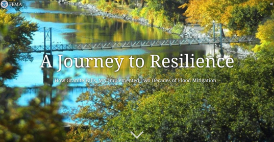
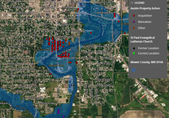
In 2018 we had the twenty-five year anniversary of the 1993 floods that hit much of the Midwest. The FEMA Region 5 story “The Great Floods of 1993 – 25 Mitigated Year Later” features Austin, MN (in addition to Darlington, WI and Grafton, IL). See an interactive map (example to right) showing the property acquisitions and relocations, “Before & After Swipe Maps,” explanation of flooding history, and discussion of the assortment of flood risk reduction tools used by the city.
|
Cities of East Grand Forks, Moorhead & Breckenridge
In 2017, the twenty year anniversary prompted FEMA to publish the Red River Flood 1997 and FEMA Region 5 Mitigation Efforts story book. This story features acquisitions after the 1997 flood in three Minnesota communities: East Grand Forks (about 400 buyouts), Moorhead (about 30 buyouts associated with 1997 flood and many more in later projects) and Breckenridge (about 20 buyouts). The story covers: Cause of the Flood, Disaster Declaration, Flood Extent & FEMA Region V Mitigation, and “Before and After Swipe Maps” for East Grand Forks, Moorhead & Breckenridge.
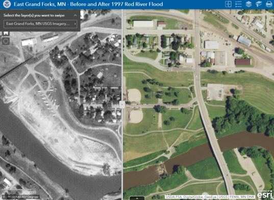 "Before and After Swipe Map" example using map for City of East Grand Forks in the story book link included above
By Kevin Zytkovicz, MNDNR, River Channel Specialist
A network of water resource professionals sharing watercourse field based information.
Why would you use it?
- To understand what ‘we’ collectively know about Minnesota’s many watercourses, through time.
- To share expensive watercourse field information with other water resource professionals.
- To work together, with other water resource professionals, to improve our water management.
- To back up those file cabinets of old paper files.
Minnesota’s water resources have been “managed” for over 150 years. Although millions of public dollars have been spent collecting field information on watercourse conditions, no single resource exists to obtain and share this information. As the Minnesota Channel Morphology Dataset becomes a reality, that will change!
For additional information or if you have data to contribute please visit:
Minnesota’s Channel Morphology Dataset web site
|
 |
|
The Minnesota Association of Floodplain Managers annual conference will be November 13-15, 2019 in Marshall, Minnesota. Additional information available from the Minnesota Association of Floodplain Managers .
- November 13, 2019: workshop and tour
- November 14, 2019: conference
- November 15, 2019: CFM exam offered
|
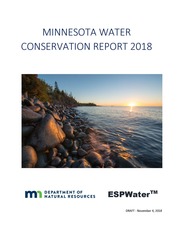
The Minnesota Department of Natural Resources has compiled the first comprehensive report on water conservation by Minnesota cities and other water suppliers. The report shows that in total, Minnesota cities met state measures for conservation and reporting. City councils often view water conservation as a loss of revenue, however, long-term conservation usually makes economic sense because it reduces treatment costs and defers the need for system expansion.
“Although we have abundant water resources in Minnesota, the water resources cities rely on are not limitless, and we know from other states and countries, they can be depleted,” said Carmelita Nelson, DNR water conservation consultant. “About 75 percent of Minnesota drinking water comes from groundwater. In some areas there is limited groundwater to begin with, and in other areas natural replenishment cannot keep up with the rate of use.” |
|
 |
The three goals of the report are to determine the impact of water conservation, encourage best practices and analyze trends. The report does not to compare cities to each other, because the amount of treatment needed varies and no two systems are identical. Rather, the report shows what has been particularly effective and encourages water conservation and efficiency. Utilities can learn from each other and be better prepared for water emergencies.
“Even where cities use surface water instead of groundwater, we still want to be careful to protect water ecosystems,” Nelson said. “Additionally, the water/energy nexus recognizes that it takes a considerable amount of energy to treat and deliver the water we use. At the same time, most energy sources use a great deal of water. By conserving water, we are also conserving energy and reducing our carbon footprint.”
The report is the first comprehensive effort to monitor water supplier conservation efforts from source to consumption, in order to determine the impact of conservation efforts in the state.
Some of the Water Conservation Report findings:
|
- 94% of the utilities submitted their water conservation report on time.
- In total, Minnesota water suppliers have a water loss of 8.8 percent, meeting the DNR conservation goal of 10 percent. Reducing water loss from leaky pipes and other infrastructure inefficiencies is the most effective way to conserve water.
- The statewide value for residential consumption is 52 gallons per capita per day, meeting the DNR goal of 75 gallons per capita per day.
- Peak daily use is 2.36, meeting the DNR goal of 2.6. This number is a ratio of maximum flow (typically in summer) to average daily flow (measured in winter).
- 190 utilities (55%) reported customer incentive programs (rebates, etc.). A Total of 8,773 customer projects resulted in over 70 million gallons of water saved.
- Utilities reported 13 water reuse projects that resulted in 75 million gallons of drinking water saved in 2017. This is the only place where water reuse is reported.
- 211 utilities reported direct conservation projects before the customer meter. This includes leak detection and repair, meter and hydrant repair and replacement. We know this number is low, some cities reported doing work but did not quantify their savings.
- 74% reported having ordinances that promote conservation; 77% reported Education & Outreach activities; 58% reported Collaboration Efforts.
Part of the reason for tracking water conservation is to determine if the state is complying with the Demand Reduction Law passed by the Minnesota Legislature in 2015. Water conservation practices can effectively reduce the demand placed upon groundwater and surface water sources as well as municipal water supply systems.
|
For more information about the water conservation report, see the MNDNR Water Conservation Reporting System web site. Once the report itself is finalized, it will be available on this site.
Contact: Carmelita Nelson, DNR water conservation consultant, 651-259-5034
By Pete Boulay, MNDNR, State Climatology Office & Ceil Strauss, MNDNR, State Floodplain Manager
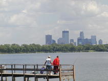
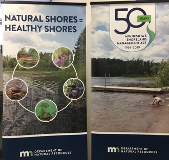
New lake names in Minnesota don't happen often, but do occur. A recent inquiry about the newly renamed Lake Cuyuna in Crow Wing County, and the recent highly publicized renaming of Lake Calhoun to Bde Maka Ska (photo to right), prompted sharing a review of the official process.
County Level
|
The official process begins at the local level.
- A petitioner acquires at least 15 signatures from registered voters in the county the feature is named. Ideally, the names on the petition should include the people most affected by the proposed name change.
- A public hearing date is set. There must be at least three consecutive notices of the hearing in the local paper and notice to the MNDNR Commissioner. MNDNR staff prepare a response offering information and perhaps guidance.
- On the day of the hearing residents of the county may provide input, and a representative of the MNDNR will often be available to answer questions. If the county board votes to approve the new name, supporting documents are submitted to MNDNR.
State Level
- MNDNR staff prepare background information and a "State of Minnesota Department of Natural Resources Approval of Names of Geographic Features" form. Basic restrictions such as no naming for a living person are considered.
- If the MNDNR Commissioner approves the geographic name change, the form is signed and the documents are sent to the county for recording.
- The recorded documents and the federal "Domestic Geographic Name Report" form, along with letters of support and opposition are submitted to the US Board of Geographic Names.
|
Final Approval
The US Board of Geographic Names reviews the packet submitted by the state, and if they agree with the name change it is approved and becomes official.
For more information, see Minnesota Statutes 83A and MNDNR web pages:

The 2018 Floodplain Management in Minnesota Quick Guide has been completed. This Quick Guide is heavy on useful graphics and targeted at local officials and other professionals involved in floodplain management, as well as landowners.
A 2019 update with additional content on available A Zone supporting data, map appeal options, and more is in progress.
|
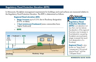
Content
- Basic floodplain management concepts and terminology
- Floodplain mapping documents and interpretation basics
- Minnesota minimum requirements for development in mapped floodplain areas
|

How to get a copy:
- When the 2019 MN Quick Guide is done it will be made available on the MNDNR Floodplain Program web site and a limited supply of copies will be printed.
|

The National Flood Insurance Program (NFIP) was originally set to expire September 30, 2017. There have been short extensions to December 8, 2017, December 22, 2017, January 19, 2018, July 31, 2018, November 30, 2018 and December 21, 2018. The most recent extension was signed on December 21, 2018 and expires on May 31, 2019.
See links to the latest updates and more information about NFIP reform and other topics of interest to floodplain managers at the Association of State Floodplain Managers (ASFPM) site.
|
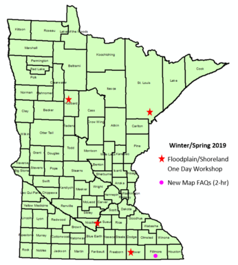
The following meetings related to mapping updates are scheduled:
- Waseca County Map Modernization Kick-off – February 13, 2019
- Breckenridge Physical Map Revision Local Official Meeting & Open House - February 20, 2019
- Pope County Flood Risk Review Meeting – Spring 2019 (date TBD)
- Stevens County Flood Risk Review Meeting – Spring 2019 (date TBD)
Kick off (for County level) and Discovery (for Watershed level) meetings are an opportunity for local officials to hear about the scope & timing of FEMA map data updates, share available data and give input on areas of flooding concerns.
Flood Risk Review meetings are an opportunity for local officials to review the work maps showing updated modeling of the 1% annual chance flood elevations and the area of the floodplain.
Contact Suzanne Jiwani for more details.
Actual, scheduled and projected dates since Summer 2018 Water Talk:
Preliminary Maps
- Wright County (revised panels) – July 31, 2018
- Blue Earth County (revised levee area panels) – September 12, 2018
- Nicollet County (revised) – September 12, 2018
- Yellow Medicine (revised panel) - January 11, 2019
- 2019 first half (anticipated): Pennington, Polk (revised), Red Lake and Winona
- 2019 second half (anticipated, but some may be pushed to 2020): Carlton, Cottonwood, Dodge, Itasca, Koochiching, Lake of the Woods, LeSueur, Morrison, Pope, Stevens, Wabasha and Watonwan
90-Day Appeal Period*
- Scott County - start Q1 2019
- Wright County - start Q1 2019
- Nicollet County - 2019
- Yellow Medicine County - 2019
Letter of Final Determination (LFD)*
- Fillmore County – Q1 2019 (anticipated)
- Marshall County - 2019
- Scott County - 2019
- Wright County - 2019
- Polk County - 2019
Effective (6 months after LFD date)
- Houston County - December 7, 2018
- Carver County - December 21, 2018
- Fillmore County - Q3 2019 (anticipated)
*Note: Some 90-day appeal periods and Letters of Final Determination were delayed due to the federal government shut-down (since notices must run in the Federal Register).
See latest timetable for past and future map updates and more about FEMA map updates in Minnesota.
|