|
July 31, 2020
By Ceil Strauss, DNR, State Floodplain Manager
New Video on Caring for our Shorelines
“Our Lakeshore Connection” is a new video by the Anoka Conservation District that was posted in June 2020. The video is an excellent resource for the general public, especially those living on or near lakes. The video highlights the basics on what impacts water quality, and healthy habitats, with the help of fun animation. Landowners also get some pointers on what they can do to improve water quality and help our living shorelines.
 Anoka County SWCD new video "Our Lakeshore Connection"
How to view the video:
While at the Anoka County SWCD site, you can also:
- Virtually tour Anoka Conservation District projects
- Watch the “Our Groundwater Connection” video
- Find educational resources on native and pollinator friendly plantings
- Learn about better lawn care and ways you can reduce nutrients and sediment entering lakes
By Matt Bauman, DNR Floodplain and Shoreland Planner
Need for Guidance Evaluating Impacts of Grading, Excavation, and Filling
Minnesota’s Shoreland Rules, Part 6120.3300, Subp. 4(B) requires that local officials assess impacts to land alteration projects and require conditions of permit approval to mitigate identified impacts.
Zoning administrators are often apprehensive about applying conditions to an administrative permit since they don’t feel they have clear zoning standards or publicly developed guidelines. In contrast, most officials find greater community support when conditions are applied through a public conditional use permit (CUP) process.
Land Alteration Plan

Le Sueur County’s Land Alteration Plan approach involves approval, like a typical administrative permit, but incorporates a more collaborative process providing some of the benefits of more public processes.
The county has very sandy, erosion-prone soils. County officials are aware of the environmental impacts associated with development on these soils, and have looked for ways to reduce impacts while minimizing time and costs to property owners.
|
Land Alteration Plan Application
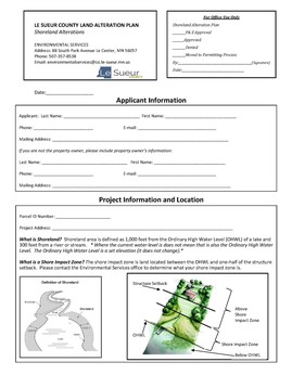
- The property owner completes and submits the plan application, which is designed to provide enough information to understand site issues and design solutions.
- The county does not charge a fee for the Land Alteration Plan application.
- Using the plan, the county works with the landowner to ensure that reasonable and responsible protections are used to slow runoff, reduce erosion, establish/ maintain/replace vegetation, or reduce impacts of impervious surfaces.
- The extent of protections or mitigating conditions is largely at the discretion of county staff, with priority protective measures clearly established by the Planning Commission.
For simple projects, the plan functions very similar to a permit; it meets the FEMA requirement that communities issue a “permit” for any development in the floodplain.
|
A Land Alterations Plan is required for the following activities in the Shoreland District:
- Riprap, beach sand blankets, rain garden projects that do not exceed grading, excavating, and filling standards (and require CUP).
- Installation of impervious surfaces greater than 32 square feet for lots less than one acre, or greater than 100 square feet for lots 1 to 1.99 acres.
- Movement of 5 to 10 cubic yards of material in shore impact zone (SIZ) or bluff impact zone (BIZ).
- Movement of 25 to 50 cubic yards of material on a lot.
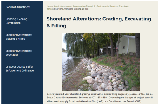 Le Sueur County site has links to the Grading, Excavating, and Filling standards and the Land Alteration Plan forms.
Property owners should work closely with their local permitting office on land altering projects, and recognize that some communities have adopted more restrictive ordinance standards. Also, many counties, watershed management organizations and cities have programs to provide technical guidance on shoreline restoration and stabilization. Local grant or cost-sharing opportunities may be available for projects that help with clean water efforts or flood damage reduction.
CUPs for Larger Projects
A larger scale project would trigger the CUP process, requiring the plan and as-builts to be completed by a professional engineer or surveyor. Applicable standards are summarized below, and are further detailed in Section 13, Subd. 5 and Section 18, Subd. 3(C) of the County ordinance.
A CUP is required for the following activities in the Shoreland District:
- Riprap, beach sand blankets, and rain garden projects that exceed grading, excavating, and filling standards.
- All retaining walls in SIZ.
- Retaining walls outside of the SIZ greater than 3 feet in height or twenty-five feet in length.
- Movement of more than 10 cubic yards in the SIZ or BIZ.
- Any grading, excavating or filling in a bluff.
- Movement of more than 50 cubic yards of material on a lot.
In addition to the requirement for a plan, the county has implemented a number of standards related to land alterations that go above and beyond that which is required by state shoreland management rules. Notably, riprap projects are only allowed to stop or restore an existing erosion hazard. Additionally, standards for vegetation removal and replacement have been clearly quantified.
More information on this higher standard and others can be found on the DNR’s Innovative Shoreland Standards Showcase page.
By Ceil Strauss, DNR, State Floodplain Manager
Torrential rains fell for a period of 6-12 hours across a large swath of southern Minnesota from the evening of Saturday July 25th into the morning of Sunday July 26th. More details about the storm can be found in Minnesota State Climatology Office’s article Southern Minnesota Mega-Rain, July 25-26, 2020.
Mega-Rain
This storm produced six inches of rain or more over an area of roughly 1000 square miles, making this event the first "mega-rain" since 2016. Portions of Blue Earth, Brown, Le Sueur, Nicollet, Redwood, Renville, Sibley and Waseca Counties had over six inches of rain, and large portions of Renville and Sibley Counties had over eight inches of rain! The highest confirmed rainfall total was 11.5 inches near Winthrop.
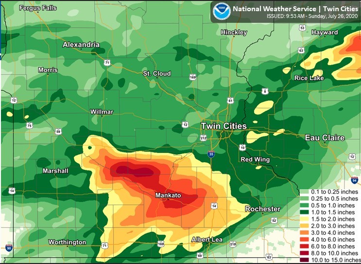 Source: National Weather Service (NWS), Twin Cities
But Not Mega Damage
The good news is that, in spite of the large scale torrential rain, there were no reports of significant structural damage. In fact, the only reported damage to structures was basement flooding. As of July 30th there were no flood insurance claims in the mega-rain counties, and there were no reports of structure damage (other than isolated reports of basement flooding) to county zoning administrators or emergency managers.
Good past floodplain management for construction of homes and businesses, and public infrastructure, helped prevent the more serious damage that is common for a storm of this magnitude in many parts of the country. Reduced damage also prevented the financial and emotional costs associated with repairing flood damages, and avoided disruption to families and commerce.
The fact that river levels were relatively low going into the event, and soil moisture was as dry as we've seen for a couple of years, also contributed to the lack of impacts.
The biggest reported impacts were:
- Many closed roads, including major roads: Highway 93 south of Henderson, Highway 19 between Winthrop and Gaylord, and Highway 22 between Mankato and St. Peter.
- Landslides in the Mankato and Blue Earth County, with at least one leaving a structure within about ten feet of the new bluff line.
- Debris and sediment left in parks and public open space areas that will be costly for local officials to clean up, and a disruption to those wishing to use the space.
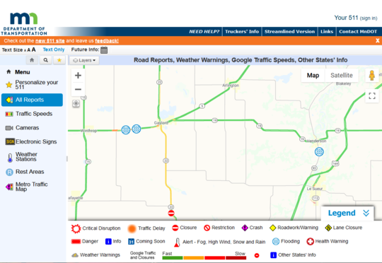 July 27, 2020 MNDOT 511 map showed "Flooding" circles at roads closed due to flooding.
Editor's note: Excerpts from DNR's State Climatology Office reports were included in this article.

The Association of State Floodplain Managers (ASFPM) has promoted the "No Adverse Impacts" (NAI) approach to floodplain management for many years. NAI tools and resources are available, including a series of "How-to-Guides" focused on helping local officials to reduce flood damage potential.
While Minnesota's proactive regulatory and mitigation efforts have helped to minimize and reduce flood damage potential, there is still much work to be done to protect our roads and other public infrastructure from flood damage. The NAI approach to infrastructure in this How-to Guide (last updated in 2016) presents concepts to consider, along with tools, case studies and additional resources.
|

Infrastructure How-to Guide Includes:
- NAI approach, in general, and terminology
- NAI approach to floodplain management and infrastructure
- NAI tools for infrastructure
- Case Studies
- Resources
|
Links to All NAI How-to Guides:
How to get a copy or see other NAI resources:
- Use the direct links above to see the How-to Guide for Infrastructure and many other topics.
- Go to the ASFPM No Adverse Impact page to see links to all the How-to Guides, an NAI Toolkit, discussions of legal issues and other related resources.
This "Floodplain Manager's Notebook" column, written by Rebecca Quinn, and appearing in ASFPM's July 2020 issue of "The Insider," is reprinted with permission from ASFPM.
Editor's note: Some local zoning administrators have noted big increases in pool permit applications over the last few months, due to more families spending time at home, so we thought this column would be of interest to many local officials.
Where I live, the sultry humid days of mid-summer are just around the corner. For many, that means it’s time to jump in the pool! Whether you go to a public pool, a club pool, or one in your backyard, splashing away a hot day probably doesn’t bring to mind floodplain management.
But you know me, I see this stuff everywhere. So let’s talk about swimming pools in flood hazard areas. First, yes, pools are development and, as we know, communities that participate in the National Flood Insurance Program must regulate development in special flood hazard areas (SFHAs). How many times has someone said “but pools aren’t insured by the NFIP,” implying there is a connection between what is and isn’t insured and what we regulate. Nope, that nexus does not exist.
We all know the requirements when someone proposes to locate a house or other building in an SFHA – the defining feature is elevation of the building’s lowest floor to or above the base flood elevation. There are lots of other requirements, but mostly we talk about how high and what type of foundation.
Now, lay that aside and tell me, what comes to mind when you think about applying floodplain management requirements to structures that I sometimes call “non-building development”? Dictionaries and the International Codes define “structure” as something that is constructed. A building is a structure, but not all structures are buildings. I wrote about this in the November 2018 Notebook column, using solar panels and domes for road salt as examples, and I highlighted outdoor sculptures in the November 2019 column.
|
Now, let’s talk about pools in SFHAs, and let’s consider the pools themselves, equipment serving pools (controls, appliances, heaters, tanks, etc.), structures that may enclose pools, and for good measure, features that makes a pool an “infinity” pool. Please note – complete guidance for pools would take more pages than I can include in this column.
Swimming Pools
As with any SFHA development, requirements vary with flood zone. Consider these factors:
- In Zone A, AE, A1-30, and other zones that start with “A,” but not in floodways: pretty much like any development in floodway fringe areas, there are few considerations. Development should be stable under flood conditions.
- In floodways: pools that are above ground and those that involve fill are encroachments, and the requirement to assess the impacts apply.
Equipment Serving Swimming Pools (controls, appliances, heaters, tanks, etc.)
To satisfy the general requirement that development must be "reasonably safe from flooding" and "minimize flood damage," communities must not simply allow pool equipment installations at-grade. And remember, just because damage to equipment isn’t covered by NFIP insurance policies does not mean installations aren’t regulated.
Equipment serving pools, including controls, heaters, tanks, and other appliances, should be elevated to the required building elevation where practical. But there is a matter of safety and practicality to consider – and here’s where my opinion comes in, because some equipment won’t operate safely if fully elevated, especially in areas where the depth of water is more than a few feet (BFE minus elevation of the ground). In those cases, I think communities can require elevation to the extent practical, even if lower than the BFE, while also ensuring equipment will be anchored to resist flood forces.
Another alternative is to put equipment in an equipment building and dry floodproof the building, even when the pool is a private pool at a home. Also, power to the equipment should be supplied by branch circuits that have ground-fault circuit interrupter (GFCI) protection. Check out guidance in FEMA P-348, Protecting Building Utility Systems from Flood Damage (2017),, Sec. 4.3.4 Mitigation for Pools and Spas. Your state may have different requirements. Always check with your NFIP State Coordinator when you have questions.
Pool Enclosures
Here I’m not talking about pools that are inside non-residential buildings, say a commercial gym or athletic club. Those buildings can be dry floodproofed if in Zones A/AE. Pool enclosures may be made of lattice, insect screening, or aluminum or concrete open screening that allows the free passage of floodwater. The recently published FEMA Policy for non-elevated, wet floodproofed accessory structures used for parking or storage is not applicable to structures enclosing pools because pools are for recreational use. The same logic applies to pools located under elevated buildings. The pools must not be enclosed by walls, including breakaway walls or glass, because the use of enclosures is limited to parking, storage, and building access.
Editor's notes:
- Portions of the original column related to coastal zones were omitted since not applicable in Minnesota.
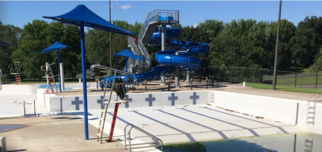
- A temporary pool like that shown in the photo below does not require a floodplain permit!
 Example of a temporary pool that does not require a floodplain management permit

Anyone visiting the FEMA.gov website over the last couple days will notice FEMA just unveiled a new redesigned site.
Unfortunately, those using their "favorites" or current links from the DNR floodplain management site (and many other sites) will see the "404 Page Not Found" error message.
DNR floodplain staff will update the links on our website as soon as possible.
|
FEMA recently released the National Flood Insurance Program, Flood Mitigation Measures for Multi-Family Buildings, P-2037. This publication provides guidance for building owners, designers, investors, builders/contractors, institutional partners, housing agencies and residents, and property and facility managers on flood risk evaluation and mitigation of large multi-family buildings located within floodplains, particularly in urban areas. The publication is also useful for local officials responsible for enforcing floodplain management regulations or building codes.
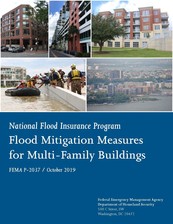
The focus of the publication is mid-rise and high-rise buildings, although many of the approaches could be applied to low-rise buildings. To help develop and implement a comprehensive mitigation approach, this publication describes the steps and process for developing and applying a mitigation strategy by describing the floodplain management regulatory framework, the process for determining flood risk, potential mitigation measures to address that risk, and information on flood insurance considerations. This publication also provides example scenarios of mitigation strategies for existing multi-family buildings.
FEMA P-2037 is available here. A two-page fact sheet is also available here to help communicate key takeaways from the publication.
Editor's note: This article excerpted from FEMA releases.
|
 |
|
For more information about FEMA's technical documents, guidance, discussions of building codes, and other publications for all hazard types, see FEMA's Building Science page. |
By Ceil Strauss, DNR, State Floodplain Manager
One advantage of working remotely is that many of us are spending more time working in our gardens and yards, and enjoying the open spaces in our communities. I know I am.

On most days, I'm able to take a lunchtime walk around a local naturalized stormwater pond, and have become a student of the phenology in my neighborhood.
If you've got native plants in your yard or neighborhood, especially those beneficial for pollinators, there are slight differences and new sights each day.
A recent discussion with other DNR Land Use Unit staff shifted to the topic of how we were doing on encouraging native plants in our own yards, and sharing photos. I thought our readers might enjoy some examples.
Photo on left: Pollinator on Wild Blue Indigo flower in June 2020
|

While I've been learning to identify more of the native plants, and pollinators, I also recently learned to identify (and remove) the invasive Spotted Knapweed (see "Meet the Knapweeds" poster), after it was found in a corner of a nearby community pollinator garden.
Native Plantings Encouraged
Maybe you've been inspired to get that pollinator garden or rain garden with native plants planted. You can get a start by visiting DNR’s Landscaping with native plants page. Many water management organizations, county SWCDs (e.g., see Anoka Conservation District information in the article above) and communities have excellent resources; some have classes and a few have grants or cost-sharing opportunities.
Photo above: Monarch butterfly on Joe-Pye Weed flower in July 2020.
Photos below: Swallowtail butterflies in July 2020.
|
 Swallowtail butterflies in a Minnesota garden in July.
Shoreline Restoration
Stacy Harwell (of the DNR Floodplain Mapping staff) recently took "after" photos for a shoreline restoration project at her parents' lake home on Upper Hay Lake in Pequot Lakes. See example "before" (about five years ago) and "after" photos below.
If you want more details about the project you can contact Stacy Harwell.
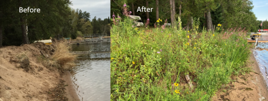 Before and After: Shoreline restoration at Bill & Pat Harwell property
Expanded update is here!

The 2020 update of the Floodplain Management in Minnesota Quick Guide has arrived. If you liked the 2018 version, you'll like this this version even better!
The Quick Guide is filled with useful graphics and targeted at local officials and other professionals involved in floodplain management, as well as landowners.
|
How to get a copy:
See the May 2020 Water Talk article on updates included in the 2020 Quick Guide. See the Winter 2019 Water Talk article on the original 2018 Quick Guide for a summary of other content in the original Quick Guide that is also included in the 2020 Quick Guide update.
Note: FEMA has currently put new Letters of Final Determinations and beginning new 90-day appeal periods on hold due to COVID-19.
Actual, scheduled, and anticipated dates since May 2020 Water Talk:
Preliminary Maps
- Olmsted County (panels) - May 29, 2020
- Lake of the Woods County - May 29, 2020
- Pope County - May 29, 2020
- Stevens County - May 29, 2020
- Koochiching County - July 9, 2020
- Anticipated during 2020: Blue Earth (panels), Carlton, Dodge, Itasca , Le Sueur, Lyon (panels), Morrison, Pipestone, Rock and Wabasha Counties
Local Officials Meetings & Open Houses
- Pennington County - Local Official Meeting (virtual); June 17, 2020
- Rice County (panels) - Local Official Meeting (virtual); July 16, 2020
- Watonwan County - Local Official Meeting (virtual); August 2020 (anticipated)
- Olmsted County (panels) - Local Official Meeting (virtual); September 2020 (anticipated)
90-Day Appeal Periods
- Cottonwood County - July 15 to October 13, 2020
Letters of Final Determination (LFDs)
- Scott County - August 12, 2020 (anticipated)
- Red Lake County - September 9, 2020 (anticipated)
- Wright County - September/October 2020 (anticipated)
- Marshall and Yellow Medicine Counties - By end of 2020 (anticipated)
Effective (6 months after LFD date)
None currently
Additional Map Update Information:
|
