|
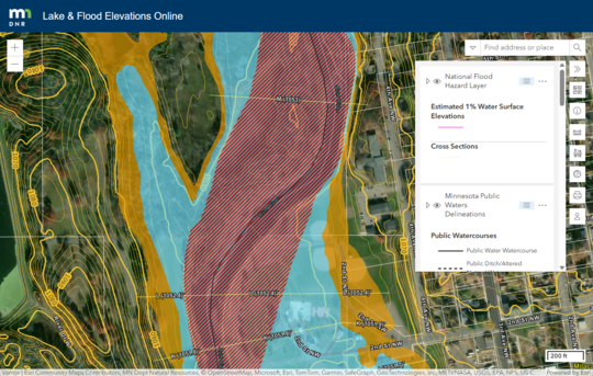
During the week of May 18, 2026, DNR's Lake & Flood Elevations Online (LFEO) viewer was moved to a new platform!
Verify your "favorites" bookmark is linked to the updated site
If you are a regulator user of the LFEO viewer, double-check your favorite link. (Hint: You'll know you have the correct link if the web address starts with "lfeo" versus the previous site's "arcgis.")
We are working on updating links from the DNR webpages, but if you see old links in the future, or have suggestions for future updates, please advise DNR staff at floodplain.dnr@state.mn.us.
 What's changed?
Overall, you shouldn't notice many changes. The new platform should load a bit faster and will be more stable into the future. A few changes you may notice:
- The 2-foot contours and the parcel layers are off in the default view (though the 10-foot contour layer is on). Click the "eyeball" icon next to the layer of interest to turn it off or on.
- Most of the symbology was retained, but you may see subtle changes. For example, the parcel layer is now white (versus the previous light green).
- The parcel ID callout box has a docking option that moves that box to the right, so it doesn't cover part of the parcel. Look for a rectangular icon in the upper right - if hovering it will say "Dock." (The basin callout boxes have had the same docking option.)
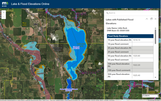 More information about the LFEO viewer
-
- A useful tool that was not noted in the above article is the latitude/longitude tool. Select the globe icon, then select your location of interest. The latitude/longitude will be shown in a callout in the lower left portion of the screen. If you hover over the callout box, you'll see a copy option on the right side. Use the expand arrow on the right side to see conversion options.
By Dan Petrik, DNR Shoreland and Rivers Program Manager
A new Minnesota law regulating homeowners associations (HOAs) does not affect local administration of shoreland rule Planned Unit Development (PUD) requirements related to HOAs and open space management.
Recent Minnesota law change
SF 1750, also known as the “Homeowners Association Bill of Rights,” was recently signed into law by Governor Walz. This law includes broad consumer protections and limits on homeowners association practices. One of the key elements of the law are provisions that, except as required by state or federal law or rule, prohibit local governments from conditioning approval of a residential building permit, conditional use permit, subdivision development, or PUD on the:
- Creation of a homeowners association
- Inclusion of any service, feature, or common property necessitating a homeowners association, unless requested by the developers
- Inclusion of any terms in HOA legal documents, or
- Adoption or revocation of local regulations governing HOAs or its members
Law does not affect shoreland PUD requirements
This law does not affect county, city, and township administration of shoreland PUD requirements because state shoreland rules (6120.3800 subp. 5. C) require HOAs to preserve and maintain open space according to specific provisions in rule.
Local governments with shoreland should review their shoreland ordinances to make sure they are consistent with this rule. The long-term protection and maintenance of open space by HOAs is a critical element of the state shoreland program. The shoreland rules allow higher density in shoreland areas as a tradeoff for the long-term protection of open space.
For more information, see the League of Minnesota Cities article Homeowners Association, Common Interest Community Reform Bill Sent to Governor for Signature - League of Minnesota Cities
|
Have you used the DNR MNTOPO site in the past, or wondered how to see LiDAR data in Minnesota? We are excited to announce that MnTopo 2 is now live (as of the week of May 18, 2026)!
Note that the site is still going through updates.
What about MNTOPO (or MNTOPO 1)?
The previous MNTOPO site is no longer available. That link will give an error message. Many of the features that had been on the MNTOPO 1 site have been incorporated in MNTOPO2.
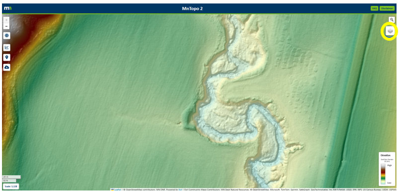 Layers available in MNTOPO2
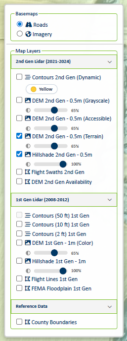
Expand the layers panel icon in the upper right to see the layer options. The image below shows which layers are turned on in the default view.
-
Roads or imagery background: Note the imagery option only appears at 100 feet or bigger scales.
-
2nd Gen Lidar (2021-2024):
- 1-foot contours - Note these are drawn dynamically. (We anticipate a future static layer that would be the authoritative layer.)
- Clicking the Contours 2nd Gen color icon changes the contour colors. Choices are black, red and yellow.
- DEM layer options
- Flight swaths (shows collect date, metadata links, etc.)
- Areas of 2nd Gen DEM availability
-
1st Gen Lidar (2008-2012):
- Contours at 50 feet, 10 feet and 2 feet
- DEM 1 meter
- Hillshade
- Flight lines (shows flight date, metadata links, etc.)
- FEMA floodplain - 1% annual chance floodplain (pinkish for digital FEMA maps and yellowish for paper FEMA maps). Floodway and 0.2% annual chance floodplain layers are not included.
-
Reference Data
|
Tools in MNTOPO2
The following tool icons are in the upper left part of the site:
-
Globe icon: Zooms to full Minnesota view.
-
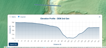
Graph icon: Create an elevation profile (see example "Elevation Profile - DEM 2nd Gen" clip). Select the starting and ending points, and the elevation profile will appear showing elevations versus relative distances along the line selected. Note the "Export CSV" box below the profile.
|
-
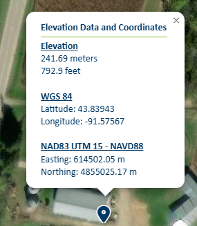
Location pin icon: See Elevation Data and Coordinates for a selected spot. Elevation, Latitude/Longitude and UTM coordinates are shown for that spot.
-
Cloud download icon: After selecting the icon you will be directed to start drawing a shape encompassing your area of interest. A download options box will appear. Note: This feature is a work in progress.
|
By Ceil Strauss, DNR, State Floodplain Manager
The FEMA Review Council had their last official meeting on May 7, 2026. At that meeting they presented a summary of the recommendations in their final report. You can see the presentation slides on the FEMA Review Council Final Meeting Documentation page.
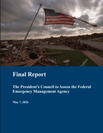
- You can see the May 7, 2026 Final Report – The Present’s Council to Assess the Federal Emergency Management Agency and links to past meetings and related information on the FEMA Review Council page.
- Most of the guiding principles and recommendations are related to disaster response. Guiding Principle #7 – Reform the FEMA National Flood Insurance Program for Financial Stability and Risk Resilience – covers many flood insurance recommendations and two recommendations related to our floodplain management and flood risk mapping programs: Empower Communities (Better Land-Use Policies) & Modernize Risk Assessment (Update Risk Rating 2.0 & Improve Maps). (See page 47 in the report.) These recommendations have little detail, so we’ll be watching what direction the follow up goes.
- Note that public comments are being received through June 8, 2026.
|
Media stories and comments by organizations
Follow up steps
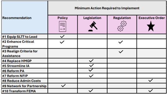
Most of the recommendations will require legislation, updated formal policy and regulations, or a combination to go forward. The following summary table that was in the final report (and the presentation slides) is helpful.
The DNR floodplain staff - as well as those in other state agencies like the Department of Public Safety Division of Homeland Security and Emergency Management - will continue to monitor future actions and proposed legislation and rules. Many of the potential future changes could have a big impact on the state.
The Minnesota Humanities Center (MHC) and the Minnesota Pollution Control Agency (MPCA) are pleased to announce that the application to host a We Are Water MN exhibition during the 2027 and 2028 tour is now open.
What is "We Are Water MN"?
“We Are Water MN” is a partnership-building and community engagement program that deepens connections between Minnesotans and the water we rely on through a traveling exhibit throughout the state. Each year, five host sites are selected to display the exhibit and engage community members with its content and one another over a seven-week period. This exhibit, coordinated by MHC and the MPCA, guides visitors through the community’s relationship with water—how it is used, conserved, and protected. Host sites also work in partnership with other sites as the exhibit travels throughout the state.
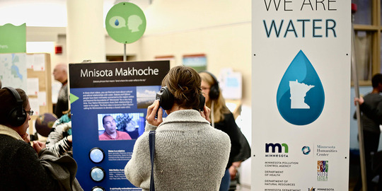 We Are Water event
How to apply
The strongest host community applicants will describe how they intend to leverage hosting We Are Water MN to build new partnerships and connect with their communities through public events and activities. Applications are due by midnight on May 31, 2026.
We strongly recommend that host sites:
- Have at least 1,000 square feet to allocate for the We are Water MN Exhibition.
- Have at least three paid staff members who can participate on the planning team. Please note that these members may be from different partner organizations committed to working together to host the exhibit.
Organizations will be reimbursed up to $10,000 for expenses related to hosting the exhibit and community outreach events, and decisions will be made by July 17. While we are primarily seeking hosts for the 2027 tour, we are accepting proposals to host in 2028 for those sites that need a longer planning runway.
APPLY HERE by May 31.
Please feel free to share this call for exhibit hosts with individuals or organizations that would appreciate the opportunity.
Current and upcoming "We Are Water MN" locations in 2026
- April 23 - June 14 - St. Paul (Capital Region Watershed District)
- June 18 - Aug. 10 - Itasca (MN DNR Itasca State Park)
- Aug. 13 - Oct. 5 - Little Falls (Great River Arts)
- Oct. 8 - Nov. 30 - Blaine (Anoka County Library)
See We Are Water MN for more details.
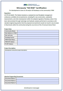
We have two new forms to assist local floodplain managers and those involved in designing new/replacement culverts and bridges, or any other type of filling, grading, etc. in the floodway or FEMA flood zones where the floodway has not been delineated.
The previous Minnesota "No Rise" certification form was created in 2004, and closely followed a FEMA sample form. MN DOT staff recently created fillable pdf "No Rise" and "Allowable Rise" certification forms for their projects. When DNR floodplain staff saw those forms we agreed they were very helpful - and a big improvement over the old 2004 form - so developed versions that could be used for all projects in Minnesota.
Floodway versus flood fringe versus general floodplain
To learn more about "floodway" versus "flood fringe" see:
"No Rise" certification form
Where used?
In floodway zones (i.e., the floodway portion of FEMA Zone AE floodplains, or detailed study areas).
Why/how used?
- Federal and state floodplain regulations require that any form of development - including filling, grading, new and replacement culverts/bridges, installing any man-made structures, etc. - meets the "No Rise" requirement.
- A professional engineer must certify the proposed development will not cause any (0.00 feet or less) increase in the 1% annual chance flood elevation.
- The "No Rise" certification form is the preferred method for documenting that proposed floodplain development will not cause a higher increase in the flood elevation than allowed. Supporting modeling and/or other documentation (such as meeting "standard engineering practices") must be attached.
|
"Allowable Rise" certification form
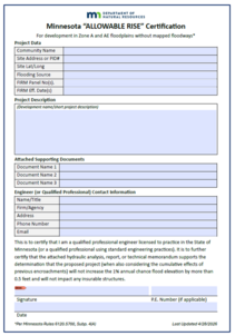
Where used?
- In FEMA Zone AE (detailed study zones) where no floodway has been delineated.
- In FEMA Zone A (where no detailed study has been done).
Why/how used?
- Federal and state floodplain regulations require that any form of development - including filling, grading, new and replacement culverts/bridges, installing any man-made structures, etc. - be evaluated to to verify the proposed floodplain development won't cause a higher increase in the 1% annual chance flood elevation than allowed.
- A professional engineer or other qualified professional must certify the proposed development will meet the allowable cumulative rise in the 1% annual chance flood elevations:
- Up to 0.5 feet, as long as there is no increased flood damage potential (i.e., no existing insurable buildings are in or touching the floodplain with the increase).
- If existing insurable buildings would be impacted, the increase is reduced so the buildings are not touched.
- Certification that the proposed development doesn't cause more of an increase in the 1% annual chance flood than allowed must be submitted with the permit application. In the past we have not had a standard form for submitting that certification/documentation. It is now recommended that this Allowable Rise form be used and that the supporting modeling and/or other documentation (such as meeting "standard engineering practices") be attached.
|
The updated floodplain informational sheet “Basements and Lowest Floors in the Flood Fringe of the Floodplain” is now available.
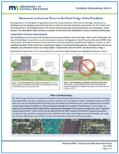
- The March 2026 informational sheet on basements and lowest floors replaces the August 2010 version.
- The new version has been expanded from two to four pages, has new graphics and meets the current accessibility standards.
- We hope it is helpful and welcome comments on any portion that is not clear. Send comments to floodplain.dnr@state.mn.us.
|
The new floodplain informational sheet “Residential Accessory Structures in the Flood Fringe of the Floodplain: Sheds, Detached Garages and Other Structures” is now available.
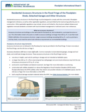
- The April 2026 informational sheet is new. It is a topic we’ve discussed turning into an information sheet for a long time.
- We hope it is helpful and welcome comments on any portion that is not clear. Send comments to floodplain.dnr@state.mn.us.
|

The Association of State Floodplain Managers (ASFPM) is the premiere national association for all topics related to floodplain management, flood risk identification/mapping, flood risk reduction and community resilience.
The ASFPM annual conference will be relatively nearby in neighboring Wisconsin in spring 2026, so we hope to see many attendees from Minnesota.
The conference will be on the shores of Lake Michigan in Milwaukee, Wisconsin for a landmark event—ASFPM’s 50th Annual National Conference, themed: “The Fresh Coast Legacy: 50 Years of Floodplain Management.” Taking place May 31 – June 4, 2026, this milestone event celebrates five decades of progress in flood risk reduction and community resilience across the nation.
For more information
See the ASFPM 2026 conference website for more details and to watch for updates.
Registration is open.
|

Have a tricky floodplain management situation? Want to get the latest timing for FEMA map updates?
Talk with FEMA and DNR Floodplain Program representatives during monthly virtual Minnesota Floodplain Management Office Hours. Hours are 10-11 a.m., typically on the fourth Thursday of the month (but a few are adjusted to avoid holidays, etc.).
Upcoming monthly hours (Note: all are 10 a.m. - 11 a.m. Central Time)
Where: Teams. No registration is required. Select a date to see a Teams meeting and join us.
These office hour dates and links are also available on the DNR Floodplain Training and Education page.
|
Important Dates to Note:
(since April 2026 Water Talk and upcoming in next couple months)
|
|
 |
Preliminary Maps
None
Local Officials Meetings and Open Houses
Note: Many of these meetings were postponed due to the federal partial shutdowns and the inability of FEMA representatives to attend.
- Anoka Countywide (outside Mississippi HUC8) Kickoff - 11 a.m., June 30, 2026
- Dodge County Better Data LOMR Flood Risk Review - 1 p.m., July 21, 2026
- Rock County Revised Prelims Flood Risk Review - July/August 2026
- Twin Cities HUC-8 Flood Risk Review (Capitol Region, Ramsey Washington, South Washington, and Vadnais Lakes) - July/August 2026
- Twin Cities HUC-8 Flood Risk Review (Coon Creek) - August/September 2026
- Twin Cities HUC-8 Flood Risk Review (Rice Creek) – August/September 2026
90-Day Appeal Periods
None
Letters of Final Determination (LFDs)
- Olmsted Countywide (Rochester Levee) - Dec. 10, 2025
- Wabasha Countywide - Jan. 21, 2026
Effective (Six months after LFD date)
- Olmsted Countywide (Rochester Levee) - June 10, 2026
- Wabasha Countywide - July 21, 2026
Additional Map Update Information:
|