|
The first of our spring blooms have arrived! As the weather warms up you may be contemplating expanding your garden or adding a new garden featuring native plants beneficial for pollinators. Some resources to check out:

- See last month's Water Talk article Thinking About Spring Planting? It included links to many resources for choosing native plants for your conditions (sunny, shady, shoreline, etc.) and general resources for planting native plants.
- See the video of a webinar on Native Plants and Pollinators DNR hosted last summer featuring: Metro Blooms on "Native Plantings for Pollinators," DNR's pollinator program on "Pollinator Conservation in Minnesota" and Carlton County Soil and Water Conservation District (SWCD) on "Carlton SWCD - A Pollinator Powerhouse!" The three speakers covered many helpful resources and ideas for native plantings, with an emphasis on pollinators.
|
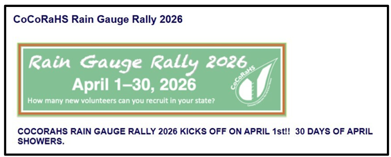
 If you like weather and winning, CoCoRaHS is for you!
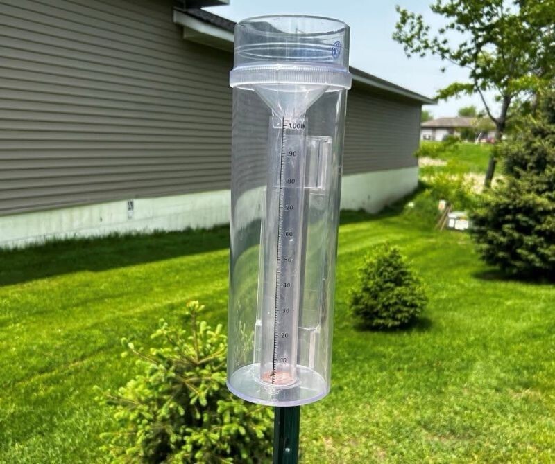
The Community Collaborative Rain, Hail and Snow Network has more than 20,000 volunteers nationwide who measure precipitation in their backyards using a standard 4-inch-diameter rain gauge.
For the past six years, Minnesota has won the CoCoRaHS Cup for recruiting the most new volunteers of any state during the Rain Gauge Rally recruitment campaign.
All you need to do to help us keep the CoCoRaHS Cup in Minnesota (and most importantly, gather good data about rainfall amounts and climate trends) is sign up and provide or purchase a 4-inch rain gauge at CoCoRaHS.org
With a goal of recruiting 350 or more new rainfall monitors, we invite you to join today! Watch as the numbers grow during the month of April on this Rain Gauge Rally live scoreboard competition between states!
 Make the drops of rain count
There is always a need for a greater number of rainfall monitors in the state. Rain, snow, and hail do not fall the same in an area. Amounts measured can be quite different only a short distance away. Help fill in the gaps by joining us. The more volunteers reporting what happened at their home, the better we know where it did and did not rain.
Volunteer as a rainfall monitor for the Community Collaborative Rain, Hail and Snow Network (CoCoRaHS) coordinated through the state climatology office in the Minnesota Department of Natural Resources. Once you join, your precipitation observations will start showing up daily on our county maps. You will also provide a great service to your community by allowing your friends, neighbors, scientists and others to see how daily precipitation has covered the state. Your reports make a difference!
 To become a rainfall monitor, you must:
- Have internet access to submit reports by computer or using the CoCoRaHS Observer weather app on your smartphone
- Provide or purchase a standard 4-inch rain gauge (approved official rain gauges discounted here through CoCoRaHS)
- Complete online training on how to observe weather trends and how to submit precipitation and weather event reports online
- Commit to submitting reports for at least one season (3 months)
Volunteers are particularly needed in Greater Minnesota outside the Twin Cities metro area. Some areas have very few reporting stations so the more we have across the state, the better information we have to work with.
To sign up:
Coordination with FEMA staff: Since FEMA is within the Department of Homeland Security (DHS), the partial federal government shutdown continues to impact FEMA programs. Although many FEMA staff have other funding and continue to work during the partial shutdown, very little communication has been allowed with the states and local governments.
As of this week, some FEMA contractors have started communicating with DNR staff and others about some projects and program areas.
FEMA Review Council: The FEMA Review Council has been continued to May 29, 2026 (or 10 days after the required report is submitted to the President, if earlier) based on an Executive Order issued March 24, 2026. The next FEMA Review Council meeting is reported to be May 7, 2026, however we have not yet found online confirmation of the meeting information.
FEMA Grants: The DHS had been requiring that the DHS Secretary sign off on any grant exceeding $100,000. Under the new DSH Secretary, Markwayne Mullin, this requirement is no longer in place. Hopefully that change will result in a faster grant approval process.
Future updates: DNR staff will continue to monitor changes with FEMA staff, contractors and grants.
By Dan Petrik, DNR Shoreland and Rivers Program Manager
The DNR has finished and emailed the 2025 Shoreland Activities Report to all 85 counties with zoning authority. This annual report compiles survey responses from the 85 counties on their shoreland ordinance management activities in 2025. The report tracks and summarizes trends on:
- Construction and land alteration permits
- Development activity
- Variance activity, and
- Townships taking on zoning
There is a lot of information in the report but following are some highlights.
Land alternation in the shore impact zone
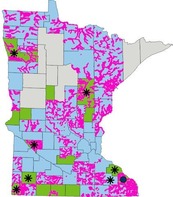
73 counties require a land alteration permit for projects moving more than 10 cubic yards (CY) of material in the shore impact zone (SIZ). The 12 counties that do not require such a permit should review their shoreland ordinance for this provision as it is required for all local government shoreland ordinances. If your local ordinance does not include this provision, please add it. See Section 8.32 B. (1) of the model ordinance. |
|
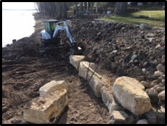 |
Riprap projects
For the 73 counties requiring a land alteration permit for moving more than 10 CY of material in the SIZ, there is significant variation as to what is considered “material” for a riprap project as counting towards the 10 CY threshold.
- 71 counties count earth material moved or graded prior to laying riprap
- 55 counties count rock riprap
- 49 counties count crushed rock filter.
The DNR considers all three of these “materials” to count towards the 10 CY threshold and encourages all counties to make the same determination. Riprap projects, while they play an important shoreline erosion role, can be very destructive to shoreline habitat. Including all of the above material as counting toward the 10 CY threshold will result in more riprap projects being evaluated and reviewed through a local permit, hopefully resulting in fewer environmental impacts.
For more information
The 2025 Shoreland Activities report can also be found on the DNR website.
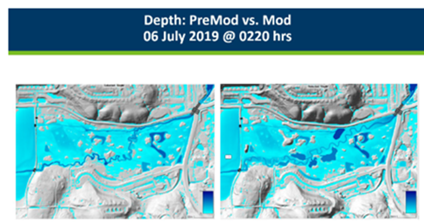
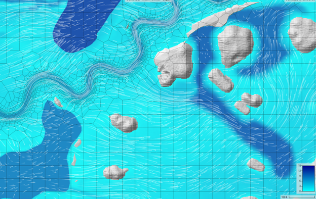 Dan Reinartz and Salam Murtada, DNR Ecological and Water Resources Division hydrologists, recently used advanced modeling software to create a hydrologic and hydraulic model for a post-project review of the Cascade Creek stream restoration in Rochester.
These models, which compare channel and floodplain performance before and after restoration, are essential to helping stakeholders understand the project's benefits and values.
The hydrologists used the Hydrologic Engineering Center's River Analysis System (HEC-RAS, as it's known by most practitioners) which incorporates detailed two-dimensional hydraulic calculations for natural and constructed channels, and a georeferenced terrain mesh of culverts, bridges and land cover data to inform the model and accurately simulate flow conditions; and a rainfall runoff model, which supported the previous model by developing flows to drive it.
Dan and Salam reproduced the historic runoff recorded in July 2019, as well as simulating potential two-year and 10-year events, which are of special interest to stream practitioners. The analysis of the restored creek showed it is well connected to the floodplain, reducing in-channel stream velocities, shear stress and stream power, which are meaningful factors of sediment transport and stream stability. The tool also helped the team find areas which still experience higher shear stress, which can help with the proactive management and development of continued channel restoration.
See YouTube video
The model results are posted on YouTube with a narrative explanation, informing and connecting stakeholders with the restoration's effects. See the Cascade Creek: 05 July 2019 Event video (less than four minutes). Modeling comparisons of depth, velocity and sheer stress are simulated.
 For more information
These models can also be used in the design process to anticipate sediment transport, stormwater pipe networks, and water temperature and water quality.
For more details about the modeling options in general, or the Cascade Creek project, contact Dan Reinartz or Salam Murtada.

The Association of State Floodplain Managers (ASFPM) is the premiere national association for all topics related to floodplain management, flood risk identification/mapping, flood risk reduction and community resilience.
The ASFPM annual conference will be relatively nearby in neighboring Wisconsin in spring 2026, so we hope to see many attendees from Minnesota.
The conference will be on the shores of Lake Michigan in Milwaukee, Wisconsin for a landmark event—ASFPM’s 50th Annual National Conference, themed: “The Fresh Coast Legacy: 50 Years of Floodplain Management.” Taking place May 31 – June 4, 2026, this milestone event celebrates five decades of progress in flood risk reduction and community resilience across the nation.
For more information
See the ASFPM 2026 conference website for more details and to watch for updates.
Registration is open.
|

Have a tricky floodplain management situation? Want to get the latest timing for FEMA map updates?
Talk with FEMA and DNR Floodplain Program representatives during monthly virtual Minnesota Floodplain Management Office Hours. Hours are 10-11 a.m., typically on the fourth Thursday of the month (but a few are adjusted to avoid holidays, etc.).
Upcoming monthly hours (Note: all are 10 a.m. - 11 a.m. Central Time)
Where: Teams. No registration is required. Select a date to see a Teams meeting and join us.
These office hour dates and links are also available on the DNR Floodplain Training and Education page.
|
Important Dates to Note:
(since March 2026 Water Talk and upcoming in next couple months)
|
|
 |
Preliminary Maps
None
Local Officials Meetings and Open Houses
Note: Many of these meetings are being postponed due to the federal partial shutdowns and the inability of FEMA representatives to attend. Once the shutdown has ended it will be at least a month before meetings will be scheduled since at least a few weeks lead time is expected to be provided.
- Anoka Countywide (outside Mississippi HUC8) Kickoff - June/July 2026
- Rock County Revised Prelims Flood Risk Review - June/July 2026
- Dodge County Better Data LOMR Flood Risk Review - June/July 2026
- Twin Cities HUC-8 Flood Risk Review (Capitol Region, Ramsey Washington, South Washington, and Vadnais Lakes) - June/July 2026
- Twin Cities HUC-8 Flood Risk Review (Coon Creek) - June/July 2026
- Twin Cities HUC-8 Flood Risk Review (Rice Creek) –June/July 2026
90-Day Appeal Periods
None
Letters of Final Determination (LFDs)
- Olmsted Countywide (Rochester Levee) - Dec. 10, 2025
- Wabasha Countywide - Jan. 21, 2026
Effective (Six months after LFD date)
- Olmsted Countywide (Rochester Levee) - June 10, 2026
- Wabasha Countywide - July 21, 2026
Additional Map Update Information:
|