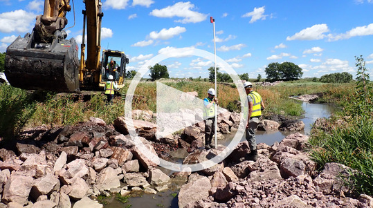
 This 14-minute video highlights the restoration of Mound Creek in Blue Mounds State Park to explain stream restoration science, methodology, and goals. The south dam on Mound Creek within the park failed during a large rain event in June 2014.
After considering the options based on ecological, recreational and economic factors, the remnant dam features were removed and the stream was restored in 2019 with a focus on re-establishing stream function and stream health.
Minnesota Department of Natural Resources staff from Parks and Trails and Ecological and Water Resources talk about decisions made on behalf of the state park and its users and the ecological benefits. They also describe the science and methodology involved in river restoration, in addition to the range of expertise and collaboration involved in these large, complex projects where success is reflected in improved ecological health and biodiversity.
Watch the Mound Creek Restoration at Blue Mounds State Park video
After another lower snow winter, we have a low probability of spring runoff flooding. But that doesn't mean we can forget about flooding until next spring! In recent years, we've been rotating between flash droughts and intense storms leading to flooding. ("Flash droughts" only became part of my vocabulary in the last few years.)
Consider flood insurance

Over 96% of Minnesotans live in communities that participate in the National Flood Insurance Program (NFIP), and anyone in an NFIP community can purchase flood insurance.
-
Available in all FEMA map zones. One common myth is that you can only purchase flood insurance if you are in the FEMA mapped floodplain. Fact: You can purchase flood insurance in any flood zone. You may be close to a FEMA mapped zone, or you may be in or near flooding sources FEMA did not map, or in a lower area than the surrounding lands and impacted by intense rain runoff (or urban flooding).
|
-
When is flood insurance mandatory? When the building is in or touching the FEMA mapped floodplain, and you have a federally backed loan, it is mandatory. But even after that loan is paid off, we encourage retaining flood insurance.
-
Choose the amount of coverage for your flooding situation. If you don't have the mandatory flood insurance, you can choose the amount of coverage you want and keep the premium lower.
-
Waiting period. There is a 30-day waiting period for the policy to be effective, so don't wait. (The exceptions: No waiting period for new loans, and one day waiting period within 13 months of new FEMA maps.)
-
Not sure if your community participates in the NFIP? Check the Minnesota Community Status Book. Note that if you are outside city boundaries, your county is your community (except for those in a few townships that are the floodplain zoning authority), and all our counties with areas outside cities (or participating townships) participate.
Flood insurance resources:
Helpful Sites to Check River Gages and Flooding Forecasts
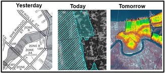
The National Weather Service (NWS) released their National Weather Prediction Service (NWPS) site about a year ago. See our June 2024 Water Talk article Checking River Gages and Flooding Forecasts to learn more about the NWPS site and get some user hints.
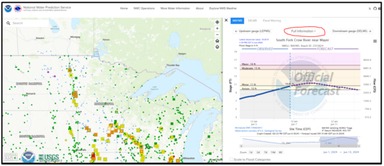 National Weather Prediction Service site for Minnesota in June 2024 and sample forecast graph at a gage site on South Fork of Crow River near Mayer
The DNR/MPCA Cooperative Stream Gaging Program site has additional gage sites around Minnesota.
- Click on a gage to see a window with a summary and a link to see more details (the icon in the lower left).
- Once at the details page, see gage location, summaries and data download options. Scroll down to see recent gage elevations. Note that you can adjust the period of record in the graph.
Community Resources to Get Prepared
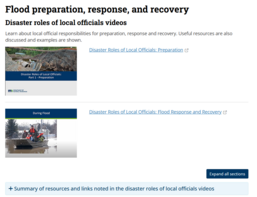
See DNR Preparation, Response and Recovery page for links to many resources available from the DNR and other agencies.
By Lori Blair, Executive Director, Minnesota Rural Water Association
What is MnWARN?
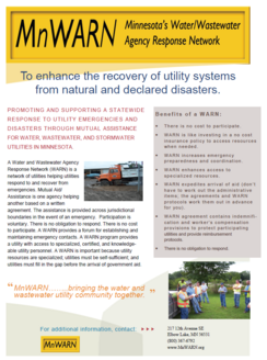
Water and Wastewater Agency Response Network (WARN) is a network of utilities helping utilities respond to and recover from emergencies. Mutual Aid/Assistance is one agency helping another based on a written agreement. The assistance is provided across jurisdictional boundaries in the event of an emergency. Participation is voluntary and there is no obligation to respond. There is no cost to participate. A WARN provides a forum for establishing and maintaining emergency contacts. A WARN program provides a utility with access to specialized, certified and knowledgeable utility personnel. A WARN is important because utility resources are specialized; utilities must be self-sufficient; and utilities must fill in the gap before the arrival of government aid.
|
How does MnWARN work?
For years, communities that experience utility problems have been on their own, left to face uncertainties. Every now and then, a situation would arise that would require additional help or guidance. Usually, utilities would think this emergency is what would happen to another community.
Emergencies don’t happen everyday – in fact, they don’t happen every year. When a disaster does occur, it can be catastrophic. Sometimes, it can mean the demise of the community or, at least, the impact is so severe that community leaders will ponder the future of their community.
This is where MnWARN can be of assistance. MnWARN is a formal emergency response program in which utilities have signed a mutual aid agreement whereby water, wastewater, and stormwater utilities sustaining physical damage from natural or man-made disasters can obtain emergency assistance in the form of personnel, equipment and materials. The goal is to provide essential services necessary to protect the health and welfare of the utilities' customers.
How to join MnWARN
Membership Information Form, Mutual Aid Agreement, Resolution, and sample equipment schedule of fees can be found online at www.MnWARN.org under the Participation link.
Don’t wait until disaster strikes. Join MnWARN today!
More information:

The City of Vergas and Otter Tail County recently signed a memorandum of understanding (MOU) for the county to take over day-to-day shoreland permit administration for the city. Vergas (pop. 348), in northern Otter Tail County, is a small city that claims the world’s largest loon. Vergas is surrounded by three lakes in lake-rich northern Otter Tail County. Like many small cities, the city clerk/treasurer administers the zoning code, among many other responsibilities. The city administers only 10 – 15 shoreland zoning permits per year, not enough for staff to become proficient in shoreland administration. To free up staff time for other tasks, the City of Vergas approached Otter Tail County to see if they would take over day-to-day shoreland permitting administration.
|
With county board and city council support, county and city staff worked together to develop a cooperative arrangement. During discussions, staff determined that the best approach would be for the city to adopt the county’s shoreland ordinance with an addendum for city-specific shoreland standards such as structure height. Citizens attending public hearings held for the city adoption of the county ordinance were supportive of the city-county cooperative arrangement. The arrangement is outlined in an MOU. Under the MOU, the county administers land use and land alteration permits in shoreland. The city administers variances, CUPs, and subdivisions in shoreland, but with technical assistance from county staff. The MOU is a pilot project that terminates after 24 months. Near the end of the agreement, the arrangement will be reviewed to determine if it will be renewed. If it is successful and renewed, other cities in Otter Tail County have said they would like similar arrangements with the county.
For more information on this effort, contact Chris Le Clair with Otter Tail County and Julie Lammers with the City of Vergas.
Related Minnesota Regulations
The Minnesota Shoreland Rules (6120.3900 Subp. 5) encourage local governments to enter into agreements with each other to jointly administer local shoreland controls. Minnesota Statutes 394.32 and 471.59 specifically authorize local government cooperation and procedures for administering local zoning.

Come learn in person and interact with other local officials and professionals involved in aspects of floodplain management (i.e., surveyors, consulting engineers/planners, Realtors, lenders/agents).
We plan to cover floodplain management basics and FEMA map basics, including a map reading and interpretation exercise. Other topics include floodplain administration basics, utilizing web-based flood maps and tools, dealing with nonconformities, making Substantial Improvement (SI)/Substantial Damage (SD) determinations, and community post-disaster responsibilities.
These trainings are free.
|
Registration information is available via a link at the top of our training page. You may also use the direct registration links for the dates/locations below.
-
Brainerd: Tuesday, April 1, 2025, 9 a.m. – 4 p.m. (8:30 registration), Crow Wing County Government Center (Land Services Building), 322 Laurel Street, Brainerd | Register
-
Cambridge: Thursday, April 3, 2025, 9 a.m. – 4 p.m. (8:30 registration), Cambridge Public Library, 111 Dellwood Street N, Cambridge | Register
-
Apple Valley: Wednesday, April 9, 2025, 9 a.m. – 4 p.m. (8:30 registration), Dakota County Western Service Center, Room 106, 14955 Galaxie Avenue, Apple Valley |Register
Continuing Education Credits (CECs) may be obtained by Certified Floodplain Managers (CFM).
The National Flood Insurance Program (NFIP) has now had over 30 extensions since the last five-year extension that expired Sept. 30, 2017. The latest extension was set to expire March 14, 2025, but the NFIP’s authorization was extended to Sept. 30, 2025.
FEMA's Congressional Reauthorization for the NFIP page should have the latest updates. FEMA reports that they and Congress have never failed to honor the flood insurance contracts in place with NFIP policyholders. Should the NFIP’s authorization lapse, FEMA would still have authority to ensure the payment of valid flood claims with available funds.
|
|
Should the authorization lapse, however, FEMA would stop selling and renewing policies for millions of properties in communities across the nation. Nationwide, the National Association of Realtors estimated in 2017 that a lapse might impact approximately 40,000 home sale closings per month.
|
|
|
 |

Got questions about the Federal Flood Risk Management Standard or some other state or federal requirement? Have a tricky floodplain management situation?
Talk with FEMA and DNR Floodplain Program representatives during monthly virtual Minnesota Floodplain Management Office Hours. Hours are 10-11 a.m., typically on the fourth Thursday of the month (but a few are adjusted to avoid holidays, etc.).
Upcoming monthly hours (Note: all are 10 - 11 a.m. Central Time)
Where: Teams. No registration is required. Select a date to see a Teams meeting and join us.
These office hour dates and links are also available on the DNR Floodplain Training and Education page.
|
Important Dates to Note:
(since January 2025 Water Talk and upcoming in next couple months)
|
|
 |
Preliminary Maps
None
Local Officials Meetings and Open Houses
- Rainy River Better Data Letter of Map Revision Flood Risk Review: 1-2 p.m., April 15, 2025
90-Day Appeal Periods
None
Letters of Final Determination (LFDs)
None
Effective (Six months after LFD date)
- March 11, 2025 - Itasca Countywide
- March 25, 2025 - St. Louis Countywide
Additional Map Update Information:
|