Come learn in person and interact with other local officials and professionals involved in aspects of floodplain management (i.e., surveyors, consulting engineers/planners, Realtors, lenders/agents).
|
Details
- When: 6/13/2024, Thu, 9 am – 4 pm (8:30 registration):
- Where: Blaine City Hall (Cloverleaf Room), 10801 Town Square Drive NE, Blaine
-
Register | Registration information is also available via a link at the top of our training page.
- Cost: Free!
- What: We’ll cover floodplain management basics and FEMA map basics, including a map reading and interpretation exercise. Other topics include: floodplain administration 101, utilizing web-based flood maps and tools, dealing with nonconformities, and making Substantial Improvement (SI)/Substantial Damage (SD) determinations.
If you have any questions, contact Ceil Strauss or floodplain.dnr@state.mn.us.
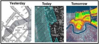
See National Weather Service (NWS) site for current and forecasted river levels
The map below is from the new National Weather Prediction Service (NWPS) site that was released in late March 2024. (Note: The former Advanced Hydrologic Prediction Service (AHPS) site is no longer available as of May 28, 2024.)
- The river gages have color coded circles showing current flood stages (see the legend to the right in the default view).
- River gages with forecasting capability have a square around the circle. The color in the square (outside of the circle) shows the forecasted flood stages.
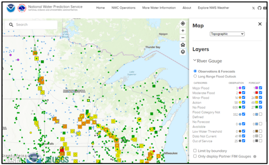
- Click on a gage to see a pop out summary page. Click on the “Full Information” box in the top center of the pop out page to see listing of flood impacts at given gage elevations, historic crests, etc. (similar to what you could see in the previous AHPS site).
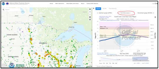 See "Full Information" for a gage
See details on historical gage levels and related data for that site:
- Option to drag the period of record being viewed and see up to a month earlier
- Flood level triggers shown
- Flood impacts listed (level of detail varies)
- Historical peaks listing
|
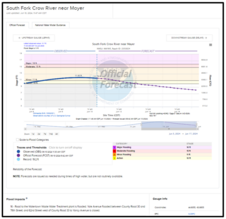
Remember: Flood level triggers are based on damage (not the regulatory flood elevations)
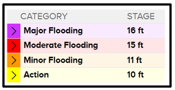
Note that the Major, Moderate and Minor Flooding triggers are based on the damages and disruption seen at those river levels. Those triggers are not the same as the "100-year" or "500-year" flood elevations; major flooding can occur at elevations above or below the "100-year" flood elevations used for regulatory purposes.
|
For more information:
- The new NWS site see:
- The DNR/MPCA Cooperative Stream Gaging Program site has additional gage sites around Minnesota.
- Click on a gage to see a window with a summary, and a link to see more details (the icon in the lower left).
- Once at the details page, see gage location, summaries and data download options. Scroll down to see recent gage elevations. Note that you can adjust the period of record in the graph.
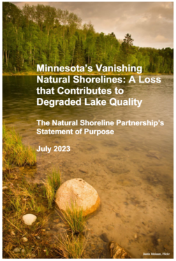
The July 2023 report titled "Minnesota's Vanishing Natural Shorelines: A Loss that Contributes to Degraded Lake Quality" was referenced in a recent virtual session with local officials and DNR staff, and we thought it would be of interest to many of our Water Talk subscribers.
This effort was the result of discussions with non-profit organizational leaders and government (state and local) natural resource professionals concerned about the continuing loss of shoreline vegetation, which helps protect clean water, habitat, lakeshore character and recreation.
The report includes discussion of:
- Benefits of natural shorelines
- Loss of water quality, water infiltration and fish/wildlife
- State of Lake shorelines in Minnesota
- Efforts to limit loss of natural shorelines
- Recommendations for future actions
|
By Salam Murtada, DNR, Floodplain Hydrologist
This example project is a recent collaboration between Olmsted County and DNR (Division of Ecological and Water resources), using the Geomorphic Approach.
The Geomorphic Approach
The geomorphic approach to bridge and culvert replacement focuses on understanding the natural processes of the river system and designing structures that work with, rather than against, these processes. In the case of County State Aid Highway (CSAH) 3 and Cascade Creek, this meant creating a bridge design that allows for natural channel migration and sediment transport while minimizing the risk of erosion and other forms of environmental degradation.

The project was partially funded by the Clean Water Cost-Share Program. This collaborative funding reflects a growing recognition of the importance of integrating infrastructure development with environmental stewardship.
Before
The previous crossing was an oversized opening consisting of three in-channel 10 x 8 foot culverts (totaling a 30-foot width channel opening). Note the sediment forming upstream of the crossing due to an oversized opening.
|
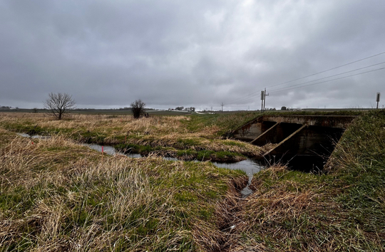 Before: Cascade Creek crossing had three 8 x 10 foot in-stream culverts. Note the sediment partically blocking two of the three culverts. (Photo credit: Olmsted County)
After
The completed replacement crossing consisted of a 16-foot wide channel opening and two 14 x 6 foot floodplain culverts. The vertical offset of the floodplain culverts is based on bankfull depth.
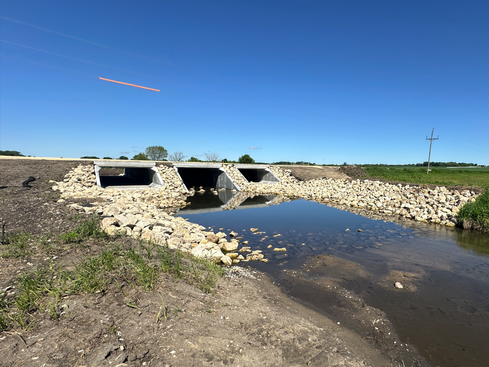 After: Cascade Creek crossing with 16-foot wide main channel opening and two 14 x 6 foot floodplain culverts. Note that more mulching and seeding will be applied. (Photo credit: Olmsted County)
For more information:
The Geomorphic Approach applies local geomorphology to design low impact/high resilient road crossings that work to improve the natural system processes. For more information about this innovative design approach, please visit the DNR Geomorphic Approach page.
If interested in applying for the grant, see Nov. 2023 Water Talk article Grant Announcement for Culvert/Bridge Replacements Using Geomorphic Approach
For information, please contact:
Salam Murtada, 651-259-5688
Kevin Zytkovicz, 651-259-5151
FEMA Region 5 staff (based in Chicago) are continuing their monthly one-hour virtual training series in 2024. They are free!
It's not too late to register for many training topics!
Upcoming "Managing your Community's Floodplain" monthly series dates and topics:

Note: All held 9-10 a.m. Central Time.
-
June 26, 2024: Floodplain Management Higher Standards; Register
-
July 31, 2024: Managing Map Changes; Register
-
Aug. 28, 2024: Resolving Potential Violations: Floodway, Low Floor, Vents; Register
-
Sept. 25, 2024: Accessory and Agricultural Structures; Register
-
Oct. 30, 2024: Great Lakes Coastal Floodplain Management; Register
-
Nov. 27, 2024: Natural and Beneficial Functions; Register
-
Dec. 18, 2024: Community Rating System; Register
These trainings and registration links are also available on the DNR Floodplain Training and Education page.
|

Talk with FEMA and DNR Floodplain Program representatives during monthly virtual Minnesota Floodplain Management Office Hours. Hours are 10-11 a.m., typically on the fourth Thursday of the month (but a few are adjusted to avoid holidays, etc.).
Upcoming monthly hours (Note: all are 10 - 11 a.m. Central Time)
Where: Teams. No registration is required. Select a date to see a Teams meeting and join us.
These office hour dates and links are also available on the DNR Floodplain Training and Education page.
|
Important Dates to Note:
(since May 2024 Water Talk and upcoming in next couple months)
|
|
 |
Preliminary Maps
None
Local Officials Meetings and Open Houses
- June 18, 2024 - Wabasha Countywide: Local Officials Meeting and Public Open House
90-Day Appeal Periods
None
Letters of Final Determination (LFDs)
None
Effective (Six months after LFD date)
- June 20, 2024 - Wilkin County panels
- June 20, 2024 - Wright Countywide
- July 17, 2024 - Le Sueur Countywide
- July 31, 2024 - Morrison Countywide
- Sept. 12, 2024 - Stevens Countywide
- Sept. 26, 2024 - Dodge Countywide
- Sept. 26, 2024 - Pope Countywide
Additional Map Update Information:
|