|
With the warmer winter so far in 2023/2024, this is a good time to revisit Minnesota data on historical duration of ice cover.
View data on ice duration trends
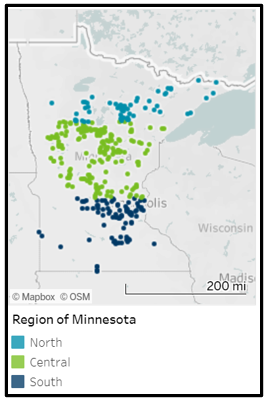
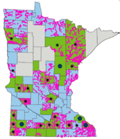
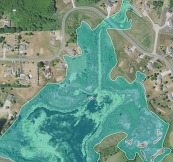
MPCA has interactive graphs showing lake ice durations over many years on their Climate Change and Minnesota's Surface Waters page. Choose the "Lake ice durations" tab at the top. The graph below shows the overall trend of lake ice duration (in days) from 1967 to 2023, with the colors representing Minnesota lakes in the north, central and south portions of the state.
You can choose to evaluate trends in the each of the three regions of the state, or for many individual lakes, over a period of record of your choice.
|
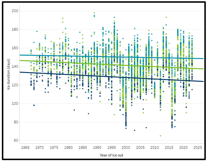
Ice duration (in days) from 1967 to 2023 shows shorter ice season in all parts of Minnesota
Note: This article is an updated portion of the longer Dec. 2021 Water Talk article Duration of Ice Cover on Minnesota Lakes Decreasing.
For more information
See more details on the following tabs of Minnesota Pollution Control Agency's Climate Change and Minnesota's Surface Waters page: Lake ice durations, Lake temperature, River flows & floods, Biological communities and FAQ.
By Craig Schmidt, National Weather Service in Chanhassen, Senior Service Hydrologist
Coming to a screen near you in late March!
The National Weather Service (NWS) plans to unveil a replacement for the decades-old river information web page called Advanced Hydrologic Prediction Service (AHPS). It will be replaced by the National Water Prediction Service (NWPS), a dynamically updating and much more detailed way to view river and water information.
Some examples of how things are changing are summarized below.
Map Updates
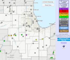
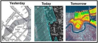
- The maps in the current Advanced Hydrologic Prediction Service (AHPS) - see example to right - are being replaced by the new format shown below.
- Observation/Forecast flood status in same icon (circle portion shows current observation and surrounding square shows forecast, if forecast site)
- Robust search and filter capabilities
- Functional legend to create specific displays for your situational awareness
- New Hazard Map - get all details for any watch/warning in effect (nationally)
|
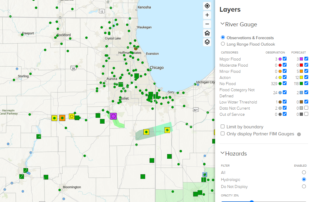
New National Water Prediction Service (NWSP) map format
Hydrograph Updates
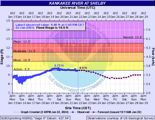
- The hydrographs in the current Advanced Hydrologic Prediction Service (AHPS) - see example to right - are being replaced by the new format shown below.
- Much faster updates. Hydrographs are produced with up to the minute data every time you click.
- One click for quick view. Second click for full details. (No mouse over yet.)
- Can look back at 30 days of observations (versus only seven days in current AHPS).
- Probabilistic graphics now on main hydrographic page (instead of separate tabs).
- New experimental National Water Model guidance. (Has a ways to go before it should be used in operations, but it is available for evaluation.)
|
New hydrograph format in National Water Prediction Service (NWPS)
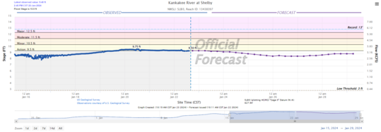
Example new hydrograph format for gage near peak
One more example of the new hydrograph at a gage with forecasting. Note in this example they are near the forecasted peak which is close to the record peak at that gage.
|
For more information

Back by popular demand!
A series of FREE one-hour virtual trainings on floodplain and shoreland management topics are being offered Dec. 2023 through March 2024. The timing will be similar to our Winter 2023 series, with most trainings offered 1-2 p.m. on Mondays, and 9:30-10:30 a.m. on Wednesdays.
Use the "Register" link next to each training to sign up.
You'll also be able to find the registration links and more details about each training on the DNR Dec. 2023 to March 2024 Upcoming Live Training page, or via the link at the top of the DNR Shoreland and Floodplain Education and Training Center.
Two new topics added
Since the December 2023 Water Talk we've added two new topics: SSTS Floodplain Regulations on March 25, 2024 and Post-Disaster Recovery: Process and Resources on April 8, 2024. See the registration links for those two new trainings in the summary of upcoming trainings below.
Upcoming dates and topics:
|
|
*New topics
-
3/6/2024 (Wed), 9:30-10:30 a.m.: Dealing with Zone As Register
-
3/11/2024 (Mon), 1-2 p.m.: Floodplain Higher Standards Register
-
3/13/2024 (Wed), 9:30-10:30 a.m.: Shoreland Higher Standards Register
-
3/18/2024 (Mon), 1-2 p.m.: *Floodplain Violations and Enforcement Register
|
|
 |
-
3/25/2024 (Mon), 1-2 p.m.: *SSTS Floodplain Regulations Register
-
3/27/2024 (Wed), 9:30-10:30 a.m.: Substantial Damage and Post-flood Responsibilities Register
-
4/8/2024 (Mon), 1-2 p.m.: *Post-Disaster Recovery: Process and Resources Register
|
|
 |
Remember: Recordings of past virtual training available
To see recordings of the one-hour virtual trainings presented in recent years, and other newer on-demand virtual trainings, go to the Shoreland and river-related training page or Floodplain training page.
By Nicolaus Woodroffe, FEMA
On Nov. 14, 2023, FEMA announced the availability of $300 million to help property owners across the nation become more resilient to flooding using funds from the Infrastructure Investment and Jobs Act (IIJA) also known as the Bipartisan Infrastructure Law.
The Flood Mitigation Assistance Swift Current funding opportunity was created to reduce the damage-repair cycle of repetitively flooded or substantially damaged properties insured through the National Flood Insurance Program (NFIP) quickly and equitably after a flood disaster event.
To be eligible:
Examples of projects eligible for this funding include property acquisition, elevation and relocation. To be eligible, buildings must:
- Be insured through the NFIP.
- Have a NFIP flood insurance history of claims and be listed a Repetitive Loss (RL) or Severe Repetitive Loss (SRL) property.
Application period open
The application period for Minnesota ends April 1, 2024. The funding opportunity is available on Grants.gov.
For more information
|
|
 |

Pat Lynch Retiring Feb. 2024
Pat began his career with the DNR in 1986 and held several positions over the years, including almost 20 years as an Area Hydrologist working in the Twin Cities south metro area. In 2007, Pat came to the DNR’s Floodplain Program to manage the Flood Damage Reduction Grant Assistance Program (now called the Flood Hazard Mitigation Grant Assistance Program), where his hard work and dedication have been invaluable to local governments seeking financial assistance for projects designed to help reduce their risk of flood damages under this program. Funded projects throughout the state include, but are not limited to, structural acquisitions in the 100-year floodplain, levees, ring dikes, flood walls, flood warning systems, and flood water impoundments. His many honors include the 2014 Minnesota Association of Floodplain Managers (MnAFPM) Floodplain Manager of the Year award, and Pat was recently recognized for his dedication to flood hazard mitigation by the Red River Watershed Management Board and the City of Austin for his assistance on their many flood control projects.
|

Jenny Shillcox Joins DNR Strategic Information Services Sept. 2023
Jenny has left her position as Land Use Unit Supervisor to become the new DNR Ecological and Water Resources Division Strategic Information Services Section Manager. Before joining the DNR in 2008, she held a variety of positions with public and private organizations and local governments, and for the past 12 years she had been the supervisor of the Land Use Program Unit. Her experience with fiscal management and program administration, her communication and collaboration skills, and her service-oriented and continuous improvement approaches make her a great fit for her new position. Jenny notes that working with floodplain and shoreland program staff, area hydrologists, and local governments on land use issues was one of the most rewarding parts of the job and she will miss those connections and partnerships.
|

Emily Javens Joins the Land Use Program Dec. 2023
We are excited to have Emily join the Land Use Program as new Land Use Unit Supervisor. Emily joined the DNR last April as an Area Hydrologist working in the Spicer area and immediately showed promise as a leader, based on her positive and outgoing attitude combined with her broad experience in both the private and public sectors. Prior to coming to the DNR, Emily worked as a teacher, an engineer, and recently served as Executive Director for the Minnesota Association of Watershed Districts (now called Minnesota Watersheds). Emily will lead the Land Use Program Team in continuing to deliver excellent program support and cultivating relationships with local units of government.
|

Matt Bauman Shifts to Flood Hazard Mitigation Grant Assistance Program
In Dec. 2023 Matt accepted a promotion to the Flood Hazard Mitigation Grant Assistance Program Manager position previously held by Pat Lynch. They will work together until Pat retires in early February.
Matt has been a planner with the Land Use Program Unit for the past eight years, splitting time between the floodplain and shoreland/river-related programs, and overseeing the Lower St. Croix Riverway program. As a planner, Matt improved the coordination between these programs and provided program support to Area Hydrologists and local governments around the state. This included assistance to local governments with ordinance updates, providing technical support, and leading trainings. He has been actively involved with the Minnesota Association of Floodplain Managers (MnAFPM), serving on their board and as chair of the conference committee for the past three years. Prior to his time with the DNR, he served as a planner at the regional and local level in southeast Iowa, where he was heavily involved in grant administration and served as project manager for over a dozen major infrastructure projects.
|

Madison Rogers Moved to Floodplain Engineer Position Dec. 2023
Madison joined the floodplain group in Jan. 2023, and last month accepted a new Floodplain Engineer position. Prior to coming to the DNR, Madison worked as a water resources engineer in the private sector for 7 years, where she worked on a wide range of stormwater management and modeling projects. She is experienced in many hydraulic and hydrologic modeling programs, and is a certified floodplain manager and a professional engineer. Since starting at the DNR, Madison has been working on modeling and mapping projects for the FEMA Cooperating Technical Partners program, helping with outreach on projects, and assisting with internal technical requests.
|

Are you interested in joining the DNR Ecological and Water Resources Division? Watch for openings coming soon in the floodplain and shoreland management programs.
-
Floodplain Engineer: The position will be part of a dedicated team that works with FEMA to create and update quality floodplain models and maps that help Minnesotans understand flood risk. Job duties will include a mix of hydrology and hydraulics modeling, GIS tasks, and database management, in addition to outreach to local communities during the mapping update process.
-
Floodplain and Shoreland Planner: The position will be part of both the floodplain management program and the shoreland/rivers management program teams. Job duties include assisting communities with ordinance adoption and amendments, providing technical assistance and producing outreach and training materials.
We had this note in our December 2023 as a heads up, and hoped to have the positions posted already, but now expect the positions to be posted in February. You can watch for openings at https://mn.gov/mmb/careers/. Search for “Floodplain Engineer” or "Floodplain and Shoreland Planner" or for jobs at DNR in general.
|
|
The National Flood Insurance Program (NFIP) has now had 23 short extensions since the last five-year extension that expired Sept. 30, 2017. The latest extension was set to expire Feb. 2, 2024, but on Jan. 19 the President signed legislation passed by Congress that extends the NFIP’s authorization to March 8, 2024.
FEMA's Congressional Reauthorization for the NFIP page should have the latest updates. FEMA reports that they and Congress have never failed to honor the flood insurance contracts in place with NFIP policyholders. Should the NFIP’s authorization lapse, FEMA would still have authority to ensure the payment of valid flood claims with available funds.
|
|
 |
|
However, FEMA would stop selling and renewing policies for millions of properties in communities across the nation. Nationwide, the National Association of Realtors estimated in 2017 that a lapse might impact approximately 40,000 home sale closings per month.
|
|
|
 |
FEMA Region 5 staff (based in Chicago) are continuing their monthly one-hour virtual training series in 2023. They are free!
It's not too late to register for many training topics!
Upcoming "Managing your Community's Floodplain" monthly series dates and topics:

Note: All held 9-10 a.m. Central Time.
-
Feb. 28, 2024: Development Permitting; Register
-
March 27, 2024: National Flood Insurance Program (NFIP) Compliance; Register
-
April 24, 2024: Substantial Damage/Improvement; Register
-
May 29, 2024: Increased Cost of Compliance; Register
-
June 26, 2024: Floodplain Management Higher Standards; Register
These trainings and registration links are also available on the DNR Floodplain Training and Education page.
|

Talk with FEMA and DNR Floodplain Program representatives during monthly virtual Minnesota Floodplain Management Office Hours. Hours are 10-11 a.m., typically on the fourth Thursday of the month (but a few are adjusted to avoid holidays, etc.).
Upcoming monthly hours (Note: all are 10 - 11 a.m. Central Time)
Where: Teams. No registration is required. Select a date to get the Teams meeting appointment.
These office hour dates and links are also available on the DNR Floodplain Training and Education page.
|
Important Dates to Note:
(since December 2023 Water Talk and upcoming in next couple months)
|
|
 |
Preliminary Maps
- Feb. 2024 - Wabasha Countywide (anticipated)
Local Officials Meetings and Open Houses
- Feb. 1, 2024 - Rochester/Olmsted levee - Local officials meeting (virtual)
- March 20, 2024 - Snake River HUC8 Discovery (virtual)
- March 21, 2024 - Lower Minnesota River (Western portion) HUC8 Discovery (virtual)
90-Day Appeal Periods
- Itasca Countywide - Nov. 29, 2023 to Feb. 26, 2024
- Chippewa Countywide - Feb. 1 to May 1, 2024
Letters of Final Determination (LFDs)
- Jan. 17, 2024 - Le Sueur Countywide
- Jan. 31, 2024 - Morrison Countywide
- March 2024: Dodge, Pope and Stevens Countywides (anticipated)
Effective (Six months after LFD date)
- Feb. 22, 2024 - Blue Earth Countywide
- March 13, 2024 - Carlton Countywide
- March 27, 2024 - Waseca Countywide
- April 25, 2024 - Pipestone Countywide
- June 20, 2024 - Wilkin County panels
- June 20, 2024 - Wright Countywide
- July 13, 2024 - Le Sueur Countywide
Additional Map Update Information:
|