 By Mary Juhl, Board of Water and Soil Resources (BWSR) Communications Coordinator
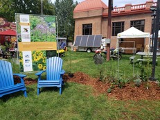
Lawns to Legumes Pilot Program
The Lawns to Legumes Pilot Program strives to increase pollinator habitat by providing Minnesotans with the tools they need to create habitat in their yards. Since fall 2019, the program has offered ecological gardening workshops, coaching, cost-share funding and planting resources to Minnesotans who want to incorporate pollinator-friendly native plants into their home landscaping.
|
The Minnesota Board of Water and Soil Resources (BWSR) administers the pilot program with assistance from Blue Thumb – Planting for Clean Water and Metro Blooms. Funding is provided by the Environment and Natural Resources Trust Fund.
Highlights/Outcomes:
|
|
|
 |
-
4.5 million total square feet of pollinator habitat created
-
3000 projects completed by Minnesota residents (plus many DIY projects)
-
26 Demonstration Neighborhoods established
-
18,000+ applications received for individual support grants
-
28 pollinator habitat workshops held - attended by 5,745 people
-
353,373 program website visits (BWSR and Blue Thumb web pages combined)
-
140+ volunteer coaches
Resources include:
-
BWSR's Planting for Pollinators Habitat Guide is an in-depth guide intended to help gardeners plan, implement, and maintain pollinator habitat projects.
- Pollinator Garden Templates: These templates provide base designs for native plant pollinator gardens, including boulevard and shade garden designs. They are customizable with substitutions for each plant.
- BWSR Ecological Gardening Blog posts:
Browse additional resources on the Lawns to Legumes webpage.
Don't "Clean Up" too early in the season

If you are planning to garden this spring, please note that many pollinators overwinter by taking shelter in dead plant material in your yard. For this reason, don’t rake or otherwise disturb dead leaves and other plant matter until temperatures consistently reach 50 degrees, or until you start seeing dandelions!
|
Note: This article is an update to the version in the March 2021 Water Talk
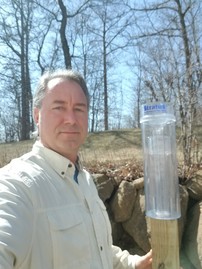
The State Climatology Office is looking for volunteer rainfall monitors for the Community Collaborative Rain, Hail and Snow Network (CoCoRaHS). The network includes more than 20,000 volunteers nationwide who measure precipitation in their backyards using a standard 4-inch-diameter rain gauge. State Climatologist Luigi Romolo said the data from backyard rain gauges are helpful and important in many ways.
“These volunteers help to verify high rain and snow totals after big events, monitor drought and flooding, make our precipitation maps more accurate and provide needed guidance on Minnesota’s changing climate,” Romolo said. “This is also a great educational activity for families with kids and a rewarding hobby for anyone interested in weather or climate.”
Volunteers are particularly needed outside the immediate Twin Cities metro area. Volunteers receive training on how to observe weather trends and how to submit their precipitation and weather event reports. All training material is available online. They must purchase or provide a standard 4-inch-diameter rain gauge (available at discount through CoCoRaHS) and have internet access to submit reports.
To sign up or for more information, visit CoCoRaHS.org or contact Luigi Romolo. The website includes lesson plans for STEM students and instructional videos for all participants.
|
By Ceil Strauss, DNR, State Floodplain Manager
See National Weather Service (NWS) forecast for flooding
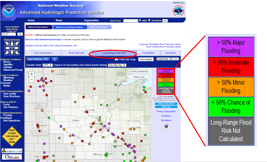
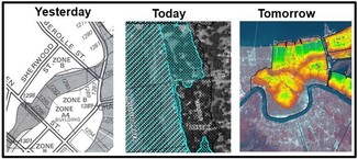
The map below is from the NWS Advanced Hydrologic Prediction Service (AHPS) site for central and south central Minnesota. (Select the "Long-Range Flood Risk" tab to see this view.) River gages with purple squares have a greater than 50 percent likelihood of major flooding.
Note that the Major, Moderate and Minor Flooding triggers are based on the damages and disruption seen at those river levels. Those triggers are not the same as the "100-year" or "500-year" flood elevations; major flooding can occur at elevations above or below the "100-year" flood elevations used for regulatory purposes.
 See more details for each gage
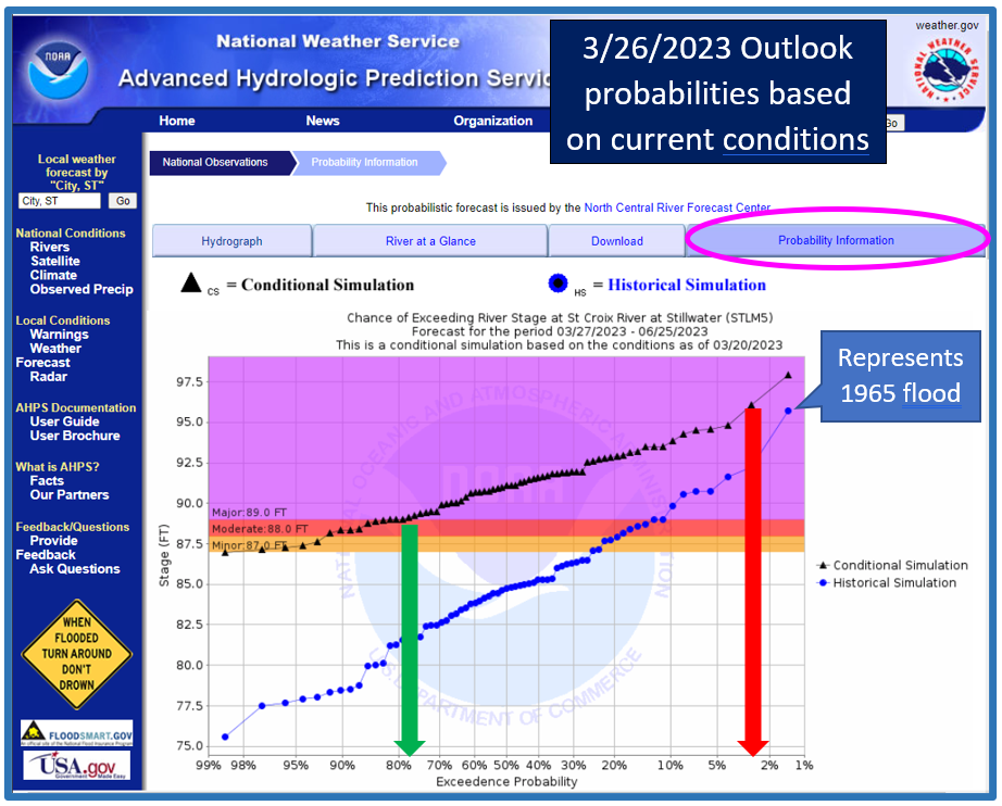
To see more detailed information, select a gage site. If you look at the "Probability information" tab, information like that shown below for the St. Croix River at Stillwater can be seen. The small blue circles on the graph show the historical peaks for many years of records. The black triangles show what the peak river levels could be depending on how fast spring melting occurs and how much precipitation occurs. If it melts quickly and we have heavy rain at the same time, the levels will be higher. The green arrow shows that - based on conditions as of March 26, 2023 - there is a >75% chance of major flooding in Stillwater between March 27 and June 25, 2023. The red arrow (further to the right) shows an approximately 3% chance of exceeding the 1965 flood of record.
 Note that in 2019 there were similar forecasts for high probability of spring flooding in many parts of Minnesota. While river levels stayed above flood stage for record lengths of time at many gages, a "perfect melt" of warm days and dropping below freezing at night prevented more major flooding and damage.
On the DNR's Flood Preparation, Response and Recover page, find links to more NWS gage sites and to the Cooperative Stream Gaging Program page with many more gage sites supported by the DNR and the Minnesota Pollution Control Agency (MPCA).
By Ceil Strauss, State Floodplain Manager
FEMA Mapped Floodplain and Adjacent Areas
Most local zoning officials realize their floodplain regulations require the lowest floor of new buildings, additions, and substantially improved/damaged buildings to meet the Regulatory Flood Protection Elevation (RFPE) defined in their ordinance. The minimum RFPE is the one percent (1%) annual chance flood elevation ("100-year" elevation) + one foot of freeboard (a safety factor) + "stage increase" of up to 0.5 feet.
Adjacent areas: Remember areas adjacent to FEMA mapped floodplains that are below the 1% annual chance floodplain are also subject to the community floodplain regulations. See page 39 in Minnesota's Floodplain Management Quick Guide for a helpful explanation of this requirement.
Outside the Floodplain, but Within Shoreland District
Once the local official determines the property is outside of the floodplain, they may think they are done. But that is not the case!
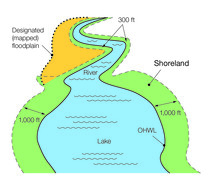
When a community has a Shoreland Management ordinance, those regulations apply within the entire shoreland district. The shoreland district includes:
- On lakes, the shoreland district extends 1000 feet from the Ordinary High Water Level (OHWL), and
- On watercourses, the shoreland district extends at least 300 feet from the OHWL, and extends to the landward edge of the floodplain if that is more than 300 feet from the OHWL.
|
What is the Minimum Elevation within Shoreland Districts?
Minnesota Rules (6120.3300, subp. 3, B.) - which have been in place for over 50 years - give direction on how to determine the lowest floor elevation. In general:
- If there is a flood study for the basin or watercourse, use the minimum elevation used in the floodplain, the RFPE.
- If there is NOT a flood study, take the OHW or the Highest Known Water Level - whichever is higher, and add three feet.
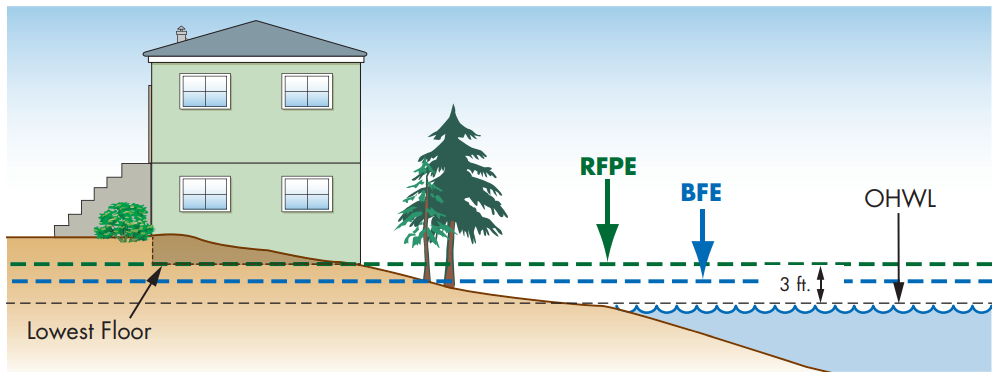 Figure from page 40 in 2022 Minnesota Floodplain Management Quick Guide (see link to guide in article below)
Questions about a specific site?
Contact your local zoning authority (your city if within city boundary, or county if within unincorporated areas). Note: Many local ordinances have higher standards than the state minimum requirements.
Local officials can reach out to DNR floodplain program staff or your DNR area hydrologist if you need help determining the required elevation.
Updated as of December 2022
The 2022 update of the Floodplain Management in Minnesota Quick Guide has arrived. If you liked the 2020 version, you'll like this this version even better!
The Quick Guide is filled with useful graphics and targeted at local officials and other professionals involved in floodplain management, as well as landowners.
|
How to get a copy
Additions Include:

- New section separator pages help with navigation
- Former page covering both Letters of Map Amendment (LOMAs and Letters of Map Revisions based on Fill (LOMR-Fs) separated into two pages; Letter of Map Revisions (LOMR) updates
|
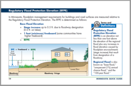
- Regulatory Flood Protection Elevation (RFPE) definition page moved earlier in guide (page 19) and showing more natural area next to flooding source
- New page on solar projects
|
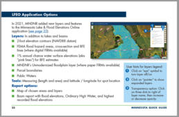
- Additional page about DNR's Lake & Flood Elevations Online (LFEO) noting 2021 new features
- General requirements for coastal high hazard zones (V Zones) was added for future coastal mapping on Lake Superior (see page 59)
- Updates due to changes in flood insurance rating (Risk Rating 2.0)
|
Visit the May 2020 Water Talk article on the 2020 Quick Guide for a summary of content in the original 2018 Quick Guide and added in the 2020 update.
By Ceil Strauss, DNR, State Floodplain Manager
Reducing flood risk is always important. But with the current wet conditions, and higher probability of flooding in the spring, there is heightened interest in actions we can take to reduce your risk.
Steps everyone can take
-
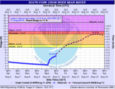
Monitor local water level conditions - Sign up for alerts from your community and the National Weather Service (NWS). Check the NWS river gage locations in Minnesota and select gages in your area to view current river levels, forecasts and outlooks. Note: Sample view of gage with observed and forecasted river levels (to right).
-
Consider purchasing flood insurance - Anyone in a community that participates in the National Flood Insurance Program (NFIP) can purchase flood insurance. Those with homes & businesses in the low and medium risk areas can purchase the discounted Preferred Risk Policy. Note: there is a 30-day waiting period for the policy to be effective. See more information at www.floodsmart.gov.
-
Build smart - Follow your community's floodplain, shoreland management and other local zoning requirements (including minimum elevations) for new construction, additions, or improvements of buildings, and any grading or other development.
|
Additional steps for communities:
-
Adopt or update local Emergency Action Plans. The U.S. Army Corps of Engineers has a Community Resources Toolbox with links to preparation guidelines and resources.
-
Action Plans to Reduce Damage (especially for those at greater risk) - Move belongings to higher levels. Save back-up records off-site. Consider needed flood fighting options such as pumps, sandbags, berms, or other protection in advance.
-
Determine flood response priorities - Where will detours and temporary dikes and sandbagging be needed? What critical facilities - i.e., utilities, nursing homes, hospitals, government response centers - are most at risk? When are evacuations triggered?
-
Think about long-term mitigation options - What projects are in your county's (or community's) latest All Hazard Plan? Learn more at the resource links below.
For more information:
On the DNR Floodplain Program site:
On the Minnesota Division of Homeland Security and Emergency Management site, learn more about hazard mitigation planning, the State Hazard Mitigation Plan, success stories, and FEMA grant programs.
Note: This is an update of an article in the December 2019 Water Talk
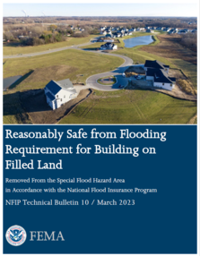
Recent update to previous 2001 version
Major Updates in TB 10 include:
- The title has been updated. It was previously Ensuring That Structures Built on Fill In or Near Special Flood Hazard Areas Are Reasonably Safe From Flooding in Accordance with the National Flood Insurance Program.
- The intent of TB 10, and when it is appropriate to use TB 10, has been clarified.
- Increased emphasis on documentation needed for a local official to make the “reasonably safe from flooding” determination.
- Additional best practices are provided.
- Grouped and reorganization of the content discussing the Technical Approaches to Seepage Analysis in Section 9.
Warning: Section 9 (for basements) not valid in most Minnesota communities
Section 9 of TB 10 discusses options for constructing a basement if several very specific steps are taken. The main requirements are that a LOMR-F is obtained for a lot or portion of a lot, then the "Simplified approach" or engineering approaches discussed in section 9 are used to construct a building with a basement.
In Minnesota, these basement options cannot be used for residential buildings unless the community is one of the handful of communities with a formal "Basement Exception" (all are in the Red River Valley), or the few communities that have adopted Technical Bulletin 10 and the options laid out in the bulletin, in the community's floodplain management ordinance. Contact DNR floodplain management staff if you have questions about your community's options.
FEMA Region 5 staff (based in Chicago, IL) are continuing their monthly one hour virtual training series in 2023. They are FREE!
It's not too late to register for many training topics!
Upcoming "Managing your Community's Floodplain" monthly series dates and topics:

Note: All held 9-10 am Central Time.
-
April 26, 2023: Development Permitting; Registration Link
-
May 31, 2023: NFIP Compliance; Registration Link
-
June 28, 2023: Insurance is Mitigation; Registration Link
These trainings and registration links are also available on DNR's Floodplain Training and Education page.
|

Talk with FEMA and DNR Floodplain program representatives during monthly virtual Minnesota Floodplain Management Office Hours. Hours are 10-11 am, typically on the fourth Thursday of the month (but a few are adjusted).
Upcoming monthly hours (Note: all are 10 - 11 am central time)
Where: Teams. No registration is required. Select a date to get the Teams meeting appointment.
These office hour dates and links are also available on DNR's Floodplain Training and Education page.
|
Important Dates to Note:
(since February 2023 Water Talk and upcoming in next couple months)
|
|
 |
Preliminary Maps
- Feb. 15, 2023 - Dodge Countywide
- Feb. 28, 2023 - Stevens (revised panels)
- March 8, 2023 - Wilkin (panels)
- May 2023 - Wabasha Countywide
Local Officials Meetings & Open Houses
- April 5, 2023 - Chippewa Countywide; Local Officials Meeting and 5-7 pm public Open House
- April 11, 2023 - Dodge Countywide; Local Officials Meeting and 5-7 pm public Open House
- April 12, 2023 - Stevens Countywide; Local Officials Meeting (one added community)
90-Day Appeal Periods
- Le Sueur County - Feb. 16 to May 17, 2023
- Pipestone County - April 20 to July 19, 2023 (anticipated)
Letters of Final Determination (LFDs)
- March 7, 2023 - Lincoln Countywide
- March 21, 2023 - Olmsted (Zumbro panels)
Effective (6 months after LFD date)
Additional Map Update Information:
|