|
Flooding has been occurring in much of the state this spring and summer. We gave some updates in our Spring 2022 Flooding Impacts Water Talk article. While documenting the extent of damage is still in progress, we have some updates to share.
Flooding at Northern Border
With high flood levels along much of the Northern Minnesota border with Canada, many roads were closed, making access to many locations a challenge. Major sandbagging efforts were seen in the border communities, especially in areas of historical resorts.
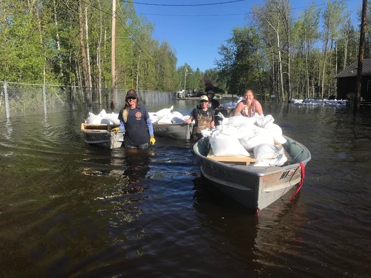 An example of both the flooded roads and sandbagging efforts. Photo provided by City of Ranier, MN
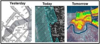
Record and near record lake levels
Water levels on Rainy Lake set a new record, passing the 1950 record peak. Lake of the Woods passed the 2014 peaks, and came close to the 1950 record peak.
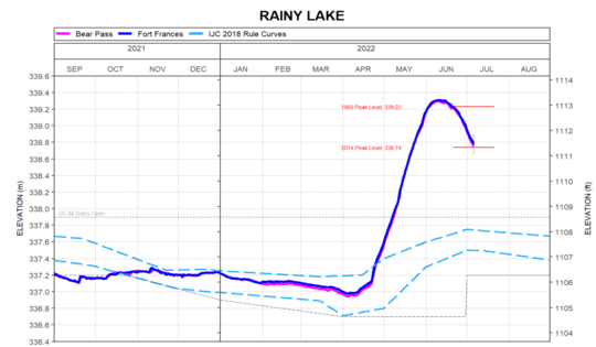 Rainy Lake water levels relative to past historical peaks. Source: Lake of the Woods Control Board.
See the Lake of the Woods Control Board site for more details, including lake water level graphs:
Preliminary Damage Assessments (PDAs) for Public Assistance (PA)
Local officials and the Department of Public Safety Division of Homeland Security and Emergency Management (DPS-HSEM) staff began Preliminary Damage Assessments (PDAs) of public infrastructure damage the week of May 23, 2022. The PDAs are part of the process to determine whether a state or Presidential disaster declaration is warranted. (See FEMA's site on the Public Assistance program.)
Governor Walz submitted two official requests for disaster assistance covering 38 counties and 4 tribal nations.
May 8-13, 2022 Flooding, Tornadoes & Severe Storms - A request for a federal declaration was made for: Aitkin, Benton, Big Stone, Cass, Chippewa, Cottonwood, Crow Wing, Douglas, Grant, Kandiyohi, Lac qui Parle, Lincoln, McLeod, Morrison, Murray, Nobles, Pope, Redwood, Renville, Stearns, Stevens, Swift, Todd, Traverse, Wadena, Wilkin and Yellow Medicine Counties.
April 22, 2022 & Continuing Flooding - A federal declaration request was made for: Boise Forte Band of Chippewa, Leech Lake Band of Ojibwe, Red Lake Nation and White Earth Nation, and Beltrami, Clearwater, Cook, Isanti, Kittson, Koochiching, Lake, Lake of the Woods, Mahnomen, Marshall, Norman, Pennington, Polk, Red Lake, Roseau, and St. Louis Counties.
Local officials can be overwhelmed when there is a large disaster, whether it's due to flooding, tornadoes or other extreme events. Having a local response plan and becoming familiar with resources before a disaster occurs will help all involved. Spring flooding may be the biggest concern in many communities, but flooding due to major rains in the range of 10 to 14 inches have occurred all around the state during spring, summer and well into the fall.
The DNR Floodplain Program recently posted the Minnesota Post-Disaster Substantial Damage Playbook for Local Officials, a useful resource to help local officials know their responsibilities post-disaster.
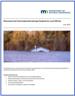
The playbook includes information on:
• Steps in Processing a Building Permit for Damaged Buildings
• Substantial Damage and Substantial Improvement Determinations
• Sample Handouts, Letters, and Press Releases
• Community Responsibilities
• Information on Mitigation Programs & Strategies
|
For more information on post-disaster preparation, local response plans, and related resources:
The Association of State Floodplain Managers (ASFPM) has released a tool to help build flood mitigation awareness in your community.
Footage of catastrophic flood waters washing away roads, houses, and bridges in Yellowstone National Park last month captured the public’s attention and no doubt left many wondering about their own flood risk and what they can do to reduce it.
As you work with property owners looking to make informed decisions around the actions they can take to lower their risk of flooding, ReduceFloodRisk.org can help. Developed by ASFPM with financial support from FEMA, this interactive website empowers people to protect themselves and their most valuable asset.
To get started, people can go to ReduceFloodRisk.org, answer a series of five simple questions, and receive a detailed list of mitigation options recommended to reduce flood risk for their specific property type. The curated results can be filtered and sorted by key attributes, such as cost, complexity, and level of required maintenance.
See a short introductory video demonstrating what you can see at the site.
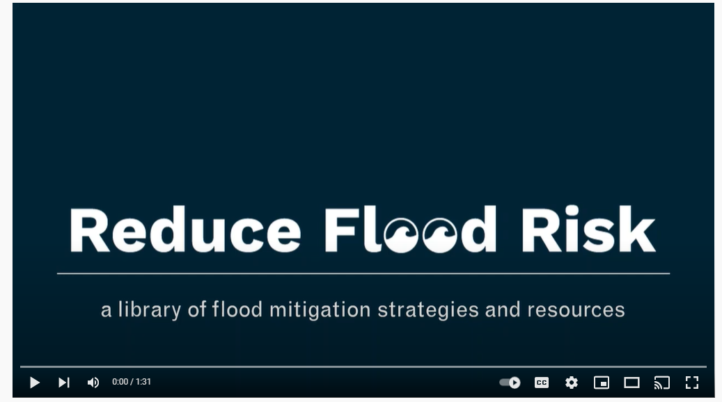 Introductory video on the Reduce Flood Risk site
In addition to its decision-support engine, ReduceFloodRisk.org features a variety of resources to help property owners and renters better understand flood risk, flood insurance, financial assistance options, and who to contact with any questions they have about flood mitigation. The site is completely free and users do not need to create an account to gain access to the resources.
Check out the Reduce Flood Risk site for yourself!
Note: This article adapted from an ASFPM notice.
Interested in joining the DNR Division of Ecological and Water Resources (EWR) team? The division is hiring a new Floodplain Management & Dam Safety Hydrologist position.
Go to the MN Careers site and enter "56973" to see the posting. This position will provide technical assistance, monitoring, training & educational resources to local governments and property owners statewide, coordinate on floodplain mapping and outreach efforts, and support dam owners with implementation of emergency action plans for high hazard dams. Closing date is July 19, 2022.
Or, What is Section 1206?
When disaster strikes, many communities have hundreds, if not thousands, of structures to protect against future damage or restore to local codes and standards. Section 1206 of the Disaster Recovery Reform Act (DRRA) authorizes the Federal Emergency Management Agency (FEMA) to reimburse communities that participate in the National Flood Insurance Program (NFIP) for the resources needed to effectively administer and enforce building codes and floodplain management regulations following a major disaster declaration. This creates new eligible activities through FEMA’s Public Assistance (PA) Program to carry out required post-disaster activities (e.g., substantial damage operations, permitting, etc.)—increasing the overall speed of recovery and enhancing NFIP compliance.
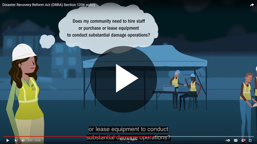
NEW: DRRA Section 1206 Video Published
FEMA developed this introductory video to DRRA 1206 to arm floodplain administrators, emergency managers, elected officials, and other stakeholders in the recovery process with the information needed for successful reimbursement of these new eligible activities. Through the Floodplain Administrator’s, “Maria,” story following a devastating disaster in her community, viewers will learn key eligibility requirements for communities, work and costs covered under the policy, and how to seek reimbursement for these new activities.
Watch the full video on the FEMA YouTube channel.
 Questions? Please reach to your FEMA Regional or State NFIP Coordinator's Office (Minnesota floodplain program contact).
Additional Resources: Visit FEMA.gov to view the full DRRA 1206 policy and read frequently asked questions.
Note: Adapted from a FEMA update.
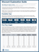
We've been highlighting updates in FEMA's new flood insurance rating system - Risk Rating 2.0 (RR 2.0) - which is effect for all new/renewing policies as of April 1, 2022.
Under the previous flood insurance rating system, properties shown in the Special Flood Hazard Area for the first time had 12 months to purchase a newly mapped policy that was effectively the same rate as a Preferred Risk Policy, the policy option for a building in the lower risk zones. The policy was then on a glide path to the full risk rate in subsequent annual renewals.
We still have Newly Mapped discounts! Under RR 2.0, Newly Mapped buildings get a 70 percent discount on the first $35,000 of building coverage and first $10,000 of contents coverage.
|
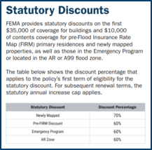
Pre-FIRM Discount:
Buildings constructed before the first Flood Insurance Rate Map (FIRM) for a community get a 60 percent discount on the first $35,000 of building coverage and first $10,000 of contents coverage.
Emergency Program Discount:
Under RR 2.0, policies in Emergency program communities get a 60 percent discount on the first $35,000 of building coverage and first $10,000 of contents coverage. Those coverage limits are also the limits for residential policies in the Emergency program.
Statutory Caps For Annual Increases
The policies that receive Newly Mapped, Pre-FIRM or Emergency program discounts will be on a glide path to the full risk rate for subsequent year renewals, with a statutory cap on the annual increase.
The statutory caps on annual rate increases are:
- 18 percent for primary residential buildings
- 25 percent for non-residential buildings and second homes.
|
For more information: Visit FEMA's Risk Rating 2.0: Equity in Action page

Many of you attended the series of one hour virtual trainings presented by DNR Floodplain Program, Shoreland/River Program and Climatology staff in early 2022. Those trainings were recorded (and captioned). The floodplain topics are now posted on the DNR's Land Use Program's Training and Education page. And you can see all 16 topics in the 2022 Winter Floodplain & Shoreland training series playlist. Whether you missed the trainings or want a refresher, they are available to all who are interested.
Warning - Updates in Progress: The Floodplain and Shoreland/Rivers programs Training and Education page will be going through big updates over the next few months. We'll be separating out pages for the Floodplain Program, Shoreland/River Program, Water Talk newsletter, and possibly other topics. Our intent is to improve the flow and usefulness of our site, and make it easier to find the resources you are seeking.
|
FEMA Region 5 staff (based in Chicago, IL) are continuing their monthly one hour virtual training series. They are FREE!
It's not too late to register for many training topics!
Upcoming "Managing your Community's Floodplain" monthly series dates and topics:

Note: All held 9-10 am Central Time.
-
Topic #7 July 27, 2022: Managing FIRM Map Changes and Community Acknowledgement; Registration Link
-
Topic #8 August 31, 2022: Coastal Resilience and Floodplain Management; Registration Link
-
Topic #9 September 28, 2022: Resolving Potential Violations; Registration Link
-
Topic #10 October 26, 2022: Higher Standards
-
Topic #11 November 30, 2022: Basement Flooding Mitigation
-
Topic #12 December 14, 2022: No Adverse Impact
|
Important Dates to Note:
(since May 2022 Water Talk and upcoming in next couple months)
|
|
 |
Preliminary Maps:
- July 2022: Dodge, Le Sueur, Morrison and St. Louis Counties
- August 2022: Pipestone and Rock Counties
- September 2022: Chippewa County
Local Officials Meetings & Open Houses
- Wright County - Local Official Meeting & Public Open House (for communities receiving revised preliminary maps 4/22/2022) - August 2, 2022
90-Day Appeal Periods
- Carlton County - 3/31 to 6/29/2022
- Watonwan County - 7/8 to 10/6/2022
Letters of Final Determination (LFDs)
Effective (6 months after LFD date)
- Lyon County (levee panels) - Sept. 15, 2022
- Nicollet County - Oct. 13, 2022
- Lake of the Woods County - Oct. 27, 2022
- Koochiching County - Nov. 17, 2022
- Pennington County - Dec. 1, 2022
Additional Map Update Information:
|
|
 |
|