|
Jan. 26, 2021

The Coastal Hazards of Superior (CHAOS) Winter Meeting is on January 27. Join us for a virtual meeting to learn more the Great Lakes Coastal Flood Study, using the Tribal Climate Adaptation Menu for hazard mitigation, and recent habitat restoration projects at Wisconsin Point.
|
The CHAOS Winter Meeting features:
-
Alan Lulloff, Association of State Floodplain Managers, will talk about FEMA’s Great Lakes Coastal Flood Study to update coastal flood maps. Alan will provide an overview of the mapping methodology including how it incorporates wave run-up and water levels and what these new flood maps will mean to coastal communities.
-
Angela Yu and Rachael Pressley, Western Upper Peninsula Planning & Development Region, will talk about hazard mitigation planning with the Keweenaw Bay Indian Community. Angela and Rachael will talk about using the Tribal Climate Adaptation Menu to incorporate climate and coastal hazards mitigation in their planning efforts.
-
Linda Cadotte, City of Superior, and Rob Peterson, WSP, will talk about recent restoration efforts on Wisconsin Point. Linda and Rob will speak about the innovative design of a marsh sill living shoreline project along Allouez Bay.
The CHAOS Community of Practice is a learning hub about coastal hazards that affect Minnesota and Wisconsin’s communities. Membership in the community is free and open to anyone with an interest learning and sharing about coastal hazards and resiliency. For more information, please reach out to Melanie Perello at Minnesota’s Lake Superior Coastal Program.
Register for the meeting: https://uwmadison.zoom.us/meeting/register/tJMldOupqT0rEtZAfuTRUso-mjMit2EENzcw
By Pat Lynch, DNR, State Flood Hazard Mitigation Grant Program Manager
After a regular and four special sessions of the 2020 Minnesota legislature, a record $1.9 billion capital improvement bill was overwhelmingly passed during the fifth special session on Oct. 15, and signed in to law by Governor Walz on Oct. 21, 2020.
Included in this massive bonding appropriation is $17 million to the Minnesota DNR for the state’s Flood Hazard Mitigation (FHM) Grant Assistance Program. The DNR’s bonding request was for $20 million. This longstanding pass-through grant program provides cost share funding to local units of government to design and implement a host of publicly-owned capital improvement projects to reduce flood risk. Local units of government eligible for funding consideration include counties, cities, townships, watershed districts, water management organizations, lake improvement districts, joint powers authorities and legally-formed local governments.
Need to prioritize projects
The $17 million 2020 FHM appropriation language names 21 local/community projects and 12 watershed districts. It includes a $2 million line item appropriation for a project in Brown’s Valley located in western Minnesota. Demand for funding always exceeds availability. Because the appropriation was less than requested, and because the needs of all of the projects listed in the bill far outweigh the $17 million available, difficult choices had to be made in the allocation of limited funding.
There is an application process through the DNR that prioritizes projects based upon flood risk and project readiness as well as criteria set forth in the program’s enabling legislation. High priorities include:
- Projects that have existing FHM grant funding and are in a state-funded phase of design or construction.
- Community-based projects providing flood risk reduction to large numbers of structures or public infrastructure in flood prone areas.
- Acquisition and removal of homes located in the floodplain.
- Projects that leverage other federal and local funds are of particular priority, as they stretch the state dollar.
Approved Projects
After careful consideration, prioritization and consultation with applicants, a plan to award the $17 million 2020 FHM state funds has been finalized. The 2020 grant funds will be allocated to the following projects*:
|
Sponsor
|
Project
|
Proposed 2020 Award
|
|
City of Afton
|
Levee reconstruction – final phase
|
$750,000
|
|
City of Browns Valley
|
Toelle Coulee drainage improvements
|
$2,000,000 (line item)
|
|
City of Breckenridge
|
Internal drainage
|
$1,500,000
|
|
City of Carver
|
Levee reconstruction- phase 1
|
$150,000
|
|
City of Faribault
|
Waste Water Treatment Plant protection
|
$2,500,000
|
|
City of Golden Valley
|
Flood storage (SEA School)
|
$1,300,000
|
|
City of Jordan
|
Community flood protection phase 1
|
$500,000
|
|
City of Montevideo
|
Federal project community flood protection
|
$2,500,000
|
|
City of Moorhead
|
Floodplain acquisition
|
$2,800,000
|
|
Cedar River Watershed District
|
Flood impoundments
|
$500,000
|
|
Roseau River Watershed District
|
Roseau Lake Flood Storage
|
$1,000,000
|
|
Red River Basin
|
Flood risk reduction in Red River Watershed
|
$1,500,000
|
*Final award amounts may vary from the information above as projects advance, bids are received, and cost estimates are refined
Typically a bonding bill is considered in even numbered years. It is anticipated that DNR’s 2022 bonding request will include additional FHM funding.
If you have any questions about the state’s Flood Hazard Mitigation Grant Assistance Program or any of the project funding, please contact Pat Lynch.
The Association of State Floodplain Managers (ASFPM) announced their annual conference will be virtual again in 2021.
ASFPM had great success with their virtual conference in 2020, and are planning an even better experience for the 2021 virtual conference. The full virtual program will be posted soon, and registration will open in February. Check the ASFPM conference website for updates!
|
Reminder: Scholarships available from MnAFPM for local officials to attend ASFPM conference
Scholarships are widely available for those who may need one. Budgets for training opportunities may be tight this year, but registration costs are not a reason to miss out!
For more information, including the scholarship application, please visit the MNAFPM website at www.mnafpm.org.
|
By Karl Koller, DNR, Clean Water Specialist
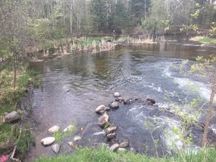
The pool below the road crossing on Clearwater Creek has been a favorite swimming hole for local residents. Parents sit in their camp chairs on the edge of the pool created by the water rushing through steep culverts as their kids cross the road to slide down the culverts like a waterslide.
|
In BEFORE photo to right: See the swimming pool formed downstream of the Clearwater River road crossing. The pool was "improved" for swimming with a small rock dam seen just downstream of the road crossing culverts, and a larger rock dam downstream (upper right in photo) that crosses the entire channel (and has a bigger impact). |
|
 |
Safety Hazard
But the location of this local swimming pool created a safety hazard for drivers and swimmers since it was at a dip in the road with reduced visibility.
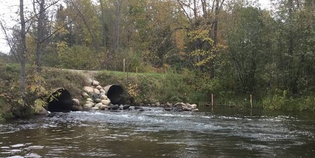 Before: Downstream end of Clearwater Creek road crossing. Rocks had been placed in this area in an effort to improve swimming conditions.
Road crossing also problem for fish passage
This Clearwater River road crossing was also recognized as an issue for fish. The high velocity water created by squeezing a 40 foot wide stream into two 5 foot culverts, and dropping at a three percent (3%) slope, created velocities that many fish could not navigate, especially during high spring flows, when fish have a limited time to reach critical spawning habitat.
This meant that many of the fish migrating up from the Prairie River system were denied access to several miles of stream leading to and connecting both the Wabana Chain of Lakes, and the Hanson Lakes Chain. Clearwater Creek is known to support a run of walleye, northern pike and white sucker, and many other species of fish and mussels have been observed, so replacing this crossing with one that was more fish-friendly has always been a priority for DNR Fisheries.
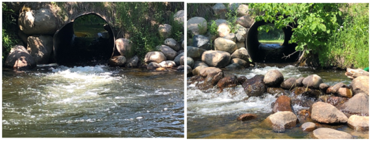 BEFORE: Looking upstream into the road crossing culverts. Note the "hydraulic jump" at the upstream end indicating high velocities. This fast water was a safety concern for swimmers and prevented fish passage.
So when the Itasca County Engineering Department approached DNR Ecological and Water Resources (EWR) Area Hydrologist Rian Reed, about replacing the culverts with a bridge, and requesting assistance with restoring the stream, the hydrologist and NE Region Clean Water staff immediately offered their technical help.
Project objectives
Early on in the process, ecological, social and safety objectives were defined:
- Design a crossing that would not inhibit aquatic organism passage, while maintaining or improving habitat, and would remain stable.
- Maintain current lake levels in Clearwater Lake. (The perched culverts and road crossing had raised lake levels for decades.)
- Maintain a swimmable area at the crossing. (Much of the land is private, so the goal wasn’t to promote swimming, simply not to eliminate it.)
- Maintain small boat landing upstream of crossing.
- Create a safer crossing. (Raising the road prism would improve driver’s visibility and allow swimmers to walk under a bridge instead of across a road.)
Getting data and local input
The hydrologist and Clean Water Specialists began to record water levels on the lake, to determine a lake elevation goal, and surveyed the stream channel. Staff worked with the county and consulting engineers on designing a crossing that would achieve the diverse objectives. Lakeshore landowners were contacted to hear any concerns and also help determine a lake elevation goal range. DNR Fisheries and EWR staff attended public informational meetings. DNR EWR staff oversaw and directed the entire channel construction.
The channel under the bridge was designed as a rock arch rapids. Large boulders were placed in a series of arch shapes directing flow towards the center of the channel, creating a series of steps and pools. Pools and random boulders provide resting areas for fish navigating the steeper slope. The need to maintain the public access at the upstream end meant that the rapids could not be lengthened to reduce its slope. In order to maintain lake levels within the target range, the elevation of the uppermost structure had to be modeled and construction had to focus on plugging the voids in the rock to minimize sub-surface flow.
 DURING PROJECT: Completed rock arch rapids prior to bridge construction. Large white bags at upper right were sandbags used to block stream and direct water into diversion culvert.
Balancing goals
In order to achieve some of the goals, it was determined that work on the stream would extend downstream of the crossing. Itasca County agreed to this even though it increased cost and required additional land-owner approval. The channel below the road was braided and very wide. If left that way, the pool likely wouldn’t maintain its depth and the reach would likely remain unstable. So narrowing of the channel below the crossing was part of the design which included construction of a rock riffle below the pool to both reduce the slope of the rapid, and improve habitat.
Some of the objectives appeared to be in conflict with each other. For example, the DNR prefers to stabilize the outsides of stream bends with "toe wood." Toe wood is a continuous structure along the bend in which large root wads, logs and smaller brush are placed along the base of the streambank, underwater, while the upper bank is constructed with sod mats or soil lifts. This approach creates a rough surface that dissipates the energy of the flowing water while creating cover for fish. But this didn’t appeal to swimmers. So the upstream third of the outside bend, where there is less stress on the bank, was lined with large boulder to allow swimming access. Installation of toe wood stopped short of the end of the bend to maintain access to a backwater area which provides habitat for amphibians, reptiles and small fish, and allowed a large cedar to be preserved.
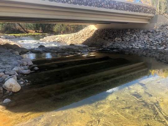 AFTER (Fall 2020): New bridge spanning Clearwater Creek. Stream channel components include: rock arch rapids constructed between bridge abutments and below public boat access. Outer bend a combination of large boulders and toe wood. Stream channel narrowed below bridge to a single channel, with part of side channel left in place and left connected on downstream end to provide access for fish. Riffle constructed at downstream end of project.
County and DNR partnership
Itasca County has been a leader in partnering with the DNR on ecologically friendly road crossings, being the first county to develop a General Permit for road crossings based on simulating the form of the stream to improve channel stability and aquatic organism passage. With over 60,000 road stream crossings in the state, this is an issue the DNR will be addressing for decades. And with projected climate change scenarios, there is more urgency for better sizing of culverts to reduce the risks of road failures.
In the end, the partnership between the county and the DNR, working with the consultants and willing contractors, created a crossing that appears to have achieved the diverse objectives set forth at the beginning. Hopefully it can serve as an example for others for what can be achieved when we think beyond just how to get vehicles across streams and partner on similar projects. And DNR staff will continue to monitor lake levels, the stability of the channel and observe fish usage.

Many readers may be familiar with the One Watershed, One Plan program administered by the Board of Water and Soil Resources (BWSR). The purpose of the program is to develop comprehensive watershed management plans for Minnesota's major watersheds. Watersheds that have an approved plan qualify for targeted Clean Water Fund support for priority projects. As of December 2020, there are 19 watersheds with approved plans and another 19 with planning projects under way (see map).
|
To help local stakeholders get a handle on watershed planning, BWSR recently produced a series of short videos, which altogether run about 35 minutes. They include:
- What is One Watershed, One Plan?
- Three Big Ideas
- Roles, Committees, and Commitments
- A Brief History of Watershed Management in Minnesota
- Making Choices to Show Results
See the 1W1P Videos
They are not just a great orientation to One Watershed, One Plan, but to watershed management generally. Check them out!

Great news! The Association of State Floodplain Mangers (ASFPM) advised members on Jan. 21, 2021 they had received confirmation that one of President Biden’s Executive Orders (EO) revoked Trump’s EO 13807, which revoked EO 13690 – the Federal Flood Risk Management Standard. Here is a link to the Jan. 20, 2021 EO on Protecting Public Health and the Environment and Restoring Science to Tackle the Climate Crisis.
The revocation of EO 13807 is in Section 7(b). The pertinent section of EO 13807 revoking EO 11988 is Section 6 (here is a link to the Federal Register on that one if you are interested).
Reinstatement of EO 13690 was an ASFPM Day 1 priority for the Administration, which had been communicated to the Biden-Harris Transition Team for FEMA.
What are EO 11988 and EO 13690?
EO 11988 was signed by President Carter in 1977. Federally funded projects have been required to meet the basic National Flood Insurance Program (NFIP) standards such as elevating the lowest floor above the base flood elevation (BFE), or the 100-year flood elevation. Federally funded critical facilities have been required to be outside of the 500-year floodplain.
There is also an eight step evaluation process to avoid, minimize and mitigate the project impacts.
President Obama signed Executive Order 13690 in January 2015 to amend Jimmy Carter's 1977 EO 11988. EO 13990 encourages the use of nature-based approaches in the project alternatives evaluation, and agencies can choose from different approaches in the Federal Flood Risk Management Standards (FFRMS). See more about the FFRMS and EO 13698 in the September 2016 Water Talk article "Changes Coming for Federally Funded Projects: FEMA Draft Rules Out for Federal Flood Risk Management Standards."
After EO 13807 was signed by President Trump, EO 11988 was back in effect.
For the latest updates on EO 13690, and the Federal Flood Risk Management Standard, see the Association of State Floodplain Managers (ASFPM) site.
Portion of this article adapted from ASFPM membership alert.
|
By David Mummert, FEMA eLOMA Coordinator
What is an eLOMA?
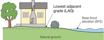
An eLOMA is a type of Letter of Map Amendment (LOMA). A LOMA is a letter from FEMA confirming that a portion of the map is incorrect based on more accurate elevation data, and the building is really in the lower risk Zone X. (See DNR's FEMA Map Appeals and Amendment page for more on LOMAs and other map appeal options.)
For example, the figure above shows a house that is eligible for a LOMA since the surveyed Lowest Adjacent Grade (LAG) is higher than the Base Flood Elevation (BFE). The normal LOMA process takes between 30 and 60 days.
|
eLOMA is an interactive online MT-1 determination tool, which is available on the Mapping Information Platform (MIP). This time saving, user-friendly web-based application provides licensed land surveyors and professional engineers (Licensed Professionals or LPs) with a system to submit LOMA requests to FEMA. This tool is designed to make a determination based on the information submitted by the LP and allow them to generate a determination from FEMA in a fraction of the time that is required for the standard LOMA process.
Eligible for eLOMA
Approximately 75% of the LOMA applications FEMA receives annually meet the eLOMA criteria and could be submitted using the eLOMA tool. An eLOMA determination document serves the same functions as a standard LOMA determination. The main purpose of eLOMA is to reduce the level of effort to process LOMAs and provide a faster method of generating LOMA determinations. The eLOMA process has significantly reduced the determination time of up to 60 days (standard LOMA processing) when an audit is not required. Even when an audit is required the audit is processed within five business days of FEMA receiving all of the required supporting data.
Updated eLOMA Process
The tool has been updated to make the eLOMA process even easier to use. The audit selection criteria have been revised so that fewer eLOMA submittals are selected to be audited. Also, more help links have been added to the eLOMA tool to provide more information about the requirements for the data entry fields.
Once an eLOMA LP has demonstrated that they have a comprehensive understanding of the eLOMA application process, they can be promoted to eLOMA "Super User" status. Typically, in order to be promoted to the Super User level an LP has to submit three consecutive eLOMAs that have complete supporting data and that require zero corrections, and they also need to use the eLOMA tool on a regular basis. Once an LP reaches the Super User level, their audit frequency is reduced dramatically. Super Users are not subjected to many of the automatic audit triggers as those submitting regular LOMA applications. Even when Super Users are audited, the turnaround time for those audits is typically shorter than it is for regular LOMA applications.
In order to begin using eLOMA, a surveyor or engineer sets up an account through the MIP using individual license certification information. Once the LP is registered on the MIP they can log into eLOMA and start submitting MT-1 applications. For more information on eLOMA, please select the "Learn about eLOMA" link in the upper left on the MIP homepage.
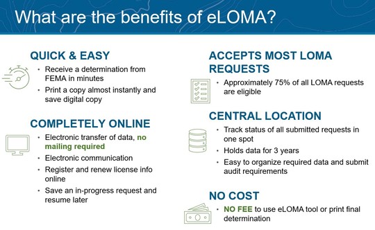 Additional information: If you have additional questions regarding the eLOMA tool, please contact the FEMA Mapping and Insurance eXchange (FMIX) at 1-877-336-2627 or FEMAMapSpecialist@riskmapcds.com.

Great news! The CRS Program has just released eight videos that cover training on the FEMA Elevation Certificate (EC). The videos describe each Section of the EC and explain which fields on the form are required for CRS purposes and why. Each video explains the most common errors we see on the forms and how to avoid them. We also have two videos covering general issues associated with ECs such as form date rules, page rules, how to handle annexations, how to handle Flood Insurance Rate Map (FIRM) changes after a building is permitted, and how to document different kinds of buildings. And lastly, we have a video on how to correct and EC once you find one with errors.
|
The videos should be watched beginning with Section A of the form, and ending with “How to Correct an Elevation Certificate.” They are intended to serve community officials, but please feel free to share these videos with the surveyors, engineers, and architects in your community who fill out these forms. They will benefit greatly from them as well.
The videos are:
- How To Fill Out Section A For CRS Purposes
- How to Fill Out Section B For CRS Purposes
- How to Fill Out Section C & D For CRS Purposes
- How to Fill Out Section E & F For CRS Purposes
- How to Fill Out Section G For CRS Purposes
- General Issues, Part 1
- General Issues, Part 2
- How To Correct an EC
From December 2020/January 2021 NFIP/CRS Update newsletter.
Stream Crossing Training
DNR Ecological and Water Resources (EWR) in the NE Region is considering offering online stream crossing training in March 2021. Potential topics include:
- An introduction to basic stream geomorphic processes and the stream simulation crossing design approach called "MESBOAC."
- Public Waters Work Rule requirements for bridge and culvert crossings and discussion on basic field survey data necessary to assess crossing design.
What's MESBOAC?
MESBOAC is a protocol for stream crossing designs which maintains channel and road stability and facilitates aquatic organism passage by simulating channel form. It is the basis for many of the DNR General Permits for bridge and culvert crossings.
Eligible audience
The intended audience includes individuals or organizations that routinely design, install or review stream crossings in the NE Region of the state, including:
- Road authorities, including engineers and surveyors,
- SWCD employees,
- and other DNR staff (including: Fisheries, Trails, Forestry, EWR, etc.).
You are eligible to attend if you work in the counties of: Aitkin, Cass, Carlton, Cook, Crow Wing, Itasca, Koochiching, Lake, Pine or St. Louis.
Timing / Registration
- This is expected to be a half day to full day of training online.
- Date TBD
To express interest, please contact Dani McNeil. You will be sent more information as date and time are determined. If you are responding on behalf of an organization / agency, please indicate the approximate number of employees interested in attending, and a point of contact for future updates.
Possibly Culvert Inventory App Training
Training in conducting a DNR culvert inventory, and use of the Mobile Collector App, is also being considered for the NE DNR Region this spring. (The NE region includes the counties of: Aitkin, Cass, Carlton, Cook, Crow Wing, Itasca, Koochiching, Lake, Pine or St. Louis.)
If interested, please contact Ben Nicklay.
Past, scheduled, and anticipated dates since November 2020 Water Talk:
Preliminary Maps
- Itasca County - 11/20/2020
- March 2021: Le Sueur, Morrison and Winona Counties (anticipated)
- April/May 2021: Dodge, Wabasha and Carlton Counties (anticipated)
Local Officials Meetings & Open Houses*
- Blue Earth County (revised prelim panels): Local Official Meeting - 1/5/2021
- Carlton County (St. Louis River watershed portion): Local Officials Flood Risk Review Meeting - 2/22/2021; 2 pm (with St. Louis County)
- Chippewa County: Flood Risk Review Meeting for Local Officials - 12/17/2020
- Koochiching County: Open House - March 2021
- Olmsted County (panels): Open House - 2/23/2021; 2-4 pm
- Lake of the Woods County: Open House - 2/18/2021; 4-6 pm
- Lyon County (panels with changed levee designations in Minneota and Marshall): Local Official Meeting - 1/7/2021
- Murray County: Kick-off Meeting - 2/23/2021; 10:30 am
- Pennington County: Open House - 12/2/2020
- Pope County: Local Official Meeting - Open House - 1/6/2021
- St. Louis County (countywide for riverine flooding, and St. Louis River watershed): Local Officials Flood Risk Review Meeting - 2/22/2021; 2 pm
- Waseca County: Flood Risk Review Meeting for Local Officials - March 2021
- Watonwan County: Open House - 2/23/2021; 5-7 pm
- Twin Cities Mississippi River HUC8 (portions of Anoka, Carver, Dakota, Hennepin, Ramsey, and Washington Counties) - Local Official Flood Risk Review Meetings:
- Bassett Creek Water Management Commission (WMC) - 2/24/2021 pm
- Ramsey Washington Watershed District (WD) - 3/4/2021 am
- Rice Creek WD - 3/11/2021 am
- Minnehaha Creek WD - 3/11/2021 pm
- Elm Creek WD - 3/18/2021 pm
- Coon Creek WD - 3/25/2021 am
- Shingle Creek WD - 4/1/21 am
- West Mississippi WD - 4/22/2021 am
*All meetings and open houses expected to be virtual until further notice.
90-Day Appeal Periods
- Pennington County - Dec. 9, 2020 to March 9, 2021
Letters of Final Determination (LFDs)
- Cottonwood County - March 24, 2021
- Yellow Medicine County - April 7, 2021
Effective (6 months after LFD date)
- Scott County - Feb. 12, 2021
- Red Lake County - March 9, 2021
- Marshall County - March 23, 2021
Additional Map Update Information:
|
