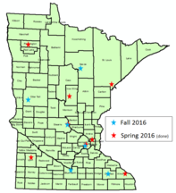
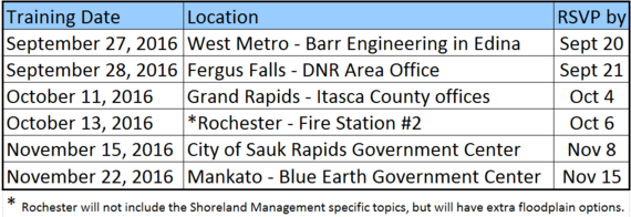
(This is a repeat of the article that was in the June 2016 Water Talk, except that the Rochester date has been set.)
Time:Registration
at 8:30. Sessions run from 8:45 am to 4 pm with an hour break for
lunch. Two tracks will be offered for most of the day so those attending
can choose to cover basics or more advanced topics.
Cost:
FREE for training. At most locations there will be an opportunity to
order (and pay for) box lunches that morning; bring cash or a bag
lunch.
Target Audience:
City, county and watershed staff who administer shoreland ordinances,
floodplain ordinances, interpret FEMA flood maps, or determine flood
elevations; or consultants, surveyors, insurance agents, realtors, or
others who work with these issues. Feel free to forward to others who
do work in mapped floodplain areas.
If you are interested in this training, please RSVP by the date listed for the location you will be attending.Contact Matt Bauman atmatthew.bauman@state.mn.usor
651-259-5710. Late registrations or walk-ins are welcome, but knowing
the number of participants by the RSVP date will help us prepare.
Topics Covered:
History of floodplain management regulations, roles, definitions, & permitted uses in floodway vs flood fringe
Registration for the 2016 MNAFPM conference will open
on September, 15. The conference will be held at the Best
Western Plus, Kelly Inn in St. Cloud, MN on November 16-18, 2016. The
MnAFPM annual conference attendees consist of federal, state and local
government officials, planners, engineers, consultants, researchers, educators,
watershed organizations, realtors, appraisers, and insurance agents.
The
conference agenda will focus on hydrologic and hydraulic modeling, recovery
programs, flood control projects, stream restorations, case studies and
mapping. The conference will include an all-day National Floodplain Basics
Review and the Certified Floodplain Manager (CFM) exam as well as training
sessions and a field tour. The conference will also include vendor exhibits and
networking opportunities.
Please register
online between September 15th and October 31st to get the
early bird discount and book
your hotel room early to get the discounted group rate.
As part of the Minnesota Association of Floodplain Managers conference November 16-17, 2016 in St. Cloud, Minnesota, the Association of State Floodplain Managers (ASFPM) Certified Floodplain Managers (CFM®) Exam will be offered at the conference site on November 18, 2016.
In order to take the CFM exam, you must complete and submit the CFM Program Application Package to the ASFPM. The forms are available on the ASFPM website www.floods.org under the Certification Program tab. The fee for taking the exam is $100 for ASFPM members and $450 for non-members. You may submit an application for ASFPM membership at the same time as applying to take the CFM® exam.
In order to be accepted to take the Certified Floodplain Managers Exam at the conference, you must submit your completed application along with the appropriate fee to ASFPM by November 4, 2016.
No walk-ins will be allowed unless authorized by the ASFPM Executive office.
People are often surprised when they discover that new
campgrounds are not allowed in flood-prone areas. In fact, it had only recently
come to the attention of our own floodplain program staff that Minnesota Department of
Health prohibits it, as outlined in Minnesota Rules, Section 4630:
4630.0200
LOCATION.
No
mobile home park or recreational camping area shall be so located that
drainage from the park or camp area will endanger any water supply. All such
parks and camps shall be well drained and no portion of the park or camp shall
be located in an area subject to flooding…
Most floodplain overlay districts only regulate the areas
within the FEMA mapped 1% annual chance floodplain ("100-year floodplain"), but the "area subject to flooding" language implies that campgrounds
are prohibited in all areas subject to flooding – mapped and unmapped. It would
be up to each community to best interpret where this would apply in areas outside of FEMA mapped high flood
zones.
The draw to establish a campground in such areas is
understandable given their proximity to water, recreational resources, and the
availability of space. Most of us have likely encountered such a campground
currently located in a floodplain. They are very common. All of these should be
treated as nonconforming uses, which would also limit their expansion.
If you do have a location you were hoping to develop as a
campground, maybe there are areas that can accommodate campsites outside of the
floodplain. Anyone that’s had a spoiled camping trip certainly knows that
camping near water has its advantages
over camping IN water!
2017 National Flood Insurance Program (NFIP) Reform?
The 2012 Biggert-Waters Act extended the NFIP five years - to September 2017. At a minimum, the NFIP needs to be extended before that expiration date. Landowners with buildings in the Special Flood Hazard Area (SFHA) - i.e., the "100-year floodplain - are mandated to purchase flood insurance if they have a federally backed mortgage (or secured loan). When the NFIP expires, new and renewed flood insurance policies cannot be purchased. All agree - including national realtor and home builder organizations - the NFIP should not be allowed to expire.
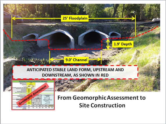
What: The graphic (above) demonstrates one of the first of an
ongoing MnDNR Division of Ecological and Water Resources initiative to promote application of land form measurements into
site design of infrastructure.
Where: Located in the new Whitewater State Park
campground, the final engineered design utilized information from a Geomorphic
Site Assessment to improve the site design.
Citizens recognize that it doesn't make sense to use federal money to rebuild buildings and infrastructure in places where we know that building or culvert crossing will be destroyed again in the next flood. If we need to build or rebuild in the high risk flood areas, we want to see it built in a way that is resilient and not vulnerable to repeated damage. This will save future taxpayer money, but even more importantly, it can prevent deaths and the costs associated with damage to homes and businesses.
The public and our elected officials increasing recognize that the requirement to build above the current mapped "100-year" elevations isn't enough. We need to recognize that more development leads to greater flooding risk, and that ongoing changes in climate are or will increase flood risks in many areas of the country.
What Are the Current Standards?
E.O. 11988 was signed by President Carter in 1977. Federally funded projects have been required to meet the basic National Flood Insurance Program (NFIP) standards such as elevating the lowest floor above the base flood elevation (BFE), or the 100-year flood elevation. Federally funded critical facilities have been required to be outside of the 500-year floodplain.
There is also an eight step evaluation process to avoid, minimize and mitigate the project impacts..
What Standards Are Proposed?
President Obama signed Executive Order 13690 in January 2015. E.O. 13690 amended the 1977 E.O. 11988 that is currently being used for federally funded projects.
Key changes in E.O. 13690 include:
- Encourages use of nature-based approaches in alternative evaluation
- Agencies can choose from the following Federal Flood Risk Management Standards (FFRMS) approaches:
Climate-Informed Science Approach (CISA): Utilizing the best-available, actionable hydrologic and hydraulic data and methods that integrate current and future changes in flooding based on climate science;
Freeboard Value Approach (FVA): Freeboard (base flood elevation + X, where X is 3 feet for critical actions and 2 feet for other actions);
0.2 percent annual chance Flood Approach (0.2PFA): 0.2 percent annual chance flood (also known as the 500-year flood); or
the elevation and flood hazard area that result from using any other method identified in an update to the FFRMS
- The CISA is noted as the preferred approach when data to support the analysis are available
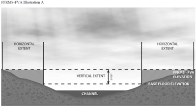
- When using the freeboard approach, E.O. 13690 calls for a horizontal
extension. This involves adding the 2 feet (or 3 feet for critical actions) to the Base Flood Elevation (BFE) and redraw the boundary of the FVA area based on that 2 foot (or 3 foot) higher elevation. If the federally funded project is in that expanded area, the project must be designed for the BFE + 2' elevation. The figure above (from the FEMA proposed rules document) shows an example of how far the regulated area could be extended in a flatter area.
How Will The FFRMS Affect My Community?
The types of projects subject to E.O. 13690 and the Federal Flood Risk Management Standards (FFRMS) are not expected to change, and the new standards will apply to the projects that start (or start the planning process) after the date the final rules become effective. The FFRMS will apply to projects being constructed - at least in part - with federal funds.
Each agency will give more detailed guidance, but in the proposed FEMA rules they note that construction or reconstruction projects funded under:
Public Assistance program (post disaster assistance for public buildings & infrastructure)
Hazard Mitigation Grant Program (HMGP) - grants available after a federal disaster declaration that can be used statewide
Flood Mitigation Assistance Program (FMA) - nationally competitive grants
NOTE: In Minnesota, the priority for use of the HMGP federal grant funds has been for acquisition of higher risk flood prone properties by willing sellers. Elevation projects - which would be subject to these standards - have been rare.
"Critical Actions" include constructing or repairing buildings like hospitals & nursing homes, emergency operation centers, generating plants, etc.
Each federal agency will do rule making or policy changes for their programs. For many communities, another important federal funding source is HUD, and they are expected to release proposed rules to address the FFRMS soon.
For More on FEMA's Proposed FFRMS Rules That Are Out For Review and Comment
The FEMA web page on the Federal
Flood Risk Management Standard (FFRMS) has background on E.O 13690 and the
draft implementing guidelines for the federal agencies. They also include fact
sheets prepared by the U.S. Army Corps of Engineers and Housing and Urban Development
(HUD) in response to frequently asked questions they have received in response
to E.O. 13690.
Further down that FEMA page is a link titled “Open Comment
Period Until 10/21/2016: FEMA's Notice of Proposed Rulemaking for to amend
regulations and implementing Executive Order 13690 for Floodplain Management
and Protection of Wetlands.” This section includes instructions on how to
comment and access to additional background.
Through Hazard Mitigation Assistance (HMA), FEMA provides an
average of $700 million annually in hazard mitigation grants, and now these
grants can be used for a variety of climate resilient mitigation activities. In September 2015, FEMA added three new grant
categories to the HMA portfolio and these changes were described as the Climate
Resilient Mitigation Activities (CRMA) initiative.The three CRMA project types are Floodplain
and Stream Restoration, Flood Diversion and Storage, and Aquifer Storage and
Recovery.
FEMA’s grants are provided through its Hazard Mitigation
Grant Program (HMGP), Flood Mitigation Assistance (FMA) and Pre-Disaster
Mitigation (PDM) grants and the new grant eligible categories address issues of
climate adaptation, resilience, and mitigation. These new
climate resilient activities are
consistent with a series of plans and Presidential directives including
Executive
Order 13653, Preparing the United States
for the Impacts of Climate Change; the President’s 2013 Climate Action
Plan; FEMA’s Climate Change Adaption Policy; and FEMA’s 2014-2018
Strategic Plan.
CRMA projects are not the typical project FEMA supports
after a disaster, such as buying out homes, building flood control structures, and
improving flood water conveyance. The
goal of a CMRA project is often the restoration of natural systems, protection
of the environment, and the reduction of risk associated with significant
changes in local climate conditions. CRMA
projects, through their focus on green infrastructure, reducing impacts to the
ecosystem, and climate adaptation, provide a community with viable alternatives
to simply building more pipes, more pumps, and more treatment facilities.Indeed, in some cases, CRMA-like projects
serve to undo the damage caused by well-meaning, but poorly planned “solutions”
such as straightening and channelizing streams and building flood control
features that adversely affect downstream communities.
The new grant categories address a series of issues that
have been highlighted in state and local plans related to changing weather
conditions and changing risks patterns. The
new grant categories include:
Floodplain and Stream
Restoration (FSR) projects include re-establishing the function of ecosystems
and floodplains as close to their original state as possible. The objective of the floodplain and stream
restoration projects is restoring the hydrologic and biologic functions of
environmentally sensitive properties Typically
these projects restore flood storage capacity of lands adjacent to rivers and
streams and they often restore the biological function of wetlands to filter
pollutants out of storm and flood waters.
As the name implies, Flood
Diversion and Storage (FDS) projects involve diverting floodwaters into
above-ground storage areas where the excess water will cause minimal impact to
residents, property, and infrastructure. The key to FDS projects is green
infrastructure methods—such improvements as rain gardens, bio swales, and areas
for flood water retention or detention. However,
the goal is not simply temporary water storage for the sake of keeping it out
of homes and businesses during a flood, but rather FDS projects seek to take a
long view and “re-use” that extra water for tomorrow’s needs by allowing it to
slowly seep back into the ground.
Finally, Aquifer
Storage and Recovery (ASR), involves the capture and storage of excess
water in an underground aquifer. The
storage of water underground eliminates many of the problems and dangers
associated with surface water storage. In
areas of the dry and arid Southwest, the protection and restoration of natural
aquifers and aquifer recharge areas are often a critical issue in community
development and resilience.Holding the
water underground protects this valuable resource from evaporation, most
pollutants, and extreme weather. Furthermore,
as the water is below the ground, there is generally less infrastructure to build
and maintain, and there is no worry of the flooding that can occur in the event
of a catastrophic dam or levee failure.
CRMA proposals may be considered under the HMA program for
those projects that are a result of a major disaster declared on or after
September 30, 2015, and for competitive Pre Disaster Mitigation and Flood
Mitigation Assistance funding for which the application period opened on or
after September 30, 2015.
Like other HMA projects, CRMA proposals must demonstrate
that they reduce risk and are cost effective.Fortunately, FEMA has developed a Benefit-Cost Analysis tool to be used
in the development and implementation of CRMA projects.Additional information on the BCA tools may
be found on FEMA’s website at https://www.fema.gov/media-library/assets/documents/110202.
In the long term, these grant categories reflect new
priorities for FEMA’s mitigation grants and they should be discussed at mitigation
planning meetings, public Risk MAP actions, and during other mitigation-related
activities. In addition, CRMA projects
and others like them should be incorporated into new and revised state and
local hazard mitigation plans.
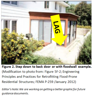
At step down to back door or within floodwall example - The lowest adjacent grade (LAG) would be taken on the landing or patio adjacent to the structure.
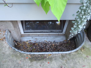
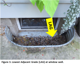
Answer: At window well example
The Lowest Adjacent Grade (LAG) is taken at the base of the window well. It is NOT taken at the "lip" of the window well.
WHAT IF HIGHER INTERVENING GROUND?
If the applicant could provide
elevations around the perimeter of the window well or stairs to demonstrate
intervening high ground (assuming that no fill was placed) FEMA will accept
that elevation.Here is an excerpt from
the FEMA MT-1 procedures:
Can the intervening high ground consideration be used in
cases involving loading docks and window wells?
The LAG must be taken at the bottom of the loading dock or
window well.However, we may use the
intervening high ground consideration only if the request is based on natural
ground, no fill, and the requestor has provided adequate topography to
demonstrate that there is sufficient high ground preventing flood waters from
reaching the lowest point of the structure (window well or loading dock).The LAG should be included in the determination
and the intervening high ground additional consideration paragraph should be
used.
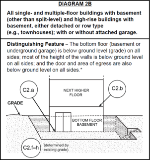
ON A RELATED NOTE:
FEMA's 2015 Elevation Certificate added Diagram 2B since this question has
become more common. Diagram 2B is used for the sunken patios - as shown
in the diagram - seen in some of the bigger cities. It is also used
for when there is just the door / landing area common in many parts of
the U.S., including Minnesota.