Twenty years after the flood – Reclaiming the Dead River watercourse
By JOHN PEPIN
Deputy public information officer
Michigan Department of Natural Resources
At about 5 p.m. May 14, 2003, an earthen dam burst on the Silver Lake Basin at the head of the Dead River, setting loose an estimated 9 billion gallons of water.
A flash flood warning would be issued and by 1:30 a.m. The chairman of the Marquette County Board of Commissioners would soon declare an emergency.
In the hours ahead, 1,872 residents would be evacuated from parts of Marquette closest to the river, while the waters that gushed down the 40-mile watercourse damaged or destroyed bridges and dams.
Homes and camps were damaged along the rim of the Dead River Basin, the Presque Isle Power Plant was flooded by the water and was forced to shut down, and parks and public boating access sites were also affected.
The problem had begun days earlier, when heavy rains and melting snow produced high-water spring runoff. The weekend before, temperatures soared to 80 degrees, hastening snowmelt. Heavy rains fell on May 11.
The combination of snowmelt equivalent to 7 inches of water in the upper watershed, followed by 5 inches of rain, filled the Silver Lake Basin.
In 2002, a “fuse plug” was installed at the dam at Silver Lake.
According to the U.S. Bureau of Reclamation: “A fuse plug embankment is an earth-fill structure designed to wash out in a predictable and controlled manner when the water surface of the reservoir behind it reaches a specified level.
“The purpose of a fuse plug is to provide a safe, economical means for controlling the maximum reservoir water surface elevation by increasing discharge capabilities during major flood events.”
|
The Dead River Flood originated at the fuse plug.
According to a post-event environmental assessment contracted for the Upper Peninsula Power Co. on the incident: “On May 14, 2003, a breach of the fuse plug occurred on the Silver Lake Basin, located on the Dead River in the Upper Peninsula of Michigan.
“In the area of the fuse plug, the force of the water created a new outlet stream channel, connecting to the original channel approximately 4,100 feet downstream of the former lake outlet. The released water caused erosion of the fuse plug, fuse plug foundation material, and spillway channel. In addition, erosion and deposition of eroded sediments occurred in selected downstream areas in the Dead River system.”
The river drains a watershed of about 163 square miles. The series of dams situated southeast of Silver Lake are used to help generate hydroelectric power before the river dumps into Lake Superior near Presque Isle.
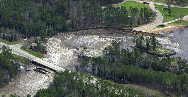
The Hoist, McClure and Forestville dams, which follow in that order in the downstream direction, were damaged as they were topped by the rising surge of floodwaters that raced downstream. The Tourist Park Dam, located the farthest distance from Silver Lake, was breached.
Debris from the dam and the water rushing down gradient pushed a large, brown plume of dirt, trees, garbage and other items into Lake Superior. The incident caused tremendous damage to the whole character of the stream.
“The cascading flood severely eroded the bank channels of an uppermost section of the Dead River, with collapsed channel walls and eroded sediment deposition, turning this section of the river into an entirely devastated ecosystem,” said George Madison, a Michigan Department of Natural Resources fisheries biologist at Baraga.
|
An initial assessment by the Federal Energy Regulatory Authority stated costs totaled $10.4 million for utility facilities damaged or destroyed, $84 million in community economic impact, $4 million for Dead River damage, including fisheries, soils and trees; $3 million for roads or bridges damaged or destroyed and $127,000 for emergency and public safety.
Restoration and recovery
What has followed in the two decades since the devastating Dead River flood has been a concerted effort to restore the river course in the upper reaches near the Silver Lake Dam and to direct compensation for damages toward worthwhile projects benefitting natural resources and public outdoor recreation.
Management’s priority following the flood was to restore public infrastructure and safety.
The then-Michigan Department of Environmental Quality (now the Michigan Department of Environment, Great Lakes, and Energy) headed up the process of deciding how to evaluate the environmental impacts of the flood and the actions necessary to recover the natural functions of the river and the valley of the watershed.
“Many agencies and groups were involved in the stabilization and recovery efforts,” Madison said. “Work commenced to stabilize raw-soil areas, reshape sediment deposits, rebuild the river channel and plant riverbank trees, shrubs and grasses.”
One of the landmark projects of the restoration efforts was the rebuilding of the Dead River channel from the Silver Lake Basin downstream to Marquette County Road AAO.
An engineering process called “natural channel design” was used.
“Work was also implemented to remove watershed erosion soils and materials that were deposited in the upper section of the river valley,” said Mitch Koetje, of EGLE’s Water Resources Division in Marquette.
|
Within the project area, the river was directed in serpentine fashion with large boulders put in the river at certain places to create rapids, pools and habitat for fish. Floodwater catching and recharging wetlands were also constructed along the river to help capture and hold flood water from the river, during natural flows and large flood events in the future.
Settlement
“Once the watershed was stabilized and natural flow conditions were restored, compensation was sought to mitigate for the loss of aquatic habitats and the loss of public use of the watershed resulting from the flood,” Madison said.
Terms of a consent judgment filed in Marquette County Circuit Court in June 2009 detailed compensation the Upper Peninsula Power Co. was to pay for Dead River flood damages.
“For several years leading up to the consent judgment, UPPCO was a willing and active partner in the environmental recovery effort,” Koetje said. “In fact, the utility made many of the necessary environmental improvements ahead of the court settlement.”
Prior to the announcement, UPPCO had spent more than $18 million on extensive recovery activities, including rebuilding the dam on Silver Lake.
“As part of the Dead River Mitigation Fund, the Michigan DNR’s Fisheries Division and EGLE’s Water Resources Division implemented projects in the western Upper Peninsula to utilize monies to develop cold-water fisheries, develop sustainable fisheries habitat projects, fund research and provide projects as compensation loss for recreational use,” Madison said.
|
Michigan DNR and DEQ/EGLE representatives provided oversight for implementation of mutually agreeable projects, including:
- The acquisition of land at boating access sites in Marquette County for developments on Lake Angeline and the Silver Lake Basin.
- The acquisition of Rocking Chair Falls.
- Bluegill stocking at Silver Lake Basin and bluegill, yellow perch and smallmouth bass stocking at the rebuilt Tourist Park impoundment to create panfish fishing opportunities in the Dead River.
- Coaster brook trout habitat restoration at the Salmon Trout River.
- Research on freshwater mussels and Great Lakes brook trout.
Specifically, UPPCO agreed to fund $575,700 in various mitigation activities conducted by the DNR or DEQ, including fish stocking activities in Silver Lake and the western Upper Peninsula, development of a replacement cold-water fishery, freshwater mussel monitoring and research and fish tissue monitoring in Silver Lake.
The utility also agreed to reimburse the state for $325,000 in enforcement costs and to pay for future oversight of remaining recovery and mitigation activities. A separate agreement with the Marquette Board of Light and Power led to additional recovery activities at Tourist Park.
Today and tomorrow
All environmental signs indicate that the watershed is recovering toward becoming a self-sustaining intact environment. Signs of moose, deer, beaver and small furbearers show that a full animal community is recolonizing the watershed and river valley. Signs of northern pike, smallmouth bass and panfish indicate that the Silver Lake Basin fish community is becoming restored.
“The watershed and the fish and wildlife of the system will continue to be monitored to ensure for full recovery of the Dead River impoundments, river corridors and recreational opportunities,” Madison said. “This watershed is a unique system as there is very little human development within much of the landscape.
“These types of remote landscapes are becoming less common in Michigan and the restoration of this system will provide for a special-place resource for the public to enjoy.”
|
Check out previous Showcasing the DNR stories in our archive at Michigan.gov/DNRStories. To subscribe to upcoming Showcasing articles, sign up for free email delivery at Michigan.gov/DNREmail.
Note to editors: Contact: John Pepin, Showcasing the DNR series editor, 906-226-1352. Accompanying photos and a text-only version of this story are available below for download. Caption information follows. Credit Michigan Department of Natural Resources, unless otherwise noted.
Text-only version of this story.
Course: An image shows the changes in watercourse direction after the Dead River flood.
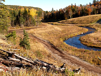
Dead River: An autumn view shows the recovering watercourse of the Dead River, downstream from the Silver Lake Basin.
Dead River Flood: An aerial photo shows the Dead River flood as the dam at Tourist Park was breached, sending rushing water toward Marquette County Road 550 and Lake Superior.
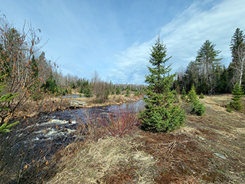
Nineteen: A photo shows the reconstructed Dead River watercourse in 2022.
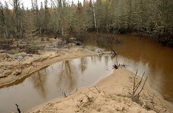
Post Flood: An image shows a damaged landscape along the Dead River in Marquette County.
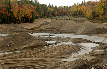
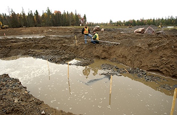
Work: A crew works on restoration of the stream channel on the Dead River in Marquette County.
|