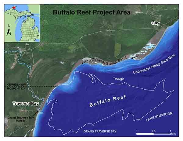
The multi-agency Buffalo Reef Task Force is moving forward with its ongoing campaign to protect the valuable fish spawning and rearing habitat in and around the natural 2,200-acre reef, situated off the eastern coast of the Keweenaw Peninsula.
Over the past roughly 100 years, historic copper mine tailings from the Wolverine and Mohawk mines – called stamp sands – were deposited at a milling site along Lake Superior, located in the community of Gay in Keweenaw County.
Since that time, the stamp sands have been moved by winds and waves south down the shoreline roughly 5 miles, inundating natural sand beach areas and threatening to cover spawning habitat and recruitment areas important to Lake Superior whitefish and lake trout associated with Buffalo Reef. The valuable reef is located beneath the waters of Grand Traverse Bay.
“We had hoped hold a meeting this summer to update the public on activities that have taken place over the past few months, as well as outline where we now stand and what’s next,” said task force member Stephanie Swart, Lake Superior coordinator for the Michigan Department of Environment, Great Lakes and Energy. “Coronavirus meeting restrictions forced us to cancel this opportunity.”
Instead, the task force has produced a newsletter detailing a timeline of activities, new developments, technology being employed and fisheries research taking place.
DOWNLOAD THE NEWSLETTER HERE
Among the plans for the remainder of this year, the U.S. Army Corps of Engineers is expected to develop 30% (of project completion) engineering designs, including costs, for the three top alternatives under consideration for long-term protection of Buffalo Reef.
These alternatives include building an in-lake barricade around the original stamp sands pile to contain it, disposing of stamp sand in a nearby landfill or hauling the material to the mine tailings basins at the former White Pine Mine in Ontonagon County.
After the designs are completed, the task force anticipated soliciting public input by December 2021 on which alternative management plan is best for protecting Buffalo Reef.
Meanwhile, research on fish eggs and fry (young fish), as well as the chemical and physical properties of deposited stamp sands, is planned for next year. A camera is anticipated to be installed at the Grand Traverse Harbor to monitor Lake Superior waves and ice shove.
To help combat the threat posed to the reef and the harbor by the migrating stamp sands, various dredging efforts have taken place over the past few years, including removal of a 25-foot-high bank from the Lake Superior shoreline in 2019. Harbor dredging efforts have worked to keep the waterway open for fishing, boating and other recreation.
The reef project, funded through the Great Lakes Restoration Initiative, is being executed in cooperation with the U.S. Army Corps of Engineers, U.S. Environmental Protection Agency, Keweenaw Bay Indian Community, the Great Lakes Indian Fish and Wildlife Commission, the Michigan Department of Natural Resources and the Michigan Department of Environment, Great Lakes and Energy to save the 2,200-acre reef.
For more information on the ongoing effort to save Buffalo Reef, or to sign-up for the latest email updates, visit Michigan.gov/BuffaloReef.
|