High water impacts continue across Michigan
By JOHN PEPIN
Michigan Department of Natural Resources
From the Porcupine Mountains to Lime Island and Harrisville to Tawas and Van Buren state parks, record or near-record Great Lakes water levels have produced powerful impacts forcing the closure of numerous facilities.
These impacts include flooding, extensive erosion and destruction or damage to countless shoreline features, ranging from homes to harbors.
Along with the closure of campsites, trails, roads, boating access sites and recreation areas, high water levels have also created numerous hazards for boaters, swimmers and even wildlife.

“Over the past few years, the rising Great Lakes have posed significant challenges to maintaining our recreation facilities across the state,” said Ron Olson, chief of the Michigan Department of Natural Resources’ Parks and Recreation Division. “In turn, these challenges have increased costs to our already strapped infrastructure improvements budget, even before the additional impacts from the coronavirus pandemic.”
Among the noted closures affecting DNR-managed facilities are more than 20 boating access sites, campsites at Harrisville, Leelanau, Muskegon and Young state parks and submerged electrical conduits at Mackinac Island State Harbor.
Lime Island Recreation Area, in the eastern Upper Peninsula, is closed for the season because of submerged docks, as is the Hammond Bay State Harbor on Lake Huron.
Olson said Orchard Beach State Park in Manistee has had acute shoreline damage, forcing relocation of a historic shelter, which is in danger of falling into Lake Michigan. The storm water drainage system is also being redesigned to help protect the eroding bank. The cost for those activities tops $3 million.
Records and reasons
According to the U.S. Army Corps of Engineers, except for Lake Ontario, the remaining four Great Lakes and Lake St. Clair each have logged monthly mean high water records at some point this year. Lake Ontario last hit a record high in September 2019.
|
Annual water levels, fueled by snowmelt and rainfall, rise in the spring to midsummer – when there is increased sunshine, warmth and evaporation – and then start to decline into fall where they remain throughout the winter as snow accumulates.
Depending on rainfall dynamics, the waters of all five of the Great Lakes are projected to subside below record levels by the end of the year. Preliminary estimates show precipitation in the Great Lakes Basin was slightly below average in June.
“The primary drivers of water level fluctuations are changing weather patterns and resulting fluctuations in water supply,” said Chris Warren, a professional engineer with the Army Corps’ Detroit District.
The Great Lakes Basin includes 14,000 miles of shoreline along eight states and two Canadian provinces, with 200,000 square miles of land and 95,000 square miles of water. The basin covers a total of 2,212 miles from eastern Minnesota and northern Wisconsin to the Gulf of St. Lawrence in the Atlantic Ocean.
After more than a decade of low Great Lakes water levels, including record lows, the trend toward higher water began in 2013, marked by a record rise and record highs, Warren said.
|
Through December 2019, according to the National Oceanic and Atmospheric Administration’s National Centers for Environmental Information, the preceding 12-, 24-, 48- and 60-month periods were the wettest on the Great Lakes in more than 120 years.
“We’re seeing some of the highest water levels in recorded history on the Great Lakes,” said Keith Kompoltowicz, chief of the Army Corps’ Watershed Hydrology Branch. “And that’s the result of very wet weather experienced over the last several years.”
Widespread effects
The Michigan Sea Grant website said “even shallow, slow-moving floodwaters can become a major hazard.
“In addition to damaging homes, businesses, power lines, agricultural fields, roadways and other infrastructure, extreme storms and floods can also wash high levels of nitrogen, phosphorus and other nutrients into rivers and streams, where they can lead to harmful algae blooms, give invasive fish and plant species new routes for moving from one water body to another, create damp environments that encourage the growth of mildew, mold, harmful bacteria and mosquito larvae, tempt people to swim, drive, fish, wade or boat in potentially hazardous waters. Fast-moving currents, underwater obstructions and waterborne contaminants can all threaten the health and safety of people who take risks in floodwaters,” the website states.
Michigan DNR conservation officers have offered important tips for boaters given the high-water conditions prevailing on many waterways across the state.
“Some of our officers have witnessed vessels attempt to take a shortcut through channels marked by a buoy. Buoys and markers are in place to communicate a change in water levels that could pose a risk to boaters, including obstacles under the surface of the water or shallow water that has recently become impassable,” said Gary Hagler, chief of the DNR Law Enforcement Division. “Each conservation officer is assigned to patrol specific areas of the state, so they are familiar with the fluctuating water levels. We recommend researching the area you’ll be navigating and remaining vigilant to all markers and buoys.”
|
Higher waters can cause fast-flowing currents, deeper and colder water, unpredictable conditions and more debris floating under the water’s surface – especially on rivers. The law requires that all vessels, including kayaks and canoes, be equipped with a personal flotation device for each person on board.
Task force formed
After a Michigan High Water Coordinating Summit in February, convened by Gov. Gretchen Whitmer, several governmental agencies created the Michigan High Water Action Team to facilitate collaboration and resource sharing in response to public health and safety challenges posed by the state’s historic highwater levels.
Members of the team include the Michigan departments of natural resources, state police, health and human services, insurance and financial services, and environment, great lakes and energy, in addition to groups representing local and federal officials.
"High water levels affect every corner of the state, from Great Lakes shorelines to inland lakes to rivers and canals," said Liesl Clark, Michigan Department of Environment, Great Lakes and Energy director. "There is no short-term end in sight, which means homeowners and communities will feel the impacts for quite some time. The Michigan High Water Action Team will make sure we continue to have robust discussions at all levels of government to help all Michiganders."
The U.S. Army Corps of Engineers, Detroit District, said its personnel are “committed to ensuring public safety while providing technical expertise and assistance during this time of high water around the Great Lakes.”
“During response operations, our Emergency Management Office, conducts emergency operations to save lives and protect improved properties,” the Army Corps states on its website. “In the event of natural disasters, such as flooding, emergency permit procedures can be activated to expedite permits to reduce further damage and protect life and property.”
|
The Army Corps has authority to provide technical and planning assistance for floodplain management planning. The Great Lakes Hydraulics and Hydrology Office forecasts and monitors water levels of the Great Lakes and the conditions that lead to water level fluctuations.
The Army Corps maintains a webpage on Great Lakes high water. More information is available at Michigan.gov/HighWater and a high water webpage maintained by the DNR.
Additional concerns
Beyond the Great Lakes, problems with high water levels also have been persistent on inland waters, including lakes and streams.
Inland water levels vary from place to place given winter snowfall, the water content of that snow and rainfall amounts. Precipitation also has raised groundwater levels.
“All of this means water has less places to go, and frequency and magnitude of flooding events can increase,” said the Michigan Department of Environment, Great Lakes and Energy’s webpage on high water.
Various watercraft controls and other restrictions have been put in place to protect people and property.
In addition to numerous hazards that may be encountered by boaters given high water levels, swimmers and waders can underestimate the strength and power of lake currents leading to dangerous and tragic circumstances.
There have been more than 50 drownings reported on the Great Lakes this year, most from Lake Michigan.
|
Piers and river mouths are places where high water and rip currents can pose serious risks. It’s best to swim at designated beaches, where you can keep an eye on the beach flag warning system and easily monitor swim conditions.
Olson said beyond high water levels, boaters and swimmers disregarding red flag warnings and swimming in restricted areas, like off breakwaters and within navigational channels, also have produced dangerous circumstances.
DNR conservation officers and other police and emergency personnel have responded to several incidents of boaters or swimmers in trouble.
The U.S. Coast Guard reported its busiest Independence Day weekend in the last five years, responding to more than 100 search-and-rescue calls and saving or assisting more than 300 people throughout the region.
Despite those successful efforts, two lives were lost on the lakes during the July 3-5 holiday weekend.
Coast Guard officials said then the guard was approximately 200 search-and-rescue cases ahead of 2019’s pace and about 60 cases over the five-year average.
High activity has since continued to be reported. For the last weekend in July, the Coast Guard said crews throughout the Great Lakes were involved in 81 cases, saved 56 lives and assisted 264 people.
The DNR maintains a webpage with Great Lakes beach safety tips.
Impacts to wildlife
High water also can produce negative circumstances for wildlife.
DNR wildlife biologists say many wildlife species are adaptable and can relocate when high water threatens their habitat. However, some ground-nesting birds like eastern meadowlarks, wild turkeys, mallards and piping plovers can experience nest failures when flooding occurs, which can mean the loss of young birds.
Wakes generated by watercraft also can have harmful impacts for wildlife. To help alleviate flooding, wake restrictions are in place to protect shoreline habitat for fish and animals.
With continued dangers to people, property and wildlife posed by high water levels across Michigan, the DNR is urging anyone venturing out on the water – from anglers and boaters to swimmers, waders and beachcombers – to remain alert and aware of potential hazards to help prevent accidents and help keep everyone enjoying the state’s wonderful water resources safe.
For more information on high water, including links to beach and boating safety tips, local boating restrictions and facility closures, visit Michigan.gov/HighWaterSafety.
|
Check out previous Showcasing the DNR stories in our archive at Michigan.gov/DNRStories. To subscribe to upcoming Showcasing articles, sign up for free email delivery at Michigan.gov/DNR.
/Note to editors: Contact: John Pepin, Showcasing the DNR series editor, 906-250-7260. Accompanying photos and a text-only version of this story are available below for download. Caption information follows. Credit Michigan Department of Natural Resources, unless otherwise noted.
Text-only version - High Water
Boaters: Boaters tie up to the dock after a fishing trip in 2019 at the Lime Island Recreation Area in the eastern Upper Peninsula. High water levels, which covered docking facilities, forced closure of the recreation area for the 2020 season.
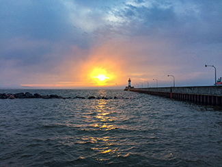
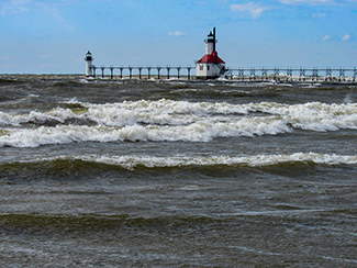
Breakwater: The U.S. Army Corps of Engineers reported earlier this year that the Great Lakes were still sitting record high water levels.
McLain-1 and McLain-2: Significant erosion plagued F.J. McLain State Park in Houghton County early in the Great Lakes high water levels crisis. Campsites, a park road and other features needed to be moved away from the shoreline.
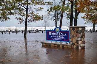
Park: A vicious storm, with the help of high lake levels on Lake Superior, in October 2017 caused severe damage to Shiras Park in Marquette.
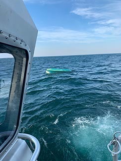
Rescue: A Coast Guard crew from Station Niagara locates a capsized 15-foot sailboat near Waterport, New York, July 26, 2020. Two men aboard were rescued after they were reported overdue. (U.S. Coast Guard photo)
Shoreline: Erosion at Grand Mere Lakes on the southeastern shore of Lake Michigan. (U.S. Army Corps of Engineers photo)
South Haven: The pier at South Haven inundated with raging waters in April. (J. Sandberg, Michigan Sea Grant photo)
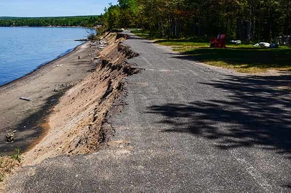
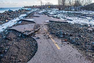
Storms: High Lake Superior water levels and strong storms severely damaged portions of Lakeshore Boulevard in Marquette, forcing city officials to close the popular route. New construction is rerouting the road away from the lake.
Trail: A work crew repairs erosion along the Iron Ore Heritage Trail at Lake Superior in south Marquette. The trail was undermined by high water levels and wave action. This segment of trail is also part of the Iron Belle Trail and the North Country National Scenic Trail./
|