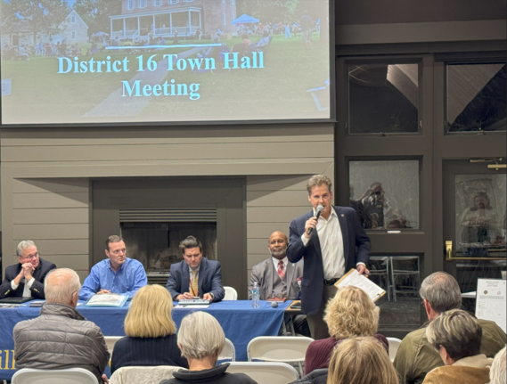
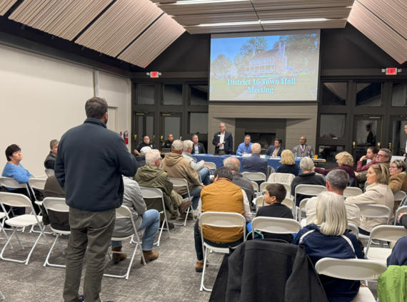
 We had an excellent turn out Wednesday night at the District 16 Town Hall meeting at Historic Locust Grove!
Thank you to KYTC, LMPD, Public Works, Metro Parks, Louisville Water Company, State Rep Ken Fleming, and Deputy Mayor Nicole George for attending and answering excellent questions from District 16 constituents!
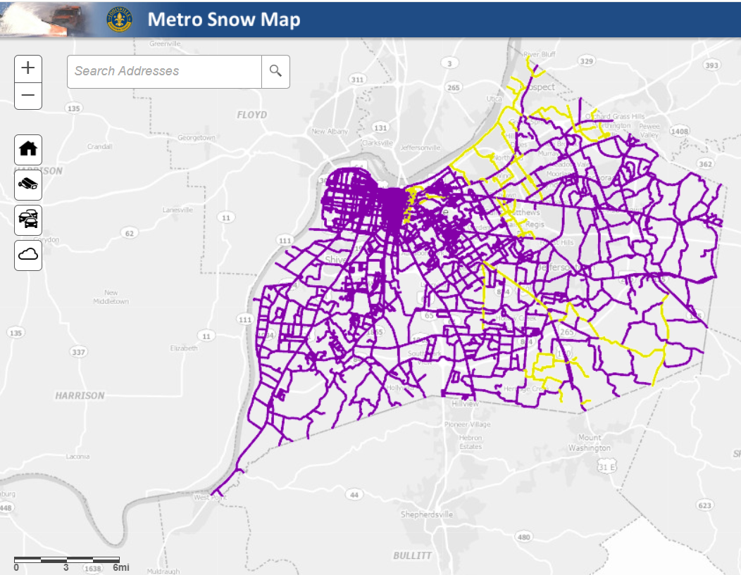 Louisville Metro’s Snow Map is the best resource for residents to check snow route coverage and monitor treatment progress during a storm.
What are snow routes?
Louisville Metro treats and plows only the roads included in our 111 officially designated snow routes. These routes are selected because they carry the highest traffic volumes, connect neighborhoods to major corridors, and provide access to hospitals, schools, emergency services, and major employers.
Neighborhood streets and private roads are not part of Louisville Metro’s snow routes, and interstates and ramps are maintained by the Kentucky Transportation Cabinet (KYTC).
If your street isn’t on a Metro snow route and you live within a suburban city or municipality in Jefferson County, snow removal may be handled by your local government. Residents should check with their city hall or public works department for specifics.
Residents whose streets are not included should also consider planning ahead with neighbors, homeowner associations, or property managers to manage local snow and ice removal.
How to use the Snow Map
The Snow Map helps residents see which Metro routes have been treated or plowed during an active snow event.
Here’s how to use it:
- Visit louisvilleky.gov/snow and select “Snow Map.”
- Type your address into the search bar to see whether your street is part of a Metro snow route.
- View treatment progress; the map shows when a roadway on a Metro route was last treated or plowed.
- Keep in mind that a road marked as “plowed” does not mean it is fully clear or dry — especially if snow continues to fall or temperatures remain below freezing.
The Snow Map helps residents understand where crews are working, which roads are included in Metro’s responsibilities, and how snow operations progress during a storm. It also helps drivers make more informed travel decisions during winter weather.
For storm updates and to access the Snow Map, visit louisvilleky.gov/snow.
 |
|
What's New This Snow Season
|
Staffing Improvements
Louisville Metro has strengthened snow operations staffing for the 2025 - 2026 winter season:
- The Roads and Maintenance Division is nearly fully staffed this year.
- Louisville Parks and Recreation has added 18 additional staff members, bringing its snow team to more than 30 employees.
- Dispatch staffing has been increased to improve coordination and communication during storms.
Equipment and Upgrades
Louisville Metro Government has made significant investments in new and improved equipment to support snow operations citywide:
- Eight new tandem-axle dump trucks and at least three pickup trucks equipped with plows, bringing the total snow-fighting fleet to more than 100 vehicles.
- Sixteen new brine tank replacements (five already delivered), maintaining a total of 24 tanks across the city for pretreating roads.
- New curb guards on all plows to help protect curbs, mailboxes, and pavement edges while extending blade life.
- Upgraded plow blades with tough carbide cutting edges, which are stronger and more durable than standard steel. These blades last longer and reduce downtime for maintenance.
Expanding Brine Operations
Louisville Metro Government will brine more this year. Brine is a liquid mixture of salt and water that helps prevent ice from bonding to pavement before a storm hits. This upgrade allows Louisville Metro to treat more roads in advance, improving safety and reducing salt use overall. However it's not appropriate to brine if rain is in the forecast, since rain can was away the solution before temperatures drop.
Enhanced Communications
Louisville Metro Government is improving communication before, during, and after winter weather events. Routine updates will be shared on this Snow Removal webpage to keep residents informed on storm progress and priorities, as well as to set clear expectations for service levels.
Metro is also enhancing internal coordination among departments and strengthening communication with partner agencies such as KYTC, JCPS, TARC, and MSD to ensure timely information sharing and a unified response during winter weather.
For storm updates, details on the snow removal process, and to access the Snow Map, visit louisvilleky.gov/snow.
 National Wreaths Across America Day is December 13, 2025 at 12 p.m. (Wreath Placement Immediately Following Ceremony) at Zachary Taylor National Cemetery. We're getting closer to our goal, and we need your help to make sure every veteran's grave at our local cemetery is honored with a wreath.
Every December, National Wreaths Across America Day brings the mission—Remember, Honor, and Teach—to life. Volunteers coordinate wreath-laying ceremonies at Arlington National Cemetery and more than 5,200 locations across all 50 states, at sea, and abroad, honoring the service and sacrifice of our nation's veterans. Last year, more than 3 million veteran wreaths were placed nationwide!
At Zachary Taylor National Cemetery, there are 11,400 veterans to honor. The goal is to place 11,400 wreaths this year and the total is at 57% currently. Your support can make all the difference! Each wreath you sponsor get makes it one step closer to honoring every veteran at this location.
Sponsor wreaths today by visiting KYZTNL - Zachary Taylor National Cemetery and clicking the Red Sponsor button. Thank you for helping honor every American hero—your support makes a meaningful difference!
 Details:
- Purchase $25 gift cards (Target and Walmart)
- Drop gift cards by Eastern Area Community Ministries, Mon – Thurs 10am-2pm, 9104 Westport Road
OR Mail them to EACM, PO Box 43049, Louisville, KY 40253
Donation deadline December 15th

Mayor Greenberg and the Louisville Zoo are excited to announce a monthlong celebration in December filled with activities for the whole family. From animal-themed holiday enrichment to visits from Santa and Mrs. Claus, there's something to amaze the whole family. Plus, discover unique gifts that offer a whole year of fun for the recipient.
“The Zoo is a vibrant part of our city’s winter season and offers a wonderful way for families to connect and make holiday memories,” said Mayor Craig Greenberg. “Having events like these is a great example of how we can have fun while giving back to our neighbors and building a stronger and healthier Louisville together.”
Event highlights for December
-
Beary Happy Holiday (Weekends: Dec. 6 – 7, 13 – 14, 20 – 21) Join animal friends throughout the Zoo as they enjoy special holiday-themed enrichment activities.
-
Santa and Mrs. Claus Visit (Dec. 20 – 21, 10 a.m. to 2 p.m.) The beloved couple of the season will make a last-minute stop at the Louisville Zoo to meet and take photos with guests. Families can also enjoy sweet treats (additional fee) during this special weekend.
-
Holiday Scavenger Hunt (All Month) Guests can embark on a Zoo-wide scavenger hunt for all ages. Scan the QR code at the Zoo entrance to join the adventure and complete challenges for a chance to win Zoo-themed prizes.
Additional Details
The Zoo is open year-round with cozy indoor spaces. Holiday programming is included with general Zoo admission or membership. Visitors can also take advantage of discounted admission during Wild Winter Days, presented by Kroger, running through February 28, 2026. Guests who bring at least one non-perishable food item per person for Dare to Care Food Bank can purchase tickets at the Zoo for $11 per adult and $8 per child/senior.
For a complete schedule of events and activities, visit louisvillezoo.org/events
Gift Giving Ideas
Memberships: The gift that truly keeps on giving for the recipient — for a full year, in fact — is the Louisville Zoo membership. Purchase between Nov. 28 to Dec. 1 and enjoy $10 off any membership or gift voucher purchased online. The first 1,000 redemptions will receive a free plush animal. After Dec. 1, receive $5 off through Dec. 26 on holiday Zoo memberships. For a full list of memberships visit louisvillezoo.org/members.
Gift shop: Located at the front of the Zoo, the gift shop is open daily from 10 a.m. to 5 p.m., and no admission is required to shop. The Zoo’s gift shop boasts the largest and most unique variety of plush animals for any animal fan, a curated selection of handmade goods, eco-friendly treasures and wild Zoo apparel. Plus, Louisville Zoo members receive 10 percent off select merchandise.
Adopts: The Zoo has a perfect gift that supports wildlife. Through the Zoo’s ADOPTS (animals depend on people to survive) guests can symbolically adopt a Zoo animal. See the full list of adoptable animals and benefit levels at louisvillezoo.org/adopts.
Honorary gift ideas: Honor someone meaningful this holiday season with a personalized Louisville Stoneware plaque installed in Irvin and Alice’s Garden near the sloth habitat. Installation timelines vary based on production and weather. A card will be provided to notify the gift recipient. Visit louisvillezoo.org/support for information or to order.
Gifts for Zoo animals: Help animals at your Zoo thrive! Donate enrichment items that encourage natural behaviors, stimulate curiosity, and support overall well-being. Browse the online wish list and give a gift directly to the animals this season at louisvillezoo.org/wishlist.
Zoo Hours
The Zoo is open daily year-round. Now through March 20, 2026, hours are 10 a.m. to 4 p.m., with guests exiting by 5 p.m. The Zoo is closed on Thanksgiving, Christmas, and New Year’s Day. Visit louisvillezoo.org for more information.
We’ve got an awesome dog to share with you, her name is TWIGGY! Twigs was taken from a neglectful owner but isn’t letting that get her down. Twiggy is housetrained too, no messes for this mature madam! Twiggy is around 5yrs old and abouts 50lbs. Twiggy knows sit, lay down, and paw! She is a smartie pants and easy to train because she LOVES food!!
Twiggy is a CHAMPION at #YourCityShelter! That means her adoption comes with perks! No adoption fee, Freedom Harness with leash, crate, starter bag of food, and 6 months of heartworm prevention. She will also have a lifetime free license and a 3 years of core vaccines thanks to Friends of Metro Animal Services. Twigs is available for SAME DAY ADOPTION!
Visit at Louisville Animal Services, 3576 Newburg Road, Louisville, 40218, Sunday-Saturday Noon-6pm.

New items or changes in project status are shown in bold
Inclement weather or other unforeseen circumstances may arise, and as such, the information provided below is for advisory purposes only and subject to change without prior notice.
Pothole patching, sweeping, drain & ditch cleaning, striping, pavement marking, and maintenance crews may work on major interstates during non-peak daytime hours and at night. Motorists should watch for roadside maintenance on interstates and highways daily throughout the district.
| Jefferson County |
|
| I-65 Central Corridor |
Information related to the I-65 Central Corridor project can be found online at i65centralcorridor.com.
|
U.S. 31E (Main Street)
*Main Remade* |
*Construction phasing details, including traffic impacts, are available online at: www.MainRemade.com
Latest press release:
https://lnks.gd/2/33z8p--
|
| I-64 East and West |
Traffic Impacts: Westbound traffic is currently onto the newly constructed bridge, and eastbound traffic is shifted to the median to allow contract crews to continue the demolition and reconstruction of the eastbound structure.
Date/Time: Daily/nightly.
Project Limits: I-64 East and West at mile point 11.799, near Exit 10 (Cannons Lane) on I-64 West, and near Exit 12 to I-264 (Watterson Expressway) on I-64 East.
Type of Work: Bridge replacement project.
Other Details: *Project announcement press release
|
| I-65 South |
Traffic Impacts: Lane reduction and road closure.
Date/Time: Through Dec. of 2025.
Project Limits: I-65 South bridge at Exit 136C to Jefferson Street in downtown Louisville.
Type of work: Bridge maintenance project.
Other Details: During construction, the bridge will be reduced to a single 10-foot lane. Wide loads will not be permitted to use the ramp, and signage will be posted in advance to alert drivers of the restriction. In addition, South Floyd Street will be closed between East Jefferson Street and East Liberty Street. Drivers should follow the signed detour: East Liberty Street to South Jackson Street, left onto East Jefferson Street, and back to Liberty Street. Motorists are encouraged to plan ahead, follow posted signage, and use caution when driving through the work zone. |
| I-65 South (John F. Kennedy Memorial Bridge) |
Dec. 12, 2025 project update (I-65 South to I-64 West ramp closure extended through Dec. 24): https://lnks.gd/2/35bWbbr
Nov. 20, 2025 project update:
https://lnks.gd/2/35Np_m-
-----------------------------------------------
Traffic Impacts: Closure of the right three lanes.
I-65 South (John F. Kennedy Memorial Bridge).
Type of Work: Expansion joint replacement project.
Other Details: The right three lanes and right shoulder of the bridge carrying I-65 South over the Ohio River will remain closed through the end of 2025 for ongoing construction activities. While lane closures span the entire length of the bridge, access to I-64 and I-71 will be maintained throughout the duration of the work.
*Jul. 28, 2025 press release
*Jun. 3, 2025 press release
*Mar. 31, 2025 press release
*Feb. 27, 2025 press release
|
| I-264/U.S. 42 (Brownsboro Road) Improvement Project |
**Traffic impacts available here.**
|
| KY 841 East (Gene Snyder Freeway) |
Traffic Impacts: Closure of the right lane.
Date/Time: From Tuesday, Dec. 16, at 7 p.m., through Thursday, Dec. 18, at 12 p.m.
Project Limits: The left lane of KY 841 East (Gene Snyder Freeway) will be closed between mile markers 7 and 8 (near KY 1020/National Turnpike).
Type of Work: Concrete slab repairs.
Other Details: The lane closure is necessary for contract crews to repair concrete slabs along the corridor and allow sufficient curing time, which typically takes about 24 hours to reach adequate strength for traffic. Motorists are urged to follow all lane closure restrictions and exercise caution in the work zone. |
| KY 864 (Logan Street/Shelby Street) |
Traffic Impacts: Sidewalk and lane closures are possible.
Date/Time: Daily and nightly.
Project Limits: Between Goss Avenue and East Gray Street.
Type of Work: One-way to two-way conversion of the roadway.
Other Details: Major work has resumed, with full completion expected by Spring 2026.
*Project Webpage
|
| KY 1819 (Billtown Road) |
Traffic Impacts: Lane closures and delays are possible.
Date/Time: Daily – 9 a.m. to 4 p.m.
Project Limits: Three sections of KY 1819 (Billtown Road):
- Easum Road through Mary Dell Lane
- Michael Edward Drive through Fairground Road
- Shady Acres Lane through Colonnades Place
Type of Work: Reconstruction of KY 1819 (Billtown Road) from North of Colonnades Place to south of Easum Road with new traffic signals, signal optimization, turn lanes, storage lanes, etc. (varying by intersection based on existing conditions and future traffic projections).
Other Details: The reconstruction project is expected to be completed by the Spring of 2026.
*Project webpage
|
I-264
*Various Exit Ramps |
Traffic Impacts: Ramp narrowing with intermittent lane and shoulder closures.
Project Limits: Various interchange Exit ramps on I-64 and I-264.
Type of Work: Installation and upgrade of wrong-way pavement markings and signs.
Other Details: The Highway Safety Improvement Project will install and enhance wrong-way signs and pavement markings on interstate Exit ramps to discourage wrong-way driving. Motorists should reduce speeds and obey traffic control while workers are present. This project is expected to be completed by the Fall of 2025. |
| |
|
| Bullitt County |
|
| KY 1526 (Bells Mill Road) |
Traffic Impacts: Road closure.
Date/Time: Beginning Monday, Nov. 17, through May 14, 2026.
Project Limits: KY 1526 (Bells Mill Road) will be closed at mile point 14.35 at the bridge over Floyds Fork.
Type of Work: Superstructure replacement.
Detour:
- For westbound traffic on KY 1526 (Bells Mill Road): Turn left onto KY 61 (Preston Highway) south toward Shepherdsville. At the signalized intersection, turn left onto KY 44 (East 4th Street) to reach KY 1526 (Bells Mill Road).
- For eastbound traffic on KY 1526 (Bells Mill Road): Turn right onto KY 44 (East 4th Street) through Shepherdsville. At the signalized intersection of KY 61 (Preston Highway), turn right to then reach KY 1526 (Bells Mill Road).
|
| |
|
| Franklin County |
|
| KY 12 (Flat Creek Road) |
Traffic Impacts: N/A.
Date/Time: Beginning Aug. 11, through the Fall of 2026.
Project Limits: KY 12 bridge over Flat Creek at mile point 12.46 (at the Franklin/Henry County line).
Type of Work: Bridge replacement project.
Other Details: Traffic will be maintained on the existing bridge until construction has been completed on the replacement bridge. |
| I-64 East and West |
Traffic Impacts: Lane closures and traffic shifts are possible.
Date/Time: Daily/nightly beginning Thursday, Sept. 4.
Project Limits: The I-64 East and West, between the Frankfort exits (mile markers 53 and 58).
Type of Work: The I-64 improvement project, between the Frankfort exits (mile markers 53 and 58), includes the milling and removal of the existing asphalt surface followed by resurfacing with new asphalt pavement. Other improvements to the 5-mile corridor include bridge repairs and bridge crash wall repairs.
Other Details:
- U.S. 60 (Versailles Road):
U.S. 60 (Versailles Road) will be reduced to one lane in each direction under the I-64 overpass bridge nightly from 9 p.m. to 6 a.m. beginning Monday, Sept. 15.
** The left lane of I-64 East at mile point 53.15 (near U.S. 127) and at mile point 57.1 (near Hanly Lane) will be closed from 7 p.m. Tuesday, Dec. 16, through 6 a.m. Wednesday, Dec. 17. The overnight lane closures are necessary for contract crews to perform bridge work. **
|
| U.S. 127/Vandalay Drive Intersection |
Traffic Impacts: Lane closures and traffic shifts are possible.
Date/Time: Daily/nightly.
Project Limits: U.S. 127/Vandalay Drive intersection.
Type of Work: The scope of the project includes constructing a new roundabout at the intersection of Vandalay Drive and Westridge Drive; extending Vandalay Drive to Limestone Drive to create a direct connection to KY 676 (East-West Connector); extending Vandalay Drive to U.S. 127 near the I-64/U.S. 127 interchange; and adding dual receiving lanes to improve left-turn movements from U.S. 127 onto Westridge Drive.
Other Details: The project is scheduled to be completed by the summer of 2026. |
| |
|
| Oldham County |
*Routine Maintenance* |
| |
|
| Spencer County |
*Routine maintenance* |
| |
|
| Shelby County |
|
| I-64 Widening and Improvement Project |
**Traffic impacts here.**
|
| |
|
| Henry County |
*Routine maintenance* |
| |
|
| Trimble County |
*Routine maintenance* |
| |
|
2025 Resurfacing Projects
Resurfacing projects will begin April 1, 2025, and
will be completed by the Fall of 2025.
Motorists should heed signage and use caution when traveling through the work zone.
| County / Road Name: |
Project Limits: |
| Jefferson County |
|
| U.S. 60 (Shelbyville Road) |
Begin at an asphalt joint west of U.S. 60A extending east to 53 ft west of Sherburn Ln Spur Conn/Ten Pin Ln, a distance of 01.85 miles |
| U.S. 60 (Shelbyville Road) |
Begin at Urton Lane/North English Station Road, extending east to an asphalt joint 0.038 miles west of Beckley Woods Drive/English State Way. |
U.S. 31 (West Main Street)
|
West Main St (US 31W southbound only) begins at US 150/West Main St, extending south to 145 ft north of US 31, a distance of 1.78 miles. |
| KY 907 (Valley Station Road/Third Street Road) |
Begin at U.S. 31E extending north to Arnoldtown Road, a distance of 3.99 miles |
| KY 1065 (Outer Loop) |
Begin at KY 907 extending east to a concrete joint at KY 1020, a distance of 02.48 miles |
| KY 61 (Preston Highway) |
Begin at the north end of the bridge over I-265 extending north to 0.026 miles south of Okolona Ter, a distance of 01.86 miles |
KY 1230 (Lower River Road)
|
From Tennis Blvd, west 0.093 miles, extending northerly to KY 1934, a distance of 2.62 miles. |
KY 2830 (Arthur Street)
*Completed* |
KY 2830 (Arthur Street) east of Brandies Avenue/KY 61 extending north to University Boulevard. |
U.S. 31E (Bardstown Road)
*Completed* |
U.S. 31E (Bardstown Road) at the Bullitt/Jefferson County line, extending south of Colonel Hancock Drive. |
KY 1631 (Crittenden Drive)
*Completed* |
KY 1631 (Crittenden Drive) at the beginning of state maintenance near the I-264 interchange, extending north to U.S. 60A (Eastern Parkway). |
KY 1531 (Johnson Road)
*Completed* |
KY 1531 (Johnson Road) from the railroad crossing extending north to Aiken Road. |
KY 61 (Arthur Street)
*Completed* |
KY 61 (Arthur Street) beginning east of Brandies Avenue extending north to I-65 ramp/East Gaulbert Avenue. |
KY 155 (Taylorsville Road)
*Completed* |
KY 155 (Taylorsville Road) beginning at KY 1747 (Hurstbourne Lane) extending north to KY 1932 (Breckenridge Lane). |
KY 329 (Covered Bridge Road)
*Completed* |
KY 329 (Covered Bridge Road) beginning at U.S. 42 extending east to the Jefferson/Oldham County line. |
| |
|
| Bullitt County |
|
KY 61 (Old Preston Highway)
|
Begin at KY 61 extending north to 0.165 miles north Hillsbrook Dr, a distance of 0.87 miles
|
KY 61 (North Preston Highway)
|
Begin 21 ft north of KY 2553 extending north to Bullitt/Jefferson County line, a distance of 01.58 miles
|
| KY 480 (Cedar Grove Road) |
Begin 0.113 miles east of Park Loop Rd/Valley Vw Dr extending east to 0.077 miles east of KY 1442, a distance of 0.42 miles |
KY 1442 (Ridge Road)
|
Ridge Rd/Clarks Ln from McCubbins Farm Ln, south 0.056 mile, extending easterly towards Paddock Rd, a distance of 4.90 miles. |
KY 1604 (Deatsville Road)
|
From KY 245, extending northerly towards Jackson Hollow Rd, a distance of 3.20 miles. |
KY 1531 (Dawson Hill Road)
*Completed* |
KY 1531 (Dawson Hill Road) from KY 1319 extending north to the Bullitt/Jefferson County line. |
KY 2672 (Knob Creek Road)
*Completed* |
KY 2672 (Knob Creek Road) from KY 1526 (Brooks Hill Road) extending north towards Lake Elmo Road. |
KY 2674 (Stringer Lane)
*Completed* |
KY 2674 (Stringer Lane) from U.S. 31E extending north to KY 44. |
| |
|
| Franklin County |
|
| U.S. 60 (Louisville Road) |
Begin at the east end of Benson Creek Bridge extending east to mile point .025 just east of Office Park Drive. |
| KY 12 (Dry Ridge Road/Flat Creek Road) |
KY 12 (Dry Ridge Road/Flat Creek Road) from the Shelby/Franklin County line extending east to Harvieland Road. |
| KY 1570 (St Johns Road) |
KY 1570 (St Johns Road) from the bridge at mile point 4.2, extending north to KY 12. |
| U.S. 127 (Wilkinson Boulevard) |
U.S. 127 (Wilkinson Boulevard) near Hall Street extending north to the south end of the U.S. 127/KY 2261 bridge. |
| |
|
| Oldham County |
|
| KY 53 (North First Avenue) |
Begin at KY 146 extending north to US 42 (MP 11.045), a distance of 03.99 miles |
KY 524 (Westport Road)
|
From US 42, extending northerly towards Smith Ln, a distance of 1 mile. |
KY 362 (Central Avenue)
*Completed* |
KY 362 (Central Avenue) from Rosswoods Drive extending south towards KY 146. |
KY 329 (Covered Bridge Road)
*Completed* |
KY 329 (Covered Bridge Road) from KY 329B extending east to mile point 8.754. |
| KY 393 (Crestwood to La Grange) |
Begin at KY 22 extending north to the south end of the North Fork Bridge, a distance of 1.99 miles |
KY 393 (Payton Lane)
|
From KY 1818, extending northerly to KY 22, a distance of 2.56 miles. |
KY 1694 (Gum Street)
*Completed* |
KY 1694 (Gum Street) from KY 329 extending north towards Mason Lane. |
KY 3223 (Old Sligo Road)
|
From KY 53, extending northerly to Ballard School Rd, a distance of 1.55 miles. |
U.S. 42
*Completed* |
U.S. 42 east of KY 1694 (Gum Street) extending east to the Oldham/Henry County line. |
| |
|
| Shelby County |
|
U.S.421 (Castle Highway)
|
Begin 21 feet north of KY 3322 extending north to KY 55, a distance of 2.82 miles. Castle Highway begins at Henry/Shelby County line extending north to the Shelby/Henry County line, a distance of 0.79 mile. |
KY 22 (Ballardsville Road)
|
Begin at Oldham/Henry County line extending east to KY 55, a distance of 7.02 miles |
KY 362 (Aiken Road)
*Completed* |
KY 362 (Aiken Road) from the Oldham/Shelby County line extending east near Webb Road. |
| U.S. 60 (Frankfort Road) |
U.S. 60 (Frankfort Road) beginning at KY 395 extending east to the Shelby/Franklin County line. |
KY 1408 (Floydsburg Road)
*Completed* |
KY 1408 (Loydsburg Road) from KY 362 extending west to the Shelby/Oldham County line. |
KY 322 (Lucas Road)
*Completed* |
KY 322 (Lucas Road) from KY 53 extending north to the Shelby/Henry County line. |
KY 53 (Mt. Eden Road)
*Completed* |
KY 53 (Mt. Eden Road) beginning at KY 714/KY 44 extending north to KY 1790 (Hooper Station Road). |
| |
|
| Spencer County |
|
KY 1392 (Grays Run Road)
*Completed* |
Begin at the east end of Simpsonville Creek Bridge extending east to KY 55, a distance of 2.64 miles |
KY 1633 (Elk Creek Road)
*Completed* |
KY 1633 (Elk Creek Road) from KY 1135 (Industrial Road) extending north to KY 55.
|
KY 1795 (Mill Road)
*Completed* |
KY 1795 (Mill Road) from Paradise Pointe Road extending east to KY 636. |
KY 55 (Shelbyville Road)
*Completed* |
KY 55 (Shelbyville Road) beginning at KY 155 extending north to the Spencer/Shelby County line. |
| |
|
| Henry County |
|
U.S.421 (Castle Highway)
|
Begin 21 feet north of KY 3322 extending north to KY 55, a distance of 2.82 miles. Castle Highway begins at Henry/Shelby County line extending north to the Shelby/Henry County line, a distance of 0.79 mile. |
U.S. 421 (Campbellsburg Road)
*Completed* |
U.S. 421 (Campbellsburg Road) at the I-71 overpass extending to the Henry/Trimble County line. |
KY 22 (Ballardsville Road)
|
Begin at Oldham/Henry County line extending east to KY 55, a distance of 7.02 miles
|
KY 1360 (Franklinton Road)
*Completed* |
KY 1360 (Franklinton Road) from KY 22 extending north to Bullitt Hill Road.
|
KY 241 (Pleasureville Road)
*Completed* |
KY 241 (Pleasureville Road) beginning at the Shelby/Henry County line extending north to U.S. 421. |
KY 1861 (Smithfield Road)
*Completed* |
KY 1861 (Smithfield Road) from KY 22 extending to KY 322. |
We now have a new way for you to map crime around you. Just click here and view our new interactive crime mapping tool for Division 5 & 8 or for each beat in Division 5 & 8. And save it in your favorites to view crime anytime it's updated daily. On the page is a Quickfind tool that allows you to put your address in and subscribe to crime trends, alerts and block watch reports for your police beat. Forward this email to your friends and family!
For further information on Councilman Scott Reed or District 16 please visit www.louisvilleky.gov/government/metro-council-district-16
You can also reach out directly by phone at 502.574.1116 or by email at scott.reed@louisvilleky.gov.
601 West Jefferson Street
Louisville, KY 40202
Having Trouble Viewing this eNewsletter? Click here to view it on the web.
|