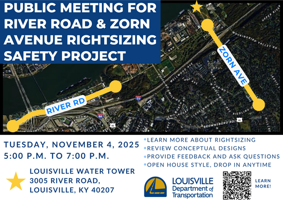    
LOUISVILLE, Ky. (Oct. 24, 2025) – The Kentucky Transportation Cabinet (KYTC) advises motorists of lane closures on Interstate 64 East and West on Tuesday, Oct. 28, in Franklin County.
Consultant engineers will be performing routine in-depth inspections of the I-64 East and West bridges over KY 420 (Old Lawrenceburg Road) near mile point 53.77, from 9 a.m. to 3 p.m. on Tuesday, Oct. 28, requiring closures of the right lanes. Motorists should heed signage and use caution when traveling through the work zone.
The date and duration of this work may be adjusted if inclement weather or other unforeseen delays occur. For the latest traffic and travel updates across the Commonwealth of Kentucky, visit goky.ky.gov. Information specific to District 5 counties is also available on Facebook and X.
Construction activities scheduled for the next month include:
- Work continues on the maintenance building in the southwest portion of the construction site.
- The exterior elevator on the west side of the medical center is planned to be removed in the coming month.
- Road creation and paving are ongoing on the west side of the construction site.
- Enclosure of the medical center is nearing completion.
- Skylight installation in the concourse area is nearing completion.
- Work has begun on permanent perimeter fencing for the site.
- Boilers in the Central Utility Plant are scheduled to begin start-up in the coming weeks.
- Work on the loading dock and laundry facility on the west side of the medical facility continues.
- Work continues on the pump house next to the water tower.
- Interior framing and utility rough is taking place in the East and West Bars of the medical facility.
- Work continues on the guard house near the entrance of the construction site.
- Drywall, insulation and painting are ongoing in the East and West Bar of the medical facility.
- Utilities and equipment installation at the Central Utility Plant continues, as well as exterior masonry.
- Utility and elevator installation continue in the North and South Parking Structures.
Special Note
The architectural construction mock-up at the entrance to the construction site has been removed. It served as a small representation of the construction materials to be used on the main medical center structures. It was built to evaluate and test construction details, materials, and methods. On a much smaller scale, it included various components of the larger hospital project. It was no longer needed now that the medical center exterior is nearing completion.

Louisville tradition for over 40 years!
LOUISVILLE, Ky. (August 28, 2025) – Louisville Mayor Craig Greenberg and the Louisville Zoo are proud to announce the return of “Boo at the Zoo presented by Meijer”, celebrating 44 years of merry, not scary fun! Tickets are on sale now and available at louisvillezoo.org/boo. This beloved event is a Louisville tradition and will begin this year starting September 27 and running through October 30 (Thursday – Sunday nights).
Tickets are all-inclusive and include Boo at the Zoo admission, parking, Spooktacular Carousel, “not-so-itsy-bitsy” Spider House and the Headless Horseman of Sleepy Hollow attraction.
Children and adults are invited to dress up in their wildest costumes for the after-hours event.
Boo at the Zoo turns the Zoo into a living storybook, complete with favorite characters brought to life. There will be music, photo opportunities around every corner and, of course, a safe place to trick-or-treat for kids 11 and under. Guests are encouraged to bring their own trick-or-treat bags, but reusable treat bags will be available for purchase at the Zoo’s Gift Shop (while supplies last).
Tickets:
Tickets for “Boo at the Zoo presented by Meijer” are $13.75 for all non-members ages 3 and older and $7.25 for all members ages 3 and older. Children ages 2 and under are free and do not require a ticket.
Members and guests can purchase tickets online at louisvillezoo.org/boo, with their chosen date and arrival time. Ticket capacity is limited each night with popular nights expected to sell out quickly.
A limited number of Meijer “anytime tickets” can be purchased at participating Meijer stores for $11.75 starting September 21, 2025. Visit louisvillezoo.org/boo for a list of stores.
“Boo at the Zoo presented by Meijer” is a rain or shine event.
Sponsors:
Boo at the Zoo is presented by Meijer and sponsored by Ford Motor Company, Norton Children’s, PNC Grow Up Great and UPS. With additional support provided by Councilwoman Josie Raymond & District 10 residents, Councilman Anthony Piagentini and District 19 residents, Ky Saves 529, and Nu Yale.
“Boo at the Zoo presented by Meijer” provides critical support every year to the Zoo’s animal care programs, visitor experience and conservation education.
Event Hours
On “Boo at the Zoo presented by Meijer” event days:
The Zoo will close early for regular daytime visitors. Gates will close at 3 p.m. with guests being allowed to visit until 4 p.m.
The party starts at 5 p.m. and Halloween guests will enter the Zoo at their ticketed time until 9 p.m. At 10 p.m., the trick-or-treat route will close, and all guests must exit the Zoo.
Special Dates:
Allergy-Friendly Night
Wednesday, October 22; Enter 5 – 7:30 p.m., enjoy until 8:30 p.m.
This special night features peanut-free treat booths and added non-food treats like stickers, pencils and more.
Sensory-Friendly Night at Boo at the Zoo
Wednesday, October 29; Enter 5 – 6:30 p.m., enjoy until 8 p.m.
This night will feature a sensory-friendly trick-or-treating experience with fewer lights, lower music and smaller crowds. Tickets are very limited so purchase early to reserve your spot.
Costume Fun
The Zoo encourages all visitors to wear family-friendly costumes. Adults may join in the fun, however full costume masks that cover the entire face are not permitted for adults.
To learn more about costume guidelines, the event and “Boo at the Zoo presented by Meijer” activities, visit louisvillezoo.org/boo.
Animal Schedules
While you may catch a glimpse of some of our animals, most of the Zoo’s animal ambassadors will not be viewable in the evenings so they can rest and maintain their regular schedules.
Regular Zoo Hours
The Zoo is open daily year-round. Hours through September 21, 2025, are 10 a.m. € 5 p.m. (stay until 6 p.m.). The Zoo is closed on Thanksgiving, Christmas, and New Year’s Day. Visit louisvillezoo.org for more info.
About the Zoo
The Louisville Zoo, the State Zoo of Kentucky, is the top, non-profit, paid attraction in the state. The Zoo is dedicated to bettering the bond between people and our planet by providing excellent care for animals, a great experience for visitors, and leadership in scientific research and conservation education. The Zoo is accredited by the Association of Zoos and Aquariums (AZA).
| Jefferson County |
|
| I-65 Central Corridor |
Information related to the I-65 Central Corridor project can be found online at i65centralcorridor.com.
|
U.S. 31E (Main Street)
*Main Remade* |
*Construction phasing details, including traffic impacts, are available online at: www.MainRemade.com
Latest press release:
https://lnks.gd/2/33z8p--
|
| I-64 East and West |
Traffic Impacts: Westbound traffic is currently onto the newly constructed bridge, and eastbound traffic is shifted to the median to allow contract crews to continue the demolition and reconstruction of the eastbound structure.
Date/Time: Daily/nightly.
Project Limits: I-64 East and West at mile point 11.799, near Exit 10 (Cannons Lane) on I-64 West, and near Exit 12 to I-264 (Watterson Expressway) on I-64 East.
Type of Work: Bridge replacement project.
Other Details: *Project announcement press release
|
| I-64 East |
Traffic Impacts: Lane closure.
Date/Time: From 9 a.m. to 3 p.m. on Thursday, Oct. 30.
Project Limits: I-64 East bridge over U.S. 42 (Mellwood Avenue) at mile point 6.42.
Type of Work: Routine in-depth bridge inspection.
Other Details: Motorists should heed signage and use caution when traveling through the work zone.s |
| I-65 South |
Traffic Impacts: Lane reduction and road closure.
Date/Time: Through Dec. of 2025.
Project Limits: I-65 South bridge at Exit 136C to Jefferson Street in downtown Louisville.
Type of work: Bridge maintenance project.
Other Details: During construction, the bridge will be reduced to a single 10-foot lane. Wide loads will not be permitted to use the ramp, and signage will be posted in advance to alert drivers of the restriction. In addition, South Floyd Street will be closed between East Jefferson Street and East Liberty Street. Drivers should follow the signed detour: East Liberty Street to South Jackson Street, left onto East Jefferson Street, and back to Liberty Street. Motorists are encouraged to plan ahead, follow posted signage, and use caution when driving through the work zone. |
| I-65 South (John F. Kennedy Memorial Bridge) |
Traffic Impacts: Closure of the right three lanes.
I-65 South (John F. Kennedy Memorial Bridge).
Type of Work: Expansion joint replacement project.
Other Details: The right three lanes and right shoulder of the bridge carrying I-65 South over the Ohio River will remain closed through the end of 2025 for ongoing construction activities. While lane closures span the entire length of the bridge, access to I-64 and I-71 will be maintained throughout the duration of the work.
*Jul. 28, 2025 press release
*Jun. 3, 2025 press release
*Mar. 31, 2025 press release
*Feb. 27, 2025 press release
|
| I-264/U.S. 42 (Brownsboro Road) Improvement Project |
*Traffic impacts available here.
|
| KY 864 (Logan Street/Shelby Street) |
Traffic Impacts: Sidewalk and lane closures are possible.
Date/Time: Daily and nightly.
Project Limits: Between Goss Avenue and East Gray Street.
Type of Work: One-way to two-way conversion of the roadway.
Other Details: Major work has resumed, with full completion expected by Spring 2026.
*Project Webpage
|
| KY 1819 (Billtown Road) |
Traffic Impacts: Lane closures and delays are possible.
Date/Time: Daily – 9 a.m. to 4 p.m.
Project Limits: Three sections of KY 1819 (Billtown Road):
- Easum Road through Mary Dell Lane
- Michael Edward Drive through Fairground Road
- Shady Acres Lane through Colonnades Place
Type of Work: Reconstruction of KY 1819 (Billtown Road) from North of Colonnades Place to south of Easum Road with new traffic signals, signal optimization, turn lanes, storage lanes, etc. (varying by intersection based on existing conditions and future traffic projections).
Other Details: The reconstruction project is expected to be completed by the Fall of 2025.
*Project webpage
|
I-264
*Various Exit Ramps |
Traffic Impacts: Ramp narrowing with intermittent lane and shoulder closures.
Project Limits: Various interchange Exit ramps on I-64 and I-264.
Type of Work: Installation and upgrade of wrong-way pavement markings and signs.
Other Details: The Highway Safety Improvement Project will install and enhance wrong-way signs and pavement markings on interstate Exit ramps to discourage wrong-way driving. Motorists should reduce speeds and obey traffic control while workers are present. This project is expected to be completed by the Fall of 2025. |
| KY 2052 (Shepherdsville Road) |
Traffic Impacts: Lane closures.
Date/Time:
The southbound left lane of KY 2052 (Shepherdsville Road) will be closed between mile point 2.13 (near Rural Way) and mile point 3.21 (near East Indian Trail) from 7 p.m. Monday, Oct. 27, through 3 p.m. Wednesday, Oct. 29.
The southbound right lane of KY 2052 (Shepherdsville Road) will be closed between mile point 2.13 (near Rural Way) and mile point 3.21 (near East Indian Trail) from 3 p.m. Wednesday, Oct. 29, through 12 p.m. Friday, Oct. 31.
Type of Work: Concrete slab repairs.
Other Details: The lane closures are necessary for contract crews to repair concrete slabs along the corridor and ensure ample time for the concrete to cure. Motorists should obey all lane closure restrictions, use caution when traveling through the work zone, and plan ahead for increased travel times. |
| |
|
| Bullitt County |
|
| I-65 North |
Traffic Impacts: Closure of the right two lanes.
Date/Time: From 7 p.m. Friday, Oct. 24, to 3 p.m. Sunday, Oct. 26.
Project Limits: I-65 North from mile point 119.8 to mile point 120.5 (near KY 61/Preston Highway).
Type of Work: Concrete slab repairs.
Other Details: The lane closures are necessary for contract crews to repair concrete slabs along the corridor and ensure ample time for the concrete to cure. Motorists should obey all lane closure restrictions, use caution when traveling through the work zone, and plan ahead for increased travel times. |
| I-65/KY 480 (Cedar Grove Road) |
Traffic Impacts: Changing traffic patterns, lane shifts, and lane closures are possible as final construction activities are underway.
Date/Time: Daily and nightly.
Project Limits: KY 480 (Cedar Grove Road) between I-65 (mile points 0.6 and 1.4).
Type of Work: Reconstruction of the KY 480/I-65 interchange, including the construction of a double crossover diamond.
Other Details: The interchange reconstruction project is now in its final configuration. The project is expected to be completed by the Fall of 2025.
|
| |
|
| Franklin County |
|
| KY 12 (Flat Creek Road) |
Traffic Impacts: N/A.
Date/Time: Beginning Aug. 11, through Dec. 1.
Project Limits: KY 12 bridge over Flat Creek at mile point 12.46 (at the Franklin/Henry County line).
Type of Work: Bridge replacement project.
Other Details: Traffic will be maintained on the existing bridge until construction has been completed on the replacement bridge. |
| I-64 East and West |
Traffic Impacts: Lane closures and traffic shifts are possible.
Date/Time: Daily/nightly beginning Thursday, Sept. 4.
Project Limits: The I-64 East and West, between the Frankfort exits (mile markers 53 and 58).
Type of Work: The I-64 improvement project, between the Frankfort exits (mile markers 53 and 58), includes the milling and removal of the existing asphalt surface followed by resurfacing with new asphalt pavement. Other improvements to the 5-mile corridor include bridge repairs and bridge crash wall repairs.
Other Details:
- U.S. 60 (Versailles Road):
U.S. 60 (Versailles Road) will be reduced to one lane in each direction under the I-64 overpass bridge nightly from 9 p.m. to 6 a.m. beginning Monday, Sept. 15.
|
| I-64 East and West |
Traffic Impacts: Closure of the right laned.
Date/Time: From 9 a.m. to 3 p.m. on Tuesday, Oct. 28.
Project Limits: I-64 East and West bridges over KY 420 (Old Lawrenceburg Road) near mile point 53.77.
Type of Work: Routine in-depth inspection of the bridges.
Other Details: Motorists should adhere to traffic control measures and use caution when traveling through the work zone. |
| U.S. 127/Vandalay Drive Intersection |
Traffic Impacts: Lane closures and traffic shifts are possible.
Date/Time: Daily/nightly.
Project Limits: U.S. 127/Vandalay Drive intersection.
Type of Work: The scope of the project includes constructing a new roundabout at the intersection of Vandalay Drive and Westridge Drive; extending Vandalay Drive to Limestone Drive to create a direct connection to KY 676 (East-West Connector); extending Vandalay Drive to U.S. 127 near the I-64/U.S. 127 interchange; and adding dual receiving lanes to improve left-turn movements from U.S. 127 onto Westridge Drive.
Other Details: The project is scheduled to be completed by the summer of 2026. |
| |
|
| Oldham County |
*Routine Maintenance* |
| |
|
| Spencer County |
|
| KY 248 (Briar Ridge Road) |
Traffic Impacts: Lane and shoulder closures.
Date/Time: Beginning Oct. 20, through Nov. 15.
Shoulder closure – daily/nightly through Nov. 15.
Roadway reduced to one lane nightly from 7 p.m. through 5 a.m. (flaggers will direct traffic through the work zone).
Project Limits: KY 248 (Briar Ridge Road) at mile point 2.62.
Type of Work: Bridge maintenance project.
Other Details: This project is expected to be completed by January of 2025. Motorists should use caution and heed flagging operations. |
| KY 1633 (Plum Ridge Road) |
Traffic Impacts: Road closure.
Date/Time: Daily (from 6 a.m. to 3 p.m.) and nightly (6 p.m. to midnight) beginning Monday, Oct. 13, through Friday, Oct. 31.
Project Limits: KY 1633 (Plum Ridge Road) from mile point 3.9 to mile point 5.4 (between Deer Creek Lane and Stephanie Avenue).
Type of Work: Cross drain replacement.
Other Details: Motorists should follow the posted detour around the affected area while work is underway. |
| |
|
| Shelby County |
|
| I-64 Widening and Improvement Project |
*Traffic impacts here.
|
| |
|
| Henry County |
|
| KY 573 (South Property Road) |
Traffic Impacts: Road closure.
Date/Time: Beginning Thursday, Oct. 9, through Wednesday, Dec. 24.
Project Limits: KY 573 (South Property Road) at mile point 1.9 (near Ditto Lane).
Type of Work: Bridge replacement project.
Detour: Motorists should follow U.S. 421 to KY 22 to reconnect with KY 573. |
| |
|
| Trimble County |
*Routine maintenance* |
2025 Resurfacing Projects
Resurfacing projects will begin April 1, 2025, and
will be completed by the Fall of 2025.
Motorists should heed signage and use caution when traveling through the work zone.
| County / Road Name: |
Project Limits: |
| Jefferson County |
|
| U.S. 60 (Shelbyville Road) |
Begin at an asphalt joint west of U.S. 60A extending east to 53 ft west of Sherburn Ln Spur Conn/Ten Pin Ln, a distance of 01.85 miles |
| U.S. 60 (Shelbyville Road) |
Begin at Urton Lane/North English Station Road, extending east to an asphalt joint 0.038 miles west of Beckley Woods Drive/English State Way. |
U.S. 31 (West Main Street)
|
West Main St (US 31W southbound only) begins at US 150/West Main St, extending south to 145 ft north of US 31, a distance of 1.78 miles. |
| KY 907 (Valley Station Road/Third Street Road) |
Begin at U.S. 31E extending north to Arnoldtown Road, a distance of 3.99 miles |
| KY 1065 (Outer Loop) |
Begin at KY 907 extending east to a concrete joint at KY 1020, a distance of 02.48 miles |
| KY 61 (Preston Highway) |
Begin at the north end of the bridge over I-265 extending north to 0.026 miles south of Okolona Ter, a distance of 01.86 miles |
KY 1230 (Lower River Road)
|
From Tennis Blvd, west 0.093 miles, extending northerly to KY 1934, a distance of 2.62 miles. |
KY 2830 (Arthur Street)
*Completed* |
KY 2830 (Arthur Street) east of Brandies Avenue/KY 61 extending north to University Boulevard. |
U.S. 31E (Bardstown Road)
*Completed* |
U.S. 31E (Bardstown Road) at the Bullitt/Jefferson County line, extending south of Colonel Hancock Drive. |
KY 1631 (Crittenden Drive)
*Completed* |
KY 1631 (Crittenden Drive) at the beginning of state maintenance near the I-264 interchange, extending north to U.S. 60A (Eastern Parkway). |
KY 1531 (Johnson Road)
*Completed* |
KY 1531 (Johnson Road) from the railroad crossing extending north to Aiken Road. |
KY 61 (Arthur Street)
*Completed* |
KY 61 (Arthur Street) beginning east of Brandies Avenue extending north to I-65 ramp/East Gaulbert Avenue. |
KY 155 (Taylorsville Road)
*Completed* |
KY 155 (Taylorsville Road) beginning at KY 1747 (Hurstbourne Lane) extending north to KY 1932 (Breckenridge Lane). |
KY 329 (Covered Bridge Road)
*Completed* |
KY 329 (Covered Bridge Road) beginning at U.S. 42 extending east to the Jefferson/Oldham County line. |
| |
|
| Bullitt County |
|
KY 61 (Old Preston Highway)
|
Begin at KY 61 extending north to 0.165 miles north Hillsbrook Dr, a distance of 0.87 miles
|
KY 61 (North Preston Highway)
|
Begin 21 ft north of KY 2553 extending north to Bullitt/Jefferson County line, a distance of 01.58 miles
|
| KY 480 (Cedar Grove Road) |
Begin 0.113 miles east of Park Loop Rd/Valley Vw Dr extending east to 0.077 miles east of KY 1442, a distance of 0.42 miles |
KY 1442 (Ridge Road)
|
Ridge Rd/Clarks Ln from McCubbins Farm Ln, south 0.056 mile, extending easterly towards Paddock Rd, a distance of 4.90 miles. |
KY 1604 (Deatsville Road)
|
From KY 245, extending northerly towards Jackson Hollow Rd, a distance of 3.20 miles. |
KY 1531 (Dawson Hill Road)
*Completed* |
KY 1531 (Dawson Hill Road) from KY 1319 extending north to the Bullitt/Jefferson County line. |
KY 2672 (Knob Creek Road)
*Completed* |
KY 2672 (Knob Creek Road) from KY 1526 (Brooks Hill Road) extending north towards Lake Elmo Road. |
KY 2674 (Stringer Lane)
*Completed* |
KY 2674 (Stringer Lane) from U.S. 31E extending north to KY 44. |
| |
|
| Franklin County |
|
| U.S. 60 (Louisville Road) |
Begin at the east end of Benson Creek Bridge extending east to mile point .025 just east of Office Park Drive. |
| KY 12 (Dry Ridge Road/Flat Creek Road) |
KY 12 (Dry Ridge Road/Flat Creek Road) from the Shelby/Franklin County line extending east to Harvieland Road. |
| KY 1570 (St Johns Road) |
KY 1570 (St Johns Road) from the bridge at mile point 4.2, extending north to KY 12. |
| U.S. 127 (Wilkinson Boulevard) |
U.S. 127 (Wilkinson Boulevard) near Hall Street extending north to the south end of the U.S. 127/KY 2261 bridge. |
| |
|
| Oldham County |
|
| KY 53 (North First Avenue) |
Begin at KY 146 extending north to US 42 (MP 11.045), a distance of 03.99 miles |
KY 524 (Westport Road)
|
From US 42, extending northerly towards Smith Ln, a distance of 1 mile. |
KY 362 (Central Avenue)
*Completed* |
KY 362 (Central Avenue) from Rosswoods Drive extending south towards KY 146. |
KY 329 (Covered Bridge Road)
*Completed* |
KY 329 (Covered Bridge Road) from KY 329B extending east to mile point 8.754. |
| KY 393 (Crestwood to La Grange) |
Begin at KY 22 extending north to the south end of the North Fork Bridge, a distance of 1.99 miles |
KY 393 (Payton Lane)
|
From KY 1818, extending northerly to KY 22, a distance of 2.56 miles. |
KY 1694 (Gum Street)
*Completed* |
KY 1694 (Gum Street) from KY 329 extending north towards Mason Lane. |
KY 3223 (Old Sligo Road)
|
From KY 53, extending northerly to Ballard School Rd, a distance of 1.55 miles. |
U.S. 42
*Completed* |
U.S. 42 east of KY 1694 (Gum Street) extending east to the Oldham/Henry County line. |
| |
|
| Shelby County |
|
U.S.421 (Castle Highway)
|
Begin 21 feet north of KY 3322 extending north to KY 55, a distance of 2.82 miles. Castle Highway begins at Henry/Shelby County line extending north to the Shelby/Henry County line, a distance of 0.79 mile. |
KY 22 (Ballardsville Road)
|
Begin at Oldham/Henry County line extending east to KY 55, a distance of 7.02 miles |
KY 362 (Aiken Road)
*Completed* |
KY 362 (Aiken Road) from the Oldham/Shelby County line extending east near Webb Road. |
| U.S. 60 (Frankfort Road) |
U.S. 60 (Frankfort Road) beginning at KY 395 extending east to the Shelby/Franklin County line. |
KY 1408 (Floydsburg Road)
*Completed* |
KY 1408 (Loydsburg Road) from KY 362 extending west to the Shelby/Oldham County line. |
KY 322 (Lucas Road)
*Completed* |
KY 322 (Lucas Road) from KY 53 extending north to the Shelby/Henry County line. |
KY 53 (Mt. Eden Road)
*Completed* |
KY 53 (Mt. Eden Road) beginning at KY 714/KY 44 extending north to KY 1790 (Hooper Station Road). |
We now have a new way for you to map crime around you. Just click here and view our new interactive crime mapping tool for Division 5 & 8 or for each beat in Division 5 & 8. And save it in your favorites to view crime anytime it's updated daily. On the page is a Quickfind tool that allows you to put your address in and subscribe to crime trends, alerts and block watch reports for your police beat. Forward this email to your friends and family!
For further information on Councilman Scott Reed or District 16 please visit www.louisvilleky.gov/government/metro-council-district-16
You can also reach out directly by phone at 502.574.1116 or by email at scott.reed@louisvilleky.gov.
601 West Jefferson Street
Louisville, KY 40202
Having Trouble Viewing this eNewsletter? Click here to view it on the web.
|