|
The Metro Council met Thursday for its first meeting of September. The meeting addressed numerous zoning cases, grants to non-profits, appointments, a change to the Land Development Code, and a denial of an effort by the Jefferson County Extension District to tax personal property.
Meeting /Highlights
Special Recognition: Councilman Kevin Bratcher opened the meeting by recognizing O’Kari Robinson, formerly a student at Fern Creek Elementary and currently enrolled at W.E.B. Dubois Academy for his accomplishments in both track and field as well as football.
Homeless and Crisis Shelter Regulation Amendment (O-139-25): The Metro Council passed an update to our Land Development Code in regards to temporary authorization for the use of non-traditional properties as emergency shelters during emergencies such as extreme cold or heat.
Denial of Request by Jefferson County Extension Service to create a new tax on Real Property (O-221-25): Members of the Metro Council voted to deny the effort to create a .15 cent tax on personal property as proposed by a separately elected Jefferson County Extension. This action was needed within thirty days to prevent the extension services board’s action the tax would have been added to taxes on homes, vehicles, boats and other personal property for residents of Jefferson County.
Grants: Funding to support a number of non-profit organizations were approved at the Metro Council Meeting. Groups receiving funding included the Southwest Community Festival Committee, Independent Business Alliance, LMPD for essential equipment, and the Preston Business Alliance.
Denial of Zoning Change for Property Located on National Turnpike (O-169-25) : The Metro Council voted to approve and ordinance that denies a zoning change for .34 acres of property located at 8000 National Turnpike in District 13.
Next week will be a committee week for members of the Metro Council. The Next Meeting of the Louisville Metro Council will be on Thursday, September 25th.
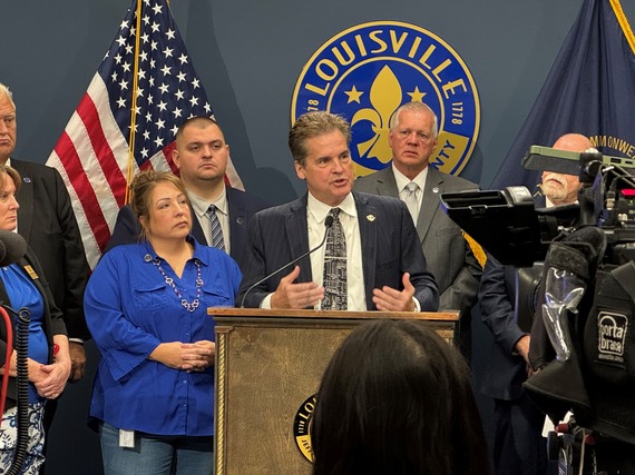
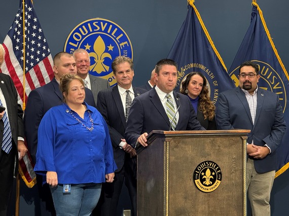 On Tuesday, September 9th the twelve Republican members of the Metro Council held a press event to outline more than a dozen legislative and policy proposals for improving safety within Louisville Metro.
Over the last year District 16 endured several break-ins both vehicle and home throughout the district. We worked closely with our 5th and 8th Division LMPD, who do a fantastic job, and even made several arrests. They need more support on the judicial level. I look forward to having more transparency through the construction of a scorecard for local decisions.-Councilman Scott Reed, District 16
Policies Addressed as part of the Safer Louisville Plan:
- Adding State police patrols on Jefferson County Interstate Roadways
- Eliminating streetside solicitation
- Funding a pilot program to place streetlights in 2 high crime areas.
- Cracking down on illegal ATV use
- Seeking a timely reopening of the Juvenile Justice Center
- Calling for the planning and development of a New Jail to improve worker and inmate safety.
- Funding programs to increase number of Traffic Feedback Signs, Flock Cameras and Real Time Video Cameras deployed within Metro.
- Supporting efforts to increase transparency and create a “scorecard” for better awareness on Judicial and Prosecutorial decisions especially involving violent criminals.
- Funding for construction of a new First Responder Training Facility
Minority Caucus Members also took a moment to recognize that September is Law Enforcement Appreciation Month. The special recognition was started in 2023 through a resolution establishing the month that was passed by a unanimous vote of the Louisville Metro Council.
“We owe so much to the officers who serve us and put their lives on the line to make our community safer. Law Enforcement Appreciation Month was established to help raise awareness by encouraging residents of businesses within Louisville Metro to take a moment to show their appreciation through acts of kindness and words of encouragement.” – Councilman Dan Seum, District 13
Progress on these policies will take time. To help keep you informed, I plan to give regular updates through this newsletter on a quarterly basis. A complete copy of the policy proposals discussed as part of the Minority Caucus’ Safer Louisville Plan can be found at https://louisvilleky.gov/government/metro-council-district-16.
 Senator Paul and Congressman Massie will make an official stop in Oldham County to give a Washington Update. Event details are: Thursday, September 25th at 10 am ET at the John Black Community Center, 1551, Hwy 393, LaGrange, KY 40031.
Please reply via email to Whitney_meadows@paul.senate.gov if you would like to attend.
Join Mayor Craig Greenberg and Councilman Scott Reed as they honor Turners 175th Anniversary celebration and Oktoberfest. American Turners of Louisville, located at 3125 River Road is the oldest social club in Louisville. The celebration begins at 12:00pm on Saturday, September 27th.


Louisville Zoo is proud to announce the return of “Boo at the Zoo presented by Meijer”, celebrating 44 years of merry, not scary fun! Tickets are on sale now and available at louisvillezoo.org/boo. This beloved event is a Louisville tradition and will begin this year starting September 27 and running through October 30 (Thursday – Sunday nights).
Tickets are all-inclusive and include Boo at the Zoo admission, parking, Spooktacular Carousel, “not-so-itsy-bitsy” Spider House and the Headless Horseman of Sleepy Hollow attraction.
Tickets:
Tickets for “Boo at the Zoo presented by Meijer” are $13.75 for all non-members ages 3 and older and $7.25 for all members ages 3 and older. Children ages 2 and under are free and do not require a ticket.
Members and guests can purchase tickets online at louisvillezoo.org/boo, with their chosen date and arrival time. Ticket capacity is limited each night with popular nights expected to sell out quickly.
“Boo at the Zoo presented by Meijer” is a rain or shine event.
If you or anyone you know might be interested in applying, please scan the QR code below or contact Amanda Carpenter at 574-7016 or "amanda.carpenter@louisvilleky.gov" and start the process.
| Jefferson County |
|
| I-65 Central Corridor |
Information related to the I-65 Central Corridor project can be found online at i65centralcorridor.com.
|
U.S. 31E (Main Street)
*Main Remade – East Phase |
***Construction phasing details, including traffic impacts, are available online at: www.MainRemade.com
Traffic Impacts: Sidewalk and lane closures are possible.
Date/Time: Daily.
Project Limits: U.S. 31E (Main Street) between Wenzel Street and 2nd Street.
Type of Work: One-way to two-way conversion. In addition to the new two-way configuration, other improvements coming to the corridor include upgrades to crosswalks and intersections, a protected bike lane, dedicated left-turn lanes, and new traffic signals.
|
| Old Eastern Parkway |
Traffic Impacts: Closure of Old Eastern Parkway.
Date/Time: Beginning Tuesday, Sept. 2, through Monday, Nov. 3.
Project Limits: Old Eastern Parkway between S. Floyd Street and S. Brook Street.
Type of Work: Maintenance project of the U.S. 60A (Eastern Parkway) bridge over S. Floyd Street.
Other Details: Traffic impacts are not expected to occur on the Eastern Parkway bridge while work is underway. |
| I-64 East and West |
Traffic Impacts: Westbound traffic is currently shifted from the outside shoulder to the inside lanes of the newly constructed bridge.
Date/Time: Daily/nightly.
Project Limits: I-64 East and West at mile point 11.799, near Exit 10 (Cannons Lane) on I-64 West, and near Exit 12 to I-264 (Watterson Expressway) on I-64 East.
Type of Work: Bridge replacement project.
Other Details: Project announcement press release
|
| I-65 North |
Traffic Impacts: Closure of the left three lanes.
Date/Time: Beginning at 7 p.m. Friday, Sept. 26, through Sunday, Sept. 28, at noon.
Project Limits: I-65 North between mile points 126.3 and 127.09 (near KY 1065/Outer Loop).
Type of Work: Concrete slab repairs.
Other Details: The right lane of the I-65 North on-ramp from I-265 East and West will also be closed. The extended lane closures are necessary for contract crews to perform concrete slab repairs and to allow ample time for the concrete to cure. Motorists should heed signage, use caution, and plan ahead for travel delays. |
| I-65 South |
Traffic Impacts: Ramp closures.
Date/Time: Work has been POSTPONED. TBD on closures
Project Limits:
· I-65 South ramp to I-71 North
· I-65 South ramp to I-64 West
· I-65 South ramp to I-64 East
Type of Work: High friction surface treatment application.
Other Details: High friction surface treatments (HFST) are designed to enhance roadway safety by increasing pavement friction, especially in wet weather conditions, and also provides added protection for concrete surfaces. Motorists are encouraged to follow signed detours, allow extra travel time, and exercise caution when driving in the work zone. |
| I-65 South |
Traffic Impacts: Lane reduction and road closure.
Date/Time: Beginning Monday, Aug. 25, through December 2025.
Project Limits: I-65 South bridge at Exit 136C to Jefferson Street in downtown Louisville.
Type of work: Bridge maintenance project.
Other Details: During construction, the bridge will be reduced to a single 10-foot lane. Wide loads will not be permitted to use the ramp, and signage will be posted in advance to alert drivers of the restriction. In addition, South Floyd Street will be closed between East Jefferson Street and East Liberty Street. Drivers should follow the signed detour: East Liberty Street to South Jackson Street, left onto East Jefferson Street, and back to Liberty Street. Motorists are encouraged to plan ahead, follow posted signage, and use caution when driving through the work zone. |
| I-65 South (John F. Kennedy Memorial Bridge) |
Traffic Impacts: Closure of the right three lanes.
I-65 South (John F. Kennedy Memorial Bridge).
Type of Work: Expansion joint replacement project.
Other Details: The right three lanes and right shoulder of the bridge carrying I-65 South over the Ohio River will remain closed through the end of 2025 for ongoing construction activities. While lane closures span the entire length of the bridge, access to I-64 and I-71 will be maintained throughout the duration of the work.
*July 28, 2025 press release
*June 3, 2025 press release
*March 31, 2025 press release
*February 27, 2025 press release
|
| I-264/U.S. 42 (Brownsboro Road) Improvement Project |
*Traffic impacts available here.
|
| KY 841 (Gene Snyder Freeway) |
Traffic Impacts: Single lane closures are possible.
Date/Time: Beginning Sunday, Sept. 21, through Saturday, Sept. 27.
Daily – 9 a.m. to 3 p.m. | Nightly – 7 p.m. to 5 a.m.
Project Limits: KY 841 North and South (Gene Snyder Freeway), between mile points 35.0 and 37.7, near and through the East End Tunnel.
Type of Work: Routine maintenance of the roadway and East End Tunnel.
Other Details: Motorists should heed signage, use caution, and adjust commutes to accommodate lane closures. |
| KY 841 North & I-265 East (in Jeffersonville, IN) |
Traffic Impacts: Overnight closures of the East End Tunnel.
Date/Time:
I-265 East (closed beyond Exit 11/International Drive in Jeffersonville, Indiana)
- From 7 p.m. Sunday, Sept. 28, to 6 a.m. Monday, Sept. 29.
- From 7 p.m. Monday, Sept. 29, to 6 a.m. Tuesday, Sept. 30.
- From 7 p.m. Tuesday, Sept. 30, to 6 a.m. Wednesday, Oct. 1.
KY 841 North (Gene Snyder Freeway) (closed beyond Exit 37/Prospect (U.S. 42))
- From 7 p.m. Wednesday, Oct. 1, to 6 a.m. Thursday, Oct. 2.
- From 7 p.m. Thursday, Oct. 2, to 6 a.m. Friday, Oct. 3.
|
| KY 864 (Logan Street/Shelby Street) |
Traffic Impacts: Sidewalk and lane closures are possible.
Date/Time: Daily and nightly.
Project Limits: Between Goss Avenue and East Gray Street.
Type of Work: One-way to two-way conversion of the roadway.
Other Details: Major work has resumed, with full completion expected by the Spring of 2026.
*The traffic signals at Logan/Mary, Logan/Breckinridge, Logan/Oak, Shelby/Breckinridge were activated on Monday, Sept. 1. Motorists should use caution and adhere to the temporary traffic pattern. |
| KY 1819 (Billtown Road) |
Traffic Impacts: Lane closures and delays are possible.
Date/Time: Daily – 9 a.m. to 4 p.m.
Project Limits: Three sections of KY 1819 (Billtown Road):
- Easum Road through Mary Dell Lane
- Michael Edward Drive through Fairground Road
- Shady Acres Lane through Colonnades Place
Type of Work: Reconstruction of KY 1819 (Billtown Road) from north of Colonnades Place to south of Easum Road with new traffic signals, signal optimization, turn lanes, storage lanes, etc. (varying by intersection based on existing conditions and future traffic projections).
Other Details: The reconstruction project is expected to be completed by the Fall of 2025.
*Project webpage
|
| KY 1934 North and South (Greenbelt Highway/Cane Run Road) |
Traffic Impacts: Closure of the left lane.
Date/Time: Beginning at 6 p.m. on Thursday, Sept. 18, through 11 a.m. on Saturday, Sept. 20.
Project Limits: KY 1934 North (Greenbelt Highway) from mile point 5.08 to mile point 7.87. The left lane of KY 1934 North will be closed between mile point 5.08 (near Intermodal Drive) and mile point 7.87 (near Lees Lane). Additionally, the left lane of KY 1934 South will be closed between mile point 5.19 (near Intermodal Drive) and mile point 6.48 (near Raggard Road) beginning at 7 p.m. on Tuesday, Sept. 23, through 11 a.m. on Thursday, Sept. 25.
Type of Work: Concrete slab repairs.
Other Details: The extended lane closure is necessary to allow ample time for the concrete to cure. Motorists should heed signage, use caution, and expect delays while traveling through the work zone. |
I-264
*Various Exit Ramps |
Traffic Impacts: Ramp narrowing with intermittent lane and shoulder closures.
Project Limits: Various interchange Exit ramps on I-64 and I-264.
Type of Work: Installation and upgrade of wrong-way pavement markings and signs.
Other Details: The Highway Safety Improvement Project will install and enhance wrong-way signs and pavement markings on interstate Exit ramps to discourage wrong-way driving. Motorists should reduce speeds and obey traffic control while workers are present. This project is expected to be completed by the Fall of 2025. |
| |
|
| Bullitt County |
|
| KY 61 (South Preston Highway) |
Traffic Impacts: Closure.
Date/Time: From 9 a.m. to 3 p.m. on Wednesday, Sept. 24.
Project Limits: KY 61 (South Preston Highway) between mile points 3.5 and 4.0 (near Collings Hill Road).
Type of Work: Slide repair.
Other Details: Motorists should plan to detour around the affected area while work is underway. |
| I-65/KY 480 (Cedar Grove Road) |
Traffic Impacts: Changing traffic patterns, lane shifts, and lane closures are possible as final construction activities are underway.
Date/Time: Daily and nightly.
Project Limits: KY 480 (Cedar Grove Road) between I-65 (mile points 0.6 and 1.4).
Type of Work: Reconstruction of the KY 480/I-65 interchange, including the construction of a double crossover diamond.
Other Details: The interchange reconstruction project is now in its final configuration. The project is expected to be completed by the Fall of 2025.
|
| |
|
| Franklin County |
|
| KY 12 (Flat Creek Road) |
Traffic Impacts: N/A.
Date/Time: Beginning Aug. 11, through Dec. 1.
Project Limits: KY 12 bridge over Flat Creek at mile point 12.46 (at the Franklin/Henry County line).
Type of Work: Bridge replacement project.
Other Details: Traffic will be maintained on the existing bridge until construction has been completed on the replacement bridge. |
| KY 12 (Flat Creek Road) |
Traffic Impacts: Road closure.
Date/Time: Beginning at 6 a.m. on Monday, Oct. 6, through 7 p.m. on Wednesday, Oct. 8.
Project Limits: KY 12 (Flat Creek Road) between mile points 11.4 and 12.4.
Type of Work: Cross drain replacement.
Other Details: Motorists should follow the posted detour around the affected area while work is underway. |
| I-64 East and West |
Traffic Impacts: Lane closures and traffic shifts are possible.
Date/Time: Daily/nightly beginning Thursday, Sept. 4.
Project Limits: The I-64 East and West, between the Frankfort exits (mile markers 53 and 58).
Type of Work: The I-64 improvement project, between the Frankfort exits (mile markers 53 and 58), includes the milling and removal of the existing asphalt surface followed by resurfacing with new asphalt pavement. Other improvements to the 5-mile corridor include bridge repairs and bridge crash wall repairs.
Other Details:
- Westbound I-64:
- Beginning Thursday, Sept. 4, at 7 p.m., through Sunday, Sept. 14, the left lane of I-64 West near U.S. 60 at mile marker 57 will be closed.
- Beginning Sunday, Sept. 14, at 7 a.m., through Wednesday, Sept. 24, the right lane of I-64 West near U.S. 60 at mile marker 57 will be closed.
- Eastbound I-64:
- Beginning Wednesday, Sept. 24, at 7 p.m., through Saturday, Oct. 4, the left lane of I-64 East near U.S. 60 at mile marker 57 will be closed.
- Beginning Saturday, Oct. 4, at 7 p.m., through Tuesday, Oct. 14, the right lane of I-64 East near U.S. 60 at mile marker 57 will be closed.
- U.S. 60 (Versailles Road):
- U.S. 60 (Versailles Road) will be reduced to one lane in each direction under the I-64 overpass bridge nightly from 9 p.m. to 6 a.m. beginning Monday, Sept. 15.
|
| U.S. 127/Vandalay Drive Intersection |
Traffic Impacts: Lane closures and traffic shifts are possible.
Date/Time: Daily/nightly.
Project Limits: U.S. 127/Vandalay Drive intersection.
Type of Work: The scope of the project includes constructing a new roundabout at the intersection of Vandalay Drive and Westridge Drive; extending Vandalay Drive to Limestone Drive to create a direct connection to KY 676 (East-West Connector); extending Vandalay Drive to U.S. 127 near the I-64/U.S. 127 interchange; and adding dual receiving lanes to improve left-turn movements from U.S. 127 onto Westridge Drive.
Other Details: The project is scheduled to be completed by the summer of 2026. |
| |
|
| Oldham County |
*Routine Maintenance* |
| |
|
| Spencer County |
*Routine Maintenance* |
| |
|
| Shelby County |
|
| I-64 Widening and Improvement Project |
*Traffic impacts here.
|
| KY 395 (Waddy Road) |
Traffic Impacts: Road closure.
Date/Time: Daily from 7 a.m. to 4 p.m. beginning Wednesday, Sept. 10, through Friday, Sept. 19.
Project Limits: KY 395 (Waddy Road) from mile point 3.4 (near Pea Ridge Road) to mile point 5.2 (near Scott Pike).
Type of Work: Roadway slide repair.
Other Details: Motorists should expect to follow the signed detours around the affected area while work is underway. |
| |
|
| Henry County |
*Routine maintenance* |
| |
|
| Trimble County |
*Routine maintenance* |
2025 Resurfacing Projects
Resurfacing projects will begin April 1, 2025, and will be completed by the Fall of 2025.
Motorists should heed signage and use caution when traveling through the work zone.
| County / Road Name: |
Project Limits: |
| Jefferson County |
|
| U.S. 60 (Shelbyville Road) |
Begin at an asphalt joint west of U.S. 60A extending east to 53 ft west of Sherburn Ln Spur Conn/Ten Pin Ln, a distance of 01.85 miles |
| U.S. 60 (Shelbyville Road) |
Begin at Urton Lane/North English Station Road, extending east to an asphalt joint 0.038 miles west of Beckley Woods Drive/English State Way. |
U.S. 31 (West Main Street)
|
West Main St (US 31W southbound only) begins at US 150/West Main St, extending south to 145 ft north of US 31, a distance of 1.78 miles. |
| KY 907 (Valley Station Road/Third Street Road) |
Begin at U.S. 31E extending north to Arnoldtown Road, a distance of 3.99 miles |
| KY 1065 (Outer Loop) |
Begin at KY 907 extending east to a concrete joint at KY 1020, a distance of 02.48 miles |
| KY 61 (Preston Highway) |
Begin at the north end of the bridge over I-265 extending north to 0.026 miles south of Okolona Ter, a distance of 01.86 miles |
KY 1230 (Lower River Road)
|
From Tennis Blvd, west 0.093 miles, extending northerly to KY 1934, a distance of 2.62 miles. |
KY 2830 (Arthur Street)
*Completed* |
KY 2830 (Arthur Street) east of Brandies Avenue/KY 61 extending north to University Boulevard. |
U.S. 31E (Bardstown Road)
*Completed* |
U.S. 31E (Bardstown Road) at the Bullitt/Jefferson County line, extending south of Colonel Hancock Drive. |
KY 1631 (Crittenden Drive)
*Completed* |
KY 1631 (Crittenden Drive) at the beginning of state maintenance near the I-264 interchange, extending north to U.S. 60A (Eastern Parkway). |
KY 1531 (Johnson Road)
*Completed* |
KY 1531 (Johnson Road) from the railroad crossing extending north to Aiken Road. |
KY 61 (Arthur Street)
*Completed* |
KY 61 (Arthur Street) beginning east of Brandies Avenue extending north to I-65 ramp/East Gaulbert Avenue. |
KY 155 (Taylorsville Road)
*Completed* |
KY 155 (Taylorsville Road) beginning at KY 1747 (Hurstbourne Lane) extending north to KY 1932 (Breckenridge Lane). |
KY 329 (Covered Bridge Road)
*Completed* |
KY 329 (Covered Bridge Road) beginning at U.S. 42 extending east to the Jefferson/Oldham County line. |
| |
|
| Bullitt County |
|
KY 61 (Old Preston Highway)
|
Begin at KY 61 extending north to 0.165 miles north Hillsbrook Dr, a distance of 0.87 miles
|
KY 61 (North Preston Highway)
|
Begin 21 ft north of KY 2553 extending north to Bullitt/Jefferson County line, a distance of 01.58 miles
|
| KY 480 (Cedar Grove Road) |
Begin 0.113 miles east of Park Loop Rd/Valley Vw Dr extending east to 0.077 miles east of KY 1442, a distance of 0.42 miles |
KY 1442 (Ridge Road)
|
Ridge Rd/Clarks Ln from McCubbins Farm Ln, south 0.056 mile, extending easterly towards Paddock Rd, a distance of 4.90 miles. |
KY 1604 (Deatsville Road)
|
From KY 245, extending northerly towards Jackson Hollow Rd, a distance of 3.20 miles. |
KY 1531 (Dawson Hill Road)
*Completed* |
KY 1531 (Dawson Hill Road) from KY 1319 extending north to the Bullitt/Jefferson County line. |
KY 2672 (Knob Creek Road)
*Completed* |
KY 2672 (Knob Creek Road) from KY 1526 (Brooks Hill Road) extending north towards Lake Elmo Road. |
KY 2674 (Stringer Lane)
*Completed* |
KY 2674 (Stringer Lane) from U.S. 31E extending north to KY 44. |
| |
|
| Franklin County |
|
| U.S. 60 (Louisville Road) |
Begin at the east end of Benson Creek Bridge extending east to mile point .025 just east of Office Park Drive. |
| KY 12 (Dry Ridge Road/Flat Creek Road) |
KY 12 (Dry Ridge Road/Flat Creek Road) from the Shelby/Franklin County line extending east to Harvieland Road. |
| KY 1570 (St Johns Road) |
KY 1570 (St Johns Road) from the bridge at mile point 4.2, extending north to KY 12. |
| U.S. 127 (Wilkinson Boulevard) |
U.S. 127 (Wilkinson Boulevard) near Hall Street extending north to the south end of the U.S. 127/KY 2261 bridge. |
| |
|
| Oldham County |
|
| KY 53 (North First Avenue) |
Begin at KY 146 extending north to US 42 (MP 11.045), a distance of 03.99 miles |
KY 524 (Westport Road)
|
From US 42, extending northerly towards Smith Ln, a distance of 1 mile. |
KY 362 (Central Avenue)
*Completed* |
KY 362 (Central Avenue) from Rosswoods Drive extending south towards KY 146. |
KY 329 (Covered Bridge Road)
*Completed* |
KY 329 (Covered Bridge Road) from KY 329B extending east to mile point 8.754. |
| KY 393 (Crestwood to La Grange) |
Begin at KY 22 extending north to the south end of the North Fork Bridge, a distance of 1.99 miles |
KY 393 (Payton Lane)
|
From KY 1818, extending northerly to KY 22, a distance of 2.56 miles. |
KY 1694 (Gum Street)
*Completed* |
KY 1694 (Gum Street) from KY 329 extending north towards Mason Lane. |
KY 3223 (Old Sligo Road)
|
From KY 53, extending northerly to Ballard School Rd, a distance of 1.55 miles. |
U.S. 42
*Completed* |
U.S. 42 east of KY 1694 (Gum Street) extending east to the Oldham/Henry County line. |
| |
|
| Shelby County |
|
U.S.421 (Castle Highway)
|
Begin 21 feet north of KY 3322 extending north to KY 55, a distance of 2.82 miles. Castle Highway begins at Henry/Shelby County line extending north to the Shelby/Henry County line, a distance of 0.79 mile. |
KY 22 (Ballardsville Road)
|
Begin at Oldham/Henry County line extending east to KY 55, a distance of 7.02 miles |
KY 362 (Aiken Road)
*Completed* |
KY 362 (Aiken Road) from the Oldham/Shelby County line extending east near Webb Road. |
| U.S. 60 (Frankfort Road) |
U.S. 60 (Frankfort Road) beginning at KY 395 extending east to the Shelby/Franklin County line. |
KY 1408 (Loydsburg Road)
*Completed* |
KY 1408 (Loydsburg Road) from KY 362 extending west to the Shelby/Oldham County line. |
KY 322 (Lucas Road)
*Completed* |
KY 322 (Lucas Road) from KY 53 extending north to the Shelby/Henry County line. |
KY 53 (Mt. Eden Road)
*Completed* |
KY 53 (Mt. Eden Road) beginning at KY 714/KY 44 extending north to KY 1790 (Hooper Station Road). |
We now have a new way for you to map crime around you. Just click here and view our new interactive crime mapping tool for Division 5 & 8 or for each beat in Division 5 & 8. And save it in your favorites to view crime anytime it's updated daily. On the page is a Quickfind tool that allows you to put your address in and subscribe to crime trends, alerts and block watch reports for your police beat. Forward this email to your friends and family!
For further information on Councilman Scott Reed or District 16 please visit www.louisvilleky.gov/government/metro-council-district-16
You can also reach out directly by phone at 502.574.1116 or by email at scott.reed@louisvilleky.gov.
601 West Jefferson Street
Louisville, KY 40202
Having Trouble Viewing this eNewsletter? Click here to view it on the web.
|