|
LOUISVILLE, Ky. (Aug. 1, 2025) – The Kentucky Transportation Cabinet (KYTC) advises motorists of overnight closures of Interstate 264 East (Watterson Expressway) in Louisville beginning Monday, Aug. 4, as part of the $130 million improvement project of I-264 and U.S. 42 (Brownsboro Road).
Scheduled traffic impacts, including dates and times, are listed below. Beginning at 8 p.m. Monday, Aug. 4, to 6 a.m. Tuesday, Aug. 5:
-
I-264 East traffic will be diverted via the U.S. 42 (Brownsboro Road) off-ramp at Exit 22. Drivers will cross U.S. 42 (Brownsboro Road) and rejoin I-264 East via the on-ramp located on the opposite side of the existing interchange.
Beginning at 8 p.m. Tuesday, Aug. 5, to 6 a.m. Wednesday, Aug. 6:
-
I-264 East traffic will be diverted via the U.S. 42 (Brownsboro Road) off-ramp at Exit 22. Drivers will cross U.S. 42 (Brownsboro Road) and rejoin I-264 East via the on-ramp located on the opposite side of the existing interchange.
Motorists should use caution, heed signage, and allow extra travel time during the scheduled closures. The highway improvement project is expected to be completed by the Fall of 2027. More details, including project timelines and traffic impacts, will be shared online as work progresses. Motorists are encouraged to sign up for email alerts regarding weekly traffic impacts pertaining to the project.
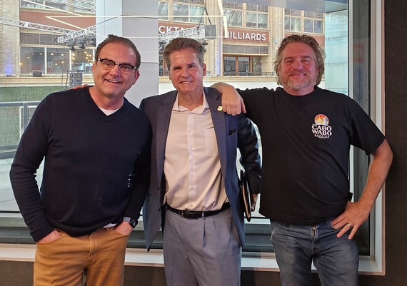 Greetings,
This morning, I had the privilege of joining Tony Vanetti and Dwight Witten to discuss the Louisville Water Company’s Residual Line project on River Road. I encourage everyone to get out and help support the great restaurants and businesses on River Road. During the ongoing construction it is still possible to access your favorite restaurants and businesses!
Thanks to Dwight and Tony for allowing me to advocate on behalf of District 16 businesses.
-Scott
Use this link: https://whas.iheart.com/featured/tony-dwight/tab/podcasts/ to listen to Councilman Reed’s full interview. Select episode: 8.1: Weekend Events Around Town, Councilman Scott Reed, and Progress on River Road. The Councilman’s segment starts around the 18:50 mark.
 Next Monday August 4 crews are scheduled to start work on Transylvania Avenue. They will start near River Road and move toward the end of the road. Customers will always have access to their homes and there should not be any disruption of water service. During construction residents will be asked to use the temporary road that has been constructed between the end of Mason Boulevard and Mayfair Avenue. The work is expected to last approximately one month. Once completed, Transylvania Avenue will be completely repaved, and the temporary road will be removed and the area restored with seed and straw.
LOUISVILLE, Ky. (Aug. 1, 2025) – The Kentucky Transportation Cabinet (KYTC) advises motorists of upcoming lane closures on Interstate 71 South on Monday, Aug. 4, in Oldham County.
Alternating lane closures will occur on I-71 South near mile point 11.8, at the bridge over Moser Farm Road, from 9 a.m. to 3 p.m. on Monday, Aug. 4. The lane closures are necessary for KYTC crews to perform bridge maintenance. Motorists should heed signage, use caution, and expect delays while traveling through the work zone.
 The Metro Council met Thursday for its first meeting since the passage of the FY26 Operating and Capital Budgets. The meeting addressed a number of zoning cases, grants to non-profit groups, appointments, as well as an effort to address criminal activities related to illegal dumping and the efforts to better prosecute those persons who steal metals and wiring from public utilities and private property.
Meeting /Highlights
Special Recognition: Councilman Jonathan Joseph and members of the Metro Council recognized the outstanding achievements of Butler Traditional High School student, Jorge Blas Bautista for being recognized as a Gates Scholar.
Scrap Metal Ordinance: The Metro Council passed an update to our ordinances addressing stolen metals. The ordinance, that was sponsored by Councilman Kevin Kramer (District 11) increases fines as well as adds language to assist police as they seek to prosecute persons who destroy the property of others removing metals from sources that we all need and use such as light poles, HVAC Units, vehicles or other properties. The ordinance was created, working with the second hands metal industry, as well as police and utility companies who each are greatly affected by criminal actions that lead to the striping of materials from infrastructure and private property.
Illegal Dumping (O-087025) : The Metro Council has previously passed ordinances meant to assist police in citing those persons who are caught dumping materials in public spaces. The previously passed ordinance allowed police to tow and hold vehicles involved in illeagel dumping for 3 days (first offense) and up to 90 days (third offense). The ordinance passed at the July 31, 2025 meeting helps to draw additional attention to those persons who fail to secure their loads and those who aren’t sanctioned for junk hauling. This ordinance also increases the fines from $500 to $1000 for the first offense and increases the fine for each subsequent offense. These ordinances as well as continued investments by Louisville Metro in cameras in targeted areas have led to the towing and citation of approximately 100 persons in the past year and hopefully will continue to help us make progress in making our community cleaner and more safe.
Grants: Funding to support a number of non-profit orgnaizations were approved at the Metro Council Meeting. Grants were passed supporting Coalition for the Homeless, the upcoming Fairdale Fair and Family Scholar House each received unanimous approval.
Zoning Cases
Aiken Road Proposed Development: The Metro Council voted to approve a changes to a previously approved zoning case located on Aiken Road (O-107-25). This case was amended to add binding elements to improve infrastructure on property near the proposed land and will help improve issues related to traffic in the area as well as new enhancements to public spaces within the development.
Broad Run Road Denial: The Metro Council voted to approve a finding of fact proposed by Councilman Kevin Bratcher (District 22) that denied the request for a zoning change for property located at 8000 Broad Run Road.
Next week will be a committee week for members of the Metro Council. The Next Meeting of the Louisville Metro Council will be on Thursday, August 14th.

 Hello, neighbor!
The Louisville Metro Office of Planning is
gathering information about possible uses for
land along River Road and we'd like to hear from
you. Please come to a neighborhood meeting to
learn more, or scan the QR code below to
complete our survey. This is not a Louisville
Loop Project.
Date: August 13,2025
Time: 6:00-8:00 pm
Place: Locust Grove-Gallery, 561 Blankenbaker Ln.
Questions or comments?
(502) 574-6230 or
communityplanning@louisvilleky.gov
LOUISVILLE, Ky. (July 29, 2025) – The Louisville Zoo has partnered with Meijer for a backpack collection drive to benefit the Boys and Girls Club of Kentuckiana. Guests are encouraged to bring and donate a new backpack on their trip to the Zoo between July 30- Aug.13 and receive $5 off general admission. Donated backpacks can be placed in a marked box at the Zoo’s entrance.
"On behalf of Meijer, we’re proud to partner with the Louisville Zoo’s backpack drive all to support the Boys & Girls Club of Kentuckiana. It’s always exciting to come together with these two wonderful organizations for a cause that helps kids start the school year confident and prepared.” Alyssa Upton, Louisville/Lexington Market Director.
The discount is available at Zoo ticketing windows only and is not valid for online purchases. Parking is not included. The offer excludes special fee-based programs, reciprocal discounts, prepaid groups, field trips, special events or in combination with any other discounts. Refunds will not be issued for tickets purchased in advance or online.
***
The Louisville Zoo, the State Zoo of Kentucky, is the top, non-profit, paid attraction in the state. The Zoo is dedicated to bettering the bond between people and our planet by providing excellent care for animals, a great experience for visitors, and leadership in scientific research and conservation education. The Zoo is accredited by the Association of Zoos and Aquariums (AZA) and is a member of the World Association of Zoos and Aquariums (WAZA), a global alliance of zoos and aquariums.
# # #
 

|
Join us at Locust Grove for an unforgettable evening of live music! This concert features Latin & Bluegrass music from Appalatin.
Appalatin's foot-stomping, hip-swinging sounds unite Appalachian folk & high-energy Latin music, reflecting the fusion of Kentuckians & Latin émigrés from Ecuador, Nicaragua, and Guatemala.
Beverages and snacks are available to purchase – no outside food please, but feel free to bring your own lawn chairs or seating. Doors open at 6PM.
This LouGrass concert is made possible by our Bravo Sponsor, Louisville Tourism.
|
|
|
New items or changes in project status are shown in bold
Inclement weather or other unforeseen circumstances may arise, and as such, the information provided below is for advisory purposes only and subject to change without prior notice.
| Jefferson County |
|
U.S. 31E (Main Street)
*Main Remade – East Phase |
Traffic Impacts: Sidewalk and lane closures are possible.
Date/Time: Daily.
Project Limits: U.S. 31E (Main Street) between Wenzel Street and 2nd Street.
Type of Work: One-way to two-way conversion. In addition to the new two-way configuration, other improvements coming to the corridor include upgrades to crosswalks and intersections, a protected bike lane, dedicated left-turn lanes, and new traffic signals.
***Construction phasing details are available online at: www.MainRemade.com
|
| I-64 East and West |
Traffic Impacts: Lane closures and traffic shifts are possible.
Date/Time: Daily and nightly.
Project Limits: I-64 East and West at mile point 11.799, near Exit 10 (Cannons Lane) on I-64 West, and near Exit 12 to I-264 (Watterson Expressway) on I-64 East.
Type of Work: Bridge replacement project.
Other Details: **Eastbound and westbound traffic is shifted to the outer shoulders. Construction is currently taking place in the median, and two 11-foot lanes will remain open in each direction for the duration of the project.
*Press release
|
| I-65 South (John F. Kennedy Memorial Bridge) |
Traffic Impacts: Closure of the right three lanes.
Project Limits: I-65 South (John F. Kennedy Memorial Bridge).
Type of Work: Expansion joint replacement project.
Other Details: The right three lanes and right shoulder of the bridge carrying I-65 South over the Ohio River will remain closed through the end of 2025 for ongoing construction activities. While lane closures span the entire length of the bridge, access to I-64 and I-71 will be maintained throughout the duration of the work.
*July 28, 2025 press release
*June 3, 2025 press release
*March 31, 2025 press release
*February 27, 2025 press release
|
| I-65 North |
Traffic Impacts: Lane and ramp closures.
Details: Beginning at 8 p.m. on Friday, Aug. 1, the center and right lanes of I-65 North will close at mile marker 135 (near U.S. 150/East Broadway). In addition, the northbound off-ramp to Brook Street at Exit 136A will also be closed. These lane and ramp closures will remain in place through 5 a.m. on Monday, Aug. 4. Motorists should heed signage, use caution, and expect delays when traveling through the work zone.
Additional information is available here.
|
| I-264/U.S. 42 (Brownsboro Road) Improvement Project |
*Traffic impacts here.
|
| I-265 West (Gene Snyder Freeway) |
Traffic Impacts: Lane and ramp closures.
Date/Time: Beginning at 7 p.m. on Friday, Aug. 1, through 5 a.m. on Monday, Aug. 3.
Project Limits: The left lane of I-265 West (Gene Snyder Freeway) at the bridge over U.S. 31E and the I-265 West on-ramp from U.S. 31E (Bardstown Road).
Type of Work: Bridge expansion joint replacement.
Other Details: Motorists should heed signage, use caution, and plan for extended travel times. |
| KY 841 (Gene Snyder Freeway) |
Traffic Impacts: Single lane closures are possible.
Date/Time: Beginning Sunday, Aug. 3, through Saturday, Aug. 9.
Daily – 9 a.m. to 3 p.m. | Nightly – 7 p.m. to 5 a.m.
Project Limits: KY 841 North and South (Gene Snyder Freeway), between mile points 35.0 and 37.7, near and through the East End Tunnel.
Type of Work: Routine maintenance of the roadway and East End Tunnel.
Other Details: Motorists should heed signage, use caution, and adjust commutes to accommodate lane closures. |
| KY 864 (Logan Street/Shelby Street) |
Traffic Impacts: Sidewalk and lane closures are possible.
Date/Time: Daily and nightly.
Project Limits: Between Goss Avenue and East Gray Street.
Type of Work: One-way to two-way conversion of the roadway.
Other Details: Major work has resumed, with full completion expected by the Spring of 2026.
*The traffic signals at Logan/Mary, Logan/Breckinridge, Logan/Oak, Shelby/Breckinridge are currently set to flash for STOP conditions. On Sept. 1, 2025, the signals are scheduled to be activated. Motorists should use caution and adhere to the temporary traffic pattern. |
| KY 1819 (Billtown Road) |
Traffic Impacts: Lane closures and delays are possible.
Date/Time: Daily – 9 a.m. to 4 p.m.
Project Limits: Three sections of KY 1819 (Billtown Road):
- Easum Road through Mary Dell Lane
- Michael Edward Drive through Fairground Road
- Shady Acres Lane through Colonnades Place
Type of Work: Reconstruction of KY 1819 (Billtown Road) from north of Colonnades Place to south of Easum Road with new traffic signals, signal optimization, turn lanes, storage lanes, etc. (varying by intersection based on existing conditions and future traffic projections).
Other Details: The reconstruction project is expected to be completed by the Summer of 2025.
*Project webpage
|
I-64 and I-264
*Various Exit Ramps |
Traffic Impacts: Ramp narrowing with intermittent lane and shoulder closures.
Project Limits: Various interchange Exit ramps on I-64 and I-264.
Type of Work: Installation and upgrade of wrong-way pavement markings and signs.
Other Details: The Highway Safety Improvement Project will install and enhance wrong-way signs and pavement markings on interstate Exit ramps to discourage wrong-way driving. Motorists should reduce speeds and obey traffic control while workers are present. This project is expected to be completed by the Fall of 2025. |
| *Various Locations |
Traffic Impacts: Lane closures and delays are possible as part of a mobile operation.
Date/Time: Nightly – 8 p.m. to 5 a.m.
Type of Work: Pavement striping.
Other Details: Motorists should provide plenty of space to crews displaying "WET PAINT" signage and be observant of slowed vehicles while traveling through the work zone. |
| |
|
| Bullitt County |
|
| I-65/KY 480 (Cedar Grove Road) |
Traffic Impacts: Changing traffic patterns, lane shifts, and lane closures are possible as final construction activities are underway.
Date/Time: Daily and nightly.
Project Limits: KY 480 (Cedar Grove Road) between I-65 (mile points 0.6 and 1.4).
Type of Work: Reconstruction of the KY 480/I-65 interchange, including the construction of a double crossover diamond.
Other Details: The interchange reconstruction project is now in its final configuration. The project is expected to be completed by the Fall of 2025.
|
| *Various Locations |
Traffic Impacts: Lane closures and delays are possible as part of a mobile operation.
Date/Time: Daily – 7 a.m. to 11 p.m.
Type of Work: Pavement striping.
Other Details: Motorists should provide plenty of space to crews displaying "WET PAINT" signage and be observant of slowed vehicles while traveling through the work zone. |
| |
|
| Franklin County |
|
| U.S. 60 (Louisville Road) |
Traffic Impacts: Lane closures are possible.
Date/Time: Daily.
Project Limits: U.S. 60 (Louisville Road) from mile point .023 to mile point 3.89.
Type of Work: Base failure repairs ahead of an upcoming asphalt resurfacing project.
Other Details: Motorists should heed signage, use caution, and expect delays. |
| U.S. 127/Vandalay Drive Intersection |
Traffic Impacts: Lane closures and traffic shifts are possible.
Date/Time: Daily/nightly.
Project Limits: U.S. 127/Vandalay Drive intersection.
Type of Work: The scope of the project includes constructing a new roundabout at the intersection of Vandalay Drive and Westridge Drive; extending Vandalay Drive to Limestone Drive to create a direct connection to KY 676 (East-West Connector); extending Vandalay Drive to U.S. 127 near the I-64/U.S. 127 interchange; and adding dual receiving lanes to improve left-turn movements from U.S. 127 onto Westridge Drive.
Other Details: The project is scheduled to be completed by the summer of 2026. |
| KY 1665 (Bridgeport-Benson Road) |
Traffic Impacts: Closure.
Date/Time: Beginning Monday, July 7, through Sunday, September 7.
Project Limits: KY 1665 (Bridgeport-Benson Road) bridge over South Benson Creek at mile point 3.93.
Type of Work: Bridge replacement. |
| |
|
| Oldham County |
|
| I-71 South |
Traffic Impacts: Alternating lane closures.
Date/Time: From 9 a.m. to 3 p.m. on Monday, Aug. 4.
Project Limits: I-71 South at mile point 11.8 at the bridge over Moser Farm Road.
Type of Work: Bridge maintenance.
Other Details: Motorists should heed signage, use caution, and expect delays. |
| *Various Locations |
Traffic Impacts: Lane closures and delays are possible as part of a mobile operation.
Date/Time: Daily – 7 a.m. to 11 p.m.
Type of Work: Pavement striping.
Other Details: Motorists should provide plenty of space to crews displaying "WET PAINT" signage and be observant of slowed vehicles while traveling through the work zone. |
| |
|
| Spencer County |
*Routine maintenance* |
| |
|
| Shelby County |
|
| I-64 Widening and Improvement Project |
*Traffic impacts here.
|
| U.S. 60 (Frankfort Road) |
Traffic Impacts: Lane closures are possible.
Date/Time: Daily.
Project Limits: U.S. 60 (Frankfort Road) from mile point 19.338 at KY 395 to mile point 23.0 at the Franklin/Shelby County line.
Type of Work: Base failure repairs ahead of an upcoming asphalt resurfacing project.
Other Details: Motorists should heed signage, use caution, and expect delays. |
| *Various Locations |
Traffic Impacts: Lane closures and delays are possible as part of a mobile operation.
Date/Time: Daily – 7 a.m. to 11 p.m.
Type of Work: Pavement striping.
Other Details: Motorists should provide plenty of space to crews displaying "WET PAINT" signage and be observant of slowed vehicles while traveling through the work zone. |
| |
|
| Henry County |
*Routine maintenance* |
| |
|
| Trimble County |
*Routine maintenance* |
| 2025 Resurfacing Projects |
*Resurfacing projects will begin on or after April 1, 2025, and will be completed by the Fall of 2025. Motorists should heed signage and use caution when traveling through the work zone.* |
| |
|
| Jefferson County |
|
| U.S. 60 (Shelbyville Road) |
Project Limits:
Begin at an asphalt joint west of US 60A extending east to 53 ft west of Sherburn Ln Spur Conn/Ten Pin Ln, a distance of 01.85 miles |
| U.S. 60 (Shelbyville Road) |
Project Limits:
Begin at Urton Ln/N English Station Rd extending east to an asphalt joint 0.038 miles west of Beckley Woods Dr/English State Way, a distance of 0.56 miles |
| KY 907 (Valley Station Road) |
Project Limits:
Begin at US 31E extending north to Arnoldtown Road, a distance of 3.99 miles |
| KY 1065 (Outer Loop) |
Project Limits:
Begin at KY 907 extending east to a concrete joint at KY 1020, a distance of 02.48 miles |
| KY 61 (Preston Highway) |
Project Limits:
Begin at the north end of the bridge over I-265 extending north to 0.026 miles south of Okolona Ter, a distance of 01.86 miles |
KY 2830 (Arthur Street)
*Completed* |
Project Limits:
KY 2830 (Arthur Street) east of Brandies Avenue/KY 61 extending north to University Boulevard. |
U.S. 31E (Bardstown Road)
*Completed* |
Project Limits:
U.S. 31E (Bardstown Road) at the Bullitt/Jefferson County line, extending south of Colonel Hancock Drive. |
KY 1631 (Crittenden Drive)
*Completed* |
Project Limits:
KY 1631 (Crittenden Drive) at the beginning of state maintenance near the I-264 interchange, extending north to U.S. 60A (Eastern Parkway). |
KY 1531 (Johnson Road)
*Completed* |
Project Limits:
KY 1531 (Johnson Road) from the railroad crossing extending north to Aiken Road. |
KY 61 (Arthur Street)
*Completed* |
Project Limits:
KY 61 (Arthur Street) beginning east of Brandies Avenue extending north to I-65 ramp/East Gaulbert Avenue. |
KY 155 (Taylorsville Road)
*Completed* |
Project Limits:
KY 155 (Taylorsville Road) beginning at KY 1747 (Hurstbourne Lane) extending north to KY 1932 (Breckenridge Lane). |
KY 329 (Covered Bridge Road)
*Completed* |
Project Limits:
KY 329 (Covered Bridge Road) beginning at U.S. 42 extending east to the Jefferson/Oldham County line. |
| |
|
| Bullitt County |
|
KY 61 (Old Preston Highway)
|
Project Limits:
Begin at KY 61 extending north to 0.165 miles north Hillsbrook Dr, a distance of 0.87 miles
|
KY 61 (North Preston Highway)
|
Project Limits:
Begin 21 ft north of KY 2553 extending north to Bullitt/Jefferson County line, a distance of 01.58 miles
|
| KY 480 (Cedar Grove Road) |
Project Limits:
Begin 0.113 miles east of Park Loop Rd/Valley Vw Dr extending east to 0.077 miles east of KY 1442, a distance of 0.42 miles |
KY 1531 (Dawson Hill Road)
*Completed* |
Project Limits:
KY 1531 (Dawson Hill Road) from KY 1319 extending north to the Bullitt/Jefferson County line. |
KY 2672 (Knob Creek Road)
*Completed* |
Project Limits:
KY 2672 (Knob Creek Road) from KY 1526 (Brooks Hill Road) extending north towards Lake Elmo Road. |
KY 2674 (Stringer Lane)
*Completed* |
Project Limits:
KY 2674 (Stringer Lane) from U.S. 31E extending north to KY 44. |
| |
|
| Franklin County |
|
| U.S. 60 (Louisville Road) |
Project Limits:
Begin at the east end of Benson Creek Bridge extending east to mile point .025 just east of Office Park Drive. |
| KY 12 (Dry Ridge Road/Flat Creek Road) |
Project Limits:
KY 12 (Dry Ridge Road/Flat Creek Road) from the Shelby/Franklin County line extending east to Harvieland Road. |
| KY 1570 (St Johns Road) |
Project Limits:
KY 1570 (St Johns Road) from the bridge at mile point 4.2, extending north to KY 12. |
| U.S. 127 (Wilkinson Boulevard) |
Project Limits:
U.S. 127 (Wilkinson Boulevard) near Hall Street extending north to the south end of the U.S. 127/KY 2261 bridge. |
| |
|
| Oldham County |
|
| KY 53 (North First Avenue) |
Project Limits:
Begin at KY 146 extending north to US 42 (MP 11.045), a distance of 03.99 miles |
KY 362 (Central Avenue)
*Completed* |
Project Limits:
KY 362 (Central Avenue) from Rosswoods Drive extending south towards KY 146. |
KY 329 (Covered Bridge Road)
*Completed* |
Project Limits:
KY 329 (Covered Bridge Road) from KY 329B extending east to mile point 8.754. |
| KY 393 (Crestwood to La Grange) |
Project Limits:
Begin at KY 22 extending north to the south end of the North Fork Bridge, a distance of 1.99 miles |
KY 1694 (Gum Street)
*Completed* |
Project Limits:
KY 1694 (Gum Street) from KY 329 extending north towards Mason Lane. |
U.S. 42
*Completed* |
Project Limits:
U.S. 42 east of KY 1694 (Gum Street) extending east to the Oldham/Henry County line. |
| |
|
| Shelby County |
|
KY 362 (Aiken Road)
*Completed* |
Project Limits:
KY 362 (Aiken Road) from the Oldham/Shelby County line extending east near Webb Road. |
| U.S. 60 (Frankfort Road) |
Project Limits:
U.S. 60 (Frankfort Road) beginning at KY 395 extending east to the Shelby/Franklin County line. |
KY 1408 (Loydsburg Road)
*Completed* |
Project Limits:
KY 1408 (Loydsburg Road) from KY 362 extending west to the Shelby/Oldham County line. |
KY 322 (Lucas Road)
*Completed* |
Project Limits:
KY 322 (Lucas Road) from KY 53 extending north to the Shelby/Henry County line. |
KY 53 (Mt. Eden Road)
*Completed* |
Project Limits:
KY 53 (Mt. Eden Road) beginning at KY 714/KY 44 extending north to KY 1790 (Hooper Station Road). |
| |
|
| Spencer County |
|
KY 1392 (Grays Run Road)
*Completed* |
Project Limits:
Begin at the east end of Simpsonville Creek Bridge extending east to KY 55, a distance of 2.64 miles |
KY 1633 (Elk Creek Road)
*Completed* |
Project Limits:
KY 1633 (Elk Creek Road) from KY 1135 (Industrial Road) extending north to KY 55.
|
KY 1795 (Mill Road)
*Completed* |
Project Limits:
KY 1795 (Mill Road) from Paradise Pointe Road extending east to KY 636. |
KY 55 (Shelbyville Road)
*Completed* |
Project Limits:
KY 55 (Shelbyville Road) beginning at KY 155 extending north to the Spencer/Shelby County line. |
| |
|
| Henry County |
|
U.S. 421 (Campbellsburg Road)
*Completed* |
Project Limits:
U.S. 421 (Campbellsburg Road) at the I-71 overpass extending to the Henry/Trimble County line. |
KY 1360 (Franklinton Road)
*Completed* |
Project Limits:
KY 1360 (Franklinton Road) from KY 22 extending north to Bullitt Hill Road.
|
KY 241 (Pleasureville Road)
*Completed* |
Project Limits:
KY 241 (Pleasureville Road) beginning at the Shelby/Henry County line extending north to U.S. 421. |
KY 1861 (Smithfield Road)
*Completed* |
Project Limits:
KY 1861 (Smithfield Road) from KY 22 extending to KY 322. |
| |
|
| Trimble County |
|
KY 1256 (Fisher Ridge Road)
*Completed* |
Project Limits:
KY 1256 (Fisher Ridge Road) from Detmer Lane extending east to KY 625. |
KY 3175 (Sulphur-Bedford Road)
*Completed* |
Project Limits:
KY 3175 (Sulphur-Bedford Road) from Hoskins Lane extending north to U.S. 42. |
We now have a new way for you to map crime around you. Just click here and view our new interactive crime mapping tool for Division 5 & 8 or for each beat in Division 5 & 8. And save it in your favorites to view crime anytime it's updated daily. On the page is a Quickfind tool that allows you to put your address in and subscribe to crime trends, alerts and block watch reports for your police beat. Forward this email to your friends and family!
For further information on Councilman Scott Reed or District 16 please visit www.louisvilleky.gov/government/metro-council-district-16
You can also reach out directly by phone at 502.574.1116 or by email at scott.reed@louisvilleky.gov.
601 West Jefferson Street
Louisville, KY 40202
Having Trouble Viewing this eNewsletter? Click here to view it on the web.
|


