Forecasting, capturing, and storing water in a warming climate
The California State Water Resources Control Board approved nine groundwater recharge permits just before the recent February storms, allowing nearly 43,000 acre-feet of water to be stored underground — enough for approximately 128,000 households annually. These approvals included two short-term (180-day) and seven longer-term (5-year) permits, marking a record number of multi-year approvals since the program began in 2020. The permits support projects across several Northern and Central California watersheds, helping agencies capture stormwater and replenish aquifers ahead of future droughts. This effort reflects California’s push to better store water during wet periods as climate extremes intensify. To learn more about nine approved groundwater recharge permit, see the full article on Maven’s Notebook.
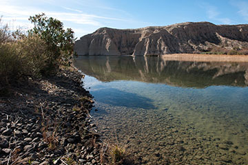
As DWR Director Karla Nemeth notes in an recent article for Maven’s Notebook, California water managers see March 2026 as a troubling repeat of 2021: low snowpack (about half of average), unusually warm temperatures, and the risk that expected snowmelt won’t make it into reservoirs because dry soils and warm air absorb it. Since 2021, DWR has improved its forecasting. New tools include short-term weather integration, advanced snow hydrology models (like iSnobal), aerial snow measurements, snow monitoring, soil moisture tracking, and a multi-source runoff dashboard. These advances help better predict how much water actually will become usable supply. Unfortunately, climate change is disrupting traditional patterns. Snow is melting earlier — 20% was already gone by March 1 — and runoff is happening sooner than reservoirs are designed to capture, as they must keep space for potential floods. California also lacks enough infrastructure to store or redirect this early water. The consequences are significant: less water later in summer, stress on rivers and ecosystems (especially fish such as salmon), and reduced reliability of water deliveries to farms and cities. The response requires caution and long-term adaptation: conservative water supply planning, habitat restoration, expanded storage (reservoirs and aquifers), and more efficient water use, recycling, and capture during storms.
|
Combining Flood-SVI and FIRO in California’s Central Valley
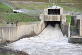
As detailed in the last month’s Central Valley Flood Protection Plan eNews, DWR is improving flood management in the Central Valley through two key initiatives: a flood-specific social vulnerability index (Flood-SVI) and forecast-informed reservoir operations (FIRO). The Flood-SVI is a data-driven tool designed to identify communities that are most vulnerable to flood impacts based on social, economic, and demographic factors (such as income, age, disability, and access to transportation). FIRO is an advanced approach to managing reservoirs using real-time data, weather forecasts, and hydrologic modeling. It allows water managers to make flexible decisions about when to store or release water, improving both flood protection and water supply reliability. This effort, led by DWR in collaboration with other agencies, represents a major step toward adapting California’s water system to climate change. Together, Flood-SVI and FIRO enhance California’s ability to manage flood risks more equitably and effectively by combining social vulnerability analysis with advanced, science-based water operations.
|
CUAHSI to host NEON webinar, April 1
The Consortium of Universities for the Advancement of Hydrologic Science, Inc. (CUAHSI) will host a webinar on Wednesday, April 1, that explores hydrologic data products published by the National Ecological Observatory Network (NEON) across observational, instrumented, and remote sensing subsystems. Titled “Introduction to NEON for Hydrology,” the webinar will be split into two parts. The first will cover how to download and explore different NEON hydrologic data products. The second takes a deeper look at these data by using co-located terrestrial and aquatic sites to study the water cycle across multiple scales. The two-hour webinar begins at 10 a.m. next Wednesday. Registration is open now.
|
Tribal Stewardship in California to expand by 7.5 million acres
The California Natural Resources Agency (CNRA) has introduced California’s first-ever Tribal Stewardship Policy, setting a goal to expand tribal stewardship to at least 7.5 million acres of land and coastal waters. The policy recognizes Native American tribes as the original stewards of these environments and emphasizes their expertise in managing natural resources. The policy aims to create lasting tribal–state partnerships by improving tribal access to ancestral lands, encouraging collaboration, and supporting the return of ancestral territories. This ancestral land return marks a major shift from past state policies that excluded tribes, dismissed Traditional Ecological Knowledge, and harmed both ecosystems and communities. The policy also addresses historical injustices, including the unratified 1852 treaties that would have granted tribes 7.5 million acres. As of 2026, California has returned approximately 103,000 acres to tribes and expanded cooperative agreements for access and stewardship across hundreds of thousands of acres. The policy is a historic step toward repairing relationships with tribes, restoring stewardship practices, and improving environmental health across California. For more information, read the full story about this landmark policy on the CRNA website. To learn about the Tribal Stewardship Policy and explore the Toolkit, visit CRNA’s Tribal Stewardship Policy & Toolkit webpage.
|
To subscribe to California Water Plan eNews, visit the DWR email subscription page and select the “California Water Plan eNews” option.
CALIFORNIA WATER PLAN | COMMENTS and SUGGESTIONS
Subscribe to the Save Our Water newsletter.
|