Creating a Flood-specific Social Vulnerability Index (Flood-SVI): Balancing the needs of all community members represented in the Central Valley Flood Protection Plan
Communities across California’s Central Valley face varying levels of flood risk not only due to physical exposure but also because of social, economic, and demographic factors that influence their ability to prepare for, respond to, and recover from flood events. Recognizing these disparities, the Department of Water Resources (DWR) has developed a flood-specific social vulnerability index (Flood-SVI) to better understand where flood impacts may have the most severe social impacts and to inform more equitable flood risk management planning.
|
A SVI evaluates a range of indicators—including income, age, housing characteristics, and transportation availability—to identify communities that may experience disproportionate impacts from flooding and related disasters. By providing a consistent, data-driven framework, SVIs help highlight areas where targeted engagement, resources, and investments may be most needed.
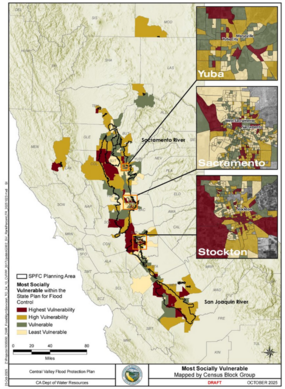
As part of the 2027 Central Valley Flood Protection Plan (CVFPP) Update, DWR developed a flood-focused SVI and companion mapping tool. This Flood-SVI uses specific demographic indicators to identify populations that are particularly vulnerable to flood impacts, such as children under five years of age and individuals without access to a vehicle. The Flood-SVI is being used to inform flood consequence and risk analyses for the 2027 CVFPP Update, helping ensure that technical evaluations better reflect community vulnerability.
In addition to supporting CVFPP technical analyses, the Flood-SVI serves as a practical tool for local agencies, helping inform flood planning, public outreach, and emergency response efforts. Demographic data were analyzed at the census block group level—the smallest geographic unit with reliable data—to provide DWR and its partners with a detailed, community-scale understanding of where vulnerable populations are located.
The companion mapping tool allows users to select individual census block groups and view which of the 15 SVI indicators are present, such as the proportion of residents over age 65 or individuals with disabilities. Together, the Flood-SVI and mapping tool enhance transparency, support equitable decision-making, and strengthen flood resilience planning in the Central Valley.
Strategic Water Management: Advancing Flood and Water Supply Resilience Through Forecast Informed Reservoir Operations (FIRO)
In support of integrated water and flood management objectives, the California DWR continues to advance Forecast-Informed Reservoir Operations (FIRO) as a strategic approach to improving flood risk management and water supply reliability under increasingly variable and extreme hydrologic conditions. FIRO leverages advanced weather forecasting, hydrologic modeling, and real-time monitoring to inform reservoir operations, enabling operators to make more flexible and informed decisions while maintaining public safety.
The upcoming updates to the Water Control Manuals for Lake Oroville and New Bullards Bar Reservoir represent a significant step toward enhancing regional resilience to extreme weather events by formally incorporating FIRO principles into reservoir operations. By incorporating FIRO principles, water managers will be better equipped to determine when to store or release water based on forecasted conditions rather than relying solely on historical hydrology.
A recent draft viability assessment confirmed that FIRO can deliver key benefits, including:
- Reducing flood risk: Improved forecasts of large atmospheric river storms allow operators to make coordinated, early releases that create additional flood control capacity and reduce pressure on downstream levees.
- Improving water supply reliability: Increased operational flexibility enables more water to be safely retained during dry periods, strengthening drought resilience for communities, agriculture, and the environment.
Incorporating FIRO strategies into official Water Control Manuals provides the legal authorization for dam operators to use the best available science and technology, moving beyond outdated procedures that depend on historical conditions. This effort represents a first-in-the-state implementation of FIRO that coordinates the operations of two major reservoirs, Lake Oroville and New Bullards Bar, to manage flood flows at a single downstream control point near Marysville and Yuba City.
This collaborative effort is led by DWR, operator of Lake Oroville; Yuba Water Agency, operator of New Bullards Bar; and the U.S. Army Corps of Engineers (USACE). USACE serves as the federal authority overseeing flood management operations and is responsible for approving updates to the Water Control Manuals.
The successful application of FIRO at Lake Oroville and New Bullards Bar will be a key component of the 2027 CVFPP Update, supporting adaptation of California’s statewide water management system to a changing climate.
Upcoming Meetings
-
February 27 | 9 am – 12 pm Central Valley Flood Protection Board Meeting
|