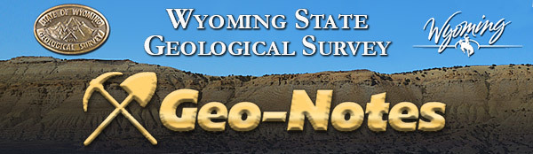
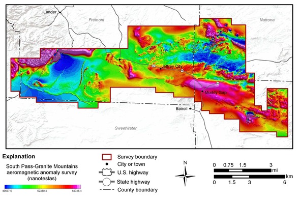
 Residents and travelers in central Wyoming may recall seeing low-flying helicopters in the greater South Pass-Granite Mountains region during much of last summer. The helicopters, contracted with New Sense Geophysics Ltd. and Merrick-Surdex Joint Venture, appeared to be flying lower to the ground than usual. The helicopters flew back and forth in a pattern spaced about 650 feet apart and about 300 feet from the ground. The proximity to ground surface was essential as the helicopters were collecting data in an effort to understand the regional geology of central Wyoming.
The high-resolution radiometric and magnetic data collected during the 3,340-square-mile geological survey are now available for public use.
The survey used technology that allows scientists to develop high-resolution representations of geology to depths of about 3,000 feet below the surface. The models and maps that will be generated from the data will help scientists understand the distribution of groundwater, mineral and energy resources, and geologic hazards.
The survey was a joint effort between the WSGS and U.S. Geological Survey. The project is part of the USGS Earth Mapping Resources Initiative (Earth MRI), which is a partnership between the federal agency and state geological surveys to understand the country’s fundamental geologic framework and mineral resources. The program is also funding the geophysical survey in the Medicine Bow Mountains that is complete but awaiting final data delivery from the contractor, as well as the in-process Sierra Madre-Elkhead Mountains survey.
A press release announcing the data release can be found here.
Wyoming is a leading helium producer worldwide
Birthday party balloons likely are the first to come to mind when thinking about helium. While it’s true, helium is what makes balloons float, the inert and lighter-than-air gas has a variety of other uses, including in MRI medical imaging systems and scientific research. Helium also plays a major role in manufacturing semiconductors and other electronics.
With Wyoming being one of the largest helium producers in the world—all of it as a byproduct of natural gas production in the LaBarge-Big Piney area of Sublette County—the WSGS published a new report focused on the unique element.
The project’s main goal was to compile and digitize datasets of historic helium and gas analyses sampled from oil and gas wells in Wyoming, which is also available on the WSGS Interactive Oil and Gas Map of Wyoming. The accompanying report summarizes the occurrences of helium from this dataset, while also providing an introduction to the helium industry and the history of helium development in Wyoming.
Public information Circular 48, Helium in Wyoming, is available as a free download from the WSGS website.
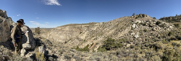
The geology of Wyoming’s state parks draws visitors. The WSGS puts overviews of interesting geologic features into the hands of park visitors through an informational pamphlet series. The newest pamphlet, published in December, spotlights Sinks Canyon State Park.
Sinks Canyon is nestled outside the town of Lander on the eastern side of the Wind River Range. The canyon walls have rocks formed by early oceans and sand dunes; deposits from glaciers cover the canyon floor.
The roaring Middle Fork of the Popo Agie River starts high up in the Wind Rivers, flowing down the canyon and into town.
The most popular attraction to the park is the Sinks-and-Rise. The Middle Fork of the Popo Agie seemingly vanishes as it reaches the side of the canyon wall, at the “Sinks,” only to reappear further down and on the other side of the highway at what is known as the “Rise.”
The new information pamphlet covers these geology nuggets and more. It also includes a geologic map of the park, details about the various rock formations, and the mountain-building event that led to the towering peaks.
The Sinks Canyon pamphlet joins others on state parks Bear River, Boysen, Buffalo Bill, Curt Gowdy, Edness K. Wilkins, Glendo, Guernsey, Hot Springs, Keyhole, and Seminoe. Pamphlets are available as free downloads from the WSGS website. Hardcopies can be picked up at the Survey’s office on the University of Wyoming Campus in Laramie or ordered by mail (with a shipping fee) at the WSGS sales site. Many are also available at state rest areas and visitor centers.
For the last five years, the WSGS has started off the New Year by releasing summary reports highlighting developments in geologic topics relevant to Wyoming. The themes each year have varied, depending on what occurred in the previous 12 months, but the overall goal of offering a brief synopsis remains the same. This year’s reports cover uranium and oil and gas, and what transpired in those industries in the state in 2023.
Uranium
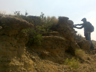
The largest-known economic uranium ore reserves in the United States are in Wyoming—specifically the Powder River Basin, Great Divide Basin, Shirley Basin, and Gas Hills. Last year offered promise for uranium, which is the fuel for nuclear power, as prices improved and support for nuclear energy grew, among other factors.
Low prices over the past decade have seriously depressed domestic uranium production. But over the past two years, prices for yellowcake—uranium concentrate—experienced an upward trend. By the end of 2023, spot prices stood at $91 per pound, a 16-year high. Prices have continued to climb into 2024, breaking $100 per pound. The stronger prices are due to several reasons, including forecast supply and demand gaps, increased opportunities for uranium producers to sign long term supply contracts with nuclear utilities, uncertainty with global supply chains, and reductions in existing supplies of yellowcake available in the spot market.
The Uranium Resources Summary of 2023 report provides historical context for uranium at the state and national levels, details the growing optimism surrounding the industry and nuclear energy, summarizes effects from global events and federal and state incentives, and touches on activity at uranium mines in Wyoming.
Caption: Map of Wyoming showing uranium mines and projects in 2023, including fully constructed in-situ recovery mines, early stage exploration projects, and former mines. Each licensed operation is approved to process a maximum amount of source material per year; this value is reported in green, if known.
Oil and natural gas
Given its importance to the state’s economy, oil and natural gas is a topic covered in the WSGS summary report series every year. The latest report compares oil and natural gas production developments at the national level to here in Wyoming, and explains the reasoning behind some of the differences.
Numbers are still being finalized, but the forecast estimates that around 96 million barrels of oil were produced in Wyoming in 2023*—about 4 million more barrels than in 2022.
Fewer new gas wells were drilled last year, which caused natural gas production in Wyoming to continue its downward trend. Last year’s production is estimated to be around 1.24 trillion cubic feet*, which if accurate once finalized, is about 100 billion cubic feet less than was produced in 2022.
One piece of good news is potential interest by operators in new wells is growing. At least 121 applications for gas well permits-to-drill were submitted to the Wyoming Oil and Gas Conservation commission in 2023*. This is 65 percent more permit applications than in 2022.
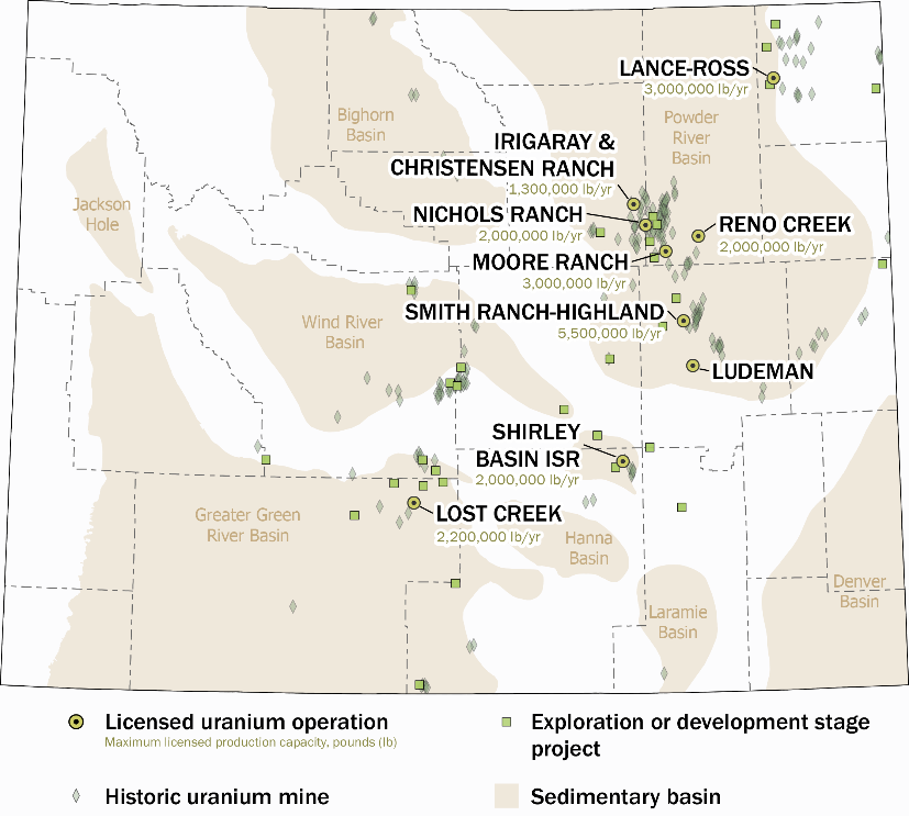
This year’s oil and natural gas summary report also provides information on pore space, specifically as it relates to carbon capture, use, and storage, or CCUS. In addition to clarifying why Wyoming is a favorable location for CCUS, the report offers brief overviews on the geology of CCUS as well as the legal framework for it in Wyoming. Links to several additional resources on the topic are also included in the report.
*These figures are different from what are in the summary report as they reflect updated information since the report was published at the beginning of the year.
Map of Wyoming showing planned CCUS projects and related infrastructure such as CO2 processing plants, pipelines, oil and gas fields, power plants, and refineries. The size of CCUS projects, power plants, and refineries on the map corresponds to their operating capacity; operating capacity of CCUS projects labeled if known. The Dry Fork Station, Sweetwater Carbon Storage Hub, and Echo Springs projects are Department of Energy-funded CarbonSAFE initiatives administered in cooperation with the University of Wyoming’s School of Energy Resources.
Derek Lichtner—Geologist, hired in 2019, contractor on various WSGS projects since 2015
What do you do at WSGS? As a geologist, I have worked on a variety of projects: mapping bedrock and surficial geology, collecting and analyzing rock samples that may contain critical minerals, and coding python scripts that calculate oil and gas statistics and process data related to geographic information systems (GIS).
What makes your job interesting? Doing geology is like solving a big, complicated puzzle—actually a lot of different puzzles mixed together, with many pieces missing. Every small piece of rock is a clue about the bigger picture. By using data from the rocks along with high-tech tools like aerial photos and LiDAR, plus maybe some computer code, we’re able to piece together a lot of what has been lost.
How does your job help Wyoming? Interpreting Wyoming’s geologic past not only guides the sustainable use of the state’s abundant natural resources but also paves the way for new uses of geologic data. In this way, the work we do at the WSGS ensures that Wyoming continues to benefit from its geological heritage while planning responsibly for its future.
What are some of your favorite geologic features in Wyoming and why? Recently, I have been enjoying the Red Desert. Its landscape is a striking blend of open, sagebrush-filled expanses and badlands mazes, both stark and stunning. What makes the Red Desert captivating to me geologically are its Cretaceous and Eocene formations, which tell a compelling story of the final days of an ancient seaway and the rise of mountains during the Laramide orogeny. To top it off are the unique, relatively young volcanic rocks of the Leucite Hills. The Red Desert is, simply put, a classic example of Wyoming's basins.
In Wyoming, we have been the fortunate recipients of several million dollars in airborne geophysical surveys, funded by the USGS and State of Wyoming. These surveys are currently being conducted or are already flown, and the data are being collected and processed. Earlier this month, the USGS released data from a survey flown last year in central Wyoming. These datasets can benefit the mining industry and oil and gas industry, as well as researchers studying geologic hazards and groundwater—all of which ultimately benefit residents of the state.
These are not the first high-quality geophysical surveys to be collected in Wyoming. Most prior data were collected privately, and are, quite understandably, kept confidential by the companies that paid for them. Unfortunately, private data and their interpretations are often lost when companies move out of Wyoming or if companies are dissolved. When the next group of geologists becomes interested in exploring for minerals in Wyoming, they may collect the same data or conduct a similar exploration in the same location as the previous company. This is one reason why publicly available data are so important in moving the state forward. Millions of dollars and countless hours can be saved by preventing the duplication of work.
Another compelling reason for publicly available data is that companies who may not want to commit to a large exploration program in a new location may take the time to explore publicly available geophysical and geologic data from the convenience of their desks. Areas that may not be appealing for mineral exploration from perusal of geologic maps may yield surprising results and lead to new areas of exploration.
As WSGS scientists, we pride ourselves in gathering and distributing data and interpretations to the public. We have databases, logs, geochemical data, age data, maps, and reports, all of which are available online so they can be accessed for free from around the world. Although there are some data held confidential for a limited period of time, the majority are available immediately. All of our efforts are aimed at building the foundation for advancing the understanding of the geology of Wyoming, and as our motto states, “Interpreting the past, providing for the future.”
|