|
Wyoming State Geological Survey (WSGS) geologists typically spend their summer months in the field collecting data. This year was no exception; staff were in northwest Wyoming, the Great Divide Basin in south-central Wyoming, and in the Medicine Bow Mountains gathering information for upcoming geologic maps.
But this past summer, the WSGS was also monitoring data updates from airborne geophysical surveys that flew in central and southeast Wyoming as part of a team effort with the U.S. Geological Survey (USGS). The primary focus of the work is mineral resources, and in some cases geologic hazards such as earthquakes.
Two of the three high-resolution magnetic and radiometric surveys are now fully done. The completed surveys flew over the greater South Pass-Granite Mountains region in central Wyoming and the Medicine Bow Mountains in southeastern Wyoming. Helicopters began flying the third project—the Sierra-Madre-Elkhead Mountains-Medicine Bow Mountains—in September and will do so until weather no longer permits.
The resulting data from the three surveys will be reviewed, verified, and released to the public as a USGS Survey Earth Mapping Resources Initiative data release. The geophysical surveys will be followed by continued research, including new geologic mapping and other interpretive techniques to study the geology and mineral resource potential of the respective areas.
More than 9 million tons of aggregate were produced in Wyoming last year. Other production numbers in tons for the state in 2022, according to the State Mine Inspector’s Office, include:
- Coal—244,265,803
- Gypsum—484,387
- Trona—18,482,320
- Bentonite—9,051,113
- Limestone—2,198,621
- Sand and Gravel—2,954,000
These mineral production values from last year are only a sliver of what can be found on a new WSGS online map. The Mineral Resources of Wyoming, launched in late summer, offers users an interactive way to investigate minerals in the state. Map layers range from geochemical data to critical mineral systems, and from mines to statewide mineral maps published by the WSGS that have been made interactive. There are also a series of layers showing study areas for WSGS mining district publications.
While most WSGS interactive maps are updated annually, the minerals map will likely be updated more frequently as new data are collected. Updates may also be made based on feedback from users who have suggestions to improve the dynamic product.
“Recently, I added the Bureau of Land Management field office areas and am working on a query system for critical minerals,” says Jim Stafford, a geohydrologist and map developer at the WSGS. “My colleague Colby Schwaderer has compiled a database of Mineral Exploration Assistance Programs applications that will soon be added. Also, we just added the 2022 top-producing mines, mentioned above, to the map.”
Data on the map are non-proprietary and were compiled from scientific journals, the USGS, WSGS, Wyoming Department of Environmental Quality, Wyoming Office of State Lands and Investment, as well as from other state and federal agencies and various researchers.
In addition to the Mineral Resources of Wyoming map, other WSGS interactive maps cover geothermal, geologic hazards, geology in Yellowstone National Park, groundwater, and oil and gas. The survey has also developed an interactive map of its geologic map index.

Tammy Mack—Administration Manager, hired in 2019
What do you do at WSGS? I am the manager of the Administration Division, which supports the WSGS scientists and their work. This includes the daily operations of the agency, including its assets, budget, support staff, building maintenance, and upgrades, and I serve as the onsite human resources representative. When people appreciate your work, it can motivate you to do more and continue challenging yourself. This position has allowed me to learn, grow, and improve, which has brought me personal satisfaction.
What makes your job interesting? While much of my work is routine on a daily, weekly, or monthly schedule, within the agency there is always something new happening in the form of outreach events or projects that bring new information and discoveries to light about the state.
How does your job help Wyoming? Work is most rewarding when you can do something that brings value to others. I feel that by supporting the scientists in valuable work they do for Wyoming, I am making a difference for my state. I feel connected through the work being done here and the impact that work makes for the state and its residents.
What are some of your favorite geologic features in Wyoming and why? As a lifelong resident of the state I love everything about its unique geology and diversity. I have some favorites, like Devils Tower and the surrounding area, and the different hot springs areas throughout the state. Fossil Butte is amazing, and you are allowed to do a fossil fish dig when you visit. I enjoy a drive anywhere within Wyoming, and now I notice geologic features in everything I see thanks to my time spent among the geologists on staff at the Survey. I have learned a lot about Wyoming geology and how it happens.
|
Yellowstone Caldera Chronicles is a weekly column written by scientists and collaborators of the Yellowstone Volcano Observatory. The article below was written by James Mauch, a geologist with the WSGS, and was published on Aug. 28, 2023.
It’s hard to overstate the importance of geologic maps to the modern understanding of Yellowstone’s geologic history. After all, it was detailed maps of volcanic rocks on the Yellowstone Plateau that led to the recognition of Yellowstone’s three most recent caldera-forming eruptions. These were classic bedrock geologic maps, meaning they primarily depict rock units and geologic structures that help geologists determine what’s happening underground.
Less widely recognized, but similarly important, are surficial geologic maps, which show the distribution of the materials and deposits that are at or within a few meters (yards) of the ground surface. In many landscapes around the world, including Yellowstone, bedrock is only occasionally exposed at the ground surface. Instead, there is often a veneer of unconsolidated material that has weathered in-place (residuum) or that has been transported from somewhere else (sediment). While bedrock maps typically omit this veneer in order to show the underlying, consolidated rock units, the unconsolidated material at the surface holds its own information and is the primary subject of surficial geologic maps.
What can we learn from surficial geologic maps? From a practical perspective, surficial maps provide fundamental information about the earth materials humans are most likely to interact with—that is, those near the ground surface. For instance, surficial maps are used to site roads and pipelines, highlight areas of slope instability, and predict the movement of shallow groundwater contaminants. For scientific purposes, surficial geologic maps give insight into a landscape’s recent geologic history. Information about earth-shaping processes like glaciation, earthquakes, and river incision are all recorded in surficial deposits.
Reading a surficial map is similar to reading a bedrock map in that polygons symbolized with colors and patterns refer to different map units and show their distribution across the study area. Surficial geologic units are typically classified according to a basic deposit type, then subdivided by texture, composition, or age. Points and lines on the map highlight other surficial features important to the geologic interpretation, such as glacial erratics, former lake shorelines, and fault scarps.
There is a strong history of surficial geologic mapping in the Yellowstone region. In the 1970s, Ken Pierce, Gerald Richmond, and Henry Waldrop published 18 surficial geologic maps at 1:62,500 scale that cover Yellowstone National Park. These maps were an enormous undertaking and required many summers of fieldwork in the Yellowstone backcountry. Furthermore, the work laid the foundation for Ken Pierce’s pioneering research on the Quaternary (the past 2.6 million years) geologic history of the Yellowstone landscape and the complex dynamics of the Greater Yellowstone Glacial System.
Geologists today are building upon this legacy. The Wyoming State Geological Survey is nearing completion on a long-term effort to produce 1:100,000-scale surficial geologic maps that cover the entire state, and the agency has recently published several maps in the Greater Yellowstone region. More broadly, surficial geology is undergoing a modern renaissance thanks to the proliferation of lidar data, which gives geologists a detailed view of the ground surface beneath the tree canopy. The recent availability of lidar in Yellowstone has already led to recognition of some spectacular surficial geologic features that were previously unknown, such as landslides and fault scarps, and it promises to fuel research for years to come.
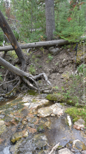
(Photo caption: A cutbank exposure near West DuNoir Creek illustrates the differences between bedrock and surficial geologic mapping. On bedrock maps this location is mapped as the Eocene (55–34 million years old) Indian Meadows Formation, which corresponds to the bedrock visible in the stream bed. On surficial maps this location is mapped as Pinedale-age (22,000–13,000 years old) glacial till, as seen in the 1.5-m-thick package of unsorted sediment in the cutbank. WSGS photo.)
|
On the third Thursday of every October, an international earthquake drill called the Great Shakeout occurs. This drill is designed to promote awareness and preparation for earthquakes and highlights what to do during and after a seismic event.
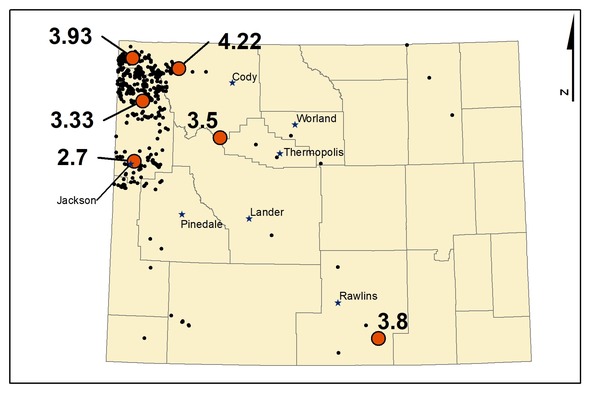
Many people do not know Wyoming has the potential for earthquakes. However, large events can, and do, happen in the state. In fact, there were 2,206 earthquakes recorded last year in the state—13 were above a magnitude of 3.0 and at least 6 were large enough to be felt. The U.S. Geological Survey classifies portions of Wyoming, primarily the west and northwest portions of the state, as having “high seismic hazard.” These regions are where the majority of Wyoming’s earthquakes occur.
Unfortunately, no one can predict earthquakes, but we can identify areas where they are more likely to occur based on historic record. In Wyoming, earthquakes are associated with both the Yellowstone Volcanic System and the Basin and Range Province. The Basin and Range Province extends from western Wyoming to Nevada and it hosts relatively young geologic faults formed by crustal extension.
The largest earthquake recorded in Wyoming was August 18, 1959, in Yellowstone National Park. It registered as a magnitude 6.3 earthquake and is interpreted to be an aftershock of the magnitude 7.2 earthquake at Hebgen Lake in southwestern Montana. The Hebgen Lake earthquake occurred on a fault interpreted to be on the western margin of the Basin and Range extension. The event was large enough to create a significant landslide that claimed many lives and blocked the Madison River to create Quake Lake, which is still present today.
What should you do during an earthquake? Remember to Drop, Cover, and Hold On.
Drop onto your hands and knees. This protects you from being knocked down; moving around is very difficult during a large earthquake.
Cover your head and neck, and crawl under a nearby table, chair, or desk if possible. If you are indoors and no shelter is nearby, crawl to an interior wall.
Hold on to whatever shelter you are under and be ready to move with it if it shifts. If you are in a wheelchair or using a walker, lock the wheels and crouch over covering your head and neck until the shaking stops.
Do not run outside because many buildings have features that could become dislodged during shaking, causing injury. Stay where you are, in your protected position, until all shaking stops, then look around and assess your surroundings before standing up or moving. Keep an eye out for electrical lines or other dangers as you carefully move outside.
If you are already outdoors, stay away from buildings and other structures, including power lines, signs, and trees. Again, you should Drop, Cover, and Hold On.
What can you do to prepare for an earthquake? Secure hazardous and moveable items, such as tall bookcases, picture frames, and water heaters, which can be strapped or bolted to the wall. Make a plan with family and friends as to how to communicate and where to meet after an event; this is a good idea for all emergencies, not just earthquakes. Remember, it is typically easier to send and receive text messages after an event than to make phone calls. As for any disaster, keep supplies of water, food, and medication in your home. This key step will provide resources as you wait for help to arrive. Don’t forget to account for the needs of your pets. The Wyoming Office of Homeland Security suggests being “Two Weeks Ready” for any disaster. You can find more information about that initiative at https://hls.wyo.gov/being-prepared/two-weeks-ready.
Visit the WSGS earthquakes webpage to learn more about earthquakes in Wyoming.
--Dr. Erin Campbell, WSGS Director and State Geologist
Earthquakes in Wyoming during 2022. Of the 2,206 events, six were reported felt (shown as orange dots with recorded magnitude) by the U.S. Geological Survey’s “Did You Feel It” program.
|