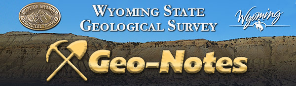
Wyoming State Geological Survey (WSGS) geoscientists are spending the summer in south-central and southwest Wyoming mapping and field checking existing interpretations for a pair of 1:100,000-scale bedrock geologic maps.
The adjacent Red Desert Basin and Rawlins 30' x 60' quadrangles occupy nearly all of the Great Divide Basin, spanning an area between Rock Springs and Rawlins. Contained within both quadrangles are similar geologic units that share a deformation history related to the Laramide Orogeny. With the exception of the Rawlins Uplift that hosts rocks that range from 2.6-billion-year-old granite and gneiss to less than 22-million-year-old sedimentary basin fill, most of the mapping area is blanketed by Cretaceous and Paleogene sedimentary strata deposited in shallow marine, nearshore, fluvial, and lacustrine environments.
These maps are key in the WSGS's effort to complete the mapping of Wyoming at the scale of 1:100,000, using modern digital methods following the Geologic Map Schema (GeMS) standards defined by the U.S. Geological Survey and used in most states. Digital maps at this scale are useful for regional geology and regional exploration for oil, gas, and minerals.
Both maps are partially funded through the U.S. Geological Survey’s STATEMAP program and are scheduled to be published in 2025. The WSGS has participated in this and related federal mapping programs for nearly 30 years, and to date has produced more than 160 geologic maps at the 1:24,000 and 1:100,000 scales.
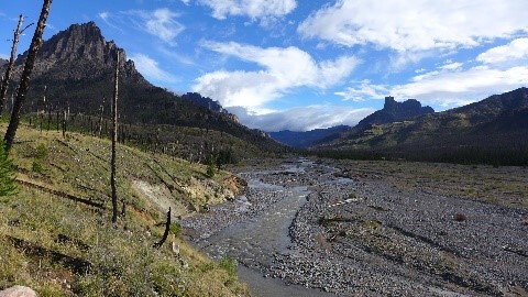
(Photo caption: Some of the youngest igneous rocks in Wyoming are part of the Leucite Hills, within the Red Desert Basin 30' x 60' quadrangle. The Quaternary Leucite Hills are comprised of lamproite, an ultrapotassic volcanic rock, that forms buttes and mesas that rise above the Cretaceous and Paleogene strata in the northeastern part of the Rock Springs Uplift. James Mauch, known for studying Quaternary landforms and Holocene faults, doesn't usually have the opportunity to sample volcanic rocks like he is here. Photograph is from the flank of Steamboat Mountain.)
|
The WSGS published a new 1:100,000-scale surficial geologic map of the west half of The Ramshorn 30' x 60' quadrangle. The map area includes the northwestern Wind River Range and Wind River Basin, and the southern Absaroka Range in northwest Wyoming.
The project focused on understanding the geologic hazards and Quaternary geologic history of the map area. The quadrangle lies within one of Wyoming’s most landslide-prone regions, and landslides have historically impacted U.S. Highway 26/287—an important transportation corridor that crosses the southwest corner of the map.
As part of the mapping, geologists updated a 30-year-old landslide inventory through interpretation of 1-meter-resolution, bare-earth lidar data and select ground truthing. The mapping also sheds light on the dynamics of Pleistocene glacial systems in the Wind River and Absaroka ranges by documenting the spatial extent and source areas for multiple generations of glacial deposits.
Much of the quadrangle is designated wilderness, and the difficulty of accessing parts of the field area necessitated a combination of digital and field mapping approaches.
“The remote nature of this map area was both a challenge and an opportunity,” says WSGS geologist James Mauch. “We had to lean heavily on digital methods of lidar and image interpretation to map the surficial geology of much of the northern half of the quadrangle. The inaccessibility of this area also meant that there was little previous mapping—in many places only consisting of very coarse-scale work from the statewide map—which gave us a blank slate to make our own original interpretations.”
Methods used in the study, as well as information about the quadrangle’s previous mapping efforts, geologic setting, map unit descriptions, and interpretation of the area’s Quaternary geologic history are detailed in a report that accompanies the map. The map is available as a free downloadable PDF, as a hardcopy for purchase from the WSGS, and as downloadable GIS data. This project was supported with funding through the U.S. National Cooperative Geologic Mapping Program (STATEMAP), which is managed by the U.S. Geological Survey.
Braided channel of the Wiggins Fork near the southern margin of the Absaroka Range. Pinedale glacial till overlies steeply dipping Paleozoic bedrock to the left.
Colby Schwaderer—Geologist, hired in 2023
What do you do at the WSGS? As a team member in the WSGS geologic hazards and mapping division, I contribute to a multitude of projects aiming to improve surficial and bedrock geologic maps, evaluate and describe existing and potential geologic hazards, and to catalog useful geospatial data utilizing GIS tools. These efforts are incredibly important to better understand our state’s diverse geological resources and help make informed decisions with regard to infrastructure planning, hazard mitigation, and sustainable resource development. Looking forward to future projects, I am excited to continue to familiarize myself with our state’s diverse bedrock geology and to explore more about variable climatic influence on erosion and deposition in modern and ancient sedimentary systems near active mountain fronts.
What makes your job interesting? My job allows me the unique opportunity to combine my personal and professional interests to explore unique geologic landscapes in many dramatically different environments. I am truly amazed by the wide geological diversity throughout the state and have been fortunate to be involved in so many different projects to expand my expertise in diverse fields as a geoscientist. During my master’s research at the University of Wisconsin-Madison, I was particularly interested in investigating climatic and tectonic controls on sediment supply and deposition in ancient paleolake systems in the Green River Basin that provide key economic resources and invaluable paleoclimate archives unique worldwide and only found in central Wyoming. Building upon this experience with my role at the WSGS has been incredibly formative and has created many new opportunities to solve other unique geologic puzzles and investigate modern geologic processes currently shaping our landscape today.
How does your job help Wyoming? Better understanding the regional bedrock characteristics, known hazards, and hazard potential are essential elements for future infrastructure planning and hazard mitigation. Whenever new roadways, bridges, or other municipal projects are being considered, engineers rely extensively on accurate geologic maps and hazard analyses for site evaluation to prevent structural failures and ensure public safety. Additionally, geologic mapping efforts and mineral surveys are useful for appraising the quality and distribution of valuable economic mineral and groundwater resources. Overall, our primary mission as geoscientists at the WSGS is to prepare and freely distribute useful, current, and detailed geologic information essential to make informed decisions for responsible resource development and public safety.
What are some of your favorite geologic features in Wyoming and why? As a relatively new addition to the state, I still have a lot to see, but when able, I have taken every opportunity to explore our beautiful state! Amongst my favorite places so far: I am always awed by the stunning colors, structure, and diversity of early Eocene sedimentary strata exposed in Firehole Canyon, Delaney Rim, and Steamboat Mountain, associated with fluvial and lacustrine facies deposited along ancient paleolakes Fossil and Gosiute in the central park of the state. Upon closer inspection, these humble sedimentary beds tell a dynamic story recounting changing climatic conditions, mountain-building events, and changes in ancient biological communities dramatically different than what we currently see today.
|
During the summer, many of us head to water for recreation, whether it’s for swimming, fishing, boating, or camping. Although Wyoming can’t match Minnesota’s 10,000 lakes, the 1,250 lakes it does host provide considerable fun and have fascinating origins.
Wyoming also holds 501 reservoirs and 6,786 ponds. Before diving into interesting facts about Wyoming’s lakes, we need to first define how a lake differs from a reservoir or pond.
A reservoir is a manmade lake created when a dam is built on a river, a lake forms where surface water and/or groundwater seepage accumulate in a low spot in topography or is held by a natural dam, and a pond is any small, unnamed body of water.
Now back to lakes.
Natural lakes in Wyoming can be dammed by features such as landslides and glacial moraines (mounds of sediment left behind when a glacier retreats). For example, Lower Slide Lake formed east of Jackson Hole on the Gros Ventre River as a result of the 1925 Gros Ventre Landslide, which initially created a 200-foot-high and 700-foot-long dam. The most famous lake in Wyoming formed by a glacial moraine is Jenny Lake in Grand Teton National Park. The lake lies at the base of Cascade Canyon, which was carved out by a glacier during the last glacial maximum. When the glacier retreated, it left behind a terminal moraine that holds this incredibly scenic lake.
The highest concentration of bodies of water in the state is found in the Wind River Range, which hosts about 1,300. Some of those lakes are found near or downstream from glaciers, such as Scott Lake by Mammoth Glacier and Iceberg Lake by Sourdough Glacier.
Many Wyoming lakes lie in topographic lows caused by glacial scouring, such as the deepest lake in the state: Fremont Lake in the Wind River Mountains near Pinedale. The 610-foot-deep lake was originally dammed by a terminal moraine. The natural glacial dam was expanded in the 1930s to raise the lake level by 2 feet, and again in 1994, adding another 3 feet to the reservoir.
Yellowstone Lake also lies in a topographic depression—the Yellowstone Caldera, where the magma chamber collapsed after a large eruption. The floor of the lake continues to rise and fall slightly as magma moves in the chamber below the lake. Yellowstone Lake hosts many underwater geothermal springs. It is also Wyoming’s largest lake, covering 84,500 acres (about 132 square miles), and sits at an elevation of 7,730 feet above sea level, making it the largest body of water in North America above 7,000 feet and the second largest in the world at that elevation.
Another interesting lake in Wyoming is Lake De Smet, north of Buffalo. Lake De Smet lies in a surficial depression that formed long ago due to collapse from underground coal-seam fires. That region of the Powder River Basin is notable for its outcrops of red clinker, which are baked and melted rocks formed by the natural, underground burning of coal. The 150- to 200-foot-thick coal layers burned to create large voids, which collapsed under the weight of overlying layers. This formed a natural basin that filled with water over time, and to which settlers later added dams, and intakes and outlets.
Since this is Wyoming, there are also lakes located due to wind. For example, Lake Hattie, west of Laramie, lies in a topographic low in Big Hollow, which is a wind eroded basin. Big Hollow is the largest deflation basin (where sediments are removed by wind) in North America and second largest in the world.
These are just a handful of the many lakes in Wyoming. There are lots to explore, and hopefully you’ve had a chance to experience a few this summer.
--Dr. Erin Campbell, WSGS Director and State Geologist
|
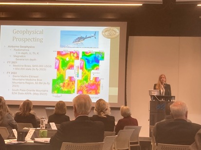 |
WSGS Director and Wyoming State Geologist, Dr. Erin Campbell, spoke during the May 8 Wyoming Energy Authority Energy Summit in Cheyenne. Campbell gave a brief talk in the Ignite Session on “Geophysics and Critical Minerals Large Projects in Wyoming,” and outlined the geophysical surveys the WSGS is involved with this summer and how they will benefit Wyoming. Read about the geophysical surveys in the spring newsletter.
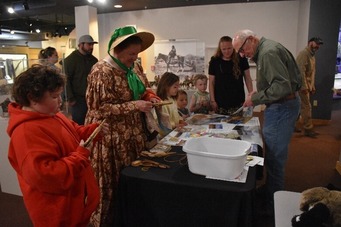
The WSGS attended the Oregon Trail Family Day event in June at the Wyoming State Museum in Cheyenne. Staff Jill Ottman (in the bonnet) and Kurt Hinaman (at right) discussed the geology along the trail pioneers would have encountered while crossing Wyoming.
(Wyoming State Museum photo)
|
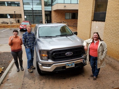
Staff (from left) Kelsey Kehoe, James Mauch, and Jill Ottman were all smiles next to the Survey’s new fleet vehicle, a Ford F150 affectionately referred to as, “Effie.” Geologists spend summers in the field collecting data and essential to having a good trip is having a good field vehicle.
|
|