|
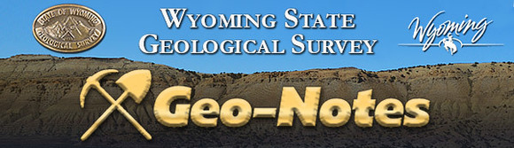
The Wyoming State Geological Survey (WSGS) published a new report focused on coal resources within the Fort Union Formation across the Washakie and Great Divide basins. Report of Investigations 76 estimates coal availability in the two basins (primarily in Carbon and Sweetwater counties), and is the most comprehensive stratigraphic correlation of Fort Union coal beds in that region to date.
Coal beds in three historic mining areas—the Little Snake River, Rawlins, and Rock Springs coal fields—were correlated across the basins. Of the 80-plus individual coal beds identified using geophysical logs from subsurface oil and gas wells, the 12 thickest and most continuous coals were selected for spatial modeling. Results from the model include maps of bed thickness, overburden, and areal extent for each of the 12 coal groups. The results were then used to estimate original and available coal resources, as well as the demonstrated reserve base of coal within the Fort Union Formation.
More information about the regional assessment is in the news release.
Earthquakes, landslides, and other geologic hazards occur across Wyoming, and now the public can learn about their occurrences more easily with a new online interactive map developed by the WSGS. The goal of the map is to provide a central location that hosts the most relevant general information related to geologic hazards in the state.
Geologic hazards refer to the geologic conditions that cause risk to people and property. In addition to earthquakes and landslides, in Wyoming this can include windblown deposits, expansive soils, and faults that have been active within the last 1.6 million years.
The new map is intended to be simple to use but contain a significant amount of data and provide pathways to deep research when desired. Features include historic and recent earthquake data, landslides mapped by the WSGS, and status and location of faults. Learn more about the map’s features in the news release.
The Wyoming Geologic Hazards Map is the WSGS’ fifth online interactive map. Others are: Oil and Gas Map of Wyoming, Geochronology Map of Wyoming, Groundwater Atlas of Wyoming, and Mines and Minerals Map of Wyoming.
There is no cost to access these maps.
The WSGS published a series of summary reports highlighting issues and opportunities related to the state’s geology in 2018. The three publications provide synopses of Wyoming’s oil, natural gas, and coal industries; critical mineral resources; and geologic hazards.
“There are many important geologic issues in Wyoming, and these summaries provide residents, elected officials, and state government with a snapshot of energy and mineral resources in Wyoming, as well as the geologic hazards that exist,” says WSGS Director, Dr. Erin Campbell.
The summary reports are available free of charge at the WSGS office on the University of Wyoming campus in Laramie and on the agency’s website. Read more about the series in the news release.

The WSGS developed a new webpage, Critical Minerals in Wyoming, about the 35 minerals deemed critical by the U.S. Department of the Interior and their occurrences in the state. The federal agency defines a critical mineral as: a non-fuel mineral or mineral material essential to the economic and national security of the United States; the supply chain of which is vulnerable to disruption; and that serves an essential function in the manufacturing of a product, the absence of which would have significant consequences for our economy or our national security.
Many of the critical minerals on the list, which was finalized in 2018, are actually individual elements. Of the 35 listed, six were determined to have high potential in Wyoming: helium, platinum group elements, rare earth elements (a group of 17 elements), titanium, uranium, and vanadium.
More information about critical minerals in Wyoming can be found in the 2018 summary report.
|
The WSGS is developing a new way to investigate the spatial distribution of elements in rocks and sediments across Wyoming.
The computer model incorporates geochemical analyses from 48,000 samples for up to 67 different elements collected largely as part of the National Uranium Resource Evaluation program and the National Geochemical Database. This model uses these samples to estimate the statewide known and potential areas for each element. Additionally, it documents areas of un-sampled and unlikely potential.
The tool will provide a statewide view of elemental distribution, guiding the WSGS to areas of sparse data or potential prospects that require further study. This project fulfills the WSGS’ mission of promoting Wyoming’s mineral resources and is the first step in assessing the state’s critical mineral resources.
The project will be released as an open file report in 2019, with accompanying spatial data available as layers on the Mines and Minerals Map of Wyoming and as a geodatabase for use with ArcGIS.
Are you looking for a specific WSGS publication or want to browse what we have available?
The Survey created an online tool to search its more than 1,600 publications. The search tool makes it easy to look up reports and maps by a publication’s number, year, title, and author(s). The user can either download publications at no charge or choose to purchase paper copies when available on the WSGS Publications Sales and Free Downloads website.
Beginning this winter, all data or maps that supplement a publication will also be available for download through the publication search tool, allowing the user a simple way to access this additional information.
The Wyoming State Mineral & Gem Society recognized WSGS geologist Wayne Sutherland in its Jade State News publication, awarding him the Wyoming RockStar Award. The article notes Sutherland has "gone above and beyond his job at the Wyoming State Geological Survey to benefit Wyoming rockhounds."
Read the full article in the Jade State News.
|